Krivaja, Bačka Topola
| Krivaja Криваја | |
|---|---|
| Village | |
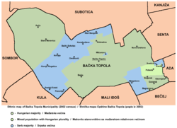 Map of the Bačka Topola municipality showing the location of Krivaja | |
 Krivaja Map of the Bačka Topola municipality showing the location of Krivaja | |
| Coordinates: 45°42′30″N 19°39′55″E / 45.70833°N 19.66528°E | |
| Country |
|
| Province |
|
| Population (2002) | |
| • Total | 986 |
| Time zone | UTC+1 (CET) |
| • Summer (DST) | UTC+2 (CEST) |
Krivaja (Serbian Cyrillic: Криваја) is a village in Serbia. It is situated in the Bačka Topola municipality, in the North Bačka District, Vojvodina province. The village has a Serb ethnic majority and its population numbering 986 people (2002 census).
Name
In Serbian the village is known as Krivaja (Криваја), in Hungarian as Bácsér or Kanyarodó, and in Croatian as Krivaja.
Historical population
- 1981: 680
- 1991: 910
- 2002: 986
References
- Slobodan Ćurčić, Broj stanovnika Vojvodine, Novi Sad, 1996.
See also
Cities, towns and villages in the North Bačka District | ||
|---|---|---|
| Subotica | 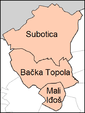 | |
| Bačka Topola | ||
| Mali Iđoš | ||
(*) bold are municipalities or cities | ||
Coordinates: 45°42′30″N 19°39′55″E / 45.70833°N 19.66528°E
This article is issued from
Wikipedia.
The text is licensed under Creative Commons - Attribution - Sharealike.
Additional terms may apply for the media files.