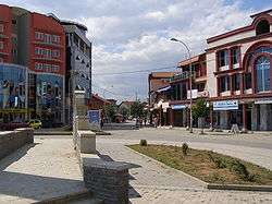
Klina
| Klina Klina or Klinë (Albanian) Клина/Klina (Serbian) | |
|---|---|
| Town and municipality | |
 | |
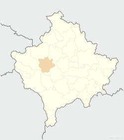 Location of the municipality of Klina within Kosovo | |
| Coordinates: 42°37′N 20°34′E / 42.617°N 20.567°E | |
| Country | Kosovo[lower-alpha 1] |
| District | District of Peć |
| • Municipal | 309 km2 (119 sq mi) |
| Elevation | 382 m (1,253 ft) |
| Population (2011) | |
| • Urban | 5,542 |
| • Municipal | 38,496 |
| • Municipal density | 120/km2 (320/sq mi) |
| Time zone | UTC+1 (CET) |
| • Summer (DST) | UTC+2 (CEST) |
| Postal code | 32000 |
| Area code(s) | +381 |
| Car plates | 03 |
| Website |
kk |
Klina (Serbian Cyrillic: Клина, Albanian: Klinë) is a town and municipality located in the Peć District of north-western Kosovo[lower-alpha 1]. According to the 2011 census, the town of Klina has 5,542 inhabitants, while the municipality has 38,496 inhabitants. It is located at the confluence of the river Klina into the White Drin.
History
During Early Middle Ages, Porphyrogenitus mentions the urban center of Desstinik, today Dersnik/Drsnik, where important archeological discoveries of Roman period were made in August 2013, described as: ...the most important discovery of the past few decades to have been made in Kosovo in the area of archaeology.[1]
Symbol
A symbol of Klina are the Mirusha Waterfalls.
Economy
There is one bauxite mine operating on the territory of Klina - Grebnik mine.
Demographics
| Historical population | ||
|---|---|---|
| Year | Pop. | ±% p.a. |
| 1961 | 27,153 | — |
| 1971 | 42,351 | +4.55% |
| 1981 | 54,539 | +2.56% |
| 1991 | 52,266 | −0.42% |
| 2011 | 38,496 | −1.52% |
According to the last official census done in 2011, the municipality of Klina has 38,496 inhabitants.
Ethnic groups
The ethnic composition of the municipality:
| Ethnic composition | |||||||||||||
| Year/Population | Albanians | % | Serbs | % | Montenegrins | % | Roma | % | Total | ||||
|---|---|---|---|---|---|---|---|---|---|---|---|---|---|
| 1961 | 18,124 | 66.75 | 7,378 | 27.17 | 1,372 | 5.05 | 80 | 0.29 | 27,153 | ||||
| 1971 | 33,050 | 78.04 | 7,864 | 18.57 | 1,157 | 2.73 | 118 | 0.28 | 42,351 | ||||
| 1981 | 45,594 | 83.60 | 6,829 | 12.52 | 973 | 1.78 | 798 | 1.46 | 54,539 | ||||
| 1991 | 43,248 | 82.75 | 5,209 | 9.97 | 621 | 1.19 | 1,278 | 2.45 | 52,266 | ||||
| January 1999 | 55,000 | 78.6 | 10,000 | 14.3 | 5,000 | 7.1 | 70,000 | ||||||
| 2011 | 37,216 | 96.7 | 98 | 0.25 | - | - | 78 | 0.2 | 38,496 | ||||
| Ref: Yugoslav Population Censuses for data through 1991, Organization for Security and Co-operation in Europe estimates for 1999 and 2006 | |||||||||||||
In September 2014, 12 Egyptian families returned to Klina having spent the last 15 years displaced in Podgorica, Montenegro. The families moved straight into a newly constructed neighbourhood as part of project helping refugees from the Kosovo War return to Kosovo.[2]
Notable people
- Anton Berisha, folklorist and scholar
- Sadik Rama Gjurgjeviku (1879–1944), Kosovo Albanian guerrilla fighter, born in Veliki Đurđevik.
Annotations
- 1 2 Kosovo is the subject of a territorial dispute between the Republic of Kosovo and the Republic of Serbia. The Republic of Kosovo unilaterally declared independence on 17 February 2008, but Serbia continues to claim it as part of its own sovereign territory. The two governments began to normalise relations in 2013, as part of the Brussels Agreement. Kosovo has received formal recognition as an independent state from 113 out of 193 United Nations member states.
References
- ↑ Archaeological discoveries in Dresnik of Klina, the most intriguing discovery of the past few decades, Ministry of Culture, Youth, and Sport of Kosovo, 2013-08-15
- ↑ "Egyptians return to Kosovo after 15 years of displacement". Shanghai Daily. 15 September 2014. Retrieved 16 September 2014.
External links

- Komuna Klina
| Ferizaj District |  | |
|---|---|---|
| Gjakova District | ||
| Gjilan District | ||
| Mitrovica District | ||
| Peć District | ||
| Pristina District | ||
| Prizren District | ||
1 Kosovo is the subject of a territorial dispute between the Republic of Kosovo and the Republic of Serbia. The Republic of Kosovo unilaterally declared independence on 17 February 2008, but Serbia continues to claim it as part of its own sovereign territory. The two governments began to normalise relations in 2013, as part of the Brussels Agreement. Kosovo has received formal recognition as an independent state from 113 out of 193 United Nations member states. | ||
Coordinates: 42°37′18″N 20°34′40″E / 42.62167°N 20.57778°E