Obilić
| Obilić Обилић/Obilić (Serbian) Obiliq or Obiliqi, Kastriot or Kastrioti (Albanian) | |
|---|---|
| Town and municipality | |
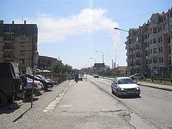 Obilić main street | |
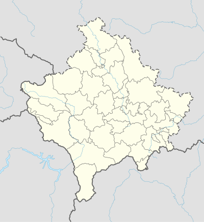 Obilić Location of the municipality of Obilić within Kosovo | |
| Coordinates: 42°41′N 21°04′E / 42.683°N 21.067°E | |
| Country | Kosovo[lower-alpha 1] |
| District | District of Pristina |
| Municipality | 1989 |
| Government | |
| • Mayor | Xhafer Gashi |
| • Municipal | 105 km2 (41 sq mi) |
| Elevation | 526 m (1,726 ft) |
| Population (2011) | |
| • Urban | 6,864 |
| • Municipal | 21,549 |
| • Municipal density | 210/km2 (530/sq mi) |
| Time zone | UTC+1 (CET) |
| • Summer (DST) | UTC+2 (CEST) |
| Postal code | 15000 |
| Area code(s) | +383 38 |
| Car plates | 01 |
| Website |
kk |
Obilić (Serbian Cyrillic: Обилић), or Obiliq or Kastriot (Albanian: Obiliqi or Kastrioti), is a town and municipality located in the Pristina District of Kosovo[lower-alpha 1]. According to the 2011 census, the town of Obilić has 6,864 inhabitants, while the municipality has 21,549 inhabitants. The municipality includes the town of Obilić and 19 villages.[1]
The municipality is located immediately north-west of Pristina on the main road to Mitrovica. It was created in 1989, prior to which it formed part of Pristina municipality.[1]
Name
The name for the town, Obilić, refers to Serbian national hero Miloš Obilić who killed the Ottoman Sultan Murad I at the Battle of Kosovo (1389). In Albanian, the town is known as Obiliq (a transliteration of the Serbian name), while an alternative name (used by Albanian nationalists[2]) was coined by the Albanological Institute, Kastriot, after Albanian national hero George Kastrioti Skanderbeg (1405–1468).[3][4] It was prior to 1912 known as Globoderica (Глободерица).
Economy
There are three coal mines operating on the territory of Obilić: Belaćevac, Miraš and Sibovc. These mines are of tremendous value for Kosovo's economy and energy sector, as more than 97% of Kosovo's annual electricity production comes from there, with coal being the main resource for the power plants. There are two power plants operating on the territory of Obilić which combined produce:
Demographics
| Municipal historical population | ||
|---|---|---|
| Year | Pop. | ±% p.a. |
| 1948 | 9,228 | — |
| 1953 | 10,971 | +3.52% |
| 1961 | 14,899 | +3.90% |
| 1971 | 21,188 | +3.58% |
| 1981 | 26,595 | +2.30% |
| 1991 | 31,627 | +1.75% |
| 2011 | 21,549 | −1.90% |
| 2016 est. | 19,165 | −2.32% |
| Source: Division of Kosovo | ||
According to the 2011 census, the municipality had a population of 21,548 inhabitants.
The ethnic composition of the town of Obilić:[5][6][7]
| Ethnic group | 1961 census | 1981 census | 2011 census |
|---|---|---|---|
| Serbs | 1,778 | 2,828 | 0 |
| Albanians | 1,434 | 3,289 | 6,627 |
| Montenegrins | 248 | 466 | 0 |
| Others | 77 | 2,349 | 227 |
| Total | 3,646 | 8,769 | 6,846 |
Ethnic groups
The majority of the municipality is formed of Kosovo Albanians, with minorities of Kosovo Serbs, Roma, Ashkali, Bosniaks and others.
Gallery
 Kosovo power plant in Obilić
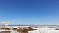 Landscape of Obilić with power station
Notes and references
Notes:
- 1 2 Kosovo is the subject of a territorial dispute between the Republic of Kosovo and the Republic of Serbia. The Republic of Kosovo unilaterally declared independence on 17 February 2008, but Serbia continues to claim it as part of its own sovereign territory. The two governments began to normalise relations in 2013, as part of the Brussels Agreement. Kosovo has received formal recognition as an independent state from 113 out of 193 United Nations member states.
References:
- 1 2 OSCE Mission in Kosovo: Municipal profile of Obilić Archived June 6, 2011, at the Wayback Machine., April 2008. – Retrieved on 30 October 2008.
- ↑ Andreas Wittkowsky (2011). Grand Hotel Kosovo: Schlaglichter einer europäischen Staatsbildung. LIT Verlag Münster. p. 69. ISBN 978-3-643-11425-9.
- ↑ Saskia Drude (2008). Hundert Wochen Kosovo: Alltag in einem unfertigen Land. Karin Fischer Verlag. p. 99. ISBN 978-3-89514-836-1.
- ↑ Jean-Arnault Dérens (2006). Kosovo: année zéro. Editions Paris-Méditerranée. p. 31. ISBN 978-2-84272-248-7.
- ↑ Национални састав становништва ФНР Југославије 1961. године pod2.stat.gov.rs
- ↑ Национални састав становништва СФР Југославије 1981. године pod2.stat.gov.rs
- ↑ Етнички састав становништва Косова и Метохије 2011. године pop-stat.mashke.org Template:Ал
External links
| Wikimedia Commons has media related to Obilić. |
| Ferizaj District |  | |
|---|---|---|
| Gjakova District | ||
| Gjilan District | ||
| Mitrovica District | ||
| Peć District | ||
| Pristina District | ||
| Prizren District | ||
1 Kosovo is the subject of a territorial dispute between the Republic of Kosovo and the Republic of Serbia. The Republic of Kosovo unilaterally declared independence on 17 February 2008, but Serbia continues to claim it as part of its own sovereign territory. The two governments began to normalise relations in 2013, as part of the Brussels Agreement. Kosovo has received formal recognition as an independent state from 113 out of 193 United Nations member states. | ||
Coordinates: 42°41′24″N 21°04′40″E / 42.69000°N 21.07778°E