County statistics of the United States
In 48 of the 50 states of the United States, the county is used for the level of local government immediately below the state itself. Louisiana uses parishes, and Alaska uses boroughs. In several states in New England, some or all counties within states have no governments of their own; the counties continue to exist as legal entities, however, and are used by states for some administrative functions and by the United States Census bureau for statistical analysis. There are 3,242 counties and county equivalent administrative units in total, including the District of Columbia and 100 county-equivalents in the U.S. territories.
There are 41 independent cities in the United States. In Virginia, any municipality that is incorporated as a city legally becomes independent of any county. Where indicated, the statistics below do not include Virginia's 38 independent cities.
In Alaska, most of the land area of the state has no county-level government. Those parts of the state are divided by the United States Census Bureau into census areas, which are not the same as boroughs. The state's largest statistical division by area is the Yukon–Koyukuk Census Area, which is larger than any of the state's boroughs. Although Anchorage is called a municipality, it is considered a consolidated city and borough.
There are 100 county-equivalents in the territories of the United States: they are the 3 districts and 2 atolls of American Samoa, all of Guam (Guam as one single county-equivalent), the 4 municipalities in the Northern Mariana Islands, the 78 municipalities of Puerto Rico, the 3 main islands of the U.S. Virgin Islands, and the 9 islands in the U.S. Minor Outlying Islands.[1][2][3] All of these territorial county-equivalents are defined by the U.S. Census Bureau.
Count
This is the number of counties and county-equivalents for each state, the District of Columbia, the 5 inhabited territories of the United States, and the U.S. Minor Outlying Islands.


Lists of counties and county equivalents by number per political division:
| Count | State, federal district or territory |
Notes |
|---|---|---|
| 254 | The most counties of any U.S. state | |
| 159 | ||
| 133 | including 38 independent cities | |
| 120 | ||
| 115 | including 1 independent city | |
| 105 | ||
| 102 | ||
| 100 | ||
| 99 | ||
| 95 | ||
| 93 | ||
| 92 | ||
| 88 | ||
| 87 | ||
| 83 | ||
| 82 | ||
| 78 | Puerto Rico has no counties. The 78 municipalities of Puerto Rico are counted as county-equivalents by the U.S. Census Bureau. | |
| 77 | ||
| 75 | ||
| 72 | ||
| 67 | ||
| 67 | ||
| 67 | ||
| 66 | ||
| 64 | ||
| 64 | Louisiana has no counties. The 64 parishes of Louisiana are counted as county-equivalents by the U.S. Census Bureau. | |
| 62 | New York City is a sui generis jurisdiction, in which the city government consists of 5 boroughs each coterminous with a county of New York State. | |
| 58 | ||
| 56 | ||
| 55 | ||
| 53 | ||
| 46 | ||
| 44 | ||
| 39 | ||
| 36 | ||
| 33 | ||
| 29 | Alaska has no counties. The following areas in Alaska are counted as county-equivalents: the 19 organized boroughs and, in its Unorganized Borough, of 10 designated census areas. | |
| 29 | ||
| 24 | including 1 independent city | |
| 23 | ||
| 21 | ||
| 17 | including 1 independent city | |
| 16 | ||
| 15 | ||
| 14 | 8 of the 14 counties in Massachusetts were disincorporated in the 1990s and early 2000s; local government in these areas consists of cities and towns. One of the remaining 6 counties is a consolidated town-county. | |
| 14 | ||
| 10 | ||
| 9 | The U.S. Minor Outlying Islands does not have counties. The 9 islands in the U.S. Minor Outlying Islands are counted as county-equivalents by the U.S. Census Bureau. | |
| 8 | County government was abolished in Connecticut in 1960; local government consists of cities, towns, and boroughs.[4] | |
| 5 | The 3 districts and 2 unorganized atolls of American Samoa are counted as county-equivalents by the U.S. Census Bureau. American Samoa locally has 14 “counties”, but these “counties” are not counted as counties by the U.S. Census Bureau (they are treated as “minor civil divisions”).[2] | |
| 5 | ||
| 5 | Counties in Rhode Island have no governmental functions; local government is provided by eight cities and thirty-one towns | |
| 4 | The Northern Mariana Islands has no counties. The 4 municipalities of the Northern Mariana Islands are counted as county-equivalents by the U.S. Census Bureau. | |
| 3 | The fewest counties of any U.S. state | |
| 3 | The U.S. Virgin Islands has no counties. The 3 main islands of the U.S. Virgin Islands are counted as county-equivalents by the U.S. Census Bureau. | |
| 1 | The District of Columbia has no counties; the District of Columbia is considered both a state-equivalent and a county equivalent for statistical purposes[5] | |
| 1 | Guam has no counties; Guam is considered both a state-equivalent and a county-equivalent for statistical purposes by the U.S. Census Bureau (similar to the District of Columbia).[2] |
- Total (50 states and District of Columbia): 3,142 (3,007 counties and 135 county equivalents)
- Total (50 states, District of Columbia and territories): 3,242 (3,007 counties and 235 county equivalents)
- Average number of counties per state (not including D.C. and the territories): 62.82 [note 1]
- Average number of counties per state (including D.C. and the territories): 56.87 [note 2]
Population
Nationwide population extremes
These rankings include county equivalents.
|
|
The following is a list of the least populous counties and county-equivalents in all U.S. territory. Note that the only entity on this list with a permanent human population is Swains Island, American Samoa. The first 8 counties (county-equivalents) are uninhabited, while the 10th on the list (Palmyra Atoll) has a small non-permanent human population whose maximum capacity is 20 people.[7]
| Rank | County | Population |
|---|---|---|
| 1 | Baker Island, U.S. Minor Outlying Islands | 0 |
| 2 | Howland Island, U.S. Minor Outlying Islands | 0 |
| 3 | Jarvis Island, U.S. Minor Outlying Islands | 0 |
| 4 | Johnston Atoll, U.S. Minor Outlying Islands | 0 |
| 5 | Kingman Reef, U.S. Minor Outlying Islands | 0 |
| 6 | Navassa Island, U.S. Minor Outlying Islands | 0 |
| 7 | Northern Islands Municipality, Northern Mariana Islands | 0 |
| 8 | Rose Atoll, American Samoa | 0 |
| 9 | Swains Island, American Samoa[8] [note 3] | 17 |
| 10 | Palmyra Atoll, U.S. Minor Outlying Islands | 20 [note 4] |
 Los Angeles in Los Angeles County, California, the most populous county in the United States
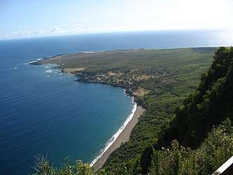 Kalawao County, Hawaii, the least-populous county in the 50 states
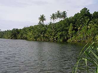 Swains Island, American Samoa — the least-populous permanently-inhabited county or county-equivalent in the United States
Population per state or territory
Area
Nationwide land area extremes
The largest counties and county-equivalents are organized boroughs and the census areas of Alaska with the top two being Yukon–Koyukuk Census Area (145,504.79 sq mi or 376,855.7 km2) and North Slope Borough (88,695.41 sq mi or 229,720.1 km2). The smallest counties and county equivalents (in the 50 states) are the independent cities of Virginia with the extreme being Falls Church (2.00 sq mi or 5.2 km2).[9] If the U.S. territories are included, the smallest county-equivalent is Kingman Reef, with a land area of 0.01 square miles (0.03 km2)[10].
The following two tables exclude county-equivalents:
| Rank | County | Land area (sq mi) |
Land area (km2) |
|---|---|---|---|
| 1 | San Bernardino County, California | 20,056.94 | 51,947.24 |
| 2 | Coconino County, Arizona | 18,618.89 | 48,222.70 |
| 3 | Nye County, Nevada | 18,181.92 | 47,090.96 |
| 4 | Elko County, Nevada | 17,169.83 | 44,469.66 |
| 5 | Mohave County, Arizona | 13,311.08 | 34,475.54 |
| 6 | Apache County, Arizona | 11,197.52 | 29,001.44 |
| 7 | Lincoln County, Nevada | 10,633.20 | 27,539.86 |
| 8 | Sweetwater County, Wyoming | 10,426.65 | 27,004.90 |
| 9 | Inyo County, California | 10,180.88 | 26,368.36 |
| 10 | Harney County, Oregon | 10,133.17 | 26,244.79 |
| Rank | County | Land area (sq mi) |
Land area (km2) |
|---|---|---|---|
| 1 | Kalawao County, Hawaii | 11.99 | 31.05 |
| 2 | New York County, New York | 22.83 | 59.13 |
| 3 | Bristol County, Rhode Island | 24.16 | 62.57 |
| 4 | Arlington County, Virginia | 25.97 | 67.26 |
| 5 | Broomfield County, Colorado | 33.03 | 85.55 |
| 6 | Bronx County, New York | 42.10 | 109.04 |
| 7 | Nantucket County, Massachusetts | 44.97 | 116.47 |
| 8 | Hudson County, New Jersey | 46.19 | 119.63 |
| 9 | San Francisco County, California | 46.87 | 121.39 |
| 10 | Suffolk County, Massachusetts | 58.15 | 150.61 |
The following two tables include county-equivalents: [note 10]
| Rank | County | Land area (sq mi) |
Land area (km2) |
|---|---|---|---|
| 1 | Yukon-Koyukuk Census Area, Alaska | 145,899.69 | 377,868.5 |
| 2 | North Slope Borough, Alaska | 88.817.12 | 230,035.3 |
| 3 | Bethel Census Area, Alaska | 40.633.31 | 105,239.8 |
| 4 | Northwest Arctic Borough, Alaska | 35,898.34 | 92,976.3 |
| 5 | Valdez-Cordova Census Area, Alaska | 34,319.1 | 88,886 |
| 6 | Southeast Fairbanks Census Area, Alaska | 24,814.86 | 64,270.2 |
| 7 | Matanuska-Susitna Borough, Alaska | 24,681.54 | 63,924.9 |
| 8 | Lake and Peninsula Borough, Alaska | 23,781.96 | 61,595.0 |
| 9 | Nome Census Area, Alaska | 23,000.91 | 59,572 |
| 10 | San Bernardino County, California | 20,052.5 | 51,936 |
| Rank | County | Land area (sq mi) |
Land area (km2) |
|---|---|---|---|
| 1 | Kingman Reef, U.S. Minor Outlying Islands | 0.01 | 0.03 |
| 2 | Rose Atoll, American Samoa | 0.1 | 0.3 |
| 3 | Baker Island, U.S. Minor Outlying Islands | 0.5 | 1.4 |
| 4 | Howland Island, U.S. Minor Outlying Islands | 0.6 | 1.6 |
| 5 | Swains Island, American Samoa | 1 | 2.6 |
| 6 | Johnston Atoll, U.S. Minor Outlying Islands | 1.1 | 2.8 |
| 7 | Jarvis Island, U.S. Minor Outlying Islands | 1.7 | 4.5 |
| 8 | Navassa Island, U.S. Minor Outlying Islands | 2.08 | 5.4 |
| 9 | City of Falls Church, Virginia | 2.1 | 5.44 |
| 10 | Midway Atoll, U.S. Minor Outlying Islands | 2.4 | 6.2 |
- Largest county or county-equivalent: Yukon-Koyukuk Census Area, Alaska
- Largest true county: San Bernardino County, California
- Smallest county or county-equivalent: Kingman Reef, U.S. Minor Outlying Islands
- Smallest county or county-equivalent in the 50 states: City of Falls Church, Virginia
- Smallest true county: Kalawao County, Hawaii
.jpg) San Bernardino County, California, the largest county in the United States by land area (excluding county-equivalents)
San Bernardino County, California, the largest county in the United States by land area (excluding county-equivalents)- Kalawao County, Hawaii, the smallest county in the United States by land area (excluding county-equivalents)
.jpg) Yukon–Koyukuk Census Area, Alaska, the largest county or county-equivalent by land area in the United States
Yukon–Koyukuk Census Area, Alaska, the largest county or county-equivalent by land area in the United States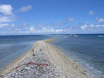 Kingman Reef, U.S. Minor Outlying Islands, the smallest county or county-equivalent by land area in the United States
 Falls Church, Virginia, the smallest county-equivalent in the 50 states by land area
Smallest, largest and average area per state and territory
The following is a list of counties and county-equivalents showing the average size of each state/territory’s counties, the smallest county (or equivalent) in each state/territory, and the largest county (or equivalent) in each state/territory. States/territories on the list are arranged by the average land area of their counties. Though not on the list, the North Slope Borough is the largest independently incorporated county equivalent. The Unorganized Borough is substantially larger, but is an extension of the State of Alaska government and not independently incorporated.[A]
Also note that the smallest land area with county-level governance in the U.S. is Falls Church, Virginia, but it is an independent city and not a county or part of one. Kingman Reef is the smallest county-equivalent in all U.S. territory (though it has no government). Kalawao County, Hawaii is the smallest true county by land area.
| State federal district or territory |
Avg. county land area, sq. mi. (km2) | Smallest county | Area, sq. mi. (km2) | Largest county | area, sq. mi. (km2) |
|---|---|---|---|---|---|
| The 50 states & D.C. | 1,124.09 (2,911.4)[note 11] | City of Falls Church, Virginia | 2.0 (5.2) | Yukon-Koyukuk Census Area, Alaska[note 12] | 145,505 (376,860) |
| The 50 states, D.C. & U.S. territories |
1,090.69 (2,824.9)[note 13] | Kingman Reef, U.S. Minor Outlying Islands | 0.01 (0.026) | Yukon-Koyukuk Census Area, Alaska | 145,505 (376,860) |
| 8,545.7 (22,133) | Skagway Municipality | 452.3 (1,171) | Yukon-Koyukuk Census Area | 145,505 (376,860) | |
| 7,572.9 (19,614) | Santa Cruz County | 1,236.9 (3,204) | Coconino County | 18,618.8 (48,222) | |
| 6,457.7 (16,725) | City of Carson City | 144.6 (375) | Nye County | 18,181.9 (47,091) | |
| 4,221.4 (10,933) | Hot Springs County | 2,004.0 (5,190) | Sweetwater County | 10,426.6 (27,005) | |
| 3,675.7 (9,520) | Los Alamos County | 109.1 (283) | Catron County | 6,923.6 (17,932) | |
| 2,833.4 (7,338) | Davis County | 298.7 (774) | San Juan County | 7,819.9 (20,253) | |
| 2,685.8 (6,956) | San Francisco County | 46.8 (121) | San Bernardino County | 20,056.9 (51,947) | |
| 2,666.3 (6,906) | Multnomah County | 431.3 (1,117) | Harney County | 10,133.1 (26,245) | |
| 2,599.0 (6,731) | Silver Bow County | 718.4 (1,861) | Beaverhead County | 5,541.6 (14,353) | |
| 1,927.7 (4,993) | Sagadahoc County | 253.6 (657) | Aroostook County | 6,671.3 (17,279) | |
| 1,878.3 (4,865) | Payette County | 406.8 (1,054) | Idaho County | 8,477.3 (21,956) | |
| 1,704.0 (4,413) | San Juan County | 173.9 (450) | Okanogan County | 5,267.9 (13,644) | |
| 1,619.4 (4,194) | Broomfield County | 33.0 (85) | Las Animas County | 4,772.6 (12,361) | |
| 1,301.9 (3,372) | Eddy County | 630.1 (1,632) | McKenzie County | 2,760.3 (7,149) | |
| 1,284.5 (3,327) | Kalawao County | 11.9 (31) | Hawaii County | 4,028.4 (10,434) | |
| 1,148.7 (2,975) | Clay County | 412.1 (1,067) | Meade County | 3,470.9 (8,990) | |
| 1,028.5 (2,664) | Rockwall County | 127.0 (329) | Brewster County | 6,183.7 (16,016) | |
| 915.2 (2,370) | Ramsey County | 152.2 (394) | St. Louis County | 6,247.4 (16,181) | |
| 895.3 (2,319) | Strafford County | 368.9 (955) | Coos County | 1,794.6 (4,648) | |
| 890.8 (2,307) | Marshall County | 371.0 (961) | Osage County | 2,246.3 (5,818) | |
| 826.1 (2,140) | Sarpy County | 238.9 (619) | Cherry County | 5,960.4 (15,437) | |
| 800.4 (2,073) | Union County | 243.5 (631) | Collier County | 1,998.3 (5,176) | |
| 778.7 (2,017) | Wyandotte County | 151.6 (393) | Butler County | 1,429.8 (3,703) | |
| 767.4 (1,988) | Etowah County | 534.9 (1,385) | Baldwin County | 1,589.7 (4,117) | |
| 760.1 (1,969) | New York County | 22.8 (59) | St. Lawrence County | 2,680.3 (6,942) | |
| 752.2 (1,948) | Pepin County | 231.9 (601) | Marathon County | 1,544.9 (4,001) | |
| 693.8 (1,797) | Lafayette County | 528.2 (1,368) | Union County | 1,039.2 (2,692) | |
| 681.2 (1,764) | Benzie County | 319.7 (828) | Marquette County | 1,808.4 (4,684) | |
| 675.1 (1,749) | Orleans Parish | 169.4 (439) | Vernon Parish | 1,327.9 (3,439) | |
| 667.8 (1,730) | Montour County | 130.2 (337) | Lycoming County | 1,228.5 (3,182) | |
| 658.3 (1,705) | Grand Isle County | 81.8 (212) | Windsor County | 969.3 (2,510) | |
| 653.5 (1,693) | McCormick County | 359.1 (930) | Horry County | 1,133.9 (2,937) | |
| 649.5 (1,682) | New Castle County | 426.2 (1,104) | Sussex County | 936.0 (2,424) | |
| 605.3 (1,568) | Middlesex County | 369.3 (956) | Litchfield County | 920.5 (2,384) | |
| 597.8 (1,548) | City of St. Louis | 61.9 (160) | Texas County | 1,177.2 (3,049) | |
| 572.2 (1,482) | Alcorn County | 400.0 (1,036) | Yazoo County | 922.9 (2,390) | |
| 564.2 (1,461) | Dickinson County | 380.6 (986) | Kossuth County | 972.7 (2,519) | |
| 557.1 (1,443) | Nantucket County | 44.9 (116) | Worcester County | 1,510.7 (3,913) | |
| 544.3 (1,410) | Putnam County | 160.1 (415) | McLean County | 1,183.3 (3,065) | |
| 486.2 (1,259) | Chowan County | 172.4 (447) | Robeson County | 949.2 (2,458) | |
| 464.3 (1,203) | Lake County | 227.4 (589) | Ashtabula County | 701.9 (1,818) | |
| 437.1 (1,132) | Hancock County | 82.6 (214) | Randolph County | 1,039.6 (2,693) | |
| 434.1 (1,124) | Trousdale County | 114.1 (296) | Shelby County | 763.1 (1,976) | |
| 404.5 (1,048) | City of Baltimore | 80.9 (210) | Frederick County | 660.2 (1,710) | |
| 389.4 (1,009) | Ohio County | 86.1 (223) | Allen County | 657.3 (1,702) | |
| 361.7 (937) | Clarke County | 119.2 (309) | Ware County | 892.4 (2,311) | |
| 350.2 (907) | Hudson County | 46.1 (119) | Burlington County | 798.5 (2,068) | |
| 329.1 (852) | Robertson County | 99.9 (259) | Pike County | 786.8 (2,038) | |
| 294.7 (763) | City of Falls Church | 2.0 (5.2) | Pittsylvania County | 968.9 (2,509) | |
| 210 (540) | Guam | 210 (540) | Guam | 210 (540) | |
| 206.8 (536) | Bristol County | 24.1 (62) | Providence County | 409.5 (1,061) | |
| 61.05 (158.1) | District of Columbia | 61.05 (158.1) | District of Columbia | 61.05 (158.1) | |
| 45.06 (116.7) | Cataño Municipality | 4.84 (12.5) | Arecibo Municipality | 125.95 (326.2) | |
| 44.75 (115.9) | Rota Municipality | 32.97 (85.4) | Northern Islands Municipality | 59.75 (154.8) | |
| 44.57 (115.4) | Saint John | 20 (52) | Saint Croix | 84 (220) | |
| 15.4 (40) | Rose Atoll | 0.083 (0.21) | Western District | 28.87 (74.8) | |
| 1.46 (3.8) | Kingman Reef | 0.01 (0.026) | Palmyra Atoll | 4.59 (11.9) | |
Population density
Most densely populated
Data presented below is based on U.S. Census department data from 2010.[11] Calculations are made by dividing the population by the land area. All county equivalents are included. This list includes the 50 most densely-populated counties and county-equivalents in the 50 states and District of Columbia, plus the 9 highest-density municipalities (county-equivalents) of Puerto Rico. Puerto Rico is the only U.S. territory with population densities (of county-equivalents) high enough to be on this list. Note that many of these high-density counties are coterminous with large cities (for example San Francisco and Philadelphia) or are independent cities in Virginia (as well as Baltimore and St. Louis) which are considered county-equivalents.
Least densely populated

This list was generated by dividing the population by the land area. All county equivalents are included. The list is dominated by just a few states: Alaska, Montana, and Texas together comprise about two-thirds of the entries. The Unorganized Borough is not included here as a unit, but its census areas (non-governmental entities) are. If the census areas were removed from the list, the Unorganized Borough would rank fourteenth with a density of 0.38 per square mile (0.15/km2).
The 8 uninhabited county-equivalents in the U.S. territories are listed at the top of the table — these are technically the least-densely populated counties/county-equivalents in the United States, but since they have no people, they are listed unranked.
Population density per state and territory
Data presented below is based on U.S. Census Bureau data from 2010.[11] Calculations are made by dividing the population by the land area. All county equivalents are included.
Excluding the census areas of Alaska, Lake and Peninsula Borough is the least densely populated county equivalent with 0.069/sq mi (0.027/km2).
The District of Columbia and Guam each only have one county-equivalent, so their most/least densely-populated county is the same.
| State federal district or territory |
Least densely populated county | Population density | Most densely populated county | Population density |
|---|---|---|---|---|
| Wilcox County | 13.13/sq mi (5.07/km2) | Jefferson County | 592.53/sq mi (228.78/km2) | |
| Yukon-Koyukuk Census Area | 0.03/sq mi (0.012/km2) | Anchorage Municipality | 171.19/sq mi (66.10/km2) | |
| Rose Atoll [note 14] | 0.00/sq mi (0/km2) | Western District | 1,139.00/sq mi (439.77/km2) | |
| La Paz County | 4.55/sq mi (1.76/km2) | Maricopa County | 414.89/sq mi (160.19/km2) | |
| Calhoun County | 8.53/sq mi (3.29/km2) | Pulaski County | 503.77/sq mi (194.51/km2) | |
| Alpine County | 1.59/sq mi (0.61/km2) | San Francisco County | 17,179.15/sq mi (6,632.91/km2) | |
| Hinsdale County | 0.75/sq mi (0.29/km2) | Denver County | 3,922.59/sq mi (1,514.52/km2) | |
| Litchfield County | 206.31/sq mi (79.66/km2) | Fairfield County | 1,467.18/sq mi (566.48/km2) | |
| Sussex County | 210.60/sq mi (81.31/km2) | New Castle County | 1,263.18/sq mi (487.72/km2) | |
| District of Columbia | 9,857.20/sq mi (3,805.89/km2) | District of Columbia | 9,857.20/sq mi (3,805.89/km2) | |
| Liberty County | 10.01/sq mi (3.86/km2) | Pinellas County | 3,347.50/sq mi (1,292.48/km2) | |
| Clinch County | 8.49/sq mi (3.28/km2) | DeKalb County | 2,585.72/sq mi (998.35/km2) | |
| Guam | 759.60/sq mi (293.28/km2) | Guam | 759.60/sq mi (293.28/km2) | |
| Kalawao County | 7.50/sq mi (2.90/km2) | Honolulu County | 1,586.71/sq mi (612.63/km2) | |
| Clark County | 0.55/sq mi (0.21/km2) | Ada County | 372.76/sq mi (143.92/km2) | |
| Pope County | 12.12/sq mi (4.68/km2) | Cook County | 5,495.11/sq mi (2,121.67/km2) | |
| Benton County | 21.78/sq mi (8.41/km2) | Marion County | 2,279.57/sq mi (880.15/km2) | |
| Adams County | 9.51/sq mi (3.67/km2) | Polk County | 750.51/sq mi (289.77/km2) | |
| Greeley County | 1.60/sq mi (0.62/km2) | Johnson County | 1,149.57/sq mi (443.85/km2) | |
| Hickman County | 20.23/sq mi (7.81/km2) | Jefferson County | 1,948.11/sq mi (752.17/km2) | |
| Cameron Parish | 5.32/sq mi (2.05/km2) | Orleans Parish | 2,029.41/sq mi (783.56/km2) | |
| Piscataquis County | 4.42/sq mi (1.71/km2) | Cumberland County | 337.23/sq mi (130.21/km2) | |
| Garrett County | 46.51/sq mi (17.96/km2) | City of Baltimore | 7,671.51/sq mi (2,961.99/km2) | |
| Franklin County | 102.05/sq mi (39.40/km2) | Suffolk County | 12,416.78/sq mi (4,794.15/km2) | |
| Keweenaw County | 3.99/sq mi (1.54/km2) | Wayne County | 2,974.42/sq mi (1,148.43/km2) | |
| Lake of the Woods County | 3.11/sq mi (1.20/km2) | Ramsey County | 3,341.64/sq mi (1,290.21/km2) | |
| Issaquena County | 3.40/sq mi (1.31/km2) | DeSoto County | 338.66/sq mi (130.76/km2) | |
| Worth County | 8.14/sq mi (3.14/km2) | St. Louis County | 5,157.48/sq mi (1,991.31/km2) | |
| Garfield County | 0.25/sq mi (0.097/km2) | Yellowstone County | 56.19/sq mi (21.70/km2) | |
| McPherson County | 0.63/sq mi (0.24/km2) | Douglas County | 1,574.37/sq mi (607.87/km2) | |
| Esmeralda County | 0.21/sq mi (0.081/km2) | Carson City | 382.09/sq mi (147.53/km2) | |
| Coos County | 18.41/sq mi (7.11/km2) | Hillsborough County | 457.37/sq mi (176.59/km2) | |
| Salem County | 199.10/sq mi (76.87/km2) | Hudson County | 13,731.61/sq mi (5,301.80/km2) | |
| Harding County | 0.32/sq mi (0.12/km2) | Bernalillo County | 570.76/sq mi (220.37/km2) | |
| Hamilton County | 2.81/sq mi (1.08/km2) | New York County | 69,468.42/sq mi (26,821.91/km2) | |
| Hyde County | 9.48/sq mi (3.66/km2) | Mecklenburg County | 1,755.54/sq mi (677.82/km2) | |
| Billings County | 0.68/sq mi (0.26/km2) | Cass County | 84.86/sq mi (32.76/km2) | |
| Northern Islands Municipality [note 15] | 0.00/sq mi (0/km2) | Saipan Municipality | 1,050.80/sq mi (405.72/km2) | |
| Monroe County | 32.12/sq mi (12.40/km2) | Cuyahoga County | 2,799.95/sq mi (1,081.07/km2) | |
| Cimarron County | 1.34/sq mi (0.52/km2) | Tulsa County | 1,058.14/sq mi (408.55/km2) | |
| Harney County | 0.73/sq mi (0.28/km2) | Multnomah County | 1,704.93/sq mi (658.28/km2) | |
| Cameron County | 12.83/sq mi (4.95/km2) | Philadelphia County | 11,379.49/sq mi (4,393.65/km2) | |
| Culebra Municipality | 156.40/sq mi (60.39/km2) | San Juan Municipality | 8,262.30/sq mi (3,190.09/km2) | |
| Washington County | 385.67/sq mi (148.91/km2) | Bristol County | 2,064.00/sq mi (796.91/km2) | |
| Allendale County | 25.53/sq mi (9.86/km2) | Greenville County | 574.72/sq mi (221.90/km2) | |
| Harding County | 0.47/sq mi (0.18/km2) | Minnehaha County | 209.95/sq mi (81.06/km2) | |
| Perry County | 19.08/sq mi (7.37/km2) | Davidson County | 1,243.33/sq mi (480.05/km2) | |
| Loving County | 0.12/sq mi (0.046/km2) | Dallas County | 2,718.00/sq mi (1,049.43/km2) | |
| 6 entities [note 16] | 0.00/sq mi (0/km2) | Wake Island | 39.80/sq mi (15.37/km2) | |
| Garfield County | 0.99/sq mi (0.38/km2) | Salt Lake County | 1,387.14/sq mi (535.58/km2) | |
| Essex County | 9.50/sq mi (3.67/km2) | Chittenden County | 291.74/sq mi (112.64/km2) | |
| Saint John Island | 211.80/sq mi (81.78/km2) | Saint Thomas Island | 1,649.10/sq mi (636.72/km2) | |
| Highland County | 5.59/sq mi (2.16/km2) | Alexandria City | 9,314.30/sq mi (3,596.27/km2) | |
| Garfield County | 3.18/sq mi (1.23/km2) | King County | 912.87/sq mi (352.46/km2) | |
| Pocahontas County | 9.27/sq mi (3.58/km2) | Ohio County | 419.98/sq mi (162.16/km2) | |
| Iron County | 7.80/sq mi (3.01/km2) | Milwaukee County | 3,925.95/sq mi (1,515.82/km2) | |
| Niobrara County | 0.94/sq mi (0.36/km2) | Laramie County | 34.15/sq mi (13.19/km2) |
Notes
^ A: The Unorganized Borough, Alaska, formed by the Borough Act of 1961, is a legal entity, run by the Alaska state government as an extension of State government,[12] it and the independently incorporated Unified, Home Rule, First Class and Second Class boroughs roughly correspond to parishes in Louisiana and to counties in the other 48 states.[13]
- Number produced by diving 3,141 by 50 — Note it is 3,141 and not 3,142 (because the District of Columbia is not counted)
- Number produced by dividing 3,242 by 57 (the number 57 represents the 50 states, the District of Columbia, the 5 inhabited territories, and the U.S. Minor Outlying Islands as one entity
- Swains Island is the least-populous county in the United States with a permanent human population — Swains Island is a county-equivalent
- Non-permanent human population
- The District of Columbia has only one county-equivalent: itself.
- The 2019 population estimate for the District of Columbia is 705,749.
- Guam has only one county-equivalent: itself.
- The 6 county-equivalents in the U.S. Minor Outlying Islands with zero people are Baker Island, Howland Island, Jarvis Island, Johnston Atoll, Kingman Reef and Navassa Island. The other 3 island territories in the U.S. Minor Outlying Islands have small non-permanent human populations.
- Wake Island’s population is non-permanent.
- Note: the lists below rank locations by land area — the ranking would be different if they were ranked by total area.
- If including water area, the average county size of counties and county-equivalents in the 50 states and D.C. is 1,208.38 square miles
- North Slope Borough, Alaska is the largest independently incorporated county-equivalent.
- If including water area, the average county size of counties and county-equivalents in all U.S. territory is 1,172.38 square miles
- The least-densely populated inhabited county-equivalent in American Samoa is Swains Island, which has 18.1 people per square mile.
- The least-densely populated inhabited county-equivalent in the Northern Mariana Islands is Tinian Municipality, which has 75.0 people per square mile.
- The 6 county-equivalents in the U.S. Minor Outlying Islands with zero people are Baker Island, Howland Island, Jarvis Island, Johnston Atoll, Kingman Reef and Navassa Island. The least-densely populated entity with a human population is Palmyra Atoll, which has 4.3 people per square mile.
References
- https://www.census.gov/geo/reference/codes/cou.html ‘’2010 FIPS Codes for Counties and County Equivalent Entities.’’ Census.gov. Retrieved June 2019.
- https://www2.census.gov/geo/pdfs/reference/GARM/Ch4GARM.pdf ‘’States, Counties, and Statistically Equivalent Entities (Chapter 4).’’ Census.gov. Retrieved July 6, 2018.
- https://web.archive.org/web/20151018122108/http://www.census.gov/geo/reference/ansi_statetables.html FIPS State Codes for the Outlying Areas of the United States and the Freely Associated States. [info about USMOI] (archived). U.S. Census Bureau. Retrieved June 2019.
- An Overview of County Government Archived July 8, 2008, at the Wayback Machine, National Association of Counties website, accessed January 5, 2008
- "Chapter 4: States, Counties, and Statistically Equivalent Entities". Geographic Areas Reference Manual (PDF). U.S. Department of Commerce. November 1994. p. 4-2.
- "American FactFinder". U.S. Census Bureau. Archived from the original on 2020-02-14. Retrieved 2018-12-19.
- CIA World Factbook — Palmyra Atoll. Retrieved June 2019.
- http://media1.britannica.com/eb-media/30/77730-004-369421B0.pdf ‘’American Samoa Infographic.’’ Britannica.com. Retrieved June 2019.
- "DataSet.txt". State & County QuickFacts. U.S. Census Bureau. Archived from the original on September 30, 2013. Retrieved November 16, 2012. (See "Download the DatabaseArchived 2015-08-07 at the Wayback Machine" for an explanation of this data set.)
- https://www.britannica.com/place/Kingman-Reef ‘’Kingman Reef.’’ Britannica.com. Retrieved July 7, 2018.
- "2010 Census Summary File 1: GEOGRAPHIC IDENTIFIERS". American Factfinder. US Census. Archived from the original on 8 April 2015. Retrieved 18 October 2013.
- "Alaska Statutes Title 29 Chapter 03. The Unorganized Borough". Local Government On-Line, Division of Community and Regional Affairs, Alaska Department of Commerce, Community and Economic Development. August 18, 1998. Retrieved 2008-07-17.
- "Local Government in Alaska" (PDF). Local Boundary Commission, Alaska Department of Commerce, Community and Economic Development. February 2001. Archived from the original (PDF) on 2008-07-18. Retrieved 2008-07-17.
External links
- Labor Statistics County Employment and Wages
| General | ||
|---|---|---|
| Demographics |
| |
| Economy | ||
| Geography | ||
| Name origins |
| |
| See also | ||