Pittsylvania County, Virginia
Pittsylvania County is a county located in the Commonwealth of Virginia. As of the 2010 census, the population was 63,506.[2] Chatham is the county seat.
Pittsylvania County | |
|---|---|
_(2).jpg) Pittsylvania County Courthouse | |
 Seal | |
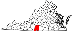 Location within the U.S. state of Virginia | |
 Virginia's location within the U.S. | |
| Coordinates: 36°49′N 79°24′W | |
| Country | |
| State | |
| Founded | 1767 |
| Named for | William Pitt |
| Seat | Chatham |
| Largest town | Hurt |
| Area | |
| • Total | 978 sq mi (2,530 km2) |
| • Land | 969 sq mi (2,510 km2) |
| • Water | 9 sq mi (20 km2) 0.9% |
| Population (2010) | |
| • Total | 63,506 |
| • Estimate (2018)[1] | 60,949 |
| • Density | 65/sq mi (25/km2) |
| Time zone | UTC−5 (Eastern) |
| • Summer (DST) | UTC−4 (EDT) |
| Congressional district | 5th |
| Website | www |
Pittsylvania County is included in the Danville, VA Micropolitan Statistical Area.[3]
The largest undeveloped uranium deposit in the United States (7th largest in the world) is located in Pittsylvania County[4] (see Uranium mining in Virginia.)
History
Originally "Pittsylvania" was a name suggested for an unrealized British colony to be located primarily in what is now West Virginia. Pittsylvania County would not have been within this proposed colony, subsequently known as Vandalia.
The county was formed in 1767 from Halifax County. It was named for William Pitt, 1st Earl of Chatham, who served as Prime Minister of Great Britain from 1766 to 1768 and opposed harsh colonial policies.
In 1777 the western part of Pittsylvania County became Patrick Henry County.
Maud Clement's History of Pittsylvania County notes the following: "Despite the settlers' intentions, towns failed to develop for two reasons: the generally low level of economic activity in the area and the competition from plantation settlements already providing the kind of marketing and purchasing services typically offered by a town. Plantation settlements along the rivers, particularly at ferrying points, became commercial centers. The most important for early Pittsylvania was that of Sam Pannill, a Scots-Irishman, who at the end of the eighteenth century, while still a young man, set up a plantation town at Green Hill on the north side of the Staunton River in Campbell County. (Clement 15)"
"Its economy was tobacco-dominated and reliant on a growing slave labor force. It was a county without towns or a commercial center. Plantation villages on the major river thoroughfares were the only centers of trade, until the emergence of Danville. (Clement 23)"
The city of Danville's history up through the antebellum period overall is an expression of the relationship between the town and the planters who influenced its development.
Geography

According to the U.S. Census Bureau, the county has a total area of 978 square miles (2,530 km2), of which 969 square miles (2,510 km2) is land and 9 square miles (23 km2) (0.9%) is water.[5] It is the largest county in Virginia by land area and second-largest by total area. The county is bounded on the north by the Roanoke River (Staunton River), intersected by the Banister River through the center, and drained by the Dan River on the south.[6]
Districts
The county is divided into seven districts:
- Banister
- Callands-Gretna
- Chatham-Blairs
- Dan River
- Staunton River
- Tunstall
- Westover
Adjacent counties and cities
Virginia Counties
- Bedford County, Virginia - Northwest (via Smith Mountain Lake)
- Campbell County, Virginia - North/Northeast
- Franklin County, Virginia - West/Northwest
- Halifax County, Virginia - East
- Henry County, Virginia - West/Southwest
Virginia Cities
- Danville, Virginia - South
North Carolina Counties
- Caswell County, North Carolina - South/Southeast
- Rockingham County, North Carolina - South/Southwest
Demographics
| Historical population | |||
|---|---|---|---|
| Census | Pop. | %± | |
| 1790 | 11,579 | — | |
| 1800 | 12,697 | 9.7% | |
| 1810 | 17,172 | 35.2% | |
| 1820 | 21,323 | 24.2% | |
| 1830 | 26,034 | 22.1% | |
| 1840 | 26,398 | 1.4% | |
| 1850 | 28,796 | 9.1% | |
| 1860 | 32,104 | 11.5% | |
| 1870 | 31,343 | −2.4% | |
| 1880 | 52,589 | 67.8% | |
| 1890 | 59,941 | 14.0% | |
| 1900 | 46,894 | −21.8% | |
| 1910 | 50,709 | 8.1% | |
| 1920 | 56,493 | 11.4% | |
| 1930 | 61,424 | 8.7% | |
| 1940 | 61,697 | 0.4% | |
| 1950 | 66,096 | 7.1% | |
| 1960 | 58,296 | −11.8% | |
| 1970 | 58,789 | 0.8% | |
| 1980 | 66,147 | 12.5% | |
| 1990 | 55,655 | −15.9% | |
| 2000 | 61,745 | 10.9% | |
| 2010 | 63,506 | 2.9% | |
| Est. 2018 | 60,949 | [1] | −4.0% |
| U.S. Decennial Census[7] 1790-1960[8] 1900-1990[9] 1990-2000[10] 2010-2013[2] | |||
According to the most recent census[11] records, there are 60,949 people, and 26,687 households residing in the county. The population density was 65.5 people per square mile (25/km²). There were 31,656 housing units at an average density of 32 per square mile (12/km²). The racial makeup of the county was 76.20% White, 21.50% Black or African American, 0.30% Native American, 0.50% Asian, 0.37% from other races, and 1.40% from two or more races. 2.70% of the population were Hispanic or Latino of any race.
There were 26,687 households out of which 30.40% had children under the age of 18 living with them. The average household size was 2.28 and the average family size was 2.93.
The median income for a household in the county was $44,356. The per capita income for the county was $23,597. About 12.60% of the population were below the poverty line.
Government
Pittsylvania County is governed by an elected seven-member Board of Supervisors. Management of the County is vested in a Board-appointed County Administrator.
| Name | Party | First Election | District | |
|---|---|---|---|---|
| Robert Warren (Chair) | Rep | 2015 | Chatham-Blairs | |
| Ronald Scearce (Vice Chair) | Rep | 2015 | Westover | |
| Joe Davis | Rep | 2015 | Dan River | |
| Tim Dudley | Rep | 2019 | Staunton River | |
| Ben Farmer | Ind | 2017 | Callands-Gretna | |
| Vic Ingram | Ind | 2019 | Tunstall | |
| Dr. Charles Miller | Ind | 2017 | Banister | |
There are also five elected Constitutional Officers:
- Clerk of the Circuit Court: Mark Scarce (I)
- Commonwealth's Attorney: Robert Bryan Haskins (R)
- Sheriff: Michael "Mike" Taylor (I)
- Commissioner of Revenue: Robin Coles-Goard (I)
- Treasurer: Vincent Shorter (I)
| Year | Republican | Democratic | Third parties |
|---|---|---|---|
| 2016 | 68.2% 21,554 | 29.1% 9,199 | 2.7% 845 |
| 2012 | 62.8% 19,263 | 35.4% 10,858 | 1.8% 560 |
| 2008 | 61.6% 18,730 | 37.5% 11,415 | 1.0% 288 |
| 2004 | 64.5% 17,673 | 33.8% 9,274 | 1.7% 470 |
| 2000 | 65.0% 15,760 | 32.3% 7,834 | 2.7% 661 |
| 1996 | 55.9% 12,127 | 35.4% 7,681 | 8.8% 1,906 |
| 1992 | 52.4% 11,467 | 35.1% 7,675 | 12.6% 2,752 |
| 1988 | 63.7% 12,229 | 34.4% 6,612 | 1.9% 360 |
| 1984 | 66.1% 15,743 | 32.7% 7,791 | 1.2% 290 |
| 1980 | 59.3% 12,022 | 37.7% 7,653 | 3.0% 605 |
| 1976 | 51.2% 9,173 | 44.3% 7,929 | 4.5% 811 |
| 1972 | 72.3% 12,108 | 26.5% 4,429 | 1.2% 200 |
| 1968 | 25.6% 5,096 | 27.3% 5,427 | 47.1% 9,367 |
| 1964 | 57.5% 7,120 | 42.3% 5,228 | 0.2% 25 |
| 1960 | 47.6% 3,788 | 51.4% 4,089 | 1.0% 77 |
| 1956 | 36.8% 2,870 | 53.1% 4,136 | 10.1% 788 |
| 1952 | 41.9% 2,893 | 57.6% 3,976 | 0.5% 31 |
| 1948 | 20.5% 1,164 | 55.6% 3,149 | 23.9% 1,353 |
| 1944 | 25.9% 1,224 | 73.9% 3,492 | 0.2% 8 |
| 1940 | 16.3% 728 | 83.3% 3,710 | 0.4% 17 |
| 1936 | 13.1% 556 | 86.8% 3,694 | 0.1% 5 |
| 1932 | 17.1% 656 | 81.4% 3,124 | 1.6% 60 |
| 1928 | 60.6% 2,598 | 39.4% 1,688 | |
| 1924 | 24.8% 880 | 72.1% 2,563 | 3.2% 113 |
| 1920 | 29.8% 1,162 | 69.7% 2,715 | 0.5% 19 |
| 1916 | 28.1% 801 | 70.5% 2,012 | 1.4% 40 |
| 1912 | 21.7% 527 | 64.2% 1,558 | 14.1% 341 |
Communities
Census-designated places
Other unincorporated communities
- Bachelors Hall
- Brosville
- Callands
- Cascade
- Chalk Level
- Climax
- Dry Fork
- Grit
- Java
- Keeling
- Markham
- Mount Airy
- Mountain Hill
- Museville
- Pickerals Crossing
- Pittsville
- Renan
- Ringgold
- Sheva
- Sonans
- Straightstone
- Sycamore
- Tightsqueeze
- Whitmell
- Whittles Depot
Unincorporated neighborhoods within incorporated towns
- Chatham
- Whittletown
- Woodlawn
- Woodlawn Heights
See also
References
- "Population and Housing Unit Estimates". Retrieved July 14, 2019.
- "State & County QuickFacts". United States Census Bureau. Archived from the original on June 7, 2011. Retrieved January 4, 2014.
- "Revised Delineations of Metropolitan Statistical Areas, Micropolitan Statistical Areas, and Combined Statistical Areas, and Guidance on Uses of the Delineations of These Areas" (PDF). Office Of Management and Budget. February 28, 2013. Retrieved February 8, 2015.
- Shulz, Max (2008, July 26). Virginia Is Sitting on the Energy Mother Lode. The Wall Street Journal. Accessed 27 July 2008.
- "US Gazetteer files: 2010, 2000, and 1990". United States Census Bureau. 2011-02-12. Retrieved 2011-04-23.
-

- "U.S. Decennial Census". United States Census Bureau. Retrieved January 4, 2014.
- "Historical Census Browser". University of Virginia Library. Retrieved January 4, 2014.
- "Population of Counties by Decennial Census: 1900 to 1990". United States Census Bureau. Retrieved January 4, 2014.
- "Census 2000 PHC-T-4. Ranking Tables for Counties: 1990 and 2000" (PDF). United States Census Bureau. Retrieved January 4, 2014.
- "U.S. Census website". United States Census Bureau. Retrieved 2011-05-14.
- "Elected Officials - Pittsylvania County, VA - Official Website". www.pittsylvaniacountyva.gov. Retrieved 20 August 2019.
- Leip, David. "Dave Leip's Atlas of U.S. Presidential Elections". uselectionatlas.org. Retrieved 2 April 2018.
External links
Places adjacent to Pittsylvania County, Virginia | |
|---|---|

| Authority control |
|
|---|