Greenville County, South Carolina
Greenville County is a county located in the state of South Carolina, in the United States. As of the 2010 census, the population was 451,225,[1] making it the most populous county in the state. In 2019, the estimated population of the county was 523,542. Its county seat is Greenville.[2] The county is also home to the Greenville County School District, the largest school system in South Carolina. County government is headquartered at Greenville County Square.
Greenville County | |
|---|---|
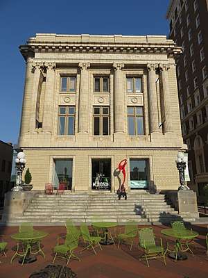 Former Greenville County Courthouse (now a bookstore and office space) | |
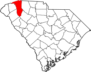 Location within the U.S. state of South Carolina | |
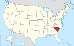 South Carolina's location within the U.S. | |
| Coordinates: 34°53′N 82°22′W | |
| Country | |
| State | |
| Founded | March 22, 1786 |
| Seat | Greenville |
| Largest city | Greenville |
| Government | |
| • County Administrator | Joseph M. Kernell |
| Area | |
| • Total | 795 sq mi (2,060 km2) |
| • Land | 785 sq mi (2,030 km2) |
| • Water | 9.7 sq mi (25 km2) 1.2%% |
| Population (2010) | |
| • Total | 451,225 |
| • Estimate (2019) | 523,542 |
| • Density | 570/sq mi (220/km2) |
| Time zone | UTC−5 (Eastern) |
| • Summer (DST) | UTC−4 (EDT) |
| Congressional districts | 3rd, 4th |
| Website | www |
Greenville County is the largest county in Upstate South Carolina. It is the central county of the Greenville-Anderson, SC Metropolitan Statistical Area, which in turn is part of the Greenville-Spartanburg-Anderson Combined Statistical Area.
Geography
According to the U.S. Census Bureau, the county has a total area of 795 square miles (2,060 km2), of which 785 square miles (2,030 km2) is land and 9.7 square miles (25 km2) (1.2%) is water.[3]
Adjacent counties
- Henderson County, North Carolina - north
- Polk County, North Carolina - northeast
- Spartanburg County - east
- Laurens County - southeast
- Abbeville County - south
- Anderson County - southwest
- Pickens County - west
- Transylvania County, North Carolina - northwest
Demographics
| Historical population | |||
|---|---|---|---|
| Census | Pop. | %± | |
| 1790 | 6,503 | — | |
| 1800 | 11,504 | 76.9% | |
| 1810 | 13,133 | 14.2% | |
| 1820 | 14,530 | 10.6% | |
| 1830 | 16,476 | 13.4% | |
| 1840 | 17,839 | 8.3% | |
| 1850 | 20,156 | 13.0% | |
| 1860 | 21,892 | 8.6% | |
| 1870 | 22,262 | 1.7% | |
| 1880 | 37,496 | 68.4% | |
| 1890 | 44,310 | 18.2% | |
| 1900 | 53,490 | 20.7% | |
| 1910 | 68,377 | 27.8% | |
| 1920 | 88,498 | 29.4% | |
| 1930 | 117,009 | 32.2% | |
| 1940 | 136,580 | 16.7% | |
| 1950 | 168,152 | 23.1% | |
| 1960 | 209,776 | 24.8% | |
| 1970 | 240,546 | 14.7% | |
| 1980 | 287,913 | 19.7% | |
| 1990 | 320,167 | 11.2% | |
| 2000 | 379,616 | 18.6% | |
| 2010 | 451,225 | 18.9% | |
| Est. 2019 | 523,542 | [4] | 16.0% |
| U.S. Decennial Census[5] 1790-1960[6] 1900-1990[7] 1990-2000[8] 2010-2015[9] | |||
As of the 2010 United States Census, there were 451,225 people, 176,531 households, and 119,362 families residing in the county.[10] The population density was 574.7 inhabitants per square mile (221.9/km2). There were 195,462 housing units at an average density of 249.0 per square mile (96.1/km2).[11] The racial makeup of the county was 73.8% white, 18.1% black or African American, 2.0% Asian, 0.3% American Indian, 0.1% Pacific islander, 3.9% from other races, and 1.9% from two or more races. Those of Hispanic or Latino origin made up 8.1% of the population.[10] In terms of ancestry, 13.0% were American, 11.6% were German, 10.9% were English, and 10.7% were Irish.[12]
Of the 176,531 households, 33.7% had children under the age of 18 living with them, 49.7% were married couples living together, 13.5% had a female householder with no husband present, 32.4% were non-families, and 27.0% of all households were made up of individuals. The average household size was 2.49 and the average family size was 3.03. The median age was 37.2 years.[10]
The median income for a household in the county was $46,830 and the median income for a family was $59,043. Males had a median income of $45,752 versus $33,429 for females. The per capita income for the county was $25,931. About 10.8% of families and 14.1% of the population were below the poverty line, including 20.0% of those under age 18 and 9.1% of those age 65 or over.[13]
| Racial composition | 2010 | 2018 |
|---|---|---|
| White | 73.8% | 76.4% |
| Black | 18.1% | 18.5% |
| Asian | 2.0% | 2.6% |
| Native American | 0.3% | 0.5% |
| Native Hawaiian and other Pacific Islander | 0.1% | 0.1% |
| Two or more races | 1.9% | 2.0% |
| Other | 3.8% | 0.0% |
2016
As of 2016 the largest self-reported ancestry groups in Greenville County, South Carolina are:[15]
| Largest ancestries (2016) | Percent |
|---|---|
| English | 12.9% |
| German | 11.0% |
| Irish | 10.2% |
| "American" | 9.9% |
| Scots-Irish | 3.1% |
| Italian | 3.1% |
| Scottish | 2.9% |
| French | 2.2% |
| Polish | 1.5% |
| Dutch | 1.2% |
| Welsh | 0.7% |
| Swedish | 0.7% |
| Norwegian | 0.6% |
Economy
CommunityWorks Federal Credit Union was chartered in 2014 to serve the residents of Greenville County. It is sponsored by CommunityWorks, Inc., a non-profit community development financial institution, and receives assistance from the United Way of Greenville County and the Hollingsworth Fund.[16]
Communities
The 2010 Census lists six cities and 16 census designated places that are fully or partially within Greenville County.[17]
Cities
- Fountain Inn (partly in Laurens County)
- Greenville
- Greer (partly in Spartanburg County)
- Mauldin
- Simpsonville
- Travelers Rest
Census-designated places
- Berea
- City View
- Dunean
- Five Forks
- Gantt
- Golden Grove
- Judson
- Parker
- Piedmont (partly in Anderson County)
- Sans Souci
- Marietta
- Taylors
- Tigerville
- Wade Hampton
- Ware Place
- Welcome
Politics
| Year | Republican | Democratic | Third parties |
|---|---|---|---|
| 2016 | 59.4% 127,832 | 34.6% 74,483 | 6.0% 12,850 |
| 2012 | 63.0% 121,685 | 35.2% 68,070 | 1.8% 3,434 |
| 2008 | 61.0% 116,363 | 37.2% 70,886 | 1.8% 3,408 |
| 2004 | 66.0% 111,481 | 32.8% 55,347 | 1.2% 2,005 |
| 2000 | 66.1% 92,714 | 31.2% 43,810 | 2.7% 3,769 |
| 1996 | 59.1% 71,210 | 34.6% 41,605 | 6.3% 7,605 |
| 1992 | 57.1% 65,066 | 30.4% 34,651 | 12.5% 14,190 |
| 1988 | 70.8% 67,371 | 28.6% 27,188 | 0.6% 567 |
| 1984 | 73.1% 66,766 | 26.4% 24,137 | 0.5% 466 |
| 1980 | 57.4% 46,168 | 40.0% 32,135 | 2.6% 2,112 |
| 1976 | 51.5% 39,099 | 47.3% 35,943 | 1.2% 939 |
| 1972 | 79.6% 46,360 | 17.4% 10,143 | 3.0% 1,726 |
| 1968 | 52.9% 31,652 | 21.6% 12,928 | 25.5% 15,241 |
| 1964 | 63.0% 29,358 | 37.0% 17,275 | |
| 1960 | 61.9% 22,657 | 38.2% 13,976 | |
| 1956 | 39.5% 10,752 | 43.5% 11,819 | 17.0% 4,622 |
| 1952 | 54.4% 17,743 | 45.6% 14,863 | |
| 1948 | 8.3% 789 | 29.0% 2,745 | 62.7% 5,940 |
| 1944 | 8.8% 711 | 87.8% 7,107 | 3.4% 276 |
| 1940 | 6.0% 514 | 94.1% 8,118 | |
| 1936 | 1.1% 92 | 98.9% 8,310 | |
| 1932 | 1.6% 126 | 98.4% 7,930 | 0.0% 2 |
| 1928 | 11.7% 546 | 88.3% 4,116 | 0.0% 2 |
| 1924 | 1.5% 59 | 97.4% 3,728 | 1.1% 42 |
| 1920 | 3.2% 144 | 96.8% 4,409 | |
| 1916 | 2.3% 81 | 96.7% 3,384 | 1.0% 36 |
| 1912 | 0.0% 0 | 98.3% 3,140 | 1.7% 55 |
| 1904 | 2.6% 66 | 97.4% 2,489 | |
| 1900 | 2.6% 47 | 97.4% 1,777 |
References
- "State & County QuickFacts". United States Census Bureau. Archived from the original on June 6, 2011. Retrieved March 17, 2015.
- "Find a County". National Association of Counties. Archived from the original on 2011-05-31. Retrieved 2011-06-07.
- "2010 Census Gazetteer Files". United States Census Bureau. August 22, 2012. Retrieved March 17, 2015.
- "Population and Housing Unit Estimates". Retrieved June 9, 2017.
- "U.S. Decennial Census". United States Census Bureau. Retrieved March 17, 2015.
- "Historical Census Browser". University of Virginia Library. Retrieved March 17, 2015.
- Forstall, Richard L., ed. (March 27, 1995). "Population of Counties by Decennial Census: 1900 to 1990". United States Census Bureau. Retrieved March 17, 2015.
- "Census 2000 PHC-T-4. Ranking Tables for Counties: 1990 and 2000" (PDF). United States Census Bureau. April 2, 2001. Retrieved March 17, 2015.
- "Greenville County, South Carolina". US Census. US Census. Archived from the original on June 6, 2011. Retrieved April 15, 2015.
- "DP-1 Profile of General Population and Housing Characteristics: 2010 Demographic Profile Data". United States Census Bureau. Archived from the original on 2020-02-13. Retrieved 2016-03-09.
- "Population, Housing Units, Area, and Density: 2010 - County". United States Census Bureau. Archived from the original on 2020-02-13. Retrieved 2016-03-09.
- "DP02 SELECTED SOCIAL CHARACTERISTICS IN THE UNITED STATES – 2006-2010 American Community Survey 5-Year Estimates". United States Census Bureau. Archived from the original on 2020-02-13. Retrieved 2016-03-09.
- "DP03 SELECTED ECONOMIC CHARACTERISTICS – 2006-2010 American Community Survey 5-Year Estimates". United States Census Bureau. Archived from the original on 2020-02-13. Retrieved 2016-03-09.
- "Greenville County, South Carolina". Census Bureau. Census Bureau. Retrieved October 2, 2016.
- "Archived copy". Archived from the original on 2020-02-13. Retrieved 2018-06-18.CS1 maint: archived copy as title (link)
- Birch, Ray (April 3, 2014). "CommunityWorks FCU Is First New CU Charter Of The Year". Credit Union Journal. Retrieved 3 April 2014.
- See http://factfinder.census.gov Archived 2020-02-12 at Archive.today for population numbers and for municipality and CDP lists in the 2010 Census.
- Leip, David. "Dave Leip's Atlas of U.S. Presidential Elections". uselectionatlas.org. Retrieved 2018-03-13.
External links
| Wikimedia Commons has media related to Greenville County, South Carolina. |
- Greenville Area Development Corporation (GADC)

- Greenville County History and Images
Places adjacent to Greenville County, South Carolina | |
|---|---|
Municipalities and communities of Greenville County, South Carolina, United States | ||
|---|---|---|
| Cities | Map of South Carolina highlighting Greenville County | |
| CDPs | ||
| Unincorporated communities | ||
| Footnotes | ‡This populated place also has portions in an adjacent county or counties | |
| Authority control |
|
|---|