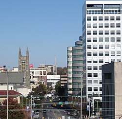
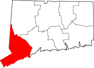
Fairfield County, Connecticut
Fairfield County is a county in the southwestern corner of the U.S. state of Connecticut, and its most populous and fastest-growing from 2010-2018.[1] As of the 2010 census, the county's population was 916,829, estimated to have increased by 3.6% to 949,921 in 2017, and decreased to 943,332 in 2019.[2] The most populous county in the state, the county population represents a little over 25% of Connecticut's overall population and is one of its fastest-growing counties. The closest to the center of the New York megacity, the county contains four of the state's largest cities–Bridgeport (1st), Stamford (3rd), Norwalk (6th), and Danbury (7th)–whose combined population of 433,368 is nearly half the county's total population.
Fairfield County | |
|---|---|
| County of Fairfield | |
 | |
 Location within the U.S. state of Connecticut | |
 Connecticut's location within the U.S. | |
| Coordinates: 41°14′N 73°22′W | |
| Country | |
| State | |
| Founded | 1666 |
| Seat | none; since 1960 Connecticut counties no longer have a county government Fairfield (1666–1853) Bridgeport (1853–1960) |
| Largest city | Bridgeport (population) Newtown (area) |
| Area | |
| • Total | 837 sq mi (2,170 km2) |
| • Land | 625 sq mi (1,620 km2) |
| • Water | 212 sq mi (550 km2) |
| Population (2010) | |
| • Total | 916,829 |
| • Estimate (2019) | 943,332 |
| • Density | 1,100/sq mi (420/km2) |
| Congressional districts | 3rd, 4th, 5th |
The United States Office of Management and Budget has designated Fairfield County as the Bridgeport-Stamford-Norwalk-Danbury metropolitan statistical area.[3] The United States Census Bureau ranked the metropolitan area as the 59th most populous metropolitan statistical area of the United States in 2019. The U.S. Office of Management and Budget has further designated the metropolitan statistical area as a component of the more extensive New York-Newark-Bridgeport, NY-NJ-CT-PA combined statistical area,[3] the most populous combined statistical area and primary statistical area of the United States.[4]
As is the case with all eight of Connecticut's counties, there is no county government and no county seat. As an area, it is only a geographical point of reference. In Connecticut, the cities and towns are responsible for all local governmental activities including fire and rescue, schools, and snow removal; in a few cases, neighboring towns will share certain resources.
Fairfield County's Gold Coast helped rank it sixth in the U.S. in per-capita personal income by the Bureau of Economic Analysis in 2005,[5] contributing substantially to Connecticut being one of the most affluent states in the U.S.[6] Other communities are more densely populated and economically diverse than the affluent areas for which the county is better known.
History
Fairfield County was the home of many Native American tribes prior to the coming of the Europeans. People of the Schaghticoke tribe lived in the area of present-day New Fairfield and Sherman.[7] From east to west the Wappinger sachemships included the Paugussetts, Tankiteke, and the Siwanoy. There were also Paquioque and Potatuck inhabitants of Fairfield County.
The Dutch explorer Adriaen Block explored coastal Connecticut in the Spring and early Summer of 1614 in the North American built vessel Onrust. The first European settlers of the county, however, were Puritans and Congregationalists from England. Roger Ludlow (1590–1664), one of the founders of the Colony of Connecticut, helped to purchase and charter the towns of Fairfield (1639) and Norwalk (purchased 1640, chartered as a town in 1651).[8] Ludlow is credited as having chosen the name Fairfield. Fairfield is a descriptive name referring to the beauty of its fields.[9] The town of Stratford was settled in 1639 as well by Adam Blakeman (1596–1665). William Beardsley (1605–1661) was also one of the first settlers of Stratford in 1639.
Fairfield County was established by an act of the Connecticut General Court in Hartford along with Hartford County, New Haven County, and New London County; which were the first four Connecticut counties, on May 10, 1666. From transcriptions of the Connecticut Colonial Records for that day:
- This Court orders that from the east bounds of Stratford
- to ye bounds of Rye shalbe for future one County wch
- shalbe called the County of Fairfield. And it is ordered
- that the County Court shalbe held at Fairfield on the second
- Tuesday in March and the first Tuesday of November
- yearely. (sic)[10]
The original Fairfield County consisted of the towns of Rye, Greenwich, Stamford, Norwalk, Fairfield, and Stratford. In 1673, the town of Woodbury was incorporated and added to Fairfield County. In 1683, New York and Connecticut reached a final agreement regarding their common border. This resulted in the cession of the town of Rye and all claims to the Oblong to New York. From the late 17th to early 18th centuries, several new towns were incorporated in western Connecticut and added to Fairfield County, namely Danbury (1687), Ridgefield (1709), Newtown (1711), and New Fairfield (1740). In 1751, Litchfield County was constituted, taking over the town of Woodbury. The final boundary adjustment to Fairfield County occurred in 1788 when the town of Brookfield was incorporated from parts of Newtown, Danbury, and New Milford, with Fairfield County gaining territory from Litchfield County.
Other early county inhabitants include:
- Joseph Hawley (born 1603 in England; died 1690), who had emigrated to America in 1629 and then settled in Stratford in 1650, later becoming Stratford's first town clerk. Joseph Hawley's son Ephraim built the Ephraim Hawley House in 1683 in Trumbull that is still standing and serves as a private residence.
- Thomas Fitch (c. 1700–1774), from Norwalk, was a governor of the Colony of Connecticut.
- Gold Selleck Silliman (1732–1790) of the town of Fairfield fought for the Americans during the American Revolutionary War and rose to the rank of Brigadier General by 1776. He fought in the New York campaign that year.
During the Revolutionary War, Connecticut's prodigious agricultural output led to it being known informally as "the Provisions State".[11] In the spring of 1777, the British Commander-in-Chief, North America General William Howe, in New York City, ordered William Tryon to interrupt the flow of supplies from Connecticut that were reaching the Continental Army. Tryon and Henry Duncan led a fleet of 26 ships carrying 2,000 men to Westport's Compo Beach to raid Continental Army supply depots in Danbury on April 22, 1777. American Major General David Wooster (1710–1777), who was born in Stratford, was in charge of the stores at Danbury and defended them with a force of only 700 troops. Sybil Ludington helped rally New York militia to aid in the defense of Danbury. The New York militia included Sybil's father Colonel Henry Ludington. Though they arrived too late to save Danbury from burning, the elder Ludington and the New York militia helped support the Danbury troops and ensuing engagement of the British known as the Battle of Ridgefield on April 27, 1777. Wooster was wounded at Ridgefield and died five days later in Danbury.
Two years later during a British raid on Greenwich on February 26, 1779 General Israel Putnam, who had stayed at Knapp's Tavern the previous night, rode away on his horse to warn the people of Stamford. Putnam was shot at by the British raiders but was able to escape. The hat he was wearing with a musket ball hole in it is on display at Knapp's Tavern in Greenwich (which is commonly, albeit somewhat erroneously, called Putnam's cottage).[12] In the summer of 1779, General William Tryon sought to punish Americans by attacking civilian targets in coastal Connecticut with a force of about 2,600 British troops. New Haven was raided on July 5, Fairfield was raided on the 7th and burned. Norwalk was raided on July 10 and burned on the 11th. Norwalk militia leader Captain Stephen Betts put up resistance to the invaders, but was overwhelmed by the powerful British raiders and was forced to retreat.
.jpg)
David Sherman Boardman (1786–1864) was a prominent early lawyer and judge in this and neighboring Litchfield County.
On October 7, 1801, Neremiah Dodge and other members of the Danbury Baptist Association wrote a letter to then-president Thomas Jefferson expressing their concern that as Baptists they may not be able to express full religious liberty in the state of Connecticut whose "ancient charter" was adopted before the establishment of a Baptist church in the state. Jefferson replied in a letter to Dodge and the other members of the Danbury church on January 1, 1802, in which he stated that the First Amendment to the United States Constitution provided "a wall of separation between church and State" that protected them.[13]
Although it is often viewed as an extension of metro-New York City, Fairfield County has had much industry in its own right. Bridgeport Machines, Inc., a milling machine manufacturer, was founded in Bridgeport in 1938. From the early to mid-20th century Bridgeport was in the top 50 largest cities by population. Stamford, Connecticut is an example of edge city urbanization, with many large and important companies having offices there and benefiting from proximity to New York.
At the height of its influence in the 1920s, the Ku Klux Klan had a distinct presence in the county and county politics. The group was most active in Darien.[14] The Klan has since disappeared from the county.
Fairfield County, along with all other Connecticut counties, was abolished as a governmental agency in accord with state legislation that took effect October 1, 1960.[15]
Geography
Land

According to the U.S. Census Bureau, the county has a total area of 837 square miles (2,170 km2), of which 625 square miles (1,620 km2) is land and 212 square miles (550 km2) (25.3%) is water.[16]
The terrain of the county trends from flat near the coast to hilly and higher near its northern extremity. The highest elevation is 1,290 feet (393 m) above sea level along the New York state line south of Branch Hill in the Town of Sherman; the lowest point is sea level itself.
The Taconic Mountains and the Berkshire Mountains ranges of the Appalachian Mountains run through Fairfield County. The Taconics begin roughly in Ridgefield and the Berkshires begin roughly in Northern Trumbull, both running north to Litchfield County and beyond. A portion of the Taconics also is in rural Greenwich and rural North Stamford in Fairfield County and run north into Westchester County, New York, eventually re-entering Fairfield County in Ridgefield. A small portion of the Appalachian Trail runs through Fairfield County; the trail enters Connecticut in the northernmost and least populous town in the county, Sherman, and moves east into Litchfield County, which encompasses the majority of the Appalachian Trail in Connecticut.
The section of the Taconic Mountains range that runs through Greenwich and North Stamford of Fairfield County is also the part of the Appalachians that is closest to the coast out of the entire Appalachian Mountains.
Water
The agreed 1684 territorial limits of the county are defined as 20 miles (32 km) east of New York's Hudson River, which extends into Long Island Sound with a southerly limit of half way to Long Island, New York. The eastern limit is mostly a natural border defined as the halfway point of the Housatonic River with New Haven County with the exception of several islands belonging wholly to Stratford. The depth of the Sound varies between 60 and 120 feet (37 m).
The county is home to the Byram River, Housatonic River, Mianus River, Mill River, Norwalk River, Pequonnock River, Rippowam River, Saugatuck River, and the Still River.
Pollution
The Still River is polluted with mercury nitrate from the hat industry in Danbury, which has flowed into the Housatonic River and into Long Island Sound.[17][18]
The Housatonic River is polluted with Monsanto chemicals called Aroclor, polychlorinated biphenyls, or PCBs. From circa 1932 until 1977, the river received PCBs pollution discharges from the General Electric plant at Pittsfield, Massachusetts.[19]
Mountains and summits
Refer to List of Mountains and Summits in Fairfield County, Connecticut.
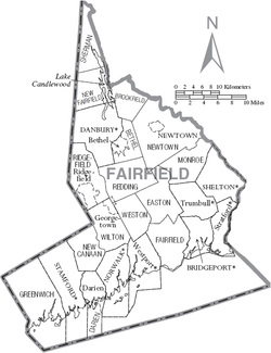
Adjacent counties
- Litchfield County (north)
- New Haven County (east)
- Westchester County, New York (southwest)
- Putnam County, New York (west)
- Dutchess County, New York (northwest)
- Nassau County, New York (south)
- Suffolk County, New York (south)
National protected areas
Demographics
| Historical population | |||
|---|---|---|---|
| Census | Pop. | %± | |
| 1790 | 36,290 | — | |
| 1800 | 38,208 | 5.3% | |
| 1810 | 41,050 | 7.4% | |
| 1820 | 42,739 | 4.1% | |
| 1830 | 47,010 | 10.0% | |
| 1840 | 49,917 | 6.2% | |
| 1850 | 59,775 | 19.7% | |
| 1860 | 77,476 | 29.6% | |
| 1870 | 95,276 | 23.0% | |
| 1880 | 112,042 | 17.6% | |
| 1890 | 150,081 | 34.0% | |
| 1900 | 184,203 | 22.7% | |
| 1910 | 245,322 | 33.2% | |
| 1920 | 320,936 | 30.8% | |
| 1930 | 386,702 | 20.5% | |
| 1940 | 418,384 | 8.2% | |
| 1950 | 504,342 | 20.5% | |
| 1960 | 653,589 | 29.6% | |
| 1970 | 792,814 | 21.3% | |
| 1980 | 807,143 | 1.8% | |
| 1990 | 827,645 | 2.5% | |
| 2000 | 882,567 | 6.6% | |
| 2010 | 916,829 | 3.9% | |
| Est. 2019 | 943,332 | 2.9% | |
| U.S. Decennial Census[20] 1790-1960[21] 1900-1990[22] 1990-2000[23] 2010-2018[1] | |||
2000 census
As of the census[24] of 2000, there were 882,567 people, 324,232 households, and 228,259 families residing in the county. The population density was 1,410 people per square mile (545/km2). There were 339,466 housing units at an average density of 542 per square mile (209/km2). The racial makeup of the county was 79.31% White, 10.01% Black or African American, 0.20% Native American, 3.25% Asian, 0.04% Pacific Islander, 4.70% from other races, and 2.49% from two or more races. 11.88% of the population were Hispanic or Latino of any race. 17.6% were of Italian, 12.4% Irish, 6.5% German and 6.4% English ancestry.
In 2010, 66.2% of Fairfield County's population was non-Hispanic whites and 10.8% of the population was black. Asians were 4.6% of the population. Hispanics now constituted 16.9% of the population.[25]
As of 2000, 76.2% spoke English, 11.0% Spanish, 2.0% Portuguese, 1.7% Italian and 1.1% French as their first language. Some of the last group were Haitians, although other Haitians would identify Haitian creole as their first language.
There were 324,232 households, out of which 34.20% had children under the age of 18 living with them, 55.50% were married couples living together, 11.50% had a female householder with no husband present, and 29.60% were non-families. 24.00% of all households were made up of individuals, and 9.40% had someone living alone who was 65 years of age or older. The average household size was 2.67 and the average family size was 3.18.
In the county, the population was spread out, with 25.60% under the age of 18, 7.00% from 18 to 24, 30.90% from 25 to 44, 23.30% from 45 to 64, and 13.30% who were 65 years of age or older. The median age was 37 years. For every 100 females, there were 93.40 males. For every 100 females age 18 and over, there were 89.60 males.
The median income for a household in the county was $65,249, and the median income for a family was $77,690. Males had a median income of $51,996 versus $37,108 for females. The per capita income for the county was $38,350. About 5.00% of families and 6.90% of the population were below the poverty line, including 8.30% of those under age 18 and 6.60% of those age 65 or over.
2010 census
As of the 2010 United States Census, there were 916,829 people, 335,545 households, and 232,896 families residing in the county.[26] The population density was 1,467.2 inhabitants per square mile (566.5/km2). There were 361,221 housing units at an average density of 578.1 per square mile (223.2/km2).[27] The racial makeup of the county was 74.8% white, 10.8% black or African American, 4.6% Asian, 0.3% American Indian, 6.8% from other races, and 2.6% from two or more races. Those of Hispanic or Latino origin made up 16.9% of the population.[26] In terms of ancestry, 18.1% were Italian, 15.9% were Irish, 9.8% were German, 8.7% were English, 5.5% were Polish, and 2.7% were American.[28]
Of the 335,545 households, 36.4% had children under the age of 18 living with them, 53.1% were married couples living together, 12.3% had a female householder with no husband present, 30.6% were non-families, and 24.9% of all households were made up of individuals. The average household size was 2.68 and the average family size was 3.21. The median age was 39.5 years.[26]
The median income for a household in the county was $81,268 and the median income for a family was $100,593. Males had a median income of $70,187 versus $50,038 for females. The per capita income for the county was $48,295. About 5.6% of families and 8.0% of the population were below the poverty line, including 9.4% of those under age 18 and 6.4% of those age 65 or over.[29]
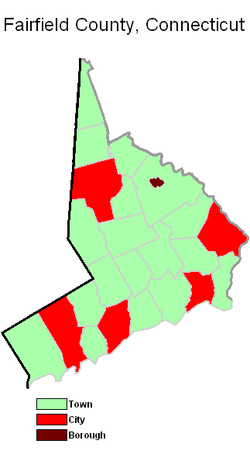
Demographic breakdown by town
Income
Data is from the 2010 United States Census and the 2006-2010 American Community Survey 5-Year Estimates.[30][31]
| Town | Per capita income |
Median household income |
Median family income |
Population | Number of households | |
|---|---|---|---|---|---|---|
| Bethel | Town | $36,608 | $83,483 | $99,568 | 18,584 | 6,938 |
| Bridgeport | City | $19,854 | $41,047 | $47,894 | 144,229 | 51,255 |
| Brookfield | Town | $58,715 | $119,370 | $136,682 | 17,550 | 6,427 |
| Danbury | City | $31,461 | $65,275 | $74,420 | 80,893 | 28,907 |
| Darien | Town | $95,577 | $175,766 | $211,313 | 20,732 | 6,698 |
| Easton | Town | $63,405 | $140,370 | $163,194 | 7,490 | 2,577 |
| Fairfield | Town | $55,733 | $113,248 | $138,067 | 59,404 | 20,457 |
| Greenwich | Town | $92,759 | $124,958 | $167,825 | 61,171 | 23,076 |
| Monroe | Town | $43,842 | $109,727 | $119,357 | 19,479 | 6,735 |
| New Canaan | Town | $100,824 | $179,338 | $220,278 | 19,738 | 7,010 |
| New Fairfield | Town | $39,486 | $101,067 | $108,720 | 13,881 | 4,802 |
| Newtown | Town | $45,308 | $108,148 | $120,507 | 27,560 | 9,459 |
| Newtown | Borough | $43,916 | $106,141 | $109,821 | 1,941 | 696 |
| Norwalk | City | $43,303 | $76,161 | $93,009 | 85,603 | 33,217 |
| Redding | Town | $65,594 | $130,557 | $145,833 | 9,158 | 3,470 |
| Ridgefield | Town | $72,026 | $132,907 | $166,036 | 24,638 | 8,801 |
| Sherman | Town | $48,637 | $115,417 | $129,177 | 3,581 | 1,388 |
| Shelton | City | $38,341 | $80,656 | $97,211 | 39,559 | 15,325 |
| Stratford | Town | $32,590 | $67,530 | $83,369 | 51,384 | 20,095 |
| Stamford | City | $44,667 | $75,579 | $88,050 | 122,643 | 47,357 |
| Trumbull | Town | $44,006 | $102,059 | $117,855 | 36,018 | 12,725 |
| Weston | Town | $92,735 | $209,630 | $242,361 | 10,179 | 3,379 |
| Westport | Town | $90,792 | $150,771 | $182,659 | 26,391 | 9,573 |
| Wilton | Town | $78,234 | $153,770 | $181,763 | 18,062 | 6,172 |
Race
Data is from the 2007-2011 American Community Survey 5-Year Estimates, ACS Demographic and Housing Estimates, "Race alone or in combination with one or more other races."[32]
| Rank | Town | Population | White | Black | Asian | American Indian |
Other | Hispanic | |
|---|---|---|---|---|---|---|---|---|---|
| 1 | Bridgeport | City | 143,412 | 49.8% | 35.9% | 3.9% | 0.6% | 11.8% | 36.7% |
| 2 | Stamford | City | 121,784 | 61.0% | 15.5% | 8.7% | 0.3% | 16.3% | 24.4% |
| 3 | Norwalk | City | 85,145 | 77.2% | 14.0% | 4.3% | 0.6% | 6.0% | 20.2% |
| 4 | Danbury | City | 80,101 | 74.2% | 8.7% | 6.5% | 1.2% | 13.0% | 25.1% |
| 5 | Greenwich | Town | 61,023 | 87.1% | 2.3% | 7.6% | 0.2% | 3.9% | 9.0% |
| 6 | Fairfield | Town | 59,078 | 92.9% | 1.8% | 5.0% | 0.2% | 1.4% | 4.4% |
| 7 | Stratford | Town | 51,116 | 79.5% | 14.2% | 3.7% | 0.5% | 4.1% | 15.3% |
| 8 | Shelton | City | 39,310 | 92.6% | 2.0% | 2.5% | 0.3% | 3.1% | 7.1% |
| 9 | Trumbull | Town | 35,752 | 91.9% | 2.4% | 5.4% | 0.2% | 1.5% | 6.0% |
| 10 | Newtown | Town | 27,235 | 92.7% | 2.0% | 3.4% | 0.5% | 3.0% | 6.0% |
| 11 | Westport | Town | 26,249 | 93.3% | 1.4% | 5.4% | 0.1% | 1.5% | 3.6% |
| 12 | Ridgefield | Town | 24,469 | 96.0% | 1.0% | 3.2% | 0.3% | 0.7% | 3.2% |
| 13 | Darien | Town | 20,580 | 95.2% | 0.8% | 3.8% | 0.1% | 1.3% | 3.7% |
| 14 | New Canaan | Town | 19,642 | 96.4% | 1.0% | 2.5% | 0.3% | 0.8% | 1.8% |
| 15 | Monroe | Town | 19,398 | 96.9% | 0.2% | 2.4% | 0.1% | 0.7% | 4.5% |
| 16 | Bethel | Town | 18,584 | 90.5% | 2.5% | 5.1% | 0.4% | 3.5% | 7.6% |
| 17 | Wilton | Town | 17,973 | 93.2% | 1.2% | 5.7% | 0.0% | 1.0% | 2.8% |
| 18 | Brookfield | Town | 16,339 | 92.0% | 1.6% | 6.1% | 0.4% | 0.9% | 4.4% |
| 19 | New Fairfield | Town | 13,847 | 95.3% | 0.6% | 0.9% | 0.6% | 3.6% | 6.5% |
| 20 | Weston | Town | 10,142 | 96.1% | 1.7% | 3.0% | 0.6% | 0.8% | 2.9% |
| 21 | Redding | Town | 9,058 | 95.7% | 1.8% | 2.8% | 2.1% | 0.3% | 2.6% |
| 22 | Easton | Town | 7,452 | 96.7% | 1.3% | 2.5% | 0.0% | 0.0% | 2.2% |
| 23 | Sherman | Town | 3,598 | 100.0% | 0.0% | 0.0% | 0.0% | 0.0% | 1.6% |
| 24 | Newtown | Borough | 2,035 | 97.7% | 0.8% | 2.0% | 0.9% | 0.5% | 2.7% |
Economy
In the late 1960s and early 1970s corporations began moving their headquarters to Fairfield County from Manhattan; Thomas J. Lueck of The New York Times said that the trend "permanently decentralized big business in the New York region." During the 1980s many buyouts and reorganizations and an economic recession lead to companies vacating much of the suburban office space in Fairfield County. In 1992 Fairfield County had the headquarters of over 25 major multinational corporations, giving it the third largest concentration of those companies in the United States after New York City and Chicago.[33]
Recently, Fairfield County has been described as a "hedge fund ghetto" due to the large concentration of investment management firms in the area, most notably Bridgewater Associates (one of the world's largest hedge fund companies), Aladdin Capital Management and Point72 Asset Management.
Government and municipal services
As of 1960, counties in Connecticut do not have any associated county government structure. Thus Fairfield County is only a geographical point of reference. All municipal services are provided by the towns, who sometimes will share certain resources through regionalization. In order to address issues concerning more than one town, several regional agencies that help coordinate the towns for infrastructure, land use, and economic development concerns have been established. Within the geographical area of Fairfield County, the regional agencies are:
- Greater Bridgeport
- South Western
- The Valley (partly in New Haven County)
- Housatonic Valley (partly in Litchfield County)
County municipal buildings
Several former county municipal buildings are used by other state or local agencies, including:
- The Fairfield County Jail in Bridgeport on the corner of North Avenue and Madison Avenue, still actively used to house prisoners.
- The Fairfield County Court Houses in Bridgeport and Danbury which served the county's judicial needs and housed county deputy sheriff's until December 2000. The court houses are still marked "Fairfield County Court House".
Law enforcement
Law enforcement within the geographic area of the county is provided by the respective town police departments, whereas in other states in the region such as New York and Vermont law enforcement would be provided by the local county sheriff's department. In the less dense areas, such as Sherman, law enforcement is primarily provided by the Connecticut State Police. Prior to 2000, a County Sheriff's Department existed for the purpose of executing judicial warrants, prisoner transport, court security, Bailiff, and county and state executions. These responsibilities have now been taken over by the Connecticut State Marshal System.
Some municipalities in the county still maintain a sheriff's department to fill the void of the abolishment of the county sheriff's department, such as the City of Shelton which has established the Shelton Sheriff's Department to carry out warrants in the city.
Judicial
The geographic area of the county is served by the three separate judicial districts: Danbury, Stamford-Norwalk, and Fairfield. Each judicial district has a superior court located, respectively, in Danbury, Stamford, and Bridgeport. Each judicial district has one or more geographical area courts ("GA"'s), subdivisions of the judicial districts that handle lesser cases such as criminal misdemeanors, small claims, traffic violations, and other civil actions.
Fire protection
Fire protection in the county is provided by the towns. Several towns also have fire districts that provide services to a section of the town.
Education
Education in the county is usually provided by the town governments. The exceptions are the towns of Redding and Easton, which joined together to form a regional school district (Region 9).
Crime Rate
Fairfield County has a low crime index of 2050.2 (per 100,000 citizens) as well as a murder closure rate of over 70%.[34] Several Governmental agencies, as well as private security contractors, have made note of Fairfield's low crime rates and the County currently has 6 cities and towns with a percentile safety index of 90% or higher compared to the rest of the continental United States (based on violent and property crimes).[35]
Politics
Like many urban counties, Fairfield county runs democratic. The last time the county voted for a Republican presidential candidate was in 1992 for George H.W Bush.
| Year | GOP | DEM | Others |
|---|---|---|---|
| 2016 | 38.0% 160,077 | 57.9% 243,852 | 4.1% 17,280 |
| 2012 | 44.2% 175,168 | 54.9% 217,294 | 0.9% 3,668 |
| 2008 | 40.5% 167,736 | 58.7% 242,936 | 0.7% 3,069 |
| 2004 | 47.3% 189,605 | 51.4% 205,902 | 1.4% 5,460 |
| 2000 | 43.1% 159,659 | 52.3% 193,769 | 4.6% 16,861 |
| 1996 | 41.1% 144,632 | 48.9% 172,337 | 10.0% 35,258 |
| 1992 | 42.8% 175,158 | 39.1% 160,202 | 18.1% 74,050 |
| 1988 | 59.0% 221,316 | 39.9% 149,630 | 1.1% 3,932 |
| 1984 | 65.8% 257,319 | 33.8% 132,253 | 0.4% 1,607 |
| 1980 | 54.9% 201,997 | 33.7% 124,074 | 11.4% 42,027 |
| 1976 | 58.2% 209,458 | 41.2% 148,353 | 0.7% 2,413 |
| 1972 | 64.0% 233,188 | 34.3% 125,128 | 1.7% 6,050 |
| 1968 | 51.8% 173,108 | 41.7% 139,364 | 6.5% 21,820 |
| 1964 | 39.2% 125,576 | 60.8% 194,782 | 0.1% 261 |
| 1960 | 53.4% 167,778 | 46.6% 146,442 | 0.0% 6 |
| 1956 | 70.2% 199,841 | 29.8% 84,890 | 0.0% 0 |
| 1952 | 60.7% 167,278 | 38.6% 106,403 | 0.7% 1,812 |
| 1948 | 54.7% 118,636 | 41.8% 90,767 | 3.5% 7,669 |
| 1944 | 50.5% 103,693 | 48.3% 99,181 | 1.2% 2,423 |
| 1940 | 49.1% 91,190 | 50.5% 93,688 | 0.5% 829 |
| 1936 | 41.6% 67,846 | 53.5% 87,329 | 5.0% 8,088 |
| 1932 | 49.9% 72,238 | 44.5% 64,367 | 5.6% 8,092 |
| 1928 | 55.8% 71,410 | 43.4% 55,491 | 0.8% 1,047 |
| 1924 | 66.2% 58,041 | 21.5% 18,815 | 12.3% 10,788 |
| 1920 | 66.5% 55,251 | 29.8% 24,761 | 3.7% 3,101 |
| 1916 | 53.8% 25,962 | 43.2% 20,873 | 3.0% 1,442 |
| 1912 | 31.5% 13,147 | 37.6% 15,663 | 30.9% 12,893 |
| 1908 | 59.0% 24,064 | 36.6% 14,917 | 4.4% 1,812 |
| 1904 | 58.2% 23,490 | 39.2% 15,796 | 2.6% 1,063 |
| 1900 | 57.1% 21,317 | 41.4% 15,455 | 1.5% 560 |
| 1896 | 67.9% 24,489 | 27.0% 9,726 | 5.1% 1,848 |
| 1892 | 48.4% 16,190 | 48.2% 16,125 | 3.5% 1,156 |
| 1888 | 49.6% 15,549 | 47.8% 14,984 | 2.7% 848 |
| 1884 | 48.3% 13,694 | 49.2% 13,964 | 2.5% 718 |
Hospitals
Transportation
Mass transit
With Interstate 95 and the Merritt Parkway increasingly clogged with traffic, state officials are looking toward mass transit to ease the county's major thoroughfares' traffic burden.
New office buildings are being concentrated near railroad stations in Stamford, Bridgeport and other municipalities in the county to allow for more rail commuting. Proximity to Stamford's Metro-North train station was cited by the Royal Bank of Scotland as a key reason for locating its new U.S. headquarters building in downtown Stamford; construction on the office tower started in late 2006.
Air
Within Fairfield County there are two regional airports: Igor I. Sikorsky Memorial Airport in Stratford and the Danbury Municipal Airport in Danbury. The county is also served by larger airports such as Bradley International Airport, John F. Kennedy International Airport, LaGuardia Airport, Newark Liberty International Airport, Tweed New Haven Regional Airport, and Westchester County Airport.
Bus service
Connecticut Transit's Stamford division runs local and inter-city buses to the southern part of the county.[37] The Norwalk Transit District serves the Norwalk area in the southern central portion of the county; the Greater Bridgeport Transit Authority serves Bridgeport and eastern Fairfield County; and the Housatonic Area Regional Transit agency serves Danbury and the northern portions of the county.
Ferry service
The Bridgeport & Port Jefferson Ferry carries passengers and cars from Bridgeport to Port Jefferson, New York across Long Island Sound.
Ferry lines in and out of Stamford are also in development.
Rail
Commuter Rail is perhaps Fairfield County's most important transportation artery, as it allows its residents an efficient ride to Grand Central Terminal in New York City. Service is provided on Metro-North's New Haven Line, and every town on the shoreline has at least one station. Connecting lines bring service to New Canaan from Stamford on the New Canaan Branch, and to Danbury from South Norwalk on the Danbury Branch. Many trains run express from New York to Stamford, making it an easy 45-minute ride.
In the 2005 and 2006 sessions of the Legislature, massive appropriations were made to buy replacements for the 343 rail cars for the Metro-North New Haven Line and branch lines. The approximately 30-year-old cars will be replaced with new cars at a rate of ten per month starting in 2010.[38]
Bridgeport and Stamford are also served by Amtrak, and both cities see a significant number of boardings on the "Regional Northeast Route" (Boston to Newport News, VA). This route also serves other Amtrak stations in Connecticut, including New Haven, Old Saybrook, New London, and Mystic.
Major roads
Boston Post Road
U.S. 1 is the oldest east-west route in the county, running through all of its shoreline cities and towns. Known by various names along its length, most commonly "Boston Post Road" or simply "Post Road", it gradually gains latitude from west to east. Thus U.S. 1 west is officially designated "South" and east is "North".
Though contiguous, U.S.1 changes name by locality. In Greenwich it is Putnam Avenue. In Stamford it becomes Main Street or Tresser Boulevard. In Darien it is Boston Post Road or "the Post Road". In Norwalk it is Connecticut Avenue in the west, Van Zant St, Cross St, and North Av in the center, and Westport Avenue in the east. In Westport, it is Post Road West from the Norwalk town line until the Saugatuck River and then it becomes Post Road East until Fairfield. In Fairfield it is again Boston Post Road or "the Post Road". In Bridgeport it follows Kings Highway in the west, North Avenue in the center, and Boston Avenue in the east. Finally, it becomes Barnum Avenue in Stratford.
Interstate 95
The western portions of Interstate 95 in Connecticut are known as the Connecticut Turnpike or the Governor John Davis Lodge Turnpike in Fairfield County and it crosses the state approximately parallel to U.S. Route 1. The road is most commonly referred to as "I-95". The highway is six lanes (sometimes eight lanes) throughout the county. It was completed in 1958 and is often clogged with traffic particularly during morning and evening rush hours.
With the cost of land so high along the Gold Coast, state lawmakers say they don't consider widening the highway to be fiscally feasible, although occasional stretches between entrances and nearby exits are now sometimes connected with a fourth "operational improvement" lane (for instance, westbound between the Exit 10 interchange in Darien and Exit 8 in Stamford). Expect similar added lanes in Darien and elsewhere in the Fairfield County portion of the highway in the future, lawmakers and state Department of Transportation officials say.
Merritt Parkway
The Merritt Parkway, also known as "The Merritt" or Connecticut Route 15, is a truck-free scenic parkway that runs through the county parallel and generally several miles north of Interstate 95. It begins at the New York state line where it is the Hutchinson River Parkway and terminates on the Igor I. Sikorsky Memorial Bridge where it becomes the Wilbur Cross Parkway at the New Haven county line.
The interchange between the Merritt Parkway and Route 7 in Norwalk was completed around the year 2000. The project was held up in a lawsuit won by preservationists concerned about the historic Merritt Parkway bridges. It is now exit 39 off the Merritt, and exit 15 off I-95. The parkway is a National Scenic Byway and is listed on the National Register of Historic Places.[39]
Interstate 84
Interstate 84, which runs through Danbury, is scheduled to be widened to a six-lane highway at all points between Danbury and Waterbury. State officials say they hope the widening will not only benefit drivers regularly on the route but also entice some cars from the more crowded Interstate 95, which is roughly parallel to it. Heavier trucks are unlikely to use Interstate 84 more often, however, because the route is much hillier than I-95 according to a state Department of Transportation official.
U.S. Route 7
With its southern terminus at Interstate 95 in central Norwalk, U.S. Route 7 heads north through Wilton, Ridgefield, and Danbury to points north. In Danbury and almost all of Norwalk, the route is a highway (known as "Super 7" in the Danbury area or "The Connector" in Norwalk) but it becomes a four-lane road just south of the Wilton-Norwalk border and up to Danbury. There is significant opposition to making the route a limited access highway for the entire length by residents of Wilton and Ridgefield. As a compromise between freeway supporters and opponents, the Connecticut Department of Transportation is upgrading the existing 2-lane section to 4 lanes, with a median in some locations. The state has also bypassed the original 2-lane Route 7 around Brookfield with a freeway, where town officials have long supported an expressway to divert traffic away from the town center.
Connecticut Route 8
Route 8 terminates in downtown Bridgeport from I-95 with Connecticut Route 25 and goes north. It splits from Connecticut Route 25 at the Bridgeport—Trumbull town line and continues north into southeastern Trumbull and Shelton, then beyond the county through some of towns of the Naugatuck River Valley to Waterbury and beyond. Construction of the route provided some impetus for the creation of office parks in Shelton and home construction there and in other parts of The Valley.
Connecticut Route 25
Route 25 starts in downtown Bridgeport from I 95 with Route 8 and goes north. It splits from Connecticut Route 8 at the Bridgeport—Trumbull town line and continues into Trumbull. The limited access divided expressway ends in northern Trumbull, but Route 25 continues into Monroe, Newtown, and Brookfield.
Sports
Teams that previously called Fairfield County their home include the Connecticut Wildcats[40] of USA Rugby League, the Danbury Whalers[41] and the Danbury Titans[42] of the Federal Hockey League, and the Bridgeport Bluefish in baseball's independent Atlantic League.[43] In addition, being a part of metropolitan New York City, the major professional sports teams of New York State and New Jersey are local teams to Connecticut.
Communities
Note: Villages are named localities within towns, but have no separate corporate existence from the towns they are in.
|
|
|
Telephone area codes
All communities in the county are in the area code 203/area code 475 overlay except for the town of Sherman which is in area code 860 and part of the geographical New Milford telephone exchange.
Major media in the county
Countywide
- Fairfield County Weekly
Daily newspapers covering the county
Published within the county
- The Advocate of Stamford - Stamford edition, published by Southern Connecticut Newspapers Inc., a subsidiary of the Tribune Company.
- The Advocate of Stamford - Norwalk edition
- Connecticut Post, owned by Media General Group, published in Bridgeport.
- Greenwich Time, published by Southern Connecticut Newspapers Inc., a subsidiary of the Tribune Company.
- The Hour (registration required), controlled by a trust under the ultimate authority of Norwalk Probate Court.
- The News-Times of Danbury, owned by Ottaway Newspapers, a subsidiary of Dow Jones.
- The Fairfield County Business Journal, published by Westfair Communications Inc.
- The Newtown Bee published in Newtown.
Spanish language newspapers
- El Sol News, countywide, based in Stamford.
- El Canillita, distributed across southwestern Connecticut.
- Pluma Libre, distributed across southwestern Connecticut.
Broadcast media and cable television
- News 12 Connecticut has studios in Norwalk and covers Fairfield County as well as statewide news from Hartford.
- WFSB from Hartford maintains a secondary feed for Fairfield County on their fourth subchannel which is carried by area cable providers; it mainly offers differing advertising for local businesses, along with a different programming schedule to address syndicated programming which is claimed by New York City stations and would otherwise be blacked out on WFSB.
Colleges
- Housatonic Community College in Bridgeport
- University of Bridgeport in Bridgeport
- University of Connecticut Stamford campus
- Fairfield University in Fairfield
- Norwalk Community College
- St. Vincent's College in Bridgeport
- Sacred Heart University in Fairfield
- Western Connecticut State University in Danbury
- Lincoln Technical Institute in Shelton
Culture and the arts
Fine Arts
- Franklin Street Works located in the downtown area of Stamford, Connecticut.
- The Housatonic Museum of Art located at Housatonic Community College in Bridgeport, Connecticut.
Music: orchestras in the county
- Greater Bridgeport Symphony. Founded in 1945, its concerts are held at Klein Memorial Auditorium in Bridgeport. The orchestra offers a free outdoors pops concert in the summer at Fairfield University. Gustav Meier has been with the GBSO for 41 years.
- Connecticut Grand Opera, a not-for-profit, professional opera company founded in 1993 and based in Stamford, where it performs at the Palace Theatre. On its web site, the CGO claims to offer "the most ambitious opera season of any company between New York and Boston."
- Danbury Symphony Orchestra. This orchestra does not have its own Web site and only part of a web page at the Danbury Music Center web site is devoted to it.
- Greenwich Symphony Orchestra. Begun in 1958 as the Greenwich Philharmonia, the orchestra has grown to 90 members who perform at the Dickerman Hollister Auditorium at Greenwich High School. It also performs a pops concert in the summer. David Gilbert has been music director and conductor since 1975.
- Norwalk Symphony Orchestra. Its concerts take place in a graceful, large "Norwalk Concert Hall" auditorium of Norwalk City Hall. Founded in 1939, the NSO remained primarily a community orchestra of volunteers. In 1956, the Norwalk Youth Symphony was created, and younger musicians often were invited to be part of the orchestra. Diane Wittry has been music director and conductor since 2002. For the past eight years she has held the same title at the Allentown Symphony Orchestra in Pennsylvania.
- Ridgefield Symphony Orchestra. Annually, the RSO presents four subscription concerts at the Anne S. Richardson Auditorium at Ridgefield High School, and two chamber music concerts at the Ridgefield Playhouse for the Performing Arts (only one is scheduled in the 2006–07 season), along with an annual "family concert" and performances in Ridgefield schools.
- Stamford Symphony Orchestra The SSO typically gives five pairs of classical concerts and three pops concerts a season at the 1,586-seat Palace Theatre. It also performs a concert for elementary school students and a family concert series.
- Western Connecticut Youth Orchestra, a not-for-profit organization providing talented young musicians in the Fairfield County and Upper Westchester County areas with a classical symphony experience.
Other music and arts events
- The Barnum Festival has been held in the Spring in Bridgeport since 1949 to raise money for charity.
- The Connecticut Film Festival is held in the Spring in Danbury.
- The Fairfield County Freestyle Championships are generally held once a semester on the campus of Sacred Heart University. This event showcases the best freestyle dancers and rappers that live, work, or go to school in Fairfield County. The event is sponsored by the SHU Freestyle Club.
- The Gathering of the Vibes musical event has been held in Bridgeport's Seaside Park in 1999, 2000, 2007, and again in 2008.
- Musicals at Richter, held every summer in Danbury, is Connecticut's longest running outdoor theater
- The Norwalk Oyster Festival is an annual fair in the city of Norwalk that features craft vendors and live music performances. The festival takes place on the first weekend after Labor Day in Veterans Park, near Long Island Sound.
See also
- Historical U.S. Census Totals for Fairfield County, Connecticut
- List of Mountains and Summits in Fairfield County, Connecticut
- List of Registered Historic Places in Fairfield County, Connecticut
References
- "QuickFacts Connecticut; Fairfield County, Connecticut". U.S. Census Bureau. March 31, 2018.
- "ACS 2018 Demographic and Housing Estimates". data.census.gov. Retrieved February 2, 2020.
- "OMB Bulletin No. 13-01: Revised Delineations of Metropolitan Statistical Areas, Micropolitan Statistical Areas, and Combined Statistical Areas, and Guidance on Uses of the Delineations of These Areas" (PDF). United States Office of Management and Budget. February 28, 2013. Retrieved March 20, 2013.
- "Annual Estimates of the Resident Population: April 1, 2010 to July 1, 2015 – Combined Statistical Area; and for Puerto Rico – 2015 Population Estimates". U.S. Census Bureau. Archived from the original on February 13, 2020. Retrieved October 29, 2016.
- See "BEA : CA1-3 - Per capita personal income". Archived from the original on September 29, 2007. Retrieved September 23, 2008.
- The Connecticut Economy Fall 2008 Archived July 20, 2011, at the Wayback Machine
- Simon, Irving B. (1975). Our Town: The History of New Fairfield. New Fairfield, Connecticut: New Fairfield Bicentennial Commission. p. 5.
- Richard Somerset-Ward (June 11, 2005). An American theatre: the story of Westport Country Playhouse, 1931-2005. Yale University Press. p. 24. ISBN 978-0-300-10648-0. Retrieved November 21, 2011.
- Gannett, Henry (1905). The Origin of Certain Place Names in the United States. Govt. Print. Off. p. 123.
- The public records of the colony of Connecticut, from 1665 to 1678. 02. 1850. p. 35. Retrieved July 22, 2013.
- "SOTS: Sites, Seals & Symbols". State of Connecticut Secretary of the State. Archived from the original on July 31, 2008. Retrieved June 12, 2008.
- "Greenwich Connecticut History". Archived from the original on June 28, 2008. Retrieved June 15, 2008.
- Letter to Danbury Baptist Association, CT, January 1, 1802
- DiGiovanni, the Rev. (now Monsignor) Stephen M., The Catholic Church in Fairfield County: 1666-1961, 1987, William Mulvey Inc., New Canaan, Chapter II: The New Catholic Immigrants, 1880-1930; subchapter: "The True American: White, Protestant, Non-Alcoholic," pp. 81-82; DiGiovanni, in turn, cites (Footnote 209, page 258) Jackson, Kenneth T., The Ku Klux Klan in the City, 1915-1930 (New York, 1981), p. 239
- "SOTS: Section VI - Counties - Table of Contents". State of Connecticut, Secretary of the State. Archived from the original on November 27, 2011. Retrieved June 16, 2008.
- "US Gazetteer files: 2010, 2000, and 1990". United States Census Bureau. February 12, 2011. Retrieved April 23, 2011.
- Varekamp, JC; Buchholtz ten Brink, MR; Mecray, EL; Kreulen, B (Summer 2000). "Mercury in Long Island Sound Sediments". Journal of Coastal Research. 16 (3): 613–626. JSTOR 4300074.
- Lerman-Sinkoff, Sarah. "Transport and Fate of Historic Mercury Pollution from Danbury, CT through the Still and Housatonic Rivers". Wesleyan University. Wesleyan University. Retrieved September 30, 2015.
- U.S. Environmental Protection Agency (EPA). Boston, MA. GE/Housatonic River Site in New England: Site History and Description." Archived May 19, 2011, at the Wayback Machine 2009-11-12.
- "U.S. Decennial Census". United States Census Bureau. Retrieved June 11, 2014.
- "Historical Census Browser". University of Virginia Library. Retrieved June 11, 2014.
- "Population of Counties by Decennial Census: 1900 to 1990". United States Census Bureau. Retrieved June 11, 2014.
- "Census 2000 PHC-T-4. Ranking Tables for Counties: 1990 and 2000" (PDF). United States Census Bureau. Retrieved June 11, 2014.
- "U.S. Census website". United States Census Bureau. Retrieved May 14, 2011.
- Fairfield County QuickFacts from the US Census Bureau Archived June 25, 2011, at the Wayback Machine
- "DP-1 Profile of General Population and Housing Characteristics: 2010 Demographic Profile Data". United States Census Bureau. Archived from the original on February 13, 2020. Retrieved January 12, 2016.
- "Population, Housing Units, Area, and Density: 2010 - County". United States Census Bureau. Archived from the original on February 13, 2020. Retrieved January 12, 2016.
- "DP02 SELECTED SOCIAL CHARACTERISTICS IN THE UNITED STATES – 2006-2010 American Community Survey 5-Year Estimates". United States Census Bureau. Archived from the original on February 13, 2020. Retrieved January 12, 2016.
- "DP03 SELECTED ECONOMIC CHARACTERISTICS – 2006-2010 American Community Survey 5-Year Estimates". United States Census Bureau. Archived from the original on February 13, 2020. Retrieved January 12, 2016.
- "SELECTED ECONOMIC CHARACTERISTICS 2006-2010 American Community Survey 5-Year Estimates". U.S. Census Bureau. Archived from the original on February 12, 2020. Retrieved November 25, 2012.
- "Profile of General Population and Housing Characteristics: 2010 Demographic Profile Data". U.S. Census Bureau. Archived from the original on May 21, 2019. Retrieved November 25, 2012.
- "ACS DEMOGRAPHIC AND HOUSING ESTIMATES 2007-2011 American Community Survey 5-Year Estimates". U.S. Census Bureau. Archived from the original on February 12, 2020. Retrieved January 8, 2013.
- Lueck, Thomas J. "Vacated Corporate Headquarters Scatter the Suburban Landscape." The New York Times. December 7, 1992. A1, New York Edition. Retrieved on January 5, 2009.
- Connecticut Department of Public Safety "
- Safe Choice Private Security Firm "
- Leip, David. "Dave Leip's Atlas of U.S. Presidential Elections". uselectionatlas.org. Retrieved May 26, 2017.
- "CTTransit - Connecting the Community". Retrieved June 10, 2008.
- Governor Rell: Governor Rell: New Rail Car Design Gets Positive Reviews from Public. Ct.gov (October 16, 2008). Retrieved on 2013-07-15.
- "National Register of Historical Places - CONNECTICUT (CT), Fairfield County". National Park Service and United States Department of the Interior. Retrieved June 24, 2008.
- "USARL | USA Rugby League | American Rugby League « Uncategorized « Wombats ride Hawks Success". April 22, 2016. Archived from the original on April 22, 2016. Retrieved May 20, 2018.
- "Whalers and Danbury Part Ways". CT News (Hearst Media).
- Ducey, Kerry Anne. "Bruce Bennett reseases statement: Danbury Titans cease operations". www.hamlethub.com. Retrieved May 20, 2018.
- "End Of An Era: Bluefish Will Be Moving From Bridgeport To North Carolina". Bridgeport Daily Voice. Retrieved May 20, 2018.
Places adjacent to Fairfield County, Connecticut | |
|---|---|
Municipalities and communities of Fairfield County, Connecticut, United States | ||
|---|---|---|
| Cities | | |
| Towns | ||
| Borough | ||
| CDPs |
| |
| Other communities | ||
| Ghost town | ||
| Indian reservation | ||
| Footnotes | ‡This populated place also has portions in an adjacent county or counties | |
| Authority control |
|
|---|