Arecibo, Puerto Rico
Arecibo (Spanish pronunciation: [aˈɾesiβo]) is a municipality on the northern coast of Puerto Rico, on the shores of the Atlantic Ocean, located north of Utuado and Ciales; east of Hatillo; and west of Barceloneta and Florida. It is about 50 miles (80 km) west of San Juan, the capital city. Arecibo is the largest municipality in Puerto Rico by area, and is part of the San Juan, Caguas and Guaynabo Metropolitan Statistical Area. It is spread over 18 wards and Arecibo Pueblo (the downtown area and the administrative center of the city). Its population in 2010 was 96,440.
Arecibo Municipio de Arecibo | |
|---|---|
City and Municipality | |
 Edificio Piza | |
.png) Flag 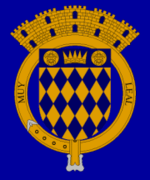 Coat of arms | |
| Nicknames: "La Villa del Capitán Correa", "Muy Leal", "Ciudad del Cetí", "Diamante del Norte" (Diamond of the North) | |
| Anthem: "Arecibo" | |
 Location of Arecibo within Puerto Rico | |
| Coordinates: 18°22′30″N 66°37′30″W | |
| Commonwealth | |
| Founded | 1616 (town/pueblo) |
| Government | |
| • Mayor | Carlos Molina (PNP) |
| • Senatorial dist. | 3 – Arecibo |
| • Representative dist. | 13, 14 |
| Area | |
| • Total | 171.22 sq mi (443.5 km2) |
| • Land | 125.99 sq mi (326.3 km2) |
| • Water | 45.23 sq mi (117.1 km2) |
| Elevation | 23 ft (7 m) |
| Population (2010)[1] | |
| • Total | 96,440 |
| • Density | 794.8/sq mi (306.9/km2) |
| • Racial groups (2010 Census)[2] | 85.5% White 5.1% Black 0.5% American Indian 0.2% Asian 8.6% mixed or other |
| Demonym(s) | Arecibeños |
| Time zone | UTC−4 (AST) |
| Zip code | 00612, 00613, 00614, 00616, 00652, 00688 |
| Area code(s) | 787 |
| Major routes | |
The Arecibo Observatory, which until July 2016 was the world's largest radio telescope, is located here. Arecibo is the seat of the Roman Catholic Diocese of Arecibo.
History
When the Spanish arrived, they found the area occupied by the indigenous Taíno, led by Xamaica Arasibo, Cacique (chief) of the yucayeque (town) then named Abacoa.[3][4]
Spanish colonists settled Arecibo in 1556, which they named for the cacique. It was their fourth settlement on the island, after Caparra (which later became San Juan), San German, and Coamo.[5] Arecibo was officially founded as a town[6] by the Spanish crown on May 1, 1616, under the governorship of Captain Felipe de Beaumont y Navarra, when the King of Spain granted the land (and the Taino living there) to Lope Conchillos. This gave the city its nickname The Village of Captain Correo (La Villa del Capitan Correa).[3]
For some time the island was competed for by other European powers. On August 5, 1702, Captain Antonio de los Reyes Correa, a member of the Spanish Army, successfully defended Arecibo from a British Navy invasion led by rear-admiral William Whetstone. Commanding two British Navy ships and 40 men, Whetstone tried to take control of the city. Correa ambushed his forces, killing 22 British seamen and driving them off. The Spanish defenders suffered only one death and three wounded soldiers.
In 1778, Arecibo, by royal decree, was awarded the "Villa" status, though it was not integrated as such until 1802. In 1850 it was awarded the "Muy Leal" (very loyal). Over time, large part of its territory became separate municipalities. These include Manati, Barceloneta, Florida, Utuado, Jayuya, Hatillo, Camuy, Quebradillas and Isabela. In 1982, it was promoted to city status, though it continued to be known by its previous nickname.
Geography
Arecibo is located in the Northern Coastal Plain region of Puerto Rico, extending inland into the Karst region. It lies south of the Atlantic Ocean; north of Utuado; east of Hatillo; and west of Barceloneta and Florida. The city occupies an area of 127 square miles (330 km2), of which, 45.23 sq mi (117.1 km2), is water.[7][8]
The Rio Grande de Arecibo is the main river in the municipality, running through the middle of it. South of the municipality, in the karst region, it forms the Dos Bocas Lake, a primary source of water for Northern Puerto Rico. Several rivers feed the Rio Grande, including the Tanama River. Caño Santiago is an artificial canal created in the 19th century by partially diverting the Tanama River's waters towards a small temporary stream, to supply water to poor neighborhoods in Arecibo, discharging into the Arecibo River near its own mouth. In the 1950s it was modified to pass slightly more south of the city center. Poor maintenance, sediment and pollution has turned the canal once again into a temporary stream. East of the river lies Caño Tiburones, an important marshland area that provides habitat for many kinds of birds and wildlife.
Arecibo has two forest reserves. Cambalache State Forest is located along the Barceloneta city limits, while Rio Abajo State Forest is located between Arecibo and Utuado. Caves include Cueva Ventana, which overlooks a valley formed by the Rio Grande de Arecibo, and La Cueva del Indio (Cave of the Indian), where paintings made by prehistoric indigenous peoples have been seen.
Environmental impact studies have been done to consider remedies for flooding that often occurs in Arecibo.[9]
Barrios
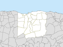
Like all municipalities of Puerto Rico, Arecibo is subdivided into barrios. The municipal buildings, central square and large Catholic church are located in a small barrio referred to as "el pueblo", near the center of the municipality.[10][11]
Sectors
Barrios (which are like minor civil divisions)[12] in turn are further subdivided into smaller local populated place areas/units called sectores (sectors in English). The types of sectores may vary, from normally sector to urbanización to reparto to barriada to residencial, among others.[13][14][15]
Special Communities
Of the 742 places on the list of Comunidades Especiales de Puerto Rico, the following barrios, communities, sectors, or neighborhoods are in Arecibo:
- Animas – Factor 1
- Sector Los Muertos in Arrozal
- Sector El Jobo in Rio Arriba
- Sector El Valle in Rio Arriba
- Buenos Aires (Magallanes)
- Calichoza
- Canta Gallo
- Carreras
- Cruz Roja
- El Cerro – Factor 1
- Abra San Francisco
- El Vigía
- Esperanza (Cienagueta)
- La Planta
- Palo Blanco
- Sector Carolina in Sabana Hoyos.[16]
Climate
Tropical monsoon climate, occasionally also known as a tropical wet climate or tropical monsoon and trade-wind littoral climate in climate classification, is a relatively rare type of climate. The Köppen Climate Classification subtype for this climate is "Am". (Tropical Monsoon Climate).[17]
| Climate data for Arecibo, Puerto Rico | |||||||||||||
|---|---|---|---|---|---|---|---|---|---|---|---|---|---|
| Month | Jan | Feb | Mar | Apr | May | Jun | Jul | Aug | Sep | Oct | Nov | Dec | Year |
| Average high °F (°C) | 84 (29) |
84 (29) |
86 (30) |
87 (31) |
88 (31) |
90 (32) |
90 (32) |
90 (32) |
90 (32) |
90 (32) |
88 (31) |
88 (31) |
88 (31) |
| Average low °F (°C) | 65 (18) |
64 (18) |
65 (18) |
66 (19) |
69 (21) |
70 (21) |
71 (22) |
71 (22) |
70 (21) |
70 (21) |
68 (20) |
66 (19) |
68 (20) |
| Average precipitation inches (mm) | 4.6 (120) |
3.1 (79) |
2.8 (71) |
3.8 (97) |
5.8 (150) |
4.0 (100) |
3.8 (97) |
4.5 (110) |
5.1 (130) |
5.2 (130) |
6.1 (150) |
5.8 (150) |
54.5 (1,380) |
| Source: Weatherbase[18] | |||||||||||||
Tourism
Landmarks and places of interest
- Arecibo Harbor
The Arecibo Harbor is managed by the Puerto Rico Ports Authority.[19]
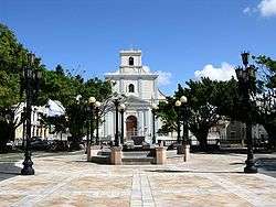
Arecibo is one of the oldest colonial towns in Puerto Rico (1616). Among its historic buildings is the Cathedral of Saint Phillip Apostle, built beginning in the late 18th century. The first church, built in the middle of the 17th century, was destroyed by an earthquake in 1787. Construction of its replacement began soon after, although it was not completed until 1846. Four days after its dedication, an earthquake seriously damaged it. Repairs were not completed until 1882. The 1918 earthquake damaged the vault so badly that it was replaced by a flat concrete roof; a vaulted ceiling of composition board was placed inside.
The cathedral of Arecibo is Puerto Rico's second-largest church after the Cathedral of San Juan. The plan is rectangular with three naves; the side naves are cut short to allow large flanking chapels, which occupy almost half the length of the church. The apse is semicircular, and has an unusual half-dome covering it. The facade is a triangular composition of three stages. The top stage, a short central tower, is a later addition, according to local architects and historians. Neoclassic ornamentation is used in an academic fashion on the lowest stage, but the other two show a less traditional use of bands and pilasters. The Renaissance-style windows are uncommon in Puerto Rican churches, but the central tower over the entrance is a common motif used throughout the island.
- City Hall

The City Hall, built in 1866, served as jail to revolutionaries of El Grito de Lares in 1868. In the 1918 earthquake, the frontal section of the building was destroyed. When repairs were made, a tower and clock were added to the building. In 1978, the building was restored to its original form.
The City Hall of Arecibo is typical of these regional seats of government. It is relatively modest in size, of stuccoed masonry, with an academically correct composition, having a pedimented center pavilion which projects slightly. The lower story is rusticated, with arched openings; the three doorways in the center giving the effect of a loggia. The upper windows all have segmental pediments and balconies; the central trio share one long balcony. Architectural detailing is modest, but the building is graceful and charming.
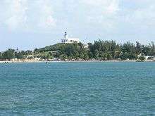
In 1898 the Spaniards built the Arecibo Lighthouse. It was automated in 1964 and is still in use. A small park, Arecibo Lighthouse and Historical Park, has been established around it.
The Arecibo Observatory is the largest single-unit radio telescope ever constructed and one of the world's most powerful radar-radio telescopes. The observatory's purpose is to support scientific studies. It has attracted several Hollywood directors who have filmed there; most recently GoldenEye and Contact. The radio telescope was used in 1974 to send the Arecibo message to space.
- Cambalache Forest Reserve

Forest between Arecibo and Barceloneta.
- Casa Ulanga
Originally a residence built by Spanish immigrant Francisco Ulanga, it has served multiple uses. It was later used as a bank, store, city hall of Arecibo, hospital, jail, tribunal, and is now operated as the Arecibo Cultural Center.
- Cueva del Indio

Archeological site where Taíno drawings can be found.
- Christopher Columbus statue
The "Birth of the New World" statue depicts Christopher Columbus is located in Arecibo.[20][21] 295 ft (90 m). The statue is the work of Russian sculptor Zurab Tsereteli, and it is the tallest statue in the Americas.[22]
- Dos Bocas Lake
Reservoir located between the municipalities of Arecibo and Utuado.
- Paseo Victor Rojas (Victor Rojas Walk)
Also known as Paseo de Damas or simply El Fuerte, it was built in 1881 where Fort San Miguel's ruins once were.
- Manuel "Petaca" Iguina Coliseum
Home of the Arecibo Captains basketball team.
- Beaches
Nearby beaches include Los Morillos, Los Negritos, Poza del Obispo, and Las Tunas.
- Museum of Art and History of Arecibo
Shows art from local artists and shows the city's history.
Also nearby (18°29′N 66°26′W) is a facility for launching sounding rockets. Since 1966 many rockets of the Nike Apache, Nike Javellin, Nike Iroquois, Nike Tomahawk, Black Brant, Taurus Orion, and Terrier Orion types have been launched from this facility.
Culture
Festivals and events
- Bicycle Competitions – January
- Arecibo Carnival – February
- Festival de paracaidismo de Puerto Rico[23] (Freefall festival of Puerto Rico) – February
- Patron Festivities San Felipe Apóstol – May
- Playero Festival – July
- Folklore Festival – July
- Craftsman Fair – September
- Ceti Festival – November
- Puerto Rico's Flag Centennial – December
- Yesenia Montero's Horse festival – December
Sports
Arecibo has two professional sports franchises, the Lobos de Arecibo in baseball and the Capitanes de Arecibo in BSN basketball. The Lobos won the 1983 national baseball championship and the 1983 Caribbean World Series, the only time the franchise won both titles. At that time, they had MLB prospect Dickie Thon, then also of the Houston Astros, on their roster. Thon then suffered a life-threatening and career-affecting eye injury during an Astros game in 1984. The Lobos won a championship again in 1996.
The Capitanes won their first ever championship in 1959. After that, the Capitanes have not had much luck in their basketball tournaments, but in 2002, they started to turn things around, reaching the semifinals. However, they lost the series to the Vaqueros by losing four straight games, after having a 3–0 game lead in the series. The Capitanes won the National Superior Basketball championship in 2005 beating the Vaqueros of Bayamón in four games. This was the first championship in 46 years. In 2007 they got to the finals, losing in the overtime on the seventh game of the series against Los Cangrejos de Santurce. In 2008 Arecibo won the tournament championship again, against the Gigantes of Carolina. In 2010, they won again against Los Vaqueros of Bayamon.
Economy
.jpg)
Arecibo's economy is diverse with pharmaceuticals, agriculture and fishing.[8] Vaqueria Ceiba Del Mar is located in Arecibo and is one of the largest on the island of Puerto Rico. They also have operations in Hatillo. After Hurricane Maria, the farm had to consolidate their three operations into one.
Business
Arecibo's main shopping mall is Plaza del Atlantico as well as the one situated in the neighboring town of Hatillo, Plaza del Norte.
Industrial
Arecibo is home to Fortune 500 corporations such as Merck, General Electric. Other important companies are Thermo King Corporation, Eaton, Los Cidrines, Expressway Eco Printing, Arecibo Tropical Flag and ABB.
Demographics
The municipality of Arecibo is 60.24% white (of European descent), 26.23% mixed (multi-racial, including European, African and Native American, as individuals self-identify), 9.7% black (African-Puerto Rican descent), and 3.8% Asian (south Asian or east Asian). The majority of the population is mostly of Spanish descent, but there has been intermarriage with more recent groups from other parts of Europe. with some having Middle Eastern, French, Italian, American or of other descent. People who are multi-racial may also have ancestors more than one of the European groups, and among more than one African nation as well. Ethnic Asians are mostly from India and China.
The United States took control of Puerto Rico from Spain in the aftermath of the Spanish-American War under the terms of the Treaty of Paris of 1898 and conducted its first census of Puerto Rico, finding that the population of Arecibo was 36,910.
| Historical population | |||
|---|---|---|---|
| Census | Pop. | %± | |
| 1900 | 36,910 | — | |
| 1910 | 42,429 | 15.0% | |
| 1920 | 46,578 | 9.8% | |
| 1930 | 56,525 | 21.4% | |
| 1940 | 69,192 | 22.4% | |
| 1950 | 75,361 | 8.9% | |
| 1960 | 69,879 | −7.3% | |
| 1970 | 73,468 | 5.1% | |
| 1980 | 86,766 | 18.1% | |
| 1990 | 93,385 | 7.6% | |
| 2000 | 100,131 | 7.2% | |
| 2010 | 96,440 | −3.7% | |
| U.S. Decennial Census[25] 1899 (shown as 1900)[26] 1910–1930[27] 1930-1950[28] 1960–2000[29] 2010[30] | |||
Government
All municipalities in Puerto Rico are administered by a mayor, elected every four years. The current mayor of Arecibo is Carlos Molina, of the New Progressive Party (PNP). He was elected at the 2012 general elections.
The city belongs to the Puerto Rico Senatorial district III, which is represented by two Senators. In 2008, José Emilio González and Angel Martínez were elected as District Senators.[31]
Symbols
Flag
The flag of Arecibo derives its composition and colors from the coat of arms of the city. It is divided vertically in two equal parts. The left side is blue having a belt that stands for "Captain Correa", a local military hero from Spanish times. The right side is made up of blue and yellow diamonds alternating in a checkerboard pattern referring to the coat of arms of Felipe de Beaumont y Navarra governor of Puerto Rico (1614–1620) and founder of the city. The crown represents The Cacique (chieftain) Arasibo (Fransico Jamaica Arasibo). The turtles represent the ancientness of the city (the third city of Puerto Rico) also because of the indigenous people of the region and that the hunting of turtles was a source of wealth. The towers were a form to describe the population of a settlement. Three towers represent a municipality, four towers represent a village, and five towers represent a city.[3]
Coat of arms
The shield is divided by diagonal lines in golden and blue rhombuses with a blue stripe in the superior part, in which resides an opened five-point crown and which is adorned with drawings characterizing the art of the Taínos. The people of Arecibo also honored Captain Antonio de los Reyes Correa by including a gold colored belt in their coat of arms with the words "Muy Leal", which means "Very Faithful", in representation of Correa.[32] This combination of symbols represents the Indian Cacique (Chieftain) from whom the population's name derives, the governor that erected the town and the hero Captain Correa who defended the town from a British invasion.[3]
Nicknames
Arecibo is known as "La Villa del Capitán Correa" (Captain Correa's Villa) after the Puerto Rican hero Captain Antonio de los Reyes Correa of the Spanish Army, who drove off a British Navy invasion by ambushing forces led by rear-admiral William Whetstone. Arecibo is also known as "El Diamante Del Norte" (The Diamond of the North).
Transportation
Arecibo has a small noncommercial airport, named Antonio (Nery) Juarbe Pol Airport, which currently has no commercial airline flights.
PR-22 (unsigned Interstate PR-2) passes through the city, but bypasses downtown. Downtown can be accessed via PR-2, PR-10 and PR-129.
There are 51 bridges in Arecibo.[33]
Education
Arecibo is home to several public and private schools distributed through several regions. Public education is handled by the State Department of Education.
There are also several colleges and universities located in the city. Some of them are:
- University of Puerto Rico at Arecibo
- Interamerican University of Puerto Rico
- Pontifical Catholic University of Puerto Rico
- Universidad del Este
It also has several other technical institutions like the National College of Business and Technology and the ICPR Junior College.
Notable people
The following is a list of notable people from Arecibo:
- Antonio de los Reyes Correa – military hero
- Arasibo – Taino Cacique
- Cayetano Coll y Cuchí – the first President of Puerto Rico House of Representatives
- Cayetano Coll y Toste – historian
- Delma S. Arrigoitia – author
- Edna Coll – educator
- Francisco Gonzalo Marín – poet who fought for Cuba's independence
- Isabel Cuchí Coll – journalist
- José Coll y Cuchí – politician; founder of Puerto Rican Nationalist Party
- Luisa Capetillo – union leader/civil rights activist
- Manuel Zeno Gandía – author
- María Cadilla – educator
- Melba Acosta – Secretary of Treasury of PR
- Myrta Silva – singer
- René Marqués – playwright
Due to space limitations it is almost impossible to list all of the people of Arecibo who have distinguished themselves, and therefore a category has been created to this effect:
See also
References
- "American FactFinder". Factfinder.census.gov. Archived from the original on 2020-02-12. Retrieved 2013-11-01.
- "Demographics/Ethnic U.S. 2000 census" (PDF). Archived (PDF) from the original on 2008-02-16. Retrieved 2011-04-20.
- "Arecibo Municipality Founding History and Symbols". enciclopediapr.org. Fundación Puertorriqueña de las Humanidades (FPH). Archived from the original on 14 February 2019. Retrieved 14 February 2019.
- "Dictionary of the Taino Language". taino-tribe.org (in Spanish). Archived from the original on 13 October 2007. Retrieved 6 June 2020.
- Salvador Perea. Historia de Puerto Rico: 1537-1700. Instituto de Cultura Puertorriqueña and Universidad Católica de Puerto Rico. 1972. p. 96. ("Coamo...que fue así la tercera población oficial de vida perpetua en la isla.")
- "Arecibo: Founding and History. Archived 2019-02-14 at the Wayback Machine Accessed 11 September 2019.
- "Arecibo, Puerto Rico". Topuertorico.org. 1947-03-31. Archived from the original on 2013-11-02. Retrieved 2013-11-01.
- "Arecibo Municipality General Info (Location, Square Miles, Economy and Geography)". enciclopediapr.org. Fundación Puertorriqueña de las Humanidades (FPH). Archived from the original on 14 February 2019. Retrieved 14 February 2019.
- Rio Grande de Arecibo, Puerto Rico: Environmental Impact Statement. 1991. pp. 40–.
- Gwillim Law (20 May 2015). Administrative Subdivisions of Countries: A Comprehensive World Reference, 1900 through 1998. McFarland. p. 300. ISBN 978-1-4766-0447-3. Retrieved 25 December 2018.
- "Map of Arecibo at the Wayback Machine" (PDF). Archived from the original (PDF) on 2018-03-24. Retrieved 2018-12-29.
- "US Census Barrio-Pueblo definition". factfinder.com. US Census. Archived from the original on 13 May 2017. Retrieved 5 January 2019.
- "Agencia: Oficina del Coordinador General para el Financiamiento Socioeconómico y la Autogestión (Proposed 2016 Budget)". Puerto Rico Budgets (in Spanish). Retrieved 28 June 2019.
- Rivera Quintero, Marcia (2014), El vuelo de la esperanza: Proyecto de las Comunidades Especiales Puerto Rico, 1997-2004 (first ed.), San Juan, Puerto Rico Fundación Sila M. Calderón, ISBN 978-0-9820806-1-0
- "Leyes del 2001". Lex Juris Puerto Rico (in Spanish). Retrieved 24 June 2020.
- Rivera Quintero, Marcia (2014), El vuelo de la esperanza:Proyecto de las Comunidades Especiales Puerto Rico, 1997–2004 (Primera edición ed.), San Juan, Puerto Rico Fundación Sila M. Calderón, p. 273, ISBN 978-0-9820806-1-0
- "Climate Summary". Archived from the original on 2014-08-12. Retrieved 2013-05-24.
- "Weatherbase.com". Weatherbase. 2013. Archived from the original on 2013-06-15. Retrieved 2013-05-24. Retrieved on May 8, 2013.
- "Arecibo Harbor PR" (PDF). SAJ. US Army Corps of Engineers. Archived (PDF) from the original on 2016-12-27. Retrieved 2019-02-26.
- (in Spanish) Archived 2016-05-24 at the Wayback Machine
- Sandra Caquías Cruz (2012-03-30). "La estatua de Colón llegará a Arecibo". El Nuevo Día (in Spanish). Archived from the original on 2013-11-13. Retrieved 2012-06-08.
- "La Estatua de Colón". Atlas Obscura. Retrieved 15 June 2019.
- http://www.elnuevodia.com/fotogaleria-festivaldeparacaidismoenarecibo-1450412.html/1%5B%5D
- "Official web page of WMIA (AM)". Archived from the original on 2018-05-04. Retrieved 2018-12-28.
- "U.S. Decennial Census". United States Census Bureau. Archived from the original on February 13, 2020. Retrieved September 21, 2017.
- "Report of the Census of Porto Rico 1899". War Department, Office Director Census of Porto Rico. Archived from the original on July 16, 2017. Retrieved September 21, 2017.
- "Table 3-Population of Municipalities: 1930, 1920, and 1910" (PDF). United States Census Bureau. Archived (PDF) from the original on August 17, 2017. Retrieved September 21, 2017.
- "Table 4-Area and Population of Municipalities, Urban and Rural: 1930 to 1950" (PDF). United States Census Bureau. Archived (PDF) from the original on August 30, 2015. Retrieved September 21, 2014.
- "Table 2 Population and Housing Units: 1960 to 2000" (PDF). United States Census Bureau. Archived (PDF) from the original on July 24, 2017. Retrieved September 21, 2017.
- Puerto Rico:2010:population and housing unit counts.pdf (PDF). U.S. Dept. of Commerce, Economics and Statistics Administration, U.S. Census Bureau. 2010. Archived (PDF) from the original on 2017-02-20. Retrieved 2019-06-10.
- Elecciones Generales 2008: Escrutinio General Archived 2011-11-20 at the Wayback Machine on CEEPUR
- "Arecibo". Archived from the original on 2010-04-12. Retrieved 2009-11-23.
- "Arecibo Bridges". National Bridge Inventory Data. US Dept. of Transportation. Archived from the original on 20 February 2019. Retrieved 19 February 2019.
External links
| Wikivoyage has a travel guide for Arecibo. |
| Wikimedia Commons has media related to Arecibo, Puerto Rico. |