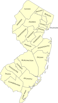
List of counties in New Jersey
There are 21 counties in New Jersey. These counties together contain 565 municipalities, or administrative entities composed of clearly defined territory; 250 boroughs, 52 cities, 15 towns, 244 townships, and 4 villages.[1] In New Jersey, a county is a local level of government between the state and municipalities. County government in New Jersey includes a Board of Chosen Freeholders,[2] sheriff, clerk, and surrogate (responsible for uncontested and routine probate),[3] all of which are elected officials. Counties organized under the Optional County Charter Law may also have an elected county executive.[4] Counties traditionally perform state-mandated duties such as the maintenance of jails, parks, and certain roads.[5] The site of a county's administration and courts is called the county seat.
| Counties of New Jersey | |
|---|---|
  | |
| Location | State of New Jersey |
| Number | 21 |
| Populations | 62,607 (Salem) – 936,692 (Bergen) |
| Areas | 47 square miles (120 km2) (Hudson) – 805 square miles (2,080 km2) (Burlington) |
| Government | County government |
| Subdivisions | borough, city, town, township, village |
History
New Jersey was governed by two groups of proprietors as two distinct provinces, East Jersey and West Jersey, between 1674 and 1702. New Jersey's first counties were created as administrative districts within each province, with East Jersey split in 1675 into Bergen, Essex, Middlesex and Monmouth counties, while West Jersey's initial counties of Burlington and Salem date to 1681.[6][7] The most recent county created in New Jersey is Union County, created in 1857 and named after the union of the United States when the Civil War was imminent. New Jersey's county names derive from several sources, though most of its counties are named after place names in England and prominent leaders in the colonial and revolutionary periods. Bergen County is the most populous county—as of the 2010 Census—with 905,116 people, while Salem County is the least populous with 66,083 people.
Representation in the New Jersey Legislature
Until the 1960s, the New Jersey Senate had 21 representatives, one from each county regardless of population. In the wake of the 1964 decision by the Supreme Court of the United States in Reynolds v. Sims, establishing the one man, one vote principle that state legislative districts must be approximately equal in size, David Friedland filed suit in New Jersey Supreme Court on behalf of two union leaders, challenging a system under which each county was represented by a single member in the New Jersey Senate. The senate enacted a proposal whereby each senator's vote would be weighted based on the population of the county represented, under which Cape May County's senator would receive one vote while the senator from Essex County would receive 19.1, in direct relation to the ratio of residents between counties.[8] In a decision issued on December 15, 1964, the Supreme Court ruled unanimously that the weighted voting system as adopted was unconstitutional. The court ordered that interim measures be established for the 1965 legislative elections, in which weighted voting could be used as a temporary measure, and that the needed constitutional changes to restructure the New Jersey Legislature to be in compliance with "one man, one vote" requirements be in place before elections took place in 1967.[8] The legislature's final decision was to establish 40 districts statewide, each represented by one senator and two assemblymembers, without relation to county boundaries.
FIPS code
The Federal Information Processing Standard (FIPS) code, used by the United States government to uniquely identify counties, is provided with each entry. FIPS codes are five-digit numbers; for New Jersey the codes start with 34 and are completed with the three-digit county code. The FIPS code for each county in the table links to census data for that county.[9]
Counties
| County |
FIPS code[9] | County seat[10] | Largest City[11] | Est.[10] | Formed from[6][7] | Named for[12] | Density (per mi²) | Pop.[13] | Area[10] | Map |
|---|---|---|---|---|---|---|---|---|---|---|
| Atlantic County | 001 | Mays Landing | Galloway Township 37,349 | 1837 | Gloucester County | The Atlantic Ocean, which forms the county's eastern border | 489.39 | 265,429 | 561 sq mi (1,453 km2) | 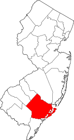 |
| Bergen County | 003 | Hackensack | Hackensack 43,010 | 1683 | One of 4 original counties created in East Jersey | Bergen, New Netherland settlement | 3,868.02 | 936,692 | 234 sq mi (606 km2) | 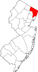 |
| Burlington County | 005 | Mount Holly | Evesham Township 45,538 | 1694 | One of two original counties created in West Jersey | The old ancient name for an inland market near Bridlington, England | 557.43 | 445,384 | 805 sq mi (2,085 km2) | 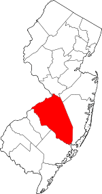 |
| Camden County | 007 | Camden | Camden 77,344 | 1844 | Gloucester County | Charles Pratt, 1st Earl Camden (1714–1794), an English supporter of the colonists during the American Revolution[14] | 2,313.77 | 507,078 | 222 sq mi (575 km2) | 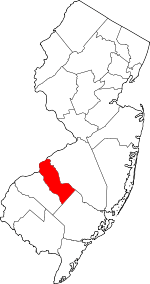 |
| Cape May County | 009 | Cape May Court House | Lower Township 22,844 | 1692 | Burlington County | The 17th-century Dutch explorer Cornelius Jacobsen Mey, who explored and surveyed the Delaware Bay to the south of the county | 381.43 | 92,560 | 255 sq mi (660 km2) | 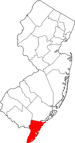 |
| Cumberland County | 011 | Bridgeton | Vineland 60,724 | 1748 | Salem County | Prince William, Duke of Cumberland (1721–1765), second son of George II of England and military victor at the Battle of Culloden in 1746 | 320.85 | 150,972 | 489 sq mi (1,267 km2) | 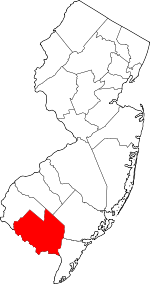 |
| Essex County | 013 | Newark | Newark 277,140 | 1683 | One of four original counties created in East Jersey | The county of Essex in England | 6,221.98 | 799,767 | 126 sq mi (326 km2) | 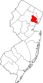 |
| Gloucester County | 015 | Woodbury | Washington Township 48,559 | 1686 | Burlington County | The city of Gloucester, England | 887.04 | 291,408 | 325 sq mi (842 km2) | 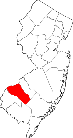 |
| Hudson County | 017 | Jersey City | Jersey City 247,597 | 1840 | Bergen County | The English explorer Henry Hudson (d. 1611), who explored portions of New Jersey's coastline | 13,495.02 | 676,061 | 47 sq mi (122 km2) | 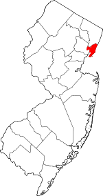 |
| Hunterdon County | 019 | Flemington | Raritan Township 21,936 | 1714 | Burlington County | Robert Hunter (1664–1734), the Colonial Governor of New Jersey from 1710 to 1720 | 298.49 | 124,714 | 430 sq mi (1,114 km2) | 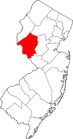 |
| Mercer County | 021 | Trenton | Hamilton Township 88,464 | 1838 | Burlington County, Hunterdon County, Middlesex County, and Somerset County | The Continental Army General Hugh Mercer (1726–1777), who died at the Battle of Princeton[15] | 1,621.74 | 369,811 | 226 sq mi (585 km2) | 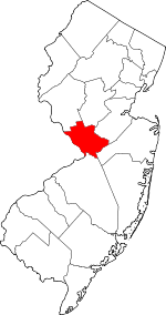 |
| Middlesex County | 023 | New Brunswick | Edison 99,967 | 1683 | One of four original counties created in East Jersey | The historic county of Middlesex in England | 2,604.05 | 829,685 | 311 sq mi (805 km2) | 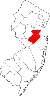 |
| Monmouth County | 025 | Freehold Borough | Middletown Township 66,522 | 1683 | One of four original counties created in East Jersey | The historic county of Monmouthshire in Wales | 1,335.55 | 621,354 | 472 sq mi (1,222 km2) |  |
| Morris County | 027 | Morristown | Parsippany-Troy Hills 53,238 | 1739 | Hunterdon County | Colonel Lewis Morris (1671–1746), colonial governor of New Jersey at the time of the county's formation[16][17] | 1,049.63 | 494,228 | 469 sq mi (1,215 km2) | 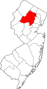 |
| Ocean County | 029 | Toms River | Lakewood Township 92,843 | 1850 | Monmouth County and Burlington County | The Atlantic Ocean, which forms the eastern border of New Jersey | 629.44 | 601,651 | 636 sq mi (1,647 km2) | 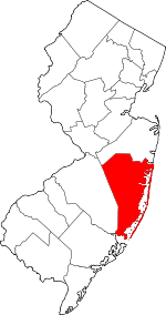 |
| Passaic County | 031 | Paterson | Paterson 146,199 | 1837 | Bergen County and Essex County | "Pasaeck", a Lenape word meaning "valley" | 2,709.33 | 503,310 | 185 sq mi (479 km2) |  |
| Salem County | 033 | Salem | Pennsville Township 13,332 | 1694 | One of two original counties created in West Jersey | A Hebrew word meaning "peace" | 195.51 | 62,607 | 338 sq mi (875 km2) | 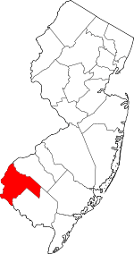 |
| Somerset County | 035 | Somerville | Franklin Township 62,300 | 1688 | Middlesex County | The county of Somerset in England | 1,060.47 | 331,164 | 305 sq mi (790 km2) | 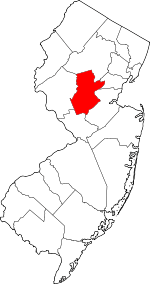 |
| Sussex County | 037 | Newton | Vernon Township 23,867 | 1753 | Morris County | The county of Sussex in England | 286.5 | 140,799 | 521 sq mi (1,349 km2) | 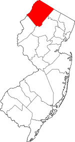 |
| Union County | 039 | Elizabeth | Elizabeth 124,969 | 1857 | Essex County | The union of the United States, which was being threatened by the dispute over slavery | 5,208.73 | 558,067 | 103 sq mi (267 km2) | 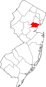 |
| Warren County | 041 | Belvidere | Phillipsburg 14,791 | 1824 | Sussex County | The American Revolutionary War General Joseph Warren (1741–1775), killed at the Battle of Bunker Hill | 303.61 | 105,779 | 358 sq mi (927 km2) | 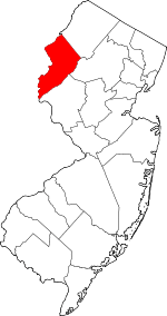 |
See also
- List of townships in New Jersey
- County courthouses in New Jersey
- List of United States counties and county equivalents
- Metropolitan Statistical Areas of New Jersey—each New Jersey county is included in a Metropolitan Statistical Area as defined by the federal Office of Management and Budget
References
- "New Jersey – Place and County Subdivision". U.S. Census Bureau. Archived from the original on November 22, 2009. Retrieved September 6, 2009.
- Coppa, Frank J. (2000). County government: a guide to efficient and accountable government. Greenwood Publishing Group. pp. 39–40. ISBN 978-0-275-96829-8. Retrieved August 31, 2009.
- Coppa, County government, p. 165
- Coppa, County government, p. 108
- "An Overview of County Government". National Association of Counties. Archived from the original on April 17, 2013. Retrieved February 1, 2011.
- "County Formation Map" (PDF). New Jersey Association of Election Officials. Archived from the original (PDF) on 2007-07-24. Retrieved August 30, 2009.
- Torp, Kim (2006). "New Jersey County Formation". Genealogy Trails. Retrieved August 30, 2009.
- Wright, George Cable (December 16, 1964). "Weighted Voting Voided in Jersey; State's Highest Court Bars Senate's Plan – No Ruling on Its Constitutionality New Jersey Supreme Court Bars Senate's Weighted Vote Plan". The New York Times. The New York Times Company. Retrieved September 1, 2009.
- "County FIPS Code Listing for the State of New Jersey". US Environmental Protection Agency. Archived from the original on July 1, 2016. Retrieved May 27, 2016.
- "NACo – Find a county". National Association of Counties. Archived from the original on January 12, 2008. Retrieved January 25, 2008.
- List of municipalities in New Jersey
- Hutchinson, Viola L. The Origin of New Jersey Place Names, New Jersey Public Library Commission, May 1945. Accessed November 14, 2015.
- https://www.census.gov/quickfacts/fact/table/NJ/PST045218
- Greenberg, Gail (August 30, 2009). "A Brief History of Camden County". Camden County Board of Freeholders. Archived from the original on June 23, 2009. Retrieved August 31, 2009.
- "History". Mercer County Cultural & Heritage Commission. Archived from the original on February 21, 2009. Retrieved August 31, 2009.
- "The Land Past and Present". Morris County Board of Chosen Freeholders. Archived from the original on August 22, 2009. Retrieved August 30, 2009.
- "How did our county get its name?". Morris County Library. July 26, 2008. Archived from the original on February 23, 2009. Retrieved August 31, 2009.
