Washington County, Rhode Island
Washington County, known locally as South County, is a county located in the U.S. state of Rhode Island. As of the 2010 census, the population was 126,979.[1] Rhode Island counties have no governmental functions other than as court administrative and sheriff corrections boundaries, which are part of the state government.[2]
Washington County | |
|---|---|
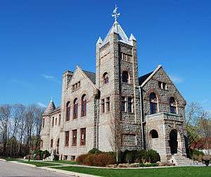 Former Washington County Courthouse in West Kingston | |
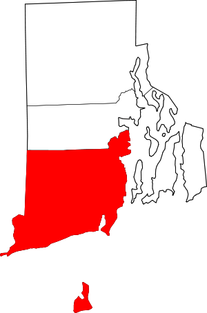 Location within the U.S. state of Rhode Island | |
 Rhode Island's location within the U.S. | |
| Coordinates: 41°27′16″N 71°34′52″W | |
| Country | |
| State | |
| Founded | June 3, 1729 |
| Seat | South Kingstown |
| Largest town | South Kingstown |
| Area | |
| • Total | 563 sq mi (1,460 km2) |
| • Land | 329 sq mi (850 km2) |
| • Water | 234 sq mi (610 km2) 41%% |
| Population (2010) | |
| • Total | 126,979 |
| • Estimate (2019) | 125,577 |
| • Density | 230/sq mi (87/km2) |
| Time zone | UTC−5 (Eastern) |
| • Summer (DST) | UTC−4 (EDT) |
| Congressional district | 2nd |
History
Washington County was created as Kings County in 1729 within the Colony of Rhode Island and Providence Plantations. It was renamed Washington County on October 29, 1781 in honor of George Washington. At the earliest stage of colonial settlement, the area was called "The Narragansett Country", named after the Naragansett tribe and its tributary tribe the Niantics, both of whom lived in the area.
Early land purchases in the Narragansett Country were effected by settlers after the establishment of Indian trading posts at Fort Neck in Charlestown, and at "Smith's Castle" in Wickford. A series of conflicts involving the Manisseans on Block Island gave that island to the Massachusetts Bay Colony for a number of years, before being transferred to the Rhode Island Colony under Newport County, and then finally to Washington County in 1959.
The borders of the Narragansett country were disputed for nearly 100 years among the colonies of Rhode Island, Connecticut, and Massachusetts. The Narragansetts had pledged their fealty to King Charles, and the area was known as "The King's Province" and was placed under the authority of Rhode Island "until the King's pleasure was further known". In 1664, a royal commission under Charles II stepped in to adjudicate these conflicting claims. The commission extinguished the claims of Massachusetts, and Rhode Island was granted jurisdiction until the commission finished processing Connecticut's appeals, which were not ended until 1726. Settlements of King's Province were named to reflect the English Restoration, in honor of King Charles II. Towns reflecting this history include the two Kingstowns and Charlestown, as well as the villages of Kingston and West Kingston.
Washington County is also known in Rhode Island as "South County".[3]
Geography
According to the U.S. Census Bureau, the county has a total area of 563 square miles (1,460 km2), of which 329 square miles (850 km2) is land and 234 square miles (610 km2) (41%) is water.[4] It is the largest county in Rhode Island by total area. The county's topography ranges from flat along the shoreline to gently rolling hills farther inland. The highest point is a large area approximately 560 feet (171 m) above sea level in the Exeter neighborhood of Black Plain;[5] the lowest point is sea level along the coast. The northern boundary west of Davisville is approximately 41.60°N. The western boundary north of Westerly is approximately −71.79°W.
National protected areas
- Block Island National Wildlife Refuge
- John H. Chafee National Wildlife Refuge
- Ninigret National Wildlife Refuge
- Trustom Pond National Wildlife Refuge
Demographics
| Historical population | |||
|---|---|---|---|
| Census | Pop. | %± | |
| 1790 | 18,323 | — | |
| 1800 | 16,135 | −11.9% | |
| 1810 | 14,962 | −7.3% | |
| 1820 | 15,687 | 4.8% | |
| 1830 | 15,411 | −1.8% | |
| 1840 | 14,324 | −7.1% | |
| 1850 | 16,430 | 14.7% | |
| 1860 | 18,715 | 13.9% | |
| 1870 | 20,097 | 7.4% | |
| 1880 | 22,495 | 11.9% | |
| 1890 | 23,649 | 5.1% | |
| 1900 | 24,154 | 2.1% | |
| 1910 | 24,942 | 3.3% | |
| 1920 | 24,932 | 0.0% | |
| 1930 | 29,334 | 17.7% | |
| 1940 | 32,493 | 10.8% | |
| 1950 | 48,542 | 49.4% | |
| 1960 | 59,054 | 21.7% | |
| 1970 | 83,586 | 41.5% | |
| 1980 | 93,317 | 11.6% | |
| 1990 | 110,006 | 17.9% | |
| 2000 | 123,546 | 12.3% | |
| 2010 | 126,979 | 2.8% | |
| Est. 2019 | 125,577 | [6] | −1.1% |
| U.S. Decennial Census[7] 1790-1960[8] 1900-1990[9] 1990-2000[10] 2010-2019[1] | |||
As of the 2010 United States Census, there were 126,979 people, 49,177 households, and 32,297 families residing in the county.[11] The population density was 385.7 inhabitants per square mile (148.9/km2). There were 62,206 housing units at an average density of 188.9 per square mile (72.9/km2).[12] The racial makeup of the county was 93.8% white, 1.6% Asian, 1.2% black or African American, 0.9% American Indian, 0.7% from other races, and 1.8% from two or more races. Those of Hispanic or Latino origin made up 2.4% of the population.[11]
The largest ancestry groups were:[13]
- 27.8% Irish
- 21.4% Italian
- 19.9% English
- 11.4% French
- 10.8% German
- 4.9% Portuguese
- 4.8% Polish
- 4.3% French Canadian
- 3.5% Scottish
- 2.9% Swedish
- 2.7% American
- 2.5% Scotch-Irish
- 1.4% Russian
Of the 49,177 households, 28.6% had children under the age of 18 living with them, 52.2% were married couples living together, 9.5% had a female householder with no husband present, 34.3% were non-families, and 26.1% of all households were made up of individuals. The average household size was 2.45 and the average family size was 2.95. The median age was 42.3 years.[11]
The median income for a household in the county was $70,285 and the median income for a family was $87,999. Males had a median income of $59,598 versus $44,851 for females. The per capita income for the county was $34,737. About 3.4% of families and 7.4% of the population were below the poverty line, including 6.3% of those under age 18 and 5.0% of those age 65 or over.[14]
Communities
Towns
- Charlestown
- Exeter
- Hopkinton
- Narragansett
- New Shoreham
- North Kingstown
- Richmond
- South Kingstown (traditional county seat)
- Westerly
Census-designated places
- Ashaway
- Bradford
- Carolina
- Charlestown
- Hope Valley
- Hopkinton
- Kingston
- Misquamicut
- Narragansett Pier
- Quonochontaug
- Wakefield-Peacedale
- Watch Hill
- Weekapaug
- Westerly
- Wyoming
Other villages
- Alton
- Arcadia
- Ashaway
- Barberville
- Bethel
- Burdickville
- Canonchet
- Centerville
- Davisville
- Galilee
- Hamilton
- Hopkinton City
- Jerusalem
- Kenyon
- Lafayette
- Locustville
- Matunuck
- Moscow
- Peace Dale
- Point Judith
- Rockville
- Saunderstown
- Shannock
- Shelter Harbor
- Slocum
- South Hopkinton
- Usquepaug
- Wakefield
- West Kingston
- White Rock
- Wickford
- Wood River Junction
- Woodville
Politics
| Year | Republican | Democratic | Third parties |
|---|---|---|---|
| 2016 | 41.0% 27,230 | 50.8% 33,741 | 8.1% 5,398 |
| 2012 | 40.3% 25,366 | 57.1% 35,888 | 2.6% 1,625 |
| 2008 | 38.7% 25,624 | 59.1% 39,082 | 2.2% 1,454 |
| 2004 | 42.4% 26,533 | 55.4% 34,679 | 2.3% 1,422 |
| 2000 | 37.8% 21,253 | 52.6% 29,560 | 9.6% 5,411 |
| 1996 | 32.7% 16,302 | 52.1% 25,958 | 15.2% 7,572 |
| 1992 | 30.6% 16,211 | 43.5% 23,009 | 25.9% 13,724 |
| 1988 | 48.0% 21,650 | 51.5% 23,210 | 0.5% 202 |
| 1984 | 57.6% 24,365 | 42.1% 17,793 | 0.4% 147 |
| 1980 | 41.5% 16,932 | 40.2% 16,429 | 18.3% 7,466 |
| 1976 | 49.6% 17,856 | 49.9% 17,980 | 0.5% 186 |
| 1972 | 58.5% 19,280 | 41.4% 13,637 | 0.2% 62 |
| 1968 | 43.4% 11,639 | 51.7% 13,851 | 5.0% 1,328 |
| 1964 | 29.6% 7,342 | 70.4% 17,434 | |
| 1960 | 52.2% 12,651 | 47.8% 11,580 | |
| 1956 | 65.7% 14,278 | 34.3% 7,450 | |
| 1952 | 61.3% 13,389 | 38.7% 8,448 | 0.0% 9 |
| 1948 | 55.9% 9,522 | 43.3% 7,379 | 0.8% 140 |
| 1944 | 56.1% 8,233 | 43.8% 6,419 | 0.1% 18 |
| 1940 | 60.5% 9,233 | 39.4% 6,001 | 0.1% 17 |
| 1936 | 58.2% 8,764 | 39.6% 5,956 | 2.2% 336 |
| 1932 | 58.4% 7,307 | 40.4% 5,047 | 1.2% 153 |
| 1928 | 68.8% 7,793 | 30.9% 3,500 | 0.2% 27 |
| 1924 | 75.2% 8,038 | 22.1% 2,366 | 2.6% 283 |
| 1920 | 74.9% 6,420 | 23.5% 2,012 | 1.6% 136 |
| 1916 | 55.2% 2,837 | 43.3% 2,224 | 1.6% 81 |
| 1912 | 44.9% 2,129 | 35.7% 1,691 | 19.4% 921 |
| 1908 | 66.5% 3,043 | 27.9% 1,278 | 5.6% 258 |
| 1904 | 70.6% 3,189 | 26.5% 1,197 | 2.9% 129 |
| 1900 | 66.4% 2,421 | 26.3% 960 | 7.3% 268 |
| 1896 | 72.1% 3,040 | 15.5% 654 | 12.4% 525 |
| 1892 | 52.8% 2,183 | 36.3% 1,501 | 10.8% 448 |
| 1888 | 57.5% 2,346 | 36.6% 1,492 | 5.9% 239 |
| 1884 | 60.1% 2,014 | 34.5% 1,155 | 5.5% 183 |
| 1880 | 62.0% 2,017 | 37.8% 1,229 | 0.2% 6 |
References
- "State & County QuickFacts". United States Census Bureau. Archived from the original on July 22, 2011. Retrieved November 22, 2013.
- "National Associations of Counties listing for Washington County, Rhode Island". naco.org. Archived from the original on 7 May 2003. Retrieved 6 May 2018.
- http://southcountyhistorycenter.org/about-south-county
- "2010 Census Gazetteer Files". United States Census Bureau. August 22, 2012. Archived from the original on March 4, 2016. Retrieved March 14, 2015.
- 41°35′09″N 71°39′16″W
- "Population and Housing Unit Estimates". Retrieved May 21, 2020.
- "U.S. Decennial Census". United States Census Bureau. Retrieved March 14, 2015.
- "Historical Census Browser". University of Virginia Library. Archived from the original on August 16, 2012. Retrieved March 14, 2015.
- Forstall, Richard L., ed. (March 27, 1995). "Population of Counties by Decennial Census: 1900 to 1990". United States Census Bureau. Archived from the original on November 9, 2014. Retrieved March 14, 2015.
- "Census 2000 PHC-T-4. Ranking Tables for Counties: 1990 and 2000" (PDF). United States Census Bureau. April 2, 2001. Archived (PDF) from the original on December 18, 2014. Retrieved March 14, 2015.
- "DP-1 Profile of General Population and Housing Characteristics: 2010 Demographic Profile Data". United States Census Bureau. Archived from the original on February 13, 2020. Retrieved January 12, 2016.
- "Population, Housing Units, Area, and Density: 2010 - County". United States Census Bureau. Archived from the original on February 13, 2020. Retrieved January 12, 2016.
- "DP02 SELECTED SOCIAL CHARACTERISTICS IN THE UNITED STATES – 2006-2010 American Community Survey 5-Year Estimates". United States Census Bureau. Archived from the original on February 13, 2020. Retrieved January 12, 2016.
- "DP03 SELECTED ECONOMIC CHARACTERISTICS – 2006-2010 American Community Survey 5-Year Estimates". United States Census Bureau. Archived from the original on February 13, 2020. Retrieved January 12, 2016.
- Leip, David. "Dave Leip's Atlas of U.S. Presidential Elections". uselectionatlas.org. Archived from the original on 23 March 2018. Retrieved 6 May 2018.
External links
| Wikivoyage has a travel guide for South County. |
| Wikimedia Commons has media related to Washington County, Rhode Island. |
Places adjacent to Washington County, Rhode Island | |
|---|---|
Municipalities and communities of Washington County, Rhode Island, United States | ||
|---|---|---|
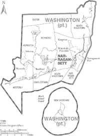
| Towns | Map of Rhode Island highlighting Washington County | |
| CDPs | ||
| Other villages |
| |
| Indian reservation | ||
Providence (capital) | ||
| Topics |
| |
| Society |
| |
| Regions | ||
| Cities | ||
| Towns |
| |
| Authority control |
|
|---|