Garfield County, Utah
Garfield County is a county in south central Utah, United States. As of the 2010 United States Census the population was 5,172,[1] making it the fifth-least populous county in Utah. Its county seat and largest city is Panguitch.[2]
Garfield County | |
|---|---|
 Garfield County Courthouse in Panguitch, December 2006 | |
 Location within the U.S. state of Utah | |
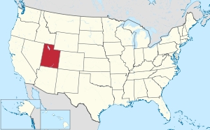 Utah's location within the U.S. | |
| Coordinates: 37.87°N 111.44°W | |
| Country | |
| State | |
| Founded | March 9, 1882 |
| Named for | James A. Garfield |
| Seat | Panguitch |
| Largest city | Panguitch |
| Area | |
| • Total | 5,208 sq mi (13,490 km2) |
| • Land | 5,175 sq mi (13,400 km2) |
| • Water | 33 sq mi (90 km2) 0.6% |
| Population (2010) | |
| • Total | 5,172 |
| • Estimate (2018) | 5,080 |
| • Density | 0.99/sq mi (0.38/km2) |
| Time zone | UTC−7 (Mountain) |
| • Summer (DST) | UTC−6 (MDT) |
| Congressional district | 2nd |
| Website | garfield |
History
The Utah Territory legislature created the county on March 9, 1882, with areas partitioned from Iron County. It was named for James A. Garfield, the twentieth President of the United States, who had died six months earlier.[3] The border with Iron County was adjusted in 1884, and Garfield County's boundaries have remained intact since then.[4]
Geography
The Colorado River, flowing southwestward through a deep gorge, forms the eastern boundary. The Dirty Devil River flows southward through the east end of the county to discharge into the Colorado at the county's border. Westward, the cliffs of tributary canyons give way to the barren stretches of the San Rafael Desert, beyond which a variety of mountains, plateaus and canyons make up the terrain. Most of Bryce Canyon National Park lies in the southwestern part of the county and the northern half of the Grand Staircase-Escalante National Monument occupies the middle of the county. A large portion of Capitol Reef National Park lies in the east-central part of the county. A very small part of Canyonlands National Park lies in the northeast corner of the county. The terrain of Garfield County is arid, rough, and carved with erosion.[5] The county terrain generally slopes to the south and to the east. The county's highest point is Mount Ellen, in Canyonlands,[6] near the county's north border, at 11,522' (3512m) ASL.[7] The county has a total area of 5,208 square miles (13,490 km2), of which 5,175 square miles (13,400 km2) is land and 33 square miles (85 km2) (0.6%) is water.[8] It is the fifth-largest county in Utah by area.
Airports[5]
- Bryce Canyon Airport (BCE)
Major highways[5]

- Utah Highway 12
- Utah Highway 22
- Utah Highway 63
- Utah Highway 95
- Utah Highway 143
- Utah Highway 276
Adjacent counties
- Wayne County - northeast
- San Juan County - east
- Kane County - south
- Iron County - west
- Beaver County - northwest
- Piute County - north
Protected areas[5]
- Bryce Canyon National Park (part)
- Canyonlands National Park (part)
- Capitol Reef National Park (part)
- Carcass Canyon Wilderness Study Area
- Dixie National Forest (part)
- Escalante Petrified Forest
- Fishlake National Forest (part)
- Glen Canyon National Recreation Area (part)
- Grand Staircase-Escalante National Monument (part)
- Mammoth Cave (US Forest Service)
Lakes[5]
- Lake Powell (part)
- Panguitch Lake
- Wide Hollow Reservoir
Demographics
| Historical population | |||
|---|---|---|---|
| Census | Pop. | %± | |
| 1890 | 2,457 | — | |
| 1900 | 3,400 | 38.4% | |
| 1910 | 3,660 | 7.6% | |
| 1920 | 4,768 | 30.3% | |
| 1930 | 4,642 | −2.6% | |
| 1940 | 5,253 | 13.2% | |
| 1950 | 4,151 | −21.0% | |
| 1960 | 3,577 | −13.8% | |
| 1970 | 3,157 | −11.7% | |
| 1980 | 3,673 | 16.3% | |
| 1990 | 3,980 | 8.4% | |
| 2000 | 4,735 | 19.0% | |
| 2010 | 5,172 | 9.2% | |
| Est. 2018 | 5,080 | [9] | −1.8% |
| US Decennial Census[10] 1790–1960[11] 1900–1990[12] 1990–2000[13] 2010–2018[1] | |||
As of the 2000 United States Census, there were 4,735 people, 1,576 households, and 1,199 families in the county. The population density was 0.91/sqmi (0.35/km²). There were 2,767 housing units at an average density of 0.53/sqmi (0.21/km²). The racial makeup of the county was 94.95% White, 0.17% Black or African American, 1.84% Native American, 0.40% Asian, 0.04% Pacific Islander, 1.12% from other races, and 1.48% from two or more races. 2.87% of the population were Hispanic or Latino of any race.
There were 1,576 households out of which 38.40% had children under the age of 18 living with them, 66.40% were married couples living together, 6.80% had a female householder with no husband present, and 23.90% were non-families. 20.50% of all households were made up of individuals and 10.10% had someone living alone who was 65 years of age or older. The average household size was 2.92 and the average family size was 3.43.
The county population contained 32.60% under the age of 18, 7.80% from 18 to 24, 23.10% from 25 to 44, 22.40% from 45 to 64, and 14.10% who were 65 years of age or older. The median age was 34 years. For every 100 females there were 104.60 males. For every 100 females age 18 and over, there were 102.20 males.
The median income for a household in the county was $35,180, and the median income for a family was $40,192. Males had a median income of $30,239 versus $20,408 for females. The per capita income for the county was $13,439. About 6.10% of families and 8.10% of the population were below the poverty line, including 8.80% of those under age 18 and 10.40% of those age 65 or over.
As of 2010 the largest self-identified ancestry groups in Garfield County are:
- English - 46.2%
- German - 14.8%
- Irish - 10.1%
- Danish - 6.6%
- Scottish - 4.9%
- Welsh - 3.9%
- Scotch-Irish - 2.5%
- Swedish - 2.3%
- Norwegian - 2.2%[14]
Politics
Garfield County has traditionally voted Republican. In no national election since 1936 has the county selected the Democratic Party candidate (as of 2016).
| Year | Republican | Democratic | Third parties |
|---|---|---|---|
| 2016 | 68.5% 1,606 | 15.3% 358 | 16.2% 380 |
| 2012 | 84.0% 1,832 | 14.1% 308 | 1.9% 42 |
| 2008 | 78.4% 1,710 | 18.6% 405 | 3.1% 67 |
| 2004 | 85.5% 1,848 | 12.2% 264 | 2.3% 50 |
| 2000 | 87.4% 1,719 | 9.0% 178 | 3.6% 71 |
| 1996 | 72.0% 1,330 | 15.3% 283 | 12.7% 234 |
| 1992 | 62.3% 1,235 | 15.6% 309 | 22.1% 439 |
| 1988 | 79.3% 1,470 | 20.0% 370 | 0.8% 15 |
| 1984 | 83.2% 1,609 | 16.3% 315 | 0.6% 11 |
| 1980 | 78.3% 1,578 | 18.6% 375 | 3.1% 62 |
| 1976 | 65.5% 1,163 | 30.4% 539 | 4.2% 74 |
| 1972 | 80.5% 1,290 | 15.1% 242 | 4.4% 71 |
| 1968 | 69.5% 1,033 | 21.1% 314 | 9.4% 140 |
| 1964 | 55.5% 821 | 44.5% 658 | |
| 1960 | 69.7% 1,083 | 30.3% 471 | |
| 1956 | 76.0% 1,115 | 24.1% 353 | |
| 1952 | 69.1% 1,065 | 30.9% 477 | |
| 1948 | 59.0% 924 | 41.0% 642 | 0.1% 1 |
| 1944 | 60.1% 842 | 39.9% 559 | 0.1% 1 |
| 1940 | 55.9% 1,030 | 44.1% 814 | |
| 1936 | 47.5% 842 | 52.4% 928 | 0.1% 2 |
| 1932 | 68.4% 1,125 | 30.0% 493 | 1.6% 26 |
| 1928 | 75.6% 1,024 | 24.0% 325 | 0.4% 5 |
| 1924 | 69.6% 823 | 26.0% 308 | 4.4% 52 |
| 1920 | 71.5% 1,023 | 27.5% 393 | 1.1% 15 |
| 1916 | 37.5% 516 | 61.3% 843 | 1.2% 17 |
| 1912 | 62.6% 673 | 23.2% 249 | 14.2% 153 |
| 1908 | 68.5% 722 | 27.5% 290 | 4.0% 42 |
| 1904 | 70.1% 679 | 26.0% 252 | 3.8% 37 |
| 1900 | 62.2% 649 | 37.8% 395 | |
| 1896 | 28.8% 249 | 71.2% 615 |
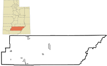
Communities[5]
See also
References
- "State & County QuickFacts". US Census Bureau. Archived from the original on June 6, 2011. Retrieved December 29, 2013.
- "Find a County". National Association of Counties. Archived from the original on May 31, 2011. Retrieved June 7, 2011.
- Gannett, Henry (1905). The Origin of Certain Place Names in the United States. Govt. Print. Off. p. 134.
- Newberry Library - Individual County Chronologies/Garfield County UT (accessed March 28, 2019)
- Garfield County UT Google Maps (accessed 28 March 2019)
- Mount Ellen Peak Google Maps (accessed 28 March 2019)
- "Utah County High Points/Garfield County. Peakbagger (accessed 29 March 2019)". Archived from the original on March 27, 2019. Retrieved March 30, 2019.
- "2010 Census Gazetteer Files". US Census Bureau. August 22, 2012. Retrieved March 27, 2015.
- "Population and Housing Unit Estimates". Retrieved October 6, 2019.
- "US Decennial Census". US Census Bureau. Retrieved March 27, 2015.
- "Historical Census Browser". University of Virginia Library. Retrieved March 27, 2015.
- Forstall, Richard L., ed. (March 27, 1995). "Population of Counties by Decennial Census: 1900 to 1990". US Census Bureau. Retrieved March 27, 2015.
- "Census 2000 PHC-T-4. Ranking Tables for Counties: 1990 and 2000" (PDF). US Census Bureau. April 2, 2001. Retrieved March 27, 2015.
- Bureau, US Census. "American FactFinder - Results". factfinder.census.gov. Archived from the original on February 13, 2020. Retrieved March 31, 2018.
- Leip, David. "Atlas of US Presidential Elections". uselectionatlas.org. Retrieved March 31, 2018.
External links

- Official website
Places adjacent to Garfield County, Utah | ||||||||||
|---|---|---|---|---|---|---|---|---|---|---|
| ||||||||||
Municipalities and communities of Garfield County, Utah, United States | ||
|---|---|---|
| Cities | Map of Utah highlighting Garfield County | |
| Towns | ||
| Unincorporated communities | ||
| Ghost towns | ||
Salt Lake City (capital) | |||||||||||||
| Topics |
|  | |||||||||||
| Society |
| ||||||||||||
| Regions | |||||||||||||
| Largest cities |
| ||||||||||||
| Counties | |||||||||||||
| Attractions |
| ||||||||||||
| Authority control |
|
|---|