Kalawao County, Hawaii
Kalawao County is a county in the U.S. state of Hawaii.[2] It is the smallest county in the 50 states both by population and land area.[3][note 1] The county encompasses the Kalaupapa or Makanalua Peninsula, on the north coast of the island of Molokaʻi. The small peninsula is isolated from the rest of Molokaʻi by cliffs over a quarter-mile high—the only land access is a mule trail.
Kalawao County | |
|---|---|
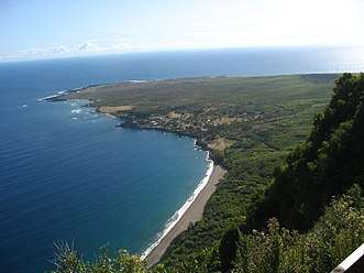 Kalaupapa peninsula | |
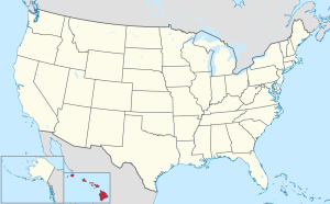
 Location within the U.S. state of Hawaii | |
 Hawaii's location within the U.S. | |
| Coordinates: 21°11′49″N 156°58′02″W | |
| Country | |
| State | |
| Founded | 1905 |
| Named for | Kalawao |
| Seat | none (administered by Hawaii Dept. of Health) |
| Largest community | Kalaupapa |
| Area | |
| • Total | 53 sq mi (140 km2) |
| • Land | 12 sq mi (30 km2) |
| • Water | 41 sq mi (110 km2) 77.3%% |
| Population | |
| • Estimate (2019) | 86[1] |
| • Density | 7.5/sq mi (2.9/km2) |
| Time zone | UTC−10 (Hawaii–Aleutian) |
| • Summer (DST) | HADT |
| Congressional district | 2nd |
Because of the small population, Kalawao County does not have the functions of other Hawaii counties. Instead, it is a judicial district of Maui County, which includes the rest of the island of Molokaʻi. The county has no elected government.
It was developed and used from 1866 to 1969 for settlements for treatment of quarantined persons with Hansen's disease (leprosy).
History
The Kingdom of Hawaiʻi, the Republic of Hawaiʻi, the territory, and the state of Hawaii exiled persons suffering from Hansen's disease to the peninsula, from 1866 to 1969. The quarantine policy was lifted after effective antibiotic treatments were developed that could be administered on an outpatient basis and patients could be rendered non-contagious.
Many of the residents chose to remain on the peninsula, as they believed their disfigurements from the illness would make reintegration into society impossible. The state promised that they could live there for the rest of their lives. No new patients, or other permanent residents, were later admitted. Visitors are permitted only as part of official tours. State law prohibits anyone under the age of 16 from visiting or living there, although exceptions have been made for children visiting their relatives.
The Kalaupapa National Historical Park was established to preserve the county's history and environment. It is coterminous with the boundaries of Kalawao County.
Government
Kalawao County lacks a local, county government. Instead, Kalawao County is administered by the Hawaii Department of Health because of the history of the settlement and current patients living there. Under Hawaiian state law, the Director of the Hawaii Department of Health, who is appointed by the Governor, also serves as the Mayor of Kalawao County.[9][10][11][12] The Mayor holds executive powers within the county; the mayor also appoints a county sheriff, who is selected from local residents.[13] The only county statutes that apply to Kalawao County directly are those on matters of health.[14]
Kalawao is part of the First Judicial Circuit, which includes the entire island of Oahu.[15] For the purpose of notarization, the designated venue for the First Judicial Circuit is "State of Hawaii, City and County of Honolulu."
Geography
Kalawao County is included in the Kahului-Wailuku-Lahaina, HI Metropolitan Statistical Area.[16][17]
According to the U.S. Census Bureau, the county has a total area of 53 square miles (140 km2), of which 12 square miles (31 km2) is land and 41 square miles (110 km2) (77.3%) is water.[18] By land area, it is the smallest true county in the United States; Falls Church, Virginia is smaller, but is an independent city with county-level governance and is not a county or part of one.
Kalaupapa Peninsula
Kalaupapa Peninsula contains the county's only settlement, Kalaupapa. The Kalaupapa Peninsula developed from lava that erupted from the ocean floor near Kauhakō Crater and spread outward, forming a low shield volcano. This was the most recent volcanic episode on the island and of the larger East Molokaʻi shield volcano, occurring after the formation of the cliffs by erosion.
Subdivisions
Kalawao County is composed of four ahupuaʻa. From west to east:[19][20]
| Ahupuaʻa | Area mi2 | Area km2 | Population | Description |
|---|---|---|---|---|
| Kalaupapa | 2.079 | 5.385 | 122 | West side of Kalaupapa peninsula. Includes a section of Molokaʻi's coast further west |
| Makanalua | 3.229 | 8.363 | 8 | Strip of land in the center of the peninsula that runs to its northern tip. Includes Kalaupapa Airport. |
| Kalawao | 3.294 | 8.531 | 9 | Eastern coast of Kalaupapa peninsula and Waialeia Valley to the southeast |
| Waikolu | 5.544 | 14.359 | 0 | Includes namesake valley. Uninhabited.[21] |
| Kalawao County | 14.146 | 36.638 | 139 |
Demographics
| Historical population | |||
|---|---|---|---|
| Census | Pop. | %± | |
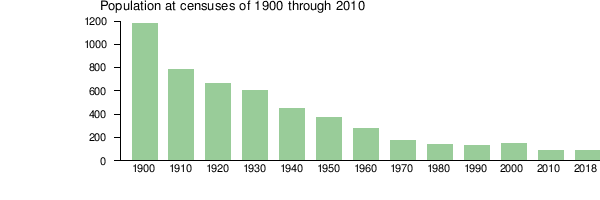
| 1900 | 1,177 | — | |
| 1910 | 785 | −33.3% | |
| 1920 | 667 | −15.0% | |
| 1930 | 605 | −9.3% | |
| 1940 | 446 | −26.3% | |
| 1950 | 340 | −23.8% | |
| 1960 | 279 | −17.9% | |
| 1970 | 172 | −38.4% | |
| 1980 | 144 | −16.3% | |
| 1990 | 130 | −9.7% | |
| 2000 | 147 | 13.1% | |
| 2010 | 90 | −38.8% | |
| Est. 2019 | 86 | [22] | −4.4% |
| U.S. Decennial Census[23] 1790-1960[24] 1900-1990[25] 1990-2000[26] 2010-2018[27] | |||
As of the census of 2000,[28] 147 people, 115 households, and 21 families resided in the county, declining to 90 inhabitants in 2010. The population density was 11 people per square mile (4/km2). The 172 housing units produced an average density of 13 per square mile (5/km2). The racial makeup of the county was 25.85% White, 17.01% Asian, 48.30% Pacific Islander, 2.72% from other races, and 6.12% from two or more races. Hispanic or Latino of any race made up 4.08%.
1.70% of households housed children under the age of 18. 16.50% were married couples living together. 2.60% had a female householder with no husband present. 80.90% were non-families. 79.10% of all households were made up of individuals and 31.30% had someone living alone who was 65 years of age or older. The average household size was 1.28 and the average family size was 2.27.
2.00% under the age of 18, 1.40% from 18 to 24, 18.40% from 25 to 44, 46.30% from 45 to 64, and 32.00% who were 65 years of age or older. The median age was 59 years. For every 100 females, there were 98.60 males. The population has declined since 1900:[29]
Current residents include 16 former patients,[30] 40 federal employees who work on preservation projects, and some state-employed health workers.[31]
Transportation
The only access to Kalawao County is by air, or by a steep mule trail that descends 1,600 feet from the rest of Molokaʻi. Kalaupapa Airport has scheduled air service to Molokaʻi Airport and to Honolulu Airport.
Freight is delivered to the county once a year, usually in July, by barge.[32]
Politics
| Year | Republican | Democratic | Others |
|---|---|---|---|
| 2016 | 5.00% 1 | 70.00% 14 | 25.00% 5 |
| 2012 | 7.41% 2 | 92.59% 25 | 0% 0 |
| 2008 | 19.35% 6 | 77.42% 24 | 3.23% 1 |
| 2004 | 35.00% 14 | 65.00% 26 | 0% 0 |
| 2000 | 24.44% 11 | 66.67% 30 | 8.89% 4 |
| 1996 | 20.63% 13 | 73.02% 46 | 6.35% 4 |
| 1992 | 32.00% 24 | 64.00% 48 | 4.00% 3 |
Like the rest of the state, Kalawao County is a stronghold for the Democratic Party, despite the small number of total votes. It was the only county in the United States where the Republican candidate in the 2016 United States Presidential election, Donald Trump, finished in third only getting one vote; 70% of Kalawao's voters chose Democratic nominee Hillary Clinton, and 25% of Kalawao voters cast their ballots for Green candidate Jill Stein, making it Stein’s strongest county nationwide in terms of vote percentage.[34]
Notes
- Swains Island in American Samoa (population 17) is the least-populous permanently-inhabited county-equivalent in the United States.[4][5][6] Kingman Reef, with a land area of 0.03 square kilometers,[7] is the smallest county-equivalent in the U.S. by land area. Additionally, by total area Manhattan is smaller, at 33.58 miles (54.04 km).[8]
References
- "U.S. Census Bureau QuickFacts: Kalawao County, Hawaii". Census Bureau QuickFacts. 2019-07-01. Retrieved 2020-04-02.
- Voss, Oscar (2012). "Is Kalawao County, on the north shore of Molokai, really a separate county?". Retrieved January 25, 2015.
- Bureau, U.S. Census. "American FactFinder - Results". Archived from the original on 2020-02-14. Retrieved 2019-05-09.
- https://www.britannica.com/place/Swains-Island Swains Island. Britannica.com. Retrieved September 5, 2019.
- https://www2.census.gov/geo/pdfs/reference/GARM/Ch4GARM.pdf States, Counties, and Statistically Equivalent Entities (Chapter 4). Census.gov. Retrieved September 5, 2019.
- https://web.archive.org/web/20170628232229/https://www.census.gov/geo/reference/codes/cou.html U.S. Census Bureau. 2010 FIPS Codes for Counties and County Equivalent Entities (archived). Retrieved September 5, 2019.
- https://www.britannica.com/place/Kingman-Reef Britannica.com. Kingman Reef. Retrieved September 5, 2019.
- 2010 Census Gazetteer Files: New York County Subdivisions Archived June 16, 2019, at the Wayback Machine, United States Census Bureau. Accessed June 19, 2017.
- Dingeman, Robbie (2002-10-31). "Smallest county to ban smoking". Honolulu Advertiser. Retrieved 2014-01-02.
- Rawlings, Nate (2013-12-12). "Hawaii Official Killed in Plane Crash". Time Magazine. Retrieved 2014-01-02.
- Uyeno, Kristine (2013-12-12). "Hawaii Official Killed in Plane Crash". KHON. Archived from the original on 2014-01-04. Retrieved 2014-01-02.
- Kakesako, Gregg K. (2013-12-12). "Pilot described 'catastrophic engine failure' in Molokai crash". Honolulu Star Advertiser. Archived from the original on 2013-12-21. Retrieved 2014-01-02.
- "Department of Health Administrative Offices". State of Hawaiʻi. Retrieved 2010-09-28.
- "Hawaii's 4 (or 5) Counties". Retrieved 2014-01-22.
- "The Judiciary - State of Hawaii - Annual Report - July 1, 1986 to June 30, 1987". p16 and p26. https://www.ncjrs.gov/pdffiles1/Digitization/109520NCJRS.pdf
- "FY 2019 LIST OF COUNTIES (AND NEW ENGLAND TOWNS) IDENTIFIED BY STATE AND METROPOLITAN AREA" (PDF). USDA Rural Development. 2019-07-19. p. 16. Retrieved 2020-04-02.
- "Metropolitan Area Look-Up Tool - Select Geography". HUD User Home Page.
- "US Gazetteer files: 2010, 2000, and 1990". United States Census Bureau. 2011-02-12. Retrieved 2011-04-23.
- "Kalaupapa Ahupua`a neighborhood in Kalaupapa, Hawaii (HI), 96742 subdivision profile - real estate, apartments, condos, homes, community, population, jobs, income, streets".
- "Waikolu Ahupua`a neighborhood in Kaunakakai, Hawaii (HI), 96742 subdivision profile - real estate, apartments, condos, homes, community, population, jobs, income, streets".
- Mark D. McCoy: The Lands of the Hina: An Archeological Overview and Assessment of Kalaupapa National Historical Park, Molokaʻi, Chapter 8: Assessment Archived 2011-09-01 at the Wayback Machine, Seite 33
- "Population and Housing Unit Estimates". Retrieved May 9, 2019.
- "U.S. Decennial Census". United States Census Bureau. Retrieved June 28, 2014.
- "Historical Census Browser". University of Virginia Library. Retrieved June 28, 2014.
- "Population of Counties by Decennial Census: 1900 to 1990". United States Census Bureau. Retrieved June 28, 2014.
- "Census 2000 PHC-T-4. Ranking Tables for Counties: 1990 and 2000" (PDF). United States Census Bureau. Retrieved June 28, 2014.
- "State & County QuickFacts". United States Census Bureau. Archived from the original on June 6, 2011. Retrieved June 28, 2014.
- "U.S. Census website". United States Census Bureau. Retrieved 2008-01-31.
- "Bureau of the Census: HAWAII. Population of Counties by Decennial Census: 1900 to 1990".
- "Planning for Kalaupapa's future means remembering its past".
- Wong, Alia (May 27, 2015). "People With Leprosy Were Exiled There—Should It Be a Tourist Destination?". The Atlantic.
- "Life Today in Kalaupapa". National Park Service. Retrieved January 22, 2014.
- Leip, David. "Dave Leip's Atlas of U.S. Presidential Elections". uselectionatlas.org. Retrieved May 26, 2017.
- "Statewide Precinct Detail" (PDF). State of Hawaii Office of Elections. Retrieved 13 March 2020.
External links
| Wikimedia Commons has media related to Kalawao County, Hawaii. |
| Wikivoyage has a travel guide for Kalawao County. |
Places adjacent to Kalawao County, Hawaii | ||||||||||
|---|---|---|---|---|---|---|---|---|---|---|
| ||||||||||
Islands, municipalities, and communities of Kalawao County, Hawaii, United States | ||
|---|---|---|
| Unincorporated communities | Map of Hawaii highlighting Kalawao County | |
| Footnotes | ‡This populated place also has portions in an adjacent county or counties | |
Honolulu (capital) | ||
| Topics | ||
| Society | ||
| Main islands | ||
| Northwestern Islands | ||
| Communities | ||
| Counties | ||
| Sovereignty Movement | ||
←—