Windham County, Connecticut
Windham County is a county located in the northeastern corner of the U.S. state of Connecticut. As of the 2010 census, the population was 118,428,[1] making it the least populous county in Connecticut. It forms the core of the region known as the Quiet Corner.
Windham County | |
|---|---|
| County of Windham | |
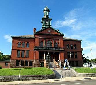 The Windham Town Hall, and former county courthouse | |
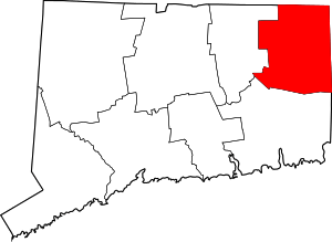 Location within the U.S. state of Connecticut | |
 Connecticut's location within the U.S. | |
| Coordinates: 41°50′N 71°59′W | |
| Country | |
| State | |
| Founded | May 12, 1726 |
| Seat | none (1960-present)
Willimantic (1893-1960) Windham (1726-1893) |
| Largest town | Windham |
| Area | |
| • Total | 521 sq mi (1,350 km2) |
| • Land | 513 sq mi (1,330 km2) |
| • Water | 8.5 sq mi (22 km2) 1.6%% |
| Population (2010) | |
| • Total | 118,428 |
| • Estimate (2019) | 116,782 |
| • Density | 230/sq mi (88/km2) |
| Time zone | UTC−5 (Eastern) |
| • Summer (DST) | UTC−4 (EDT) |
| Area code | 860 and 959 |
| Congressional district | 2nd |
Windham County is included in the Worcester, MA-CT Metropolitan Statistical Area, which is also included in the Boston-Worcester-Providence, MA-RI-NH-CT Combined Statistical Area.
The entire county is within the Quinebaug and Shetucket Rivers Valley National Heritage Corridor, as designated by the National Park Service.
History
The area that is now Windham County became of interest to the English around 1635, but went unsettled for over fifty years due to its lack of access to the shore. John Winthrop took a strong interest to this land, purchased land from the Narragansetts, and was given permission by the court of Connecticut to settle in October 1671. In 1678, a tract of land, called Joshua’s Tract (Joshua was the son of Mohegan chief Uncas), was willed to Connecticut officials, and in February 1682, it was gifted to Samuel and Daniel Mason. In 1684, 1200 acres of land was sold to Jonathan Curtis, Thomas Dudley, and Samuel, among others, by the Nipmunks.[2]
Windham County was created from Hartford and New London counties on May 12, 1726 by an act of the Connecticut General Court. The act establishing the county states:
- That the west bounds of the town of Lebanon, the north
- bounds of Coventry, the north bounds of Mansfield till it
- meet with the southwest bounds of Ashford, the west bounds
- of Ashford, the east bounds of Stafford, the Massachusetts
- line on the north, and Rhode Island line on the east, the north
- bounds of Preston, and north bounds of Norwich, containing
- the towns of Windham, Lebanon, Plainfield, Canterbury,
- Mansfield, Coventry, Pomfret, Killingly, Ashford, Voluntown
- and Mortlake, shall be one entire county, and called by the
- name of County of Windham.[3]
In May 1749, the town of Woodstock, formerly New Roxbury, Worcester County Massachusetts, was unilaterally annexed by Connecticut and assigned to Windham County. In 1785, the town of Union (incorporated in 1734) was transferred to the newly formed Tolland County. Over the next century, Windham County would lose several towns to Tolland and New London counties: Coventry to Tolland in 1786, Lebanon to New London in 1824, Columbia and Mansfield to Tolland in 1827, and Voluntown to New London in 1881. New towns were formed over the years using land from the original towns of the county: Thompson in 1785, Brooklyn and Hampton in 1786, Sterling in 1794, Chaplin in 1822, Eastford in 1847, Putnam in 1855, and Scotland in 1857. The final boundary adjustment occurred on April 7, 1885, when the boundary dispute between the towns of Windham and Mansfield was resolved.[4]
Geography
According to the U.S. Census Bureau, the county has a total area of 521 square miles (1,350 km2), of which 513 square miles (1,330 km2) is land and 8.5 square miles (22 km2) (1.6%) is water.[5]
The highest point in Windham County is Snow Hill in Ashford at 1,210 feet.
Adjacent counties
- Worcester County, Massachusetts (north)
- Providence County, Rhode Island (east)
- Kent County, Rhode Island (southeast)
- New London County (south)
- Tolland County (west)
Government
County level government in the state of Connecticut was abolished in 1960. All government affairs and services are administered by either the state or local municipality.
The office of county high sheriff was abolished by constitutional referendum in 2000. All former functions of the county sheriff's office are now carried out by the state marshals service. The last high sheriff (or official for that matter) of Windham County was Thomas W. White, who left office in 2000 due to the discontinuation of the county sheriff's departments in Connecticut.
Transportation
Roads
Major highways through Windham County include Interstate 395, which runs north-south from the New London County line at Plainfield to the Massachusetts state line at Thompson. The southern part of I-395 is part of the Connecticut Turnpike, which branches off the interstate in Killingly and runs east-west from I-395 exit 35, to U.S. Route 6 at the Rhode Island state line.
Other north-south routes include Route 12, which parallels I-395 through many local communities, Route 169, a National Scenic Byway traveling through rural communities from the New London County line in Canterbury to the Massachusetts state line in Woodstock. Other secondary north-south roads are Routes 89, 198, 97, 21, and 49.
Major east-west routes are U.S. Route 44 from the Tolland County line at Ashford to the Rhode Island state line at Putnam, and U.S. Route 6 from the Tolland County line at Windham to the Rhode Island state line at Killingly. U.S. Route 6 has short expressway segments in Windham and Killingly. Other secondary east-west roads are Routes 14, 101, 171, and 197.
Air
Windham Airport is the primary airport for the county, located 3 miles from Willimantic. Other smaller airports include Woodstock Airport and Danielson Airport.
Biking
There are many bike paths in the county. The major two trails are the Air Line State Park Trail and the Hop River State Park Trail, both these trails enter the county through Windham. The Hop River Trail ends at the Air Line Trail shortly after entering the county, while the Air Line Trail continues all the way into Putnam. Another section of the Air Line Trail is in Thompson, which continues to the border with Massachusetts which it counties as the Southern New England Trunkline Trail. Another shorter trail is the Moosup Valley State Park Trail that starts in Plainfield and continues down into the state border with Rhode Island which it continues as Washington Secondary Rail Trail. Smaller trails include the Quinebaug River Trail and the Putman River Trail.
Law enforcement
The primary law enforcement agency most Windham County towns is the Connecticut State Police, primarily Troop D based in Danielson which serves Brooklyn, Canterbury, Chaplin, Eastford, Hampton, Killingly, Pomfret, Putnam (outside the SSD), Scotland, Sterling, Thompson, Woodstock and I-395 between exit 28 and the MA border. Troop C, based in Tolland, covers the town of Ashford, and Troop K, based in Colchester, covers the town of Windham.
Only three municipalities in the county (the town of Plainfield, the Willimantic Special Services District, and the Putnam Special Services District), have their own local police departments that serve as the primary law enforcement in those areas. Eastern Connecticut State University located in Willimantic also has its own local police department (established under Connecticut General Statutes Sec. 10a-142) which serves as the primary law enforcement agency for the university campus even though they are located within the Willimantic Special Services District.
The Windham County Sheriff's Department was disbanded in 2000 and their former duties are now carried out by the Connecticut State Marshals Service.
Most towns in the county have local Constables that carry out some municipal legal and security functions.
Demographics
| Historical population | |||
|---|---|---|---|
| Census | Pop. | %± | |
| 1790 | 28,881 | — | |
| 1800 | 28,222 | −2.3% | |
| 1810 | 28,611 | 1.4% | |
| 1820 | 31,684 | 10.7% | |
| 1830 | 27,082 | −14.5% | |
| 1840 | 28,080 | 3.7% | |
| 1850 | 31,081 | 10.7% | |
| 1860 | 34,747 | 11.8% | |
| 1870 | 38,518 | 10.9% | |
| 1880 | 43,856 | 13.9% | |
| 1890 | 45,158 | 3.0% | |
| 1900 | 46,861 | 3.8% | |
| 1910 | 48,361 | 3.2% | |
| 1920 | 52,815 | 9.2% | |
| 1930 | 54,086 | 2.4% | |
| 1940 | 56,223 | 4.0% | |
| 1950 | 61,759 | 9.8% | |
| 1960 | 68,572 | 11.0% | |
| 1970 | 84,515 | 23.3% | |
| 1980 | 92,312 | 9.2% | |
| 1990 | 102,525 | 11.1% | |
| 2000 | 109,091 | 6.4% | |
| 2010 | 118,428 | 8.6% | |
| Est. 2019 | 116,782 | [6] | −1.4% |
| U.S. Decennial Census[7] 1790-1960[8] 1900-1990[9] 1990-2000[10] 2010-2018[1] | |||
As of the 2010 United States Census, there were 118,428 people, 44,810 households, and 30,343 families residing in the county.[11] The population density was 230.9 inhabitants per square mile (89.2/km2). There were 49,073 housing units at an average density of 95.7 per square mile (36.9/km2).[12] The racial makeup of the county was 89.6% white, 2.2% black or African American, 1.2% Asian, 0.5% American Indian, 4.2% from other races, and 2.3% from two or more races. Those of Hispanic or Latino origin made up 9.6% of the population.[11] In terms of ancestry, 18.8% were Irish, 13.5% were English, 11.7% were French Canadian, 11.5% were Italian, 10.2% were German, 9.3% were Polish, and 2.9% were American.[13]
Of the 44,810 households, 32.6% had children under the age of 18 living with them, 50.0% were married couples living together, 12.3% had a female householder with no husband present, 32.3% were non-families, and 24.6% of all households were made up of individuals. The average household size was 2.54 and the average family size was 3.01. The median age was 39.2 years.[11]
The median income for a household in the county was $59,370 and the median income for a family was $69,642. Males had a median income of $48,880 versus $36,873 for females. The per capita income for the county was $26,457. About 8.7% of families and 11.4% of the population were below the poverty line, including 16.0% of those under age 18 and 7.7% of those age 65 or over.[14]
Demographics breakdown by town
Data is from the 2010 United States Census and the 2006-2010 American Community Survey 5-Year Estimates.[15][16]
| Rank | Town | Per capita income |
Median household income |
Median family income |
Population | Number of households | |
|---|---|---|---|---|---|---|---|
| 1 | Eastford | Town | $36,784 | $76,786 | $93,295 | 1,749 | 690 |
| 2 | Woodstock | Town | $36,342 | $74,000 | $88,737 | 7,964 | 3,151 |
| 3 | Hampton | Town | $34,642 | $79,943 | $84,079 | 1,863 | 747 |
| 4 | Pomfret | Town | $33,910 | $68,278 | $82,917 | 4,247 | 1,582 |
| 5 | Ashford | Town | $32,842 | $69,407 | $79,157 | 4,317 | 1,716 |
| 6 | Chaplin | Town | $32,188 | $62,679 | $72,426 | 2,305 | 920 |
| 7 | Canterbury | Town | $30,453 | $70,902 | $84,093 | 5,132 | 1,934 |
| 8 | Scotland | Town | $29,371 | $75,417 | $79,722 | 1,726 | 637 |
| 9 | Thompson | Town | $27,222 | $60,951 | $74,613 | 9,458 | 3,730 |
| 10 | Putnam | Town | $26,506 | $51,180 | $61,168 | 9,584 | 3,950 |
| 11 | Sterling | Town | $25,557 | $64,500 | $74,405 | 3,830 | 1,383 |
| 12 | Killingly | Town | $25,215 | $53,192 | $65,496 | 17,370 | 6,749 |
| 13 | Brooklyn | Town | $25,124 | $68,851 | $76,224 | 8,210 | 2,989 |
| 14 | Plainfield | Town | $24,825 | $61,500 | $69,096 | 15,405 | 5,726 |
| 15 | Danielson | Borough | $22,798 | $55,097 | $56,831 | 4,051 | 1,627 |
| 16 | Windham | Town | $20,272 | $40,063 | $48,145 | 25,268 | 8,906 |
Politics
Windham County had trended Democratic at the presidential level over the last quarter century, until it voted for Donald Trump in 2016.
| Year | GOP | DEM | Others |
|---|---|---|---|
| 2016 | 50.7% 25,747 | 42.9% 21,792 | 6.5% 3,284 |
| 2012 | 42.4% 19,768 | 55.7% 25,957 | 1.9% 863 |
| 2008 | 41.7% 21,210 | 56.4% 28,673 | 1.9% 961 |
| 2004 | 45.7% 22,324 | 52.1% 25,477 | 2.2% 1,060 |
| 2000 | 38.0% 16,708 | 54.6% 24,023 | 7.4% 3,232 |
| 1996 | 31.0% 13,237 | 51.7% 22,077 | 17.4% 7,432 |
| 1992 | 30.8% 14,963 | 40.4% 19,621 | 28.8% 14,004 |
| 1988 | 50.9% 21,268 | 47.9% 20,005 | 1.3% 526 |
| 1984 | 61.6% 24,917 | 38.0% 15,351 | 0.5% 187 |
| 1980 | 47.8% 18,852 | 39.2% 15,444 | 13.0% 5,123 |
| 1976 | 46.1% 17,643 | 53.3% 20,380 | 0.6% 239 |
| 1972 | 56.0% 21,621 | 42.7% 16,459 | 1.3% 504 |
| 1968 | 40.8% 14,162 | 55.1% 19,098 | 4.1% 1,414 |
| 1964 | 26.4% 9,080 | 73.5% 25,238 | 0.1% 19 |
| 1960 | 43.0% 15,180 | 57.0% 20,105 | 0.0% 0 |
| 1956 | 59.6% 20,029 | 40.4% 13,553 | 0.0% 0 |
| 1952 | 53.5% 17,979 | 46.3% 15,535 | 0.2% 74 |
| 1948 | 46.5% 13,692 | 52.4% 15,433 | 1.1% 328 |
| 1944 | 44.5% 12,032 | 55.1% 14,886 | 0.4% 104 |
| 1940 | 44.6% 12,079 | 55.3% 14,989 | 0.2% 43 |
| 1936 | 46.0% 11,466 | 50.6% 12,605 | 3.4% 857 |
| 1932 | 46.4% 9,522 | 52.6% 10,801 | 1.0% 206 |
| 1928 | 51.4% 10,040 | 48.3% 9,447 | 0.3% 66 |
| 1924 | 59.6% 9,488 | 34.4% 5,475 | 5.9% 945 |
| 1920 | 62.0% 8,594 | 36.6% 5,071 | 1.5% 207 |
| 1916 | 51.9% 4,259 | 46.2% 3,797 | 1.9% 157 |
| 1912 | 41.8% 3,051 | 39.5% 2,881 | 18.7% 1,363 |
| 1908 | 63.6% 4,960 | 33.6% 2,623 | 2.8% 219 |
| 1904 | 61.8% 4,934 | 35.5% 2,833 | 2.7% 214 |
| 1900 | 65.0% 4,951 | 33.6% 2,560 | 1.4% 106 |
| 1896 | 70.5% 3,576 | 20.6% 1,044 | 8.9% 452 |
| 1892 | 49.0% 2,655 | 48.1% 2,606 | 3.0% 160 |
| 1888 | 50.9% 2,734 | 44.7% 2,402 | 4.4% 235 |
| 1884 | 53.6% 2,716 | 43.4% 2,197 | 3.0% 150 |
Communities
Boroughs are incorporated portions of one or more towns with separate borough councils, zoning boards, and borough officials. Villages are named localities, but have no separate corporate existence from the towns they are in.
References
- "State & County QuickFacts". United States Census Bureau. Archived from the original on June 25, 2011. Retrieved June 11, 2014.
- Bayles, Richard M. (1889). History of Windham County, Connecticut. New York: W.W. Preston & Co. pp. 23–33.
- "CCR: Volume 07, Page 11". Archived from the original on July 20, 2011. Retrieved June 17, 2008.
- Newberry Library -- Connecticut Atlas of Historical County Boundaries Archived November 10, 2013, at the Wayback Machine
- "US Gazetteer files: 2010, 2000, and 1990". United States Census Bureau. 2011-02-12. Retrieved 2011-04-23.
- "Population and Housing Unit Estimates". Retrieved May 8, 2019.
- "U.S. Decennial Census". United States Census Bureau. Retrieved June 11, 2014.
- "Historical Census Browser". University of Virginia Library. Retrieved June 11, 2014.
- "Population of Counties by Decennial Census: 1900 to 1990". United States Census Bureau. Retrieved June 11, 2014.
- "Census 2000 PHC-T-4. Ranking Tables for Counties: 1990 and 2000" (PDF). United States Census Bureau. Retrieved June 11, 2014.
- "DP-1 Profile of General Population and Housing Characteristics: 2010 Demographic Profile Data". United States Census Bureau. Archived from the original on 2020-02-13. Retrieved 2016-01-12.
- "Population, Housing Units, Area, and Density: 2010 - County". United States Census Bureau. Archived from the original on 2020-02-13. Retrieved 2016-01-12.
- "DP02 SELECTED SOCIAL CHARACTERISTICS IN THE UNITED STATES – 2006-2010 American Community Survey 5-Year Estimates". United States Census Bureau. Archived from the original on 2020-02-13. Retrieved 2016-01-12.
- "DP03 SELECTED ECONOMIC CHARACTERISTICS – 2006-2010 American Community Survey 5-Year Estimates". United States Census Bureau. Archived from the original on 2020-02-13. Retrieved 2016-01-12.
- "SELECTED ECONOMIC CHARACTERISTICS 2006-2010 American Community Survey 5-Year Estimates". U.S. Census Bureau. Archived from the original on 2020-02-12. Retrieved 2012-11-25.
- "Profile of General Population and Housing Characteristics: 2010 Demographic Profile Data". U.S. Census Bureau. Archived from the original on 2019-05-21. Retrieved 2012-11-25.
- Leip, David. "Dave Leip's Atlas of U.S. Presidential Elections". uselectionatlas.org. Retrieved May 26, 2017.
External links
- Windham County Sheriff's Department
- National Register of Historic Places listing for Windham Co., Connecticut
Places adjacent to Windham County, Connecticut | ||||||||||
|---|---|---|---|---|---|---|---|---|---|---|
| ||||||||||
Municipalities and communities of Windham County, Connecticut, United States | ||
|---|---|---|
| Towns | | |
| Borough | ||
| Former cities |
| |
| Other communities |
| |

| Authority control |
|
|---|