Mineral County, Colorado
Mineral County is one of the 64 counties in the U.S. state of Colorado. As of the 2010 census, the population was 712,[1] making it the second-least populous county in Colorado, behind San Juan County. The county seat and only incorporated municipality in the county is Creede.[2] The county was named for the many valuable minerals found in the mountains and streams of the area.
Mineral County | |
|---|---|
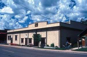 The Mineral County Courthouse in Creede | |
 Location within the U.S. state of Colorado | |
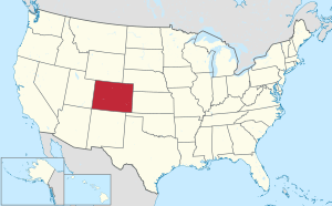 Colorado's location within the U.S. | |
| Coordinates: 37°41′N 106°56′W | |
| Country | |
| State | |
| Founded | March 27, 1893 |
| Seat | Creede |
| Largest town | Creede |
| Area | |
| • Total | 878 sq mi (2,270 km2) |
| • Land | 876 sq mi (2,270 km2) |
| • Water | 2.0 sq mi (5 km2) 0.2%% |
| Population | |
| • Estimate (2019) | 769 |
| • Density | 0.8/sq mi (0.3/km2) |
| Time zone | UTC−7 (Mountain) |
| • Summer (DST) | UTC−6 (MDT) |
| Congressional district | 3rd |
| Website | www |

Geography
According to the U.S. Census Bureau, the county has a total area of 878 square miles (2,270 km2), of which 876 square miles (2,270 km2) is land and 2.0 square miles (5.2 km2) (0.2%) is water.[3]
Adjacent counties
- Saguache County - northeast
- Rio Grande County - east
- Archuleta County - south
- Hinsdale County - west
National protected areas
Trails and byways
- Colorado Trail
- Continental Divide National Scenic Trail
- Lake Fork National Recreation Trail
- Silver Thread Scenic Byway
Demographics
| Historical population | |||
|---|---|---|---|
| Census | Pop. | %± | |
| 1900 | 1,913 | — | |
| 1910 | 1,239 | −35.2% | |
| 1920 | 779 | −37.1% | |
| 1930 | 640 | −17.8% | |
| 1940 | 975 | 52.3% | |
| 1950 | 698 | −28.4% | |
| 1960 | 424 | −39.3% | |
| 1970 | 786 | 85.4% | |
| 1980 | 804 | 2.3% | |
| 1990 | 558 | −30.6% | |
| 2000 | 831 | 48.9% | |
| 2010 | 712 | −14.3% | |
| Est. 2019 | 769 | [4] | 8.0% |
| U.S. Decennial Census[5] 1790-1960[6] 1900-1990[7] 1990-2000[8] 2010-2015[1] | |||
At the 2000 census, there were 831 people in 377 households, including 251 families, in the county. The population density was 1 people per square mile (0/km²). There were 1,119 housing units at an average density of 1 per square mile (0/km²). The racial makeup of the county was 96.87% White, 0.84% Native American, 0.12% from other races, and 2.17% from two or more races. 2.05% of the population were Hispanic or Latino of any race.
Of the 377 households 22.30% had children under the age of 18 living with them, 57.00% were married couples living together, 5.80% had a female householder with no husband present, and 33.40% were non-families. 28.10% of households were one person and 9.80% were one person aged 65 or older. The average household size was 2.20 and the average family size was 2.70.
The age distribution was 20.50% under the age of 18, 4.70% from 18 to 24, 24.80% from 25 to 44, 32.70% from 45 to 64, and 17.30% 65 or older. The median age was 45 years. For every 100 females there were 104.20 males. For every 100 females age 18 and over, there were 99.10 males.
The median household income was $34,844 and the median family income was $40,833. Males had a median income of $28,750 versus $19,375 for females. The per capita income for the county was $24,475. About 9.30% of families and 10.20% of the population were below the poverty line, including 18.70% of those under age 18 and 10.60% of those age 65 or over.
Mineral County has an extremely high proportion of land under federal ownership, with 96% of the county under the management of the federal government (It houses an office of, and is surrounded by, the Rio Grande National Forest).
2015
As of 2015 the largest self-reported ancestry groups in Mineral County, Colorado are:[9]
| Largest ancestries (2015) | Percent |
|---|---|
| English | 22.5% |
| German | 19.9% |
| Irish | 13.9% |
| "American" | 7.5% |
Politics
| Year | Republican | Democratic | Others |
|---|---|---|---|
| 2016 | 52.8% 344 | 36.4% 237 | 10.9% 71 |
| 2012 | 52.9% 344 | 44.8% 291 | 2.3% 15 |
| 2008 | 53.6% 334 | 43.3% 270 | 3.1% 19 |
| 2004 | 61.9% 383 | 36.7% 227 | 1.5% 9 |
| 2000 | 60.5% 294 | 34.6% 168 | 4.9% 24 |
| 1996 | 40.0% 179 | 43.0% 192 | 17.0% 76 |
| 1992 | 35.4% 159 | 38.1% 171 | 26.5% 119 |
| 1988 | 55.1% 217 | 44.2% 174 | 0.8% 3 |
| 1984 | 72.6% 333 | 25.5% 117 | 2.0% 9 |
| 1980 | 60.2% 271 | 27.8% 125 | 12.0% 54 |
| 1976 | 55.6% 235 | 39.5% 167 | 5.0% 21 |
| 1972 | 71.0% 247 | 27.6% 96 | 1.4% 5 |
| 1968 | 43.8% 116 | 47.6% 126 | 8.7% 23 |
| 1964 | 30.2% 89 | 69.2% 204 | 0.7% 2 |
| 1960 | 47.9% 146 | 51.8% 158 | 0.3% 1 |
| 1956 | 62.7% 168 | 36.9% 99 | 0.4% 1 |
| 1952 | 67.9% 209 | 31.8% 98 | 0.3% 1 |
| 1948 | 43.0% 144 | 56.7% 190 | 0.3% 1 |
| 1944 | 52.8% 170 | 46.6% 150 | 0.6% 2 |
| 1940 | 45.1% 229 | 53.7% 273 | 1.2% 6 |
| 1936 | 30.2% 126 | 68.4% 285 | 1.4% 6 |
| 1932 | 29.6% 112 | 55.4% 210 | 15.0% 57 |
| 1928 | 41.1% 144 | 53.4% 187 | 5.4% 19 |
| 1924 | 46.0% 150 | 31.0% 101 | 23.0% 75 |
| 1920 | 49.3% 183 | 39.4% 146 | 11.3% 42 |
| 1916 | 29.2% 135 | 60.0% 278 | 10.8% 50 |
| 1912 | 28.9% 186 | 44.5% 286 | 26.6% 171 |
Communities

Town
Unincorporated Communities
- Spar City
- Wagon Wheel Gap
Ghost Towns
- Bachelor City
- Weaver
See also
References
- "State & County QuickFacts". United States Census Bureau. Archived from the original on June 6, 2011. Retrieved June 8, 2014.
- "Find a County". National Association of Counties. Archived from the original on 2011-05-31. Retrieved 2011-06-07.
- "US Gazetteer files: 2010, 2000, and 1990". United States Census Bureau. 2011-02-12. Retrieved 2011-04-23.
- "Population and Housing Unit Estimates". Retrieved December 12, 2019.
- "U.S. Decennial Census". United States Census Bureau. Retrieved June 8, 2014.
- "Historical Census Browser". University of Virginia Library. Archived from the original on August 11, 2012. Retrieved June 8, 2014.
- "Population of Counties by Decennial Census: 1900 to 1990". United States Census Bureau. Archived from the original on July 31, 2014. Retrieved June 8, 2014.
- "Census 2000 PHC-T-4. Ranking Tables for Counties: 1990 and 2000" (PDF). United States Census Bureau. Archived (PDF) from the original on December 18, 2014. Retrieved June 8, 2014.
- Bureau, U.S. Census. "American FactFinder - Results". factfinder.census.gov. Archived from the original on 13 February 2020. Retrieved 7 May 2018.
- Leip, David. "Dave Leip's Atlas of U.S. Presidential Elections". uselectionatlas.org. Archived from the original on June 4, 2011. Retrieved May 26, 2017.
Further reading
- Foley, N.K. et al. (1993). Mineralogy, mineral chemistry, and paragenesis of gold, silver, and base-metal ores of the North Amethyst vein system, San Juan Mountains, Mineral County, Colorado [U.S. Geological Survey Professional Paper 1537]. Washington, D.C.: U.S. Department of the Interior, U.S. Geological Survey.
External links
| Wikimedia Commons has media related to Mineral County, Colorado. |
- Official Website of Mineral County, Colorado
- Creede and Mineral County information
- Colorado County Evolution by Don Stanwyck
- Colorado Historical Society
Places adjacent to Mineral County, Colorado | ||||||||||
|---|---|---|---|---|---|---|---|---|---|---|
| ||||||||||
Municipalities and communities of Mineral County, Colorado, United States | ||
|---|---|---|
| Town | Map of Colorado highlighting Mineral County | |
| Unincorporated community | ||

| Authority control |
|
|---|