Burlington County, New Jersey
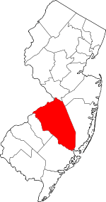
Burlington County is a county in the U.S. state of New Jersey. The county is the largest in New Jersey by area. Its county seat is Mount Holly.[1] As of the 2019 Census Bureau estimate, the county's population was 445,349, making it the 11th-largest of the state's 21 counties, representing a 0.4% decrease[3][4][5] from the 2010 United States Census, when the population was enumerated at 448,734,[6] in turn an increase of 25,340 (6.0%) from the 423,394 enumerated in the 2000 Census.[7] The most-populous place was Evesham Township, with 45,538 residents at the time of the 2010 Census, while Washington Township covered 102.71 square miles (266.0 km2), the largest area of any municipality in Burlington County.[8]
Burlington County | |
|---|---|
.JPG) Breidenhart, in Moorestown, was placed on the National Register of Historic Places in 1977. | |
 Flag | |
 Location within the U.S. state of New Jersey | |
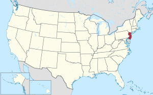 New Jersey's location within the U.S. | |
| Coordinates: 39.88°N 74.67°W | |
| Country | |
| State | |
| Founded | May 17, 1694 |
| Named for | Bridlington, England |
| Seat | Mount Holly[1] |
| Largest municipality | Evesham Township (population) Washington Township (area) |
| Government | |
| • Freeholder Director | Tom Pullion (D, term ends December 31, 2019) |
| Area | |
| • Total | 819.84 sq mi (2,123.4 km2) |
| • Land | 798.58 sq mi (2,068.3 km2) |
| • Water | 21.26 sq mi (55.1 km2) 2.59% |
| Population (2010) | |
| • Total | 448,734[2] |
| • Estimate (2019) | 445,349[2] |
| Congressional districts | 1st, 2nd, 3rd |
| Website | www |
Burlington County is part of the Delaware Valley area, located east of the Delaware River. However, the county stretches across the state, and its southeast corner reaches tidal estuaries leading to southern New Jersey's Great Bay, which separates the county from the Atlantic Ocean.
History
Anglo-European records of Burlington County date to 1681, when its court was established in the Province of West Jersey. The county was formed on May 17, 1694, "by the union of the first and second Tenths."[9] The county was named for Bridlington, a town in England.[10][11][12] Burlington County was also the seat of government for the Province of West Jersey until its amalgamation with East Jersey in 1702, forming the Province of New Jersey. The county was much larger and was partitioned to form additional counties as the population increased. In 1714 one partition to the north became Hunterdon County, which itself was later partitioned to form three additional counties. The county seat had been in Burlington but, as the population increased in the interior, away from the Delaware River, a more central location was needed, and the seat of government was moved to Mount Holly in 1793.[13]
19th century
Increasing industrialization led to improvements in transportation which increased to profitability of agriculture in the county. Population increases in the coastal communities due to successful international trade and ship repair led to road improvements throughout the county.
Geography
According to the 2010 Census, the county had an area of 819.84 square miles (2,123.4 km2), including 798.58 square miles (2,068.3 km2) of land (97.4%) and 21.26 square miles (55.1 km2) of water (2.6%).[14]
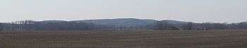
Most of the county's land is coastal and alluvial plain with little relief. There are a few anomalous hills, such as Apple Pie Hill and Arney's Mount, the highest of not only the county but also among the highest in South Jersey at approximately 240 feet (73 m) above sea level.[15] The low point is sea level along the Delaware and Mullica rivers.
Most of the land is dotted with rivers, streams, and wetlands. Some of the largest and most important rivers in Burlington County include Rancocas Creek, Assiscunk Creek, Pennsauken Creek, Mullica River, Batsto River and Wading River.
The county borders Atlantic County, Camden County, Mercer County, Monmouth County and Ocean County in New Jersey; and both Bucks County and Philadelphia County across the Delaware River in Pennsylvania.[16]
Climate and weather
| Mount Holly, New Jersey | ||||||||||||||||||||||||||||||||||||||||||||||||||||||||||||
|---|---|---|---|---|---|---|---|---|---|---|---|---|---|---|---|---|---|---|---|---|---|---|---|---|---|---|---|---|---|---|---|---|---|---|---|---|---|---|---|---|---|---|---|---|---|---|---|---|---|---|---|---|---|---|---|---|---|---|---|---|
| Climate chart (explanation) | ||||||||||||||||||||||||||||||||||||||||||||||||||||||||||||
| ||||||||||||||||||||||||||||||||||||||||||||||||||||||||||||
| ||||||||||||||||||||||||||||||||||||||||||||||||||||||||||||
Average temperatures in the county seat of Mount Holly have ranged from a low of 22 °F (−6 °C) in January to a high of 87 °F (31 °C) in July, although a record low of −25 °F (−32 °C) was recorded in February 1934 and a record high of 104 °F (40 °C) was recorded in July 1936. Average monthly precipitation ranged from 2.92 inches (74 mm) in February to 4.87 inches (124 mm) in August. According to the Köppen climate classification, Burlington County has a humid subtropical climate (Cfa), with relatively cool to cold winters and hot summers.
Severe weather is common in the warm months. Hurricanes have struck Burlington County on occasion, but tornadoes are uncommon. Severe thunderstorms, however, are common during the warm season. Snowfall is typical in the winter, with the snowfall averages in the county ranging from about 18 to 22 inches. The nearby Atlantic Ocean moderates Burlington County's climate, and rain is common year-round. The county seat receives about 41 inches of rain per year.
Another interesting weather phenomena that occurs in Burlington County is radiative cooling in the Pine Barrens, a large pine forest and reserve that takes up a good portion of Southern and Eastern Burlington County. Due to sandy soil, on clear and dry nights these areas might be 10 to 15 °F (−12 to −9 °C) colder than the surrounding areas, and there is a shorter frost-free season in these places. The sandy soil of the Pinelands loses heat much faster than the other soils or urban surfaces (concrete, asphalt) in the region, and so achieves a much lower temperature at night than the rest of the county. This effect is far less pronounced on moist, cloudy, or windy nights, as these three factors greatly reduce the radiative cooling of the sandy soil.[17]
| Climate data for {{{location}}} | |||||||||||||
|---|---|---|---|---|---|---|---|---|---|---|---|---|---|
| Month | Jan | Feb | Mar | Apr | May | Jun | Jul | Aug | Sep | Oct | Nov | Dec | Year |
| Record high °F (°C) | 72 (22) |
74 (23) |
90 (32) |
96 (36) |
98 (37) |
98 (37) |
103 (39) |
102 (39) |
95 (35) |
87 (31) |
78 (26) |
73 (23) |
103 (39) |
| Mean maximum °F (°C) | 63 (17) |
62 (17) |
74 (23) |
87 (31) |
89 (32) |
94 (34) |
96 (36) |
94 (34) |
89 (32) |
80 (27) |
73 (23) |
64 (18) |
98 (37) |
| Average high °F (°C) | 40 (4) |
43.5 (6.4) |
52 (11) |
63 (17) |
73 (23) |
81.8 (27.7) |
86.5 (30.3) |
84.1 (28.9) |
77.1 (25.1) |
66 (19) |
55.5 (13.1) |
44.2 (6.8) |
63.9 (17.7) |
| Daily mean °F (°C) | 32 (0) |
34.6 (1.4) |
42.5 (5.8) |
52.3 (11.3) |
61.8 (16.6) |
71 (22) |
75.8 (24.3) |
73.6 (23.1) |
66.1 (18.9) |
55.1 (12.8) |
46 (8) |
36 (2) |
53.9 (12.2) |
| Average low °F (°C) | 24 (−4) |
25.7 (−3.5) |
32.9 (0.5) |
41.6 (5.3) |
50.6 (10.3) |
60.1 (15.6) |
65.2 (18.4) |
63 (17) |
55.1 (12.8) |
44.3 (6.8) |
36.5 (2.5) |
27.7 (−2.4) |
43.9 (6.6) |
| Mean minimum °F (°C) | 7 (−14) |
9 (−13) |
17 (−8) |
28 (−2) |
37 (3) |
48 (9) |
56 (13) |
54 (12) |
44 (7) |
31 (−1) |
22 (−6) |
14 (−10) |
5 (−15) |
| Record low °F (°C) | −6 (−21) |
−3 (−19) |
3 (−16) |
23 (−5) |
32 (0) |
43 (6) |
50 (10) |
51 (11) |
37 (3) |
26 (−3) |
17 (−8) |
2 (−17) |
−6 (−21) |
| Average precipitation inches (mm) | 2.89 (73) |
2.78 (71) |
4.42 (112) |
3.70 (94) |
4.07 (103) |
4.46 (113) |
4.78 (121) |
4.68 (119) |
4.02 (102) |
3.26 (83) |
3.42 (87) |
3.73 (95) |
46.21 (1,174) |
| Average precipitation days | 10 | 11 | 11 | 12 | 12 | 11 | 11 | 11 | 8 | 11 | 9 | 12 | 125 |
| Average snowy days | 4 | 5 | 2 | 0 | 0 | 0 | 0 | 0 | 0 | 0 | 0 | 2 | 15 |
| Source 1: [18] | |||||||||||||
| Source 2: [19] | |||||||||||||
Demographics
| Historical population | |||
|---|---|---|---|
| Census | Pop. | %± | |
| 1790 | 18,095 | — | |
| 1800 | 21,521 | 18.9% | |
| 1810 | 24,979 | 16.1% | |
| 1820 | 28,822 | 15.4% | |
| 1830 | 31,107 | 7.9% | |
| 1840 | 32,831 | * | 5.5% |
| 1850 | 43,203 | 31.6% | |
| 1860 | 49,730 | 15.1% | |
| 1870 | 53,639 | 7.9% | |
| 1880 | 55,402 | 3.3% | |
| 1890 | 58,528 | 5.6% | |
| 1900 | 58,241 | −0.5% | |
| 1910 | 66,565 | 14.3% | |
| 1920 | 81,770 | 22.8% | |
| 1930 | 93,541 | 14.4% | |
| 1940 | 97,013 | 3.7% | |
| 1950 | 135,910 | 40.1% | |
| 1960 | 224,499 | 65.2% | |
| 1970 | 323,132 | 43.9% | |
| 1980 | 362,542 | 12.2% | |
| 1990 | 395,066 | 9.0% | |
| 2000 | 423,394 | 7.2% | |
| 2010 | 448,734 | 6.0% | |
| Est. 2019 | 445,349 | [3][4][5] | −0.8% |
| Historical sources: 1790-1990[20] 1970-2010[8] 2000[21] 2010-2019[6] * = Lost territory in previous decade.[9] | |||
2010 Census
The 2010 United States Census counted 448,734 people, 166,318 households, and 117,254.190 families in the county. The population density was 561.9 per square mile (217.0/km2). There were 175,615 housing units at an average density of 219.9 per square mile (84.9/km2). The racial makeup of the county was 73.84% (331,342) White, 16.60% (74,505) Black or African American, 0.22% (985) Native American, 4.32% (19,395) Asian, 0.05% (219) Pacific Islander, 2.05% (9,193) from other races, and 2.92% (13,095) from two or more races. Hispanic or Latino of any race were 6.42% (28,831) of the population.[6]
The 166,318 households accounted 31.3% with children under the age of 18 living with them; 54.3% were married couples living together; 12% had a female householder with no husband present, and 29.5% were non-families. Of all households, 24.4% were made up of individuals, and 9.5% had someone living alone who was 65 years of age or older. The average household size was 2.62 and the average family size was 3.14.[6]
In the county, the population age was spread out with 23.2% under the age of 18, 8.3% from 18 to 24, 25.4% from 25 to 44, 29.2% from 45 to 64, and 13.9% who were 65 years of age or older. The median age was 40.4 years. For every 100 females, the population had 96.6 males. For every 100 females ages 18 and older there were 94.6 males.[6]
2000 Census
As of the 2000 United States Census[22] there were 423,394 people, 154,371 households, and 111,610 families residing in the county. The population density was 526 people per square mile (203/km²). There were 161,311 housing units at an average density of 200 per square mile (77/km²). The county's racial makeup was 78.39% White, 15.13% Black or African American, 0.21% Native American, 2.69% Asian, 0.03% Pacific Islander, 1.48% from other races, and 2.07% from two or more races. 4.16% of the population were Hispanic or Latino of any race.[21][23] Among those residents listing their ancestry, 21.2% of residents were of Irish, 19.1% German, 16.3% Italian, 10.8% English and 7.1% Polish ancestry according to Census 2000.[23][24]
There were 154,371 households, of which 34.30% had children under the age of 18 living with them, 57.70% were married couples living together, 10.90% had a female householder with no husband present, and 27.70% were non-families. 22.90% of all households were made up of individuals and 8.50% had someone living alone who was 65 years of age or older. The average household size was 2.65 and the average family size was 3.14.[21]
The county's population was spread out, with 25.20% under the age of 18, 7.50% from 18 to 24, 31.50% from 25 to 44, 23.30% from 45 to 64, and 12.60% who were 65 years of age or older. The median age was 37 years. For every 100 females there were 97.90 males. For every 100 females age 18 and over, there were 95.60 males.[21]
The county's median household income was $58,608, and the median family income was $67,481. Males had a median income of $46,381 versus $32,228 for females. The county's per capita income was $26,339. About 3.2% of families and 4.7% of the population were below the poverty line, including 5.5% of those under age 18 and 4.9% of those age 65 or over.[23][25]
Economy
Based on data from the Bureau of Economic Analysis, Burlington County had a gross domestic product (GDP) of $25.2 billion in 2018, which was ranked 10th in the state and represented an increase of 2.0% from the previous year.[26]
In 2015, the county had a per capita personal income of $55,227, the tenth-highest in New Jersey and ranked 228th of 3,113 counties in the United States.[27][28] The Bureau of Economic Analysis ranked the county as having the 158th-highest per capita income of all 3,113 counties in the United States (and the 11th-highest in New Jersey) as of 2009.[29]
Government
Burlington County is governed by a board of chosen freeholders consisting of five members elected at-large by the voters in partisan elections that serve staggered three-year terms, with one or two seats up for election each year in a three-year cycle. Burlington County Board of Chosen Freeholders have both administrative and policy-making powers. Each Burlington County Freeholder oversees a particular area of service: Administration & Natural Resources; Education & Justice; Public Works & Veteran Services; Public Safety & Health and Human Services; and Hospital and Medical Services & Elections.[30] In 2016, freeholders were paid $10,553 and the freeholder director was paid an annual salary of $11,553; the freeholder salaries are the lowest of the state's 21 counties.[31]
As of 2020, Burlington County's Freeholders are:[30][32]
- Deputy Director Tom Pullion (D, Edgewater Park, 2020)[33]
- Balvir Singh (D, Burlington Township, 2020)[34]
- Director Felicia Hopson (D, Willingboro Township, 2021)[35]
- Daniel J. O’Connell (D, Delran Township, 2021)[36]
- Linda A. Hynes (D, Westampton Township, 2022)[37]
Pursuant to Article VII Section II of the New Jersey State Constitution, each county in New Jersey is required to have three elected administrative officials known as "constitutional officers." These officers are the County Clerk and County Surrogate (both elected for five-year terms of office) and the County Sheriff (elected for a three-year term).[38] Burlington County's Constitutional Officers are:
- Surrogate Mary Ann C. O'Brien (R, Medford, 2021)[39][40]
- Sheriff Anthony Basantis (D, Burlington Township, 2022)[41][42]
- County Clerk Joanne Schwartz (D, Southampton Township, 2023)[43][44]
The Burlington County Prosecutor is Scott A. Coffina of the Marlton section of Evesham Township who was nominated by Governor of New Jersey Chris Christie and sworn into office in March 2017 after confirmation by the New Jersey Senate.[45][46]
Burlington County constitutes Vicinage 3 of the New Jersey Superior Court and is seated at the Burlington County Courts Facility and County Office Building in Mount Holly, with additional space in the Olde Courthouse and Rancocas Building, also in Mount Holly; the Assignment Judge for Vicinage 3 is Ronald E. Bookbinder.[47]
Three federal Congressional Districts cover the county. Most of the county is in the 3rd District, with the southeastern portion being in the 2nd District and a sliver in the west being in the 1st District.[48][49] For the 116th United States Congress, New Jersey's First Congressional District is represented by Donald Norcross (D, Camden).[50][51] For the 116th United States Congress, New Jersey's Second Congressional District is represented by Jeff Van Drew (R, Dennis Township).[52] For the 116th United States Congress, New Jersey's 3rd Congressional District is represented by Andy Kim (D, Bordentown).[53]
The county is part of the 6th, 7th, 8th, 9th and 12th Districts in the New Jersey Legislature.[54]
The county is also home to the majority of 42,000-acre (17,000 ha) megabase, Joint Base McGuire-Dix-Lakehurst, the entire Air Force Activity / Headquarters of JB MDL McGuire Air Force Base, and all of the main portions of the Army Support Activity, Fort Dix and most training grounds / shooting ranges lie within the county borders in New Hanover, North Hanover, Pemberton, and Springfield townships.[55][56]
Politics
| Year | Republican | Democratic | Third Parties |
|---|---|---|---|
| 2016 | 40.3% 89,272 | 55.0% 121,725 | 4.7% 10,286 |
| 2012 | 40.4% 87,401 | 58.4% 126,377 | 1.2% 2,561 |
| 2008 | 40.1% 89,626 | 58.6% 131,219 | 1.3% 2,930 |
| 2004 | 46.1% 95,936 | 53.1% 110,411 | 0.8% 1,609 |
| 2000 | 40.7% 72,254 | 56.1% 99,506 | 3.3% 5,781 |
| 1996 | 35.0% 57,337 | 51.9% 85,086 | 13.1% 21,386 |
| 1992 | 36.8% 63,709 | 42.0% 72,845 | 21.2% 36,803 |
| 1988 | 58.3% 87,416 | 40.8% 61,140 | 0.9% 1,393 |
| 1984 | 60.8% 89,815 | 38.9% 57,467 | 0.3% 377 |
| 1980 | 51.9% 68,415 | 38.0% 50,083 | 10.0% 13,211 |
| 1976 | 48.1% 60,960 | 49.9% 63,309 | 2.0% 2,551 |
| 1972 | 62.0% 70,805 | 36.3% 41,520 | 1.7% 1,935 |
| 1968 | 46.3% 46,177 | 41.8% 41,651 | 11.9% 11,919 |
| 1964 | 35.1% 31,215 | 64.8% 57,638 | 0.1% 92 |
| 1960 | 51.7% 42,112 | 48.2% 39,321 | 0.1% 106 |
| 1956 | 61.1% 38,145 | 38.8% 24,258 | 0.1% 68 |
| 1952 | 54.2% 30,202 | 45.7% 25,482 | 0.1% 60 |
| 1948 | 49.9% 21,183 | 49.0% 20,801 | 1.1% 448 |
| 1944 | 45.3% 18,765 | 54.6% 22,623 | 0.2% 72 |
| 1940 | 44.2% 21,161 | 55.5% 26,574 | 0.3% 143 |
| 1936 | 41.3% 18,644 | 57.8% 26,095 | 0.9% 420 |
| 1932 | 58.1% 23,623 | 39.0% 15,824 | 2.9% 1,182 |
| 1928 | 73.2% 30,224 | 26.6% 10,972 | 0.2% 98 |
| 1924 | 70.2% 21,617 | 25.3% 7,794 | 4.4% 1,369 |
| 1920 | 68.7% 17,898 | 28.9% 7,532 | 2.4% 611 |
| 1916 | 56.4% 8,803 | 41.8% 6,535 | 1.8% 282 |
| 1912 | 28.3% 3,967 | 39.9% 5,592 | 31.7% 4,445 |
| 1908 | 57.2% 9,019 | 39.8% 6,273 | 3.1% 485 |
| 1904 | 59.9% 8,655 | 34.4% 4,962 | 5.8% 830 |
| 1900 | 57.6% 8,394 | 38.1% 5,555 | 4.3% 624 |
| County CPVI: D+7 | |||
| Year | Republican | Democratic | Third Parties |
|---|---|---|---|
| 2018 | 44.0% 89,240 | 52.8% 98,749 | 3.3% 6,111 |
| 2014 | 44.2% 52,721 | 54.3% 64,730 | 1.5% 1,755 |
| 2013 | 44.2% 34,083 | 54.6% 42,123 | 1.2% 922 |
| Year | Republican | Democratic | Third Parties |
|---|---|---|---|
| 2017 | 41.8% 52,191 | 56.5% 70,453 | 1.7% 2,070 |
| 2013 | 62.3% 79,220 | 36.3% 46,161 | 1.3% 1,698 |
| 2009 | 48.4% 66,723 | 45.8% 63,114 | 5.8% 8,002 |
| 2005 | 45.4% 57,908 | 50.5% 64,421 | 4.1% 5,203 |
| 2001 | 42.5% 48,098 | 55.4% 62,697 | 2.2% 2,437 |
| 1997 | 43.5% 55,523 | 47.5% 60,690 | 9.0% 11,485 |
A moderate and swing county in New Jersey politics, Burlington County has become an important area for the Republican Party, especially in more affluent communities that have developed new residential areas, such as Medford, Mount Laurel, Moorestown, and Evesham Township (as opposed to areas along the Delaware River occupied by minority and working class households). It does however, tend to lean and vote Democratic particularly in federal elections.
As of February 1, 2020, there were 325,282 registered voters in Burlington County, of whom 121,503 (37.353%) were registered as Democrats, 80,243 (24.669%) were registered as Republicans and 120,042 (36.904%) were registered as Unaffiliated. There were 3,494 (1.074%) voters registered to other parties.[58] Among the county's 2010 Census population, 65.2% were registered to vote, included 76.8% of those ages 18 and over.[58][59]
In the 2012 presidential election, Democrat Barack Obama received 126,377 votes countywide, ahead of Republican Mitt Romney with 87,401 votes (40.2%) and other candidates with 2,158 votes (1.0%), among the 217,428 ballots cast by the county's 291,760 registered voters, for a turnout of 74.5%.[60][61] In the 2008 presidential election, Democrat Barack Obama received 131,219 votes in the county, ahead of Republican John McCain with 89,626 votes (39.9%) and other candidates with 2,329 votes (1.0%), among the 224,740 ballots cast by the county's 280,836 registered voters, for a turnout of 80.0%.[62] In the 2004 presidential election, Democrat John Kerry received 110,411 votes in the county (52.9%), ahead of Republican George W. Bush with 95,936 votes (46.0%) and other candidates with 1,609 votes (0.8%), among the 208,540 ballots cast by the county's 264,532 registered voters, for a turnout of 78.8% .[63]
In the 2013 gubernatorial election, Republican Chris Christie received 79,220 votes countywide, ahead of Democrat Barbara Buono with 46,161 votes (35.8%) and other candidates with 1,512 votes (1.2%), among the 129,060 ballots cast by the county's 289,900 registered voters, yielding a 44.5% turnout.[64][65] In the 2009 gubernatorial election, Republican Chris Christie received 66,723 votes in Burlington County (48.0%), ahead of Democrat Jon Corzine with 63,114 votes (45.4%), Independent Chris Daggett with 6,333 votes (4.6%) and other candidates with 1,661 votes (1.2%), among the 139,030 ballots cast by the county's 282,209 registered voters, yielding a 49.3% turnout rate.[66]
In the 2012 General Election, Democrats Aimee Belgard and Joanne Schwartz won election as Freeholders over Republican incumbents Bruce Garganio and Mary Ann O'Brien, despite being outspent by a six-to-one margin.[67] However, in 2014, both Garganio and O'Brien were successful in winning back seats on the Freeholder board, while Aimee Belgard lost her bid for U.S. Congress, losing the popular vote in both Ocean and Burlington counties.[68][69]
In 2015, Republican newcomers Kate Gibbs and Ryan Peters ousted Belgard and Schwartz, again giving the Republican Party full control on the Freeholder Board.[70]
In 2017, Democratic newcomers Tom Pullion and Balvir Singh defeated Republican incumbents Bruce Garganio and Linda Hughes, winning the county election for Democrats for the first time in a non-presidential election year in decades.[71] [72]
In 2018, Democrat Joanne Schwartz defeated Republican incumbent Tim Tyler in the County Clerk election. In the freeholder elections, Democrats Felicia Hopson and George Youngkin defeated Republican incumbents Kate Gibbs and Linda Hughes. This gave Democrats a 4-1 majority, gaining control of the Freeholder Board for the first time since 1975. George Youngkin won despite having suspended his campaign due to a past domestic violence charge that was later dropped. He resigned on January 2nd, the day after being sworn in. Democrats appointed Daniel J. O’Connell to replace him, until a special election could be held on November 5, 2019.[73][74]
In 2019, Democrat Anthony Basantis defeated Republican Michael Ditzel in the Sheriff election, replacing retired Republican Sheriff Jean Stanfield, who was elected to the State Assembly. In the regular election for one freeholder position, Democrat Linda A. Hynes defeated Republican Incumbent Latham Tiver. In special election for the remaining 2 years of George Youngkin's term, incumbent Democrat Daniel J. O’Connell, who had originally been appointed to the seat, defeated Republican Lee Schneider. The election gave Democrats control over every county-wide office, except the Surrogate.[75]
Municipalities
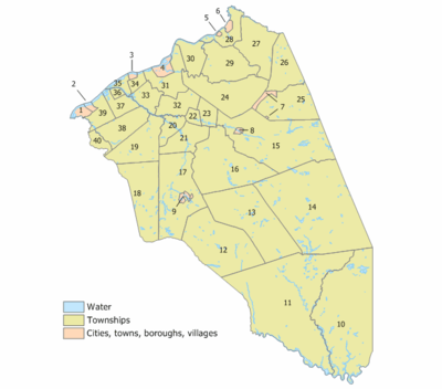
Municipalities in Burlington County (with 2010 Census data for population, housing units and area) are:[76]
| Municipality | Map key | Mun. type |
Pop. | Housing units |
Total area |
Water area |
Land area |
Pop. density |
Housing density |
School District | Communities[77] |
|---|---|---|---|---|---|---|---|---|---|---|---|
| Bass River Township | 10 | township | 1,443 | 587 | 78.27 | 3.22 | 75.04 | 19.2 | 7.8 | Pinelands (7-12) Bass River (PK-6) | Charcoal Landing Harrisville Leektown Martha Merrygold Munion Field New Gretna Wading River |
| Beverly | 3 | city | 2,577 | 1,086 | 0.78 | 0.23 | 0.55 | 4,645.4 | 1,957.7 | Palmyra (S/R) (9-12) Beverly (PK-8) | |
| Bordentown | 6 | city | 3,924 | 2,014 | 0.97 | 0.04 | 0.93 | 4,222.3 | 2,167.1 | Bordentown | |
| Bordentown Township | 28 | township | 11,367 | 4,360 | 9.33 | 0.82 | 8.51 | 1,335.0 | 512.1 | Bordentown | Bossert Estates Dunns Mill |
| Burlington | 4 | city | 9,920 | 4,223 | 3.78 | 0.72 | 3.06 | 3,239.1 | 1,378.9 | Burlington City | East Burlington |
| Burlington Township | 31 | township | 22,594 | 8,105 | 13.98 | 0.56 | 13.42 | 1,684.2 | 604.2 | Burlington Township | Deacons |
| Chesterfield Township | 27 | township | 7,699 | 1,601 | 21.52 | 0.19 | 21.33 | 360.9 | 75.0 | Northern Burlco (7-12) Chesterfield (PK-6) | Crosswicks Davisville |
| Cinnaminson Township | 39 | township | 15,569 | 5,758 | 8.06 | 0.56 | 7.50 | 2,074.5 | 767.2 | Cinnaminson | Bellview East Riverton |
| Delanco Township | 35 | township | 4,283 | 1,853 | 3.35 | 0.99 | 2.36 | 1,817.9 | 786.5 | Riverside (S/R) (9-12) Delanco (K-8) | |
| Delran Township | 37 | township | 16,896 | 6,442 | 7.21 | 0.62 | 6.59 | 2,563.4 | 977.4 | Delran | Bridgeboro Cambridge Fairview |
| Eastampton Township | 23 | township | 6,069 | 2,380 | 5.83 | 0.08 | 5.75 | 1,055.6 | 414.0 | Rancocas Valley (9-12) Eastampton (K-8) | |
| Edgewater Park | 34 | township | 8,881 | 3,926 | 3.04 | 0.15 | 2.89 | 3,068.8 | 1,356.6 | Burlington City (S/R) (9-12) Edgewater Park (PK-8) | Capitol Hill |
| Evesham Township | 18 | township | 45,538 | 18,303 | 29.71 | 0.42 | 29.28 | 1,555.1 | 625.0 | Lenape (9-12) Evesham (PK-8) | Cambridge Cropwell Crowfoot Donlontown Evans Corner Evesboro Marlboro Marlton CDP (10,133) Pine Grove |
| Fieldsboro | 5 | borough | 540 | 221 | 0.27 | 0.00 | 0.27 | 2,007.7 | 821.7 | Bordentown | |
| Florence Township | 30 | township | 12,109 | 5,053 | 10.18 | 0.40 | 9.78 | 1,238.1 | 516.6 | Florence | Bustleton Florence CDP (4,426) Roebling CDP (3,715) |
| Hainesport Township | 20 | township | 6,110 | 2,305 | 6.72 | 0.26 | 6.46 | 945.9 | 356.8 | Rancocas Valley (9-12) Hainesport (PK-8) | |
| Lumberton Township | 21 | township | 12,559 | 4,719 | 13.06 | 0.13 | 12.92 | 971.7 | 365.1 | Rancocas Valley (9-12) Lumberton (PK-8) | Eayrestown Fostertown |
| Mansfield Township | 29 | township | 8,544 | 3,529 | 21.91 | 0.17 | 21.74 | 393.0 | 162.3 | Northern Burlco (7-12) Mansfield (PK-6) | Columbus Georgetown Hedding Kinkora |
| Maple Shade Township | 40 | township | 19,131 | 9,186 | 3.82 | 0.00 | 3.82 | 5,006.1 | 2,403.7 | Maple Shade | |
| Medford | 17 | township | 23,033 | 8,652 | 39.93 | 1.01 | 38.92 | 591.8 | 222.3 | Lenape (9-12) Medford (PK-8) | Birchwood Lakes Braddocks Mill Chairville Christopher Mills Crossroads Fairview |
| Medford Lakes | 9 | borough | 4,146 | 1,543 | 1.29 | 0.13 | 1.16 | 3,569.5 | 1,328.4 | Lenape (9-12) Medford Lakes (PK-8) | |
| Moorestown Township | 38 | township | 20,726 | 7,862 | 14.92 | 0.23 | 14.69 | 1,410.6 | 535.1 | Moorestown | Bortons Landing Ivywood Moorestown-Lenola CDP (14,217) |
| Mount Holly | 22 | township | 9,536 | 3,861 | 2.85 | 0.05 | 2.81 | 3,397.9 | 1,375.8 | Rancocas Valley (9-12) Mount Holly (K-8) | Clermont |
| Mount Laurel | 19 | township | 41,864 | 18,249 | 21.97 | 0.28 | 21.69 | 1,930.0 | 841.3 | Lenape (9-12) Mount Laurel (PK-8) | Birchfield Bougher Centerton Colemantown Coxs Corner Fellowship Hartford Masonville Ramblewood CDP (5,907) Rancocas Woods |
| New Hanover Township | 25 | township | 7,385 | 613 | 22.40 | 0.22 | 22.18 | 333.0 | 27.6 | Bordentown (S/R) (9-12) New Hanover (PK-8) | Cookstown Fort Dix CDP (part; 5,951) McGuire Air Force Base CDP (part; 737) |
| North Hanover Township | 26 | township | 7,678 | 3,370 | 17.42 | 0.14 | 17.28 | 444.2 | 195.0 | Northern Burlco (7-12) North Hanover (PK-6) | Arneytown Ellisdale Jacobstown McGuire Air Force Base CDP (part; 2,973) |
| Palmyra | 1 | borough | 7,398 | 3,392 | 2.55 | 0.69 | 1.86 | 3,968.4 | 1,819.5 | Palmyra | |
| Pemberton | 8 | borough | 1,409 | 642 | 0.60 | 0.02 | 0.58 | 2,408.7 | 1,097.5 | Pemberton Township (S/R) | |
| Pemberton Township | 15 | township | 27,912 | 10,749 | 62.50 | 1.22 | 61.28 | 455.5 | 175.4 | Pemberton Township | Birmingham Browns Mills CDP (11,243) Browns Mills Junction Comical Corner Country Lake Estates CDP (3,943) Earlys Crossing Fort Dix CDP (part; 1,765) New Lisbon Ong's Hat Pemberton Heights CDP (2,423) Presidential Lakes Estates CDP (2,365) |
| Riverside Township | 36 | township | 8,079 | 3,147 | 1.61 | 0.12 | 1.49 | 5,425.9 | 2,113.5 | Riverside | |
| Riverton | 2 | borough | 2,779 | 1,112 | 0.97 | 0.30 | 0.66 | 4,179.4 | 1,672.3 | Palmyra (S/R) (9-12) Riverton (K-8) | |
| Shamong Township | 12 | township | 6,490 | 2,227 | 44.99 | 0.60 | 44.39 | 146.2 | 50.2 | Lenape (9-12) Shamong (K-8) | Atsion Dellette High Crossing |
| Southampton Township | 16 | township | 10,464 | 5,024 | 44.22 | 0.56 | 43.67 | 239.6 | 115.1 | Lenape (9-12) Southampton (K-8) | Beaverville Buddtown Burrs Mill Chairville Crescent Heights Ewansville Leisuretowne CDP (3,282) Retreat Sandtown Vincentown |
| Springfield Township | 24 | township | 3,414 | 1,217 | 30.00 | 0.06 | 29.94 | 114.0 | 40.6 | Northern Burlco (7-12) Springfield (K-6) | Arneys Mount Chambers Corner Fort Dix CDP (part) Jacksonville Juilustown CDP (429) Jobstown |
| Tabernacle Township | 13 | township | 6,949 | 2,445 | 49.61 | 0.49 | 49.12 | 141.5 | 49.8 | Lenape (9-12) Tabernacle (PK-8) | Bozuretown Eagle Speedwell |
| Washington Township | 11 | township | 687 | 284 | 102.71 | 3.18 | 99.52 | 6.9 | 2.9 | Greater Egg Harbor (S/R) (9-12) Washington (PK-8) | Batsto Bulltown Crowleytown Green Bank |
| Westampton Township | 32 | township | 8,813 | 3,291 | 11.19 | 0.17 | 11.03 | 799.4 | 298.5 | Rancocas Valley (9-12) Westampton (K-8) | Rancocas Timbuctoo |
| Willingboro Township | 33 | township | 31,629 | 11,442 | 8.15 | 0.41 | 7.74 | 4,087.3 | 1,478.6 | Willingboro | Bortons Landing Buckingham Park Charleston Cooperstown Country Club Ridge |
| Woodland Township | 14 | township | 1,788 | 494 | 96.39 | 1.83 | 94.56 | 18.9 | 5.2 | Lenape (9-12) Woodland (PK-8) | Bullock Butlers Place Chatsworth Dukes Bridge Johnson Place Jones Mill Woodmansie |
| Wrightstown | 7 | borough | 802 | 348 | 1.77 | 0.00 | 1.77 | 453.6 | 196.8 | Bordentown (S/R) (9-12) New Hanover (PK-8) | |
| Burlington County | county | 448,734 | 175,615 | 819.84 | 21.26 | 798.58 | 561.9 | 219.9 |
Most municipalities have their own municipal courts, which handle traffic and minor criminal and civil matters,. The New Jersey Superior Court handles more serious cases.
Education
Rowan College at Burlington County is a two-year public community college serving students from Burlington County. The school, located at campuses in Pemberton and Mount Laurel and was founded in 1966 and opened to students in 1969.[78]
Libraries
The Burlington County Library became the first county library in New Jersey when it was established in 1921 in Mount Holly. Library service grew in popularity and several moves ensued as more space became a necessity. By 1971, a new headquarters facility had been constructed, Cinnaminson Township and Bordentown had joined the system as branches, and a bookmobile visited areas without local facilities. Medford and Evesham Township had joined the system by 1975. The Pemberton Township Branch joined the system in 1987. Maple Shade Township became a branch in April 2001 while Riverton, the newest branch, joined in December 2003. With a larger network of nine additional member libraries, the system provides a range of services to its residents.[79]
Transportation
Roads and highways
As of May 2010, the county had a total of 2,609.74 miles (4,199.97 km) of roadways, of which 1,913.83 miles (3,080.01 km) were maintained by the local municipality, 504.18 miles (811.40 km) by Burlington County, 154.01 miles (247.86 km) by the New Jersey Department of Transportation and 37.72 miles (60.70 km) by the New Jersey Turnpike Authority.[80]
A variety of major routes were constructed through Burlington County. Major county roads include County Route 528, County Route 530, County Route 532, County Route 534 (only in Shamong Township), County Route 537, County Route 541, County Route 542, County Route 543, County Route 544, County Route 545 and County Route 563. State Routes that pass through are Route 38, Route 68, Route 70, Route 72, Route 73, Route 90 (only in Cinnaminson Township), and Route 413 (only in Burlington). U.S. Routes that traverse are U.S. Route 9 (only in Bass River Township), U.S. Route 130 and U.S. Route 206. Limited access roads include the Garden State Parkway (a 7.4 miles (11.9 km) stretch in Bass River Township[81]), Interstate 295 and the New Jersey Turnpike (a portion of Interstate 95).
The Turnpike extends through the county for approximately 30.1 miles (48.4 km) from Cherry Hill in Camden County to Hamilton Township in Mercer County (including the 6.5 mile (10.5 km) Turnpike Extension from the turnpike bridge over the Delaware River to the mainline at Exit 6).[82][83]
The county has five Turnpike exchanges: Exit 4 in Mount Laurel, Exit 5 in Westampton Township, Exit 6A in Florence Township, Exit 6 in Mansfield Township and Exit 7 in Bordentown Township.[84]
The New Jersey Turnpike Authority plans to widen the Parkway to three lanes in each direction from exit 80 in South Toms River, Ocean County to exit 30 in Somers Point, Atlantic County, including widening of bridges at several river crossings.[85] The Authority extended the 'dual-dual' configuration (inner car lanes and outer car / truck / bus lanes) south to Exit 6 from its former end at Exit 8A in Monroe Township, Middlesex County. This was finished in early November 2014.[86][87]
Bridges
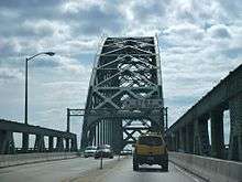
The Burlington County Bridge Commission maintains the Tacony–Palmyra Bridge and the Burlington–Bristol Bridge, both of which cross the Delaware River. The agency also maintains several bridges along CR 543, including the Riverside–Delanco Bridge over the Rancocas Creek.[88]
The Tacony–Palmyra Bridge is a combination steel tied arch and double-leaf bascule bridge across the Delaware River that connects New Jersey Route 73 in Palmyra with Pennsylvania Route 73 in the Tacony section of Philadelphia. Designed by architect Ralph Modjeski, the bridge is 3,659 feet (1,115 m) long and spans 2,324 feet (708 m). After 18 months of construction, the bridge opened in 1929, replacing ferry service that had operated between the two places since 1922.[89]
The Burlington–Bristol Bridge is a truss bridge with a lift span crossing the Delaware River from Burlington to Bristol Township, Pennsylvania. Construction of the bridge started on April 1, 1930, and the bridge opened to traffic on May 2, 1931. The two-lane bridge is 2,301 feet (701 m) long; The lift span is 540 feet (164.6 m) long.[90]
The 13.5 million toll-paying trips on the Burlington–Bristol and Tacony–Palmyra bridges and the per-car toll of $4 (reduced to $3 with E-ZPass) for cars heading into Pennsylvania generated $51 million in revenue in 2016.[91]
The Riverside–Delanco Bridge is a truss bridge with a central swing span that carries County Route 543 across the Rancocas Creek, between Riverside Township and Delanco Township. The current bridge was built in 1934–1935 to replace the 1901 bridge, which itself replaced an 1870 structure.[92]
Public transportation
The River Line is a diesel light-rail system operated for NJ Transit by the Southern New Jersey Rail Group on a former Pennsylvania Railroad line between the Trenton Transit Center in Trenton and the Walter Rand Transportation Center and other stations in Camden, with 11 stations in the county.[93]
NJ Transit operates bus service into Philadelphia on the following routes; 317, 406, 409 414, and 417 routes, and into Camden only on the following routes; 407, 413, 418, 419 and 457; and to Atlantic City on the 559 route.[94][95]
Academy Bus Lines operates buses from Mount Holly, Mount Laurel, Westampton Township and Willingboro Township to New York City's Port Authority Bus Terminal in Midtown Manhattan as well as the Wall Street area of Lower Manhattan.[96]
The BurLink bus service provides three routes, under service funded by the county and operated by Stout's Transportation, providing connections to NJ Transit's bus and rail service.[97]
Wineries
- DeMastro Vineyards (Southampton Township)
- Iron Plow Vineyards (in the Columbus section of Mansfield Township)
- Valenzano Winery (Shamong Township)
See also
References
- New Jersey County Map, New Jersey Department of State. Accessed July 10, 2017.
- QuickFacts for Burlington County, New Jersey from Population estimates, July 1, 2018, (V2018), United States Census Bureau. Accessed July 1, 2019.
- QuickFacts - Burlington County, New Jersey; New Jersey; United States, United States Census Bureau. Accessed March 24, 2018.
- Annual Estimates of the Resident Population: April 1, 2010 to July 1, 2017 - 2017 Population Estimates Archived February 13, 2020, at Archive.today, United States Census Bureau. Accessed March 24, 2018.
- GCT-PEPANNCHG: Estimates of Resident Population Change and Rankings: July 1, 2016 to July 1, 2017 - State -- County / County Equivalent from the 2017 Population Estimates for New Jersey Archived February 13, 2020, at Archive.today, United States Census Bureau. Accessed March 24, 2018.
- DP1 - Profile of General Population and Housing Characteristics: 2010 Demographic Profile Data for Burlington County, New Jersey, United States Census Bureau. Accessed January 21, 2013.
- NJ Labor Market Views Archived 2013-09-20 at the Wayback Machine, New Jersey Department of Labor and Workforce Development, March 15, 2011. Accessed October 3, 2013.
- New Jersey: 2010 - Population and Housing Unit Counts; 2010 Census of Population and Housing, p. 6, CPH-2-32. United States Census Bureau, August 2012. Accessed August 29, 2016.
- Snyder, John P. The Story of New Jersey's Civil Boundaries: 1606-1968, Bureau of Geology and Topography; Trenton, New Jersey; 1969. p. 93. Accessed September 30, 2013.
- Map and history of How New Jersey's counties were created, New Jersey Genealogy Solutions. Accessed October 9, 2013.
- Hutchinson, Viola L. The Origin of New Jersey Place Names, New Jersey Public Library Commission, May 1945. Accessed August 28, 2015.
- Gannett, Henry. The Origin of Certain Place Names in the United States, p. 61. United States Government Printing Office, 1905. Accessed August 28, 2015.
- Heavens, Alan J. "Town By Town: Mount Holly keeps people coming back", The Philadelphia Inquirer, July 21, 2013. Accessed September 30, 2013. "Mount Holly, is, of course, the Burlington County seat. It has been since 1793, and many historic buildings lining the streets near the county offices are occupied by law firms, bail-bond providers, and title companies."
- Census 2010 U.S. Gazetteer Files: New Jersey Counties, United States Census Bureau. Accessed May 11, 2015.
- New Jersey County High Points, Peakbagger.com. Accessed October 3, 2013.
- Areas touching Burlington County, MapIt. Accessed December 29, 2014.
- Monthly Averages for Mount Holly, New Jersey, The Weather Channel. Accessed October 13, 2012.
- "NOWData". NOAA. Retrieved May 11, 2016.
- "1981-2010 Normals". NOAA. Retrieved May 11, 2016.
- Forstall, Richard L. Population of states and counties of the United States: 1790 to 1990 from the Twenty-one Decennial Censuses, pp. 108-109. United States Census Bureau, March 1996. ISBN 9780934213486. Accessed October 3, 2013.
- DP-1 - Profile of General Demographic Characteristics: 2000; Census 2000 Summary File 1 (SF 1) 100-Percent Data for Burlington County, New Jersey, United States Census Bureau. Accessed January 21, 2013.
- U.S. Census website , United States Census Bureau. Accessed September 4, 2014.
- Tables DP-1 to DP-4 from Census 2000 for Somerset County, New Jersey, United States Census Bureau, backed up by the Internet Archive as of July 6, 2008. Accessed October 3, 2013.
- DP-2 - Profile of Selected Social Characteristics: 2000 from the Census 2000 Summary File 3 (SF 3) - Sample Data for Burlington County, New Jersey, United States Census Bureau. Accessed September 30, 2013.
- DP-3 - Profile of Selected Economic Characteristics: 2000 from Census 2000 Summary File 3 (SF 3) - Sample Data for Burlington County, New Jersey, United States Census Bureau. Accessed September 30, 2013.
- Local Area Gross Domestic Product, 2018, Bureau of Economic Analysis, released December 12, 2019. Accessed December 12, 2019.
- 250 Highest Per Capita Personal Incomes available for 3113 counties in the United States: 2015 Archived 2017-10-26 at the Wayback Machine, New Jersey Department of Labor and Workforce Development. Accessed October 24, 2017.
- Local Area Personal Income: 2015 Archived 2017-10-15 at the Wayback Machine, Bureau of Economic Analysis. Accessed October 24, 2017.
- 250 Highest Per Capita Personal Incomes of the 3113 Counties in the United States, 2009, Bureau of Economic Analysis, backed up by the Internet Archive as of December 12, 2011. Accessed November 25, 2015.
- Board of Chosen Freeholders, Burlington County, New Jersey. Accessed November 9, 2019.
- Gallo Jr., Bill. "Which N.J. county freeholders are paid the most?", NJ.com, March 11, 2016. Accessed October 25, 2017. "Freeholder director: $11,053; Other freeholders: $10,553"
- 2019 Board of Chosen Freeholders, Burlington County, New Jersey. Accessed January 11, 2020.
- Tom Pullion, Burlington County, New Jersey. Accessed November 9, 2019.
- Balvir Singh, Burlington County, New Jersey. Accessed November 9, 2019.
- Felicia Hopson, Burlington County, New Jersey. Accessed November 9, 2019.
- Daniel J. O’Connell, Burlington County, New Jersey. Accessed November 9, 2019.
- Linda A. Hynes, Burlington County, New Jersey. Accessed January 11, 2020.
- New Jersey State Constitution (1947), Article VII, Section II, Paragraph 2, New Jersey Department of State. Accessed October 26, 2017.
- Surrogate, Burlington County. Accessed November 9, 2019.
- Members List: Surrogates, Constitutional Officers Association of New Jersey. Accessed November 9, 2019.
- Sheriff's Department, Burlington County. Accessed November 9, 2019.
- Members List: Sheriffs, Constitutional Officers Association of New Jersey. Accessed November 9, 2019.
- County Clerk Department, Burlington County. Accessed November 9, 2019.
- Members List: Clerks, Constitutional Officers Association of New Jersey. Accessed November 9, 2019.
- Scott A. Coffina, Burlington County, New Jersey. Accessed November 9, 2019. "Scott A. Coffina was sworn in as the Burlington County Prosecutor on March 31, 2017."
- "Governor Chris Christie Files Nominations and Direct Appointments", Governor of New Jersey Chris Christie press release dated February 27, 2017. Accessed October 25, 2017. "Burlington County Prosecutor - Nominate for appointment the Honorable Scott A. Coffina (Marlton, Burlington)"
- Burlington County, New Jersey Courts. Accessed October 22, 2017.
- 2012 Congressional Districts by County, New Jersey Department of State Division of Elections. Accessed October 3, 2013.
- Plan Components Report, New Jersey Department of State Division of Elections, December 23, 2011. Accessed October 3, 2013.
- Directory of Representatives: New Jersey, United States House of Representatives. Accessed January 3, 2019.
- Full Biography, Congressman Donald Norcross. Accessed January 3, 2019. "Donald and his wife Andrea live in Camden City and are the proud parents of three grown children and grandparents of two."
- Directory of Representatives: New Jersey, United States House of Representatives. Accessed January 3, 2019.
- Directory of Representatives: New Jersey, United States House of Representatives. Accessed January 3, 2019.
- 2011 Legislative Districts by County, New Jersey Department of State Division of Elections. Accessed October 3, 2013.
- Colimore, Edward. "Traffic changes eyed for area of joint base", The Philadelphia Inquirer, September 3, 2011. Accessed November 2, 2013. "More than 22,000 people work at the joint base, which is surrounded by Wrightstown, New Hanover, North Hanover, Pemberton Borough, Pemberton Township, and Springfield Township in Burlington County, and Lakehurst Borough and Manchester, Jackson, and Plumsted Townships in Ocean County."
- Zimmaro, Mark. "Military bases set for merger", Burlington County Times, August 28, 2009. Accessed November 2, 2013. "The 42000-acre facility will be called Joint Base McGuire-Dix-Lakehurst.... The pay discrepancies are because Fort Dix and McGuire are primarily in Burlington County, where salaries are based on Philadelphia wages."
- Leip, David. "Dave Leip's Atlas of U.S. Presidential Elections". uselectionatlas.org. Retrieved 2018-06-09.
- Statewide Voter Registration Summary New Jersey Department of State Division of Elections, as of December 31, 2019. Accessed January 3, 2020.
- GCT-P7: Selected Age Groups: 2010 - State -- County / County Equivalent from the 2010 Census Summary File 1 for New Jersey, United States Census Bureau. Accessed May 11, 2015.
- Presidential November 6, 2012 General Election Results - Burlington County Archived December 26, 2014, at the Wayback Machine, New Jersey Department of State Division of Elections, March 15, 2013. Accessed December 29, 2014.
- Number of Registered Voters and Ballots Cast November 6, 2012 General Election Results - Burlington County Archived December 26, 2014, at the Wayback Machine, New Jersey Department of State Division of Elections, March 15, 2013. Accessed December 29, 2014.
- 2008 Presidential General Election Results: Burlington County, New Jersey Department of State Division of Elections, December 23, 2008. Accessed December 29, 2014.
- 2004 Presidential Election: Burlington County, New Jersey Department of State Division of Elections, December 13, 2004. Accessed December 29, 2014.
- 2013 Governor: Burlington County, New Jersey Department of State Division of Elections, January 29, 2014. Accessed December 29, 2014.
- Number of Registered Voters and Ballots Cast November 5, 2013 General Election Results : Burlington County, New Jersey Department of State Division of Elections, January 29, 2014. Accessed December 29, 2014.
- 2009 Governor: Burlington County Archived 2016-01-13 at the Wayback Machine, New Jersey Department of State Division of Elections, December 31, 2009. Accessed December 29, 2014.
- Levinsky, Dave. "Republicans outspent Democrats 6 to 1 in losing freeholder campaign", Burlington County Times, December 13, 2012. Accessed September 30, 2013. "Released earlier this month by the New Jersey Election Law Enforcement Commission, the campaign finance reports showed Freeholders Bruce Garganio and Mary Ann O'Brien spent a total of $642,778 in their losing effort, including $85,000 on television advertising during the last two weeks before the election.... By contrast, Democratic Freeholders-elect Aimee Belgard and Joanne Schwartz spent a combined $82,707, none on TV commercials."
- Sharnak, Debbie. "Republican Tom MacArthur Wins NJ's Most Competitive Congressional Race — By Double Digits", IVN, November 5, 2014. Accessed May 11, 2015.
- Official List Candidates for House of Representatives For GENERAL ELECTION 11/04/2014 Election, New Jersey Department of State Division of Elections, December 2, 2014. Accessed May 11, 2015.
- Scala, Kristina. "Republicans Peters, Gibbs oust Democrats; win Burlington County freeholders race", Burlington County Times, November 3, 2015. Accessed March 27, 2016. "Republican newcomers Ryan Peters and Kate Gibbs unseated incumbent Democrats Aimee Belgard and Joanne Schwartz in the Burlington County freeholders race. The 3-2 GOP majority will now transform into a full five-seat stronghold on the board."
- Krebs, Rose. "Democrats declare upset in county freeholder race; Republicans will not concede", Burlington County Times, November 8, 2017. Accessed December 2, 2017.
- Levinsky, David. "Burlington County Democrats gain ground with election wins", Burlington County Times, November 8, 2017. Accessed December 2, 2017.
- “Democrats win control of Burlington County Board of Freeholders”, Burlington County Times, November 6, 2018. Accessed November 7, 2019.
- Comengo, Carol. "George Youngkin resigns as Burlington County freeholder after one day in office". The Courier-Post. USA Today Network. Retrieved 17 June 2020.
- “Democrats declare victory in Burlington County freeholder, sheriff races”, Burlington County Times, November 5, 2019. Accessed November 7, 2019.
- GCT-PH1: Population, Housing Units, Area, and Density: 2010 - County -- County Subdivision and Place from the 2010 Census Summary File 1 for Burlington County, New Jersey, United States Census Bureau. Accessed May 11, 2015.
- Locality Search, State of New Jersey. Accessed May 11, 2015.
- College History, Rowan College at Burlington County. Accessed November 10, 2016.
- About the Library, Burlington County Library. Accessed October 9, 2013.
- Burlington County Mileage by Municipality and Jurisdiction, New Jersey Department of Transportation, May 2010. Accessed November 21, 2013.
- Garden State Parkway, New Jersey Department of Transportation, January 1997. Accessed November 21, 2013.
- Interstate 95 / New Jersey Turnpike Straight Line Diagram, New Jersey Department of Transportation, October 2001. Accessed November 21, 2013.
- New Jersey Turnpike Straight Line Diagram, New Jersey Department of Transportation, January 1997. Accessed June 16, 2014.
- Travel Resources: Interchanges, Service Areas & Commuter Lots, New Jersey Turnpike Authority. Accessed October 3, 2013.
- Garden State Parkway Milepost 30 to 80 Widening Project, New Jersey Turnpike Authority. Accessed October 3, 2013.
- Widening Program Overview, New Jersey Turnpike Authority. Accessed October 3, 2013. "The NJ Turnpike Interchange 6 to 9 Widening Program (Widening Program) consists of approximately 35 miles of road widening and associated interchange improvements from the vicinity of Interchange 6, in Mansfield Township, Burlington County (Milepost 48) to just south of Interchange 9 in East Brunswick Township, Middlesex County (Milepost 83). The proposed improvements to the Turnpike include: Widening the mainline from 6-lanes to 12-lanes from a point approximately 2 miles south of Interchange 6 to the existing 10-lane dual-dual roadway south of Interchange 8A."
- Gov. Christie, NJDOT Commissioner Fox Praise $2.3 Billion NJ Turnpike Infrastructure Investment Project Archived November 3, 2014, at the Wayback Machine, New Jersey Turnpike Authority. Accessed November 3, 2014. "The Widening Program created a three-lane Outer Roadway in each direction over the 25 miles between Interchange 6 in Mansfield Township, Burlington County, and Interchange 8A in Monroe Township, Middlesex County."
- About Our Bridges Archived 2014-07-15 at the Wayback Machine, Burlington County Bridge Commission. Accessed November 1, 2017.
- Tacony–Palmyra Bridge Archived 2013-04-14 at Archive.today, Burlington County Bridge Commission. Accessed November 1, 2017.
- Burlington-Bristol Bridge Archived 2011-05-05 at the Wayback Machine, Burlington County Bridge Commission. Accessed November 1, 2017.
- Hoover, Amanda. "Here's how much Delaware River bridges collected in tolls last year", NJ.com, October 23, 2017. Accessed November 1, 2017. "The two smallest, and cheapest bridges, connect Burlington County to Northeast Philadelphia and Bristol, Pennsylvania. Operated by the Burlington County Bridge Commission, the Palmyra-Tacony and Burlington-Bristol bridges charge $3 for EZ-Pass users and $4 in cash, bringing in a combined revenue of $51,195,356.70 in 2016. Together, the two bridges brought nearly 13.5 million vehicles from New Jersey into Pennsylvania."
- Riverside-Delanco Bridge Archived 2017-11-07 at the Wayback Machine, Burlington County Bridge Commission. Accessed November 1, 2017.
- River LINE System Map, NJ Transit. Accessed November 21, 2013.
- Burlington County Bus / Rail Connections, NJ Transit, backed up by the Internet Archive as of May 22, 2009. Accessed September 22, 2014.
- South Jersey Transit Guide Archived 2018-09-29 at the Wayback Machine, Cross County Connection, as of April 1, 2010. Accessed September 22, 2014.
- General Information, Academy Bus. Accessed September 22, 2014.
- BurLink Bus Service Archived 2013-10-04 at the Wayback Machine, Burlington County, New Jersey. Accessed October 3, 2013.
External links
| Wikimedia Commons has media related to Burlington County, New Jersey. |
- Official website

- Burlington County Chamber of Commerce

- Sheriffs of Burlington County, New Jersey
Places adjacent to Burlington County, New Jersey | ||||||||||
|---|---|---|---|---|---|---|---|---|---|---|
| ||||||||||

| Counties |  | |
|---|---|---|
| Major cities | ||
| Cities and towns 50k-99k | ||
| Cities and towns 30k-50k | ||
| Authority control |
|
|---|