Yakutat, Alaska
The City and Borough of Yakutat[1] (/ˈjækətæt/, YAK-ə-tat)[5] (Tlingit: Yaakwdáat; Russian: Якутат) is a borough[6] in the U.S. state of Alaska and was the name of a former city within it. The name is Tlingit, Yaakwdáat ("the place where canoes rest") but it originally derives from an Eyak name diyaʼqudaʼt and was influenced by the Tlingit word yaakw ("canoe, boat"). The borough covers an area about six times the size of the U.S. state of Rhode Island, making it one of the largest counties (or county equivalents) in the United States. As of the 2010 census, the population was 662, making it the ninth-least populous county nationwide[7][8][9] down from 680 in 2000.
City and Borough of Yakutat[1] | |
|---|---|
Home Rule Borough | |
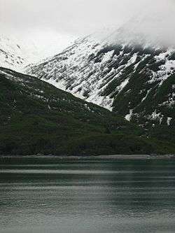 Yakutat Bay | |
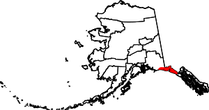 Map of Alaska highlighting Yakutat City and Borough | |
| Coordinates: 59°32′49″N 139°43′38″W[2] | |
| Country | United States |
| State | Alaska |
| Borough seat[1] | Yakutat |
| Government | |
| • Mayor | Ralph Wolfe |
| Area | |
| • Borough | 9,463 sq mi (24,509 km2) |
| • Land | 7,649 sq mi (19,812 km2) |
| • Water | 1,813 sq mi (4,697 km2) |
| • Urban | 104.1 sq mi (269.6 km2) |
| • Land (CDP) | 100.5 sq mi (260.3 km2) |
| • Water (CDP) | 3.6 sq mi (9.3 km2) |
| Elevation | 69 ft (21 m) |
| Population (2010) | |
| • Borough | 662 |
| • Estimate (2019)[4] | 579 |
| • Density | 0.070/sq mi (0.027/km2) |
| • Urban (CDP)[3] | 662 |
| • Urban density | 6.4/sq mi (2.5/km2) |
| Time zone | UTC-9 (Alaska (AKST)) |
| FIPS code | 02-282 (borough), 02-86490 (CDP) |
| GNIS feature ID | 1415858, 1419986 |
| Website | yakutatak |
The Borough of Yakutat was incorporated as a non-unified Home Rule Borough[5] on September 22, 1992. Yakutat was previously a city in the Skagway–Yakutat–Angoon Census Area (afterwards renamed the Skagway–Hoonah–Angoon Census Area).[10]
The U.S. Census Bureau has defined the former City of Yakutat as a census-designated place within the borough.[11] The only other significant population center in the borough is the community of Icy Bay, the site of the Icy Bay Airport, in the west-central part of the borough.
History
The original settlers in the Yakutat area are believed to have been Eyak-speaking people from the Copper River area. Tlingits migrated into the area and assimilated the Eyaks before the arrival of Europeans in Alaska. Yakutat was only one of a number of Tlingit and mixed Tlingit-Eyak settlements in the region, although all the others have been depopulated or abandoned.
In the eighteenth and nineteenth centuries, English, French, Spanish and Russian explorers came to the region. The Shelikhov-Golikov Company, precursor of the Russian-American Company, built a fort in Yakutat in 1795 to facilitate trade in sea otter pelts. It was known as New Russia, Yakutat Colony, or Slavorossiya.[12] When the Russians cut off access to the fisheries nearby, a Tlingit war party attacked and destroyed the fort.
By 1886, after the Alaska Purchase by the United States, the black sand beaches in the area were being mined for gold. In 1889 the Swedish Free Mission Church opened a school and sawmill in the area.
A cannery, another sawmill, a store and a railroad were constructed from 1903 by the Stimson Lumber Company. Many people moved to the current site of Yakutat to be closer to the Stimson cannery, which operated through 1970. During World War II, the USAAF stationed a large aviation garrison near Yakutat and built a paved runway. The troops were withdrawn after the war but the runway is still in use as Yakutat Airport, which offers scheduled airline service.
Fishing is currently the largest economic activity in Yakutat.
Yakutat Tlingit Tribe (YTT) received a Language Preservation Grant from the Administration for Native Americans in 2004. With this, they have reinvigorated their efforts to teach the Tlingit language to middle-aged and young people. YTT received another ANA grant in 2007 and is expanding its role in the schools. All the YTT Tlingit language revitalization work focuses on using communicative approaches to second language teaching, such as TPR and ASLA.
While working at a local cannery from 1912 to 1941, Seiki Kayamori extensively photographed Yakutat and its area. A large set of prints of his work is held by Yakutat City Hall.[13]
.jpeg)
Yakutat and Southern Railway was a rail operation in the area.
Geography
According to the U.S. Census Bureau, the borough has a total area of 9,463 square miles (24,510 km2), of which 7,649 square miles (19,810 km2) is land and 1,813 square miles (4,700 km2) is water.[14] The 2010 census also defines a smaller census-designated place named Yakutat which has a total area of 104.1 square miles (269.6 km2), of which 100.5 square miles (260.3 km2) is land and 3.6 square miles (9.3 km2) is water.[3]
Yakutat's population center is located at 59°32′49″N 139°43′38″W, at the mouth of Yakutat Bay. It lies in an isolated location in lowlands along the Gulf of Alaska, 212 miles (341 kilometres)) northwest of Juneau.
Yakutat borders the Gulf of Alaska to the west, Valdez-Cordova Census Area, Alaska to the northwest, Hoonah-Angoon Census Area, Alaska to the southeast, Stikine Region, British Columbia to the northeast-east and Yukon Territory to the north.
The borough contains part of the protected areas of Chugach National Forest, Glacier Bay National Park, Glacier Bay Wilderness, Tongass National Forest, Wrangell-St. Elias National Park and Preserve, Wrangell-Saint Elias Wilderness and the Russell Fjord Wilderness.
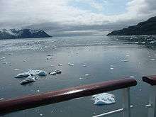
One unique feature in the Borough is Hubbard Glacier, North America's largest tidewater glacier. In 1986 and 2002, the glacier blocked the entrance to Russell Fiord. The resulting Russell Lake rose 83 feet (25.30 m) and 61 feet (18.59 m) until the glacial dam failed. If Russell Lake rises to 135 feet (41.15 m), the water will spill over a pass and flow into the Situk River. This will have a major impact on a world-class fishery. Yakutat will not be impacted unless the glacier advances to the townsite, which could take a thousand years. The vegetation in the area indicates that water was flowing over the pass until about 1860.
Climate
Yakutat has a subarctic climate (Dfc) but with characteristics such as high precipitation, absence of frozen soil and temperate rainforest vegetation of the subpolar oceanic climate zone of the Pacific Coast. It rivals Ketchikan as the wettest "city" in the United States, with an annual precipitation (1981−2010 normals) of 155 inches (3.94 m), which falls on 240 days of the year, including 150 inches (381 cm) of snow, almost all of it falling from November through April, that occurs on 64 days annually. (However, with an annual precipitation of 197.8 inches (5.02 m), the city of Whittier receives significantly more annual precipitation than both Yakutat and Ketchikan, which makes it the wettest city in Alaska and the United States, and Yakutat and Ketchikan the second- and third-wettest cities in Alaska, respectively.[15]) September and October represent, on average, the year's primary "rainy season," with an average of over 20 inches of precipitation both months. On average, the year's driest period is late April through July, though no month qualifies as a true "dry season." The monthly daily average temperature ranges from 28.1 °F (−2.2 °C) in January to 54.4 °F (12.4 °C) in July. Extreme temperatures have ranged from −24 °F (−31 °C) on December 30, 1964 up to 88 °F (31 °C) on August 15, 2004, though there are typically 4.9 days of sub-0 °F (−18 °C) lows and only 4 days of 70 °F (21 °C)+ highs annually.[16] Unlike in South Central Alaska, a day with a high temperature under 0 °F (−18 °C) has never been recorded.[17][18]
| Climate data for Yakutat, Alaska (Yakutat State Airport), 1981−2010 normals, extremes 1917−present | |||||||||||||
|---|---|---|---|---|---|---|---|---|---|---|---|---|---|
| Month | Jan | Feb | Mar | Apr | May | Jun | Jul | Aug | Sep | Oct | Nov | Dec | Year |
| Record high °F (°C) | 58 (14) |
56 (13) |
59 (15) |
71 (22) |
80 (27) |
87 (31) |
85 (29) |
88 (31) |
77 (25) |
63 (17) |
59 (15) |
55 (13) |
88 (31) |
| Average high °F (°C) | 33.7 (0.9) |
36.3 (2.4) |
39.5 (4.2) |
45.7 (7.6) |
52.3 (11.3) |
57.3 (14.1) |
60.1 (15.6) |
60.6 (15.9) |
55.7 (13.2) |
47.4 (8.6) |
38.5 (3.6) |
35.1 (1.7) |
46.9 (8.3) |
| Daily mean °F (°C) | 28.1 (−2.2) |
29.7 (−1.3) |
32.0 (0.0) |
37.8 (3.2) |
44.7 (7.1) |
50.8 (10.4) |
54.3 (12.4) |
53.8 (12.1) |
48.4 (9.1) |
41.0 (5.0) |
32.3 (0.2) |
29.6 (−1.3) |
40.2 (4.6) |
| Average low °F (°C) | 22.4 (−5.3) |
23.0 (−5.0) |
24.6 (−4.1) |
30.0 (−1.1) |
37.2 (2.9) |
44.4 (6.9) |
48.7 (9.3) |
47.3 (8.5) |
41.4 (5.2) |
34.8 (1.6) |
26.3 (−3.2) |
24.4 (−4.2) |
33.7 (0.9) |
| Record low °F (°C) | −22 (−30) |
−20 (−29) |
−20 (−29) |
3 (−16) |
9 (−13) |
29 (−2) |
35 (2) |
29 (−2) |
16 (−9) |
6 (−14) |
−10 (−23) |
−24 (−31) |
−24 (−31) |
| Average precipitation inches (mm) | 13.66 (347) |
10.86 (276) |
10.98 (279) |
9.19 (233) |
8.21 (209) |
6.39 (162) |
7.88 (200) |
14.15 (359) |
21.11 (536) |
22.01 (559) |
14.46 (367) |
16.28 (414) |
155.18 (3,941) |
| Average snowfall inches (cm) | 31.3 (80) |
28.2 (72) |
28.5 (72) |
11.0 (28) |
0.5 (1.3) |
0 (0) |
0 (0) |
0 (0) |
0 (0) |
3.2 (8.1) |
20.4 (52) |
27.4 (70) |
150.4 (382) |
| Average precipitation days (≥ 0.01 inch) | 21.9 | 18.6 | 19.3 | 18.5 | 17.5 | 17.0 | 18.5 | 18.9 | 21.7 | 24.0 | 21.6 | 22.5 | 240 |
| Average snowy days (≥ 0.1 in) | 12.0 | 11.0 | 11.6 | 6.1 | 0.3 | 0 | 0 | 0 | 0 | 1.7 | 8.7 | 12.6 | 64 |
| Average relative humidity (%) | 82.8 | 83.1 | 81.2 | 81.4 | 82.5 | 84.5 | 87.7 | 88.5 | 89 | 87.6 | 84.8 | 84.1 | 84.8 |
| Source: NOAA[17][19] | |||||||||||||
Demographics
| Historical population | |||
|---|---|---|---|
| Census | Pop. | %± | |
| 1880 | 300 | — | |
| 1890 | 308 | 2.7% | |
| 1900 | 247 | −19.8% | |
| 1910 | 271 | 9.7% | |
| 1920 | 165 | −39.1% | |
| 1930 | 265 | 60.6% | |
| 1940 | 292 | 10.2% | |
| 1950 | 298 | 2.1% | |
| 1960 | 230 | −22.8% | |
| 1970 | 190 | −17.4% | |
| 1980 | 449 | 136.3% | |
| 1990 | 534 | 18.9% | |
| 2000 | 680 | 27.3% | |
| 2010 | 662 | −2.6% | |
| Est. 2019 | 579 | [4] | −12.5% |
| U.S. Decennial Census[20] 1990-2000[21] 2010-2018[7] | |||
Yakutat first appeared on the 1880 U.S. Census as an unincorporated Tlingit-Yakutat village. All 300 residents were listed as Tlingit.[22] In 1890, it reported 308 residents, and this included the populations of the native villages at Dry Bay & Lituya (Bay). 300 were listed as Native, 7 Whites and 1 Creole (Mixed Russian & Native).[23] It continued to report on every successive census. In 1948, Yakutat formally incorporated. In 1992, it broke away from the Skagway-Yakutat-Angoon Census Area to form its own borough of Yakutat. It disincorporated at its formation and became a census-designated place (CDP).
2010 Census
At the 2010 census,[8][9] there were 662 people, 502 households, and 201 families residing in the Yakutat. The racial makeup was 50.37% White, 0.12% Black or African American, 39.60% Native American, 1.24% Asian, 0.74% Pacific Islander, and 7.92% from two or more races. Hispanic or Latino of any race were 0.74% of the population.
5.78% reported speaking Tlingit at home.[24]
Of the 265 households, 32.8% had children under the age of 18 living with them, 38.5% were married couples living together, 12.1% had a female householder with no husband present, and 40.0% were non-families. 32.1% of households were one person, and 4.9% were one person aged 65 or older. The average household size was 2.59 and the average family size was 3.30.
The population was spread out, with 28.1% under the age of 18, 5.3% from 18 to 24, 32.5% from 25 to 44, 28.7% from 45 to 64, and 5.3% 65 or older. The median age was 37 years. For every 100 females, there were 145.6 males. For every 100 females age 18 and over, there were 161.7 males.
The median household income was in Yakutat was $46,786, and the median family income was $51,875. Males had a median income of $41,635 versus $25,938 for females. The per capita income was $22,579. About 11.8% of families and 13.5% of the population were below the poverty line, including 22.5% of those under age 18 and 8.3% of those age 65 or over.
2000 Census
At the 2000 census, central Yakutat was treated as a census-designated place (CDP), even though census-designated places "are not legally incorporated under the laws of the state in which they are located."[25] This area, consisting of about 100 square miles (slightly more than 250 km2), contained the vast majority of the population of the entire city-borough.
At the 2000 census,[26] there were 680 people, 261 households, and 157 families in the CDP. The population density was 6.8 people per square mile (2.6/km2). There were 385 housing units at an average density of 3.9 per square mile (1.5/km2). The racial makeup of the CDP was 41.47% White, 0.15% Black or African American, 47.06% Native American, 1.47% Asian, 0.88% Pacific Islander, and 8.97% from two or more races. Hispanic or Latino of any race were 0.88% of the population.
Of the 261 households, 33.3% had children under the age of 18 living with them, 38.7% were married couples living together, 12.3% had a female householder with no husband present, and 39.5% were non-families. 31.4% of households were one person, and 5.0% were one person aged 65 or older. The average household size was 2.61 and the average family size was 3.30.
The age distribution was 31.0% under the age of 18, 6.2% from 18 to 24, 31.3% from 25 to 44, 25.7% from 45 to 64, and 5.7% 65 or older. The median age was 35 years. For every 100 females, there were 117.3 males. For every 100 females age 18 and over, there were 123.3 males.
The median household income was $47,054 and the median family income was $51,875. Males had a median income of $42,404 versus $26,875 for females. The per capita income for the CDP was $21,330. About 11.8% of families and 15.7% of the population were below the poverty line, including 22.5% of those under age 18 and 10.7% of those age 65 or over.
References
- "The Home Rule Charter of the City and Borough of Yakutat" (PDF). Alaska Department of Commerce, Community and Economic Development. Retrieved May 4, 2012.
- "Yakutat (populated place)". Geographic Names Information System. United States Geological Survey.
- "Places (2010): Alaska" (TXT). 2010 Census Gazetteer Files. United States Census Bureau. Retrieved January 24, 2013.
- "Population and Housing Unit Estimates". Retrieved May 13, 2019.
- "Yakutat". Division of Community and Regional Affairs, Alaska Department of Commerce, Community and Economic Development. Retrieved January 24, 2013.
- "Alaska Taxable 2011: Municipal Taxation - Rates and Policies" (PDF). Division of Community and Regional Affairs, Alaska Department of Commerce, Community and Economic Development. January 2012. Archived from the original (PDF) on April 25, 2013.
- "State & County QuickFacts". United States Census Bureau. Archived from the original on July 22, 2011. Retrieved May 18, 2014.
- "Yakutat City and Borough, Alaska". Profile of General Population and Housing Characteristics: 2010 Demographic Profile Data. United States Census Bureau. Archived from the original on February 12, 2020. Retrieved January 24, 2013.
- "Yakutat CDP, Alaska". Profile of General Population and Housing Characteristics: 2010 Demographic Profile Data. United States Census Bureau. Archived from the original on February 12, 2020. Retrieved January 24, 2013.
- "Population of Alaska by Labor Market Region, Borough and Census Area, 1990-1999". Alaska Department of Labor and Workforce Development. Archived from the original on May 1, 2009. Retrieved January 20, 2009.
- "Map showing boundaries of Yakutat (Borough and CDP) as of 2000 Census" (PDF). Alaska Department of Labor and Workforce Development. April 2017.
- U.S. Geological Survey Geographic Names Information System: Glory of Russia (historical)
- Samples are available online, for example at a site hosted by the University of Alaska Fairbanks Archived 2009-09-03 at the Wayback Machine.
- "US Gazetteer files: 2010, 2000, and 1990". United States Census Bureau. 2011-02-12. Retrieved 2011-04-23.
- Whittier – Comprehensive Plan Update 2005 Archived 2015-04-21 at the Wayback Machine, p. 7, September 26, 2005
- "Station Name: AK YAKUTAT STATE AP". National Oceanic and Atmospheric Administration. Retrieved 2013-03-09.
- "NOWData - NOAA Online Weather Data". NOAA. Retrieved March 9, 2013.
- https://wrcc.dri.edu/cgi-bin/cliRECt.pl?ak9941
- "YAKUTAT (70361) - Weather Station". NOAA. Retrieved December 21, 2018. Archived December 27, 2018, at the Wayback Machine.
- "U.S. Decennial Census". United States Census Bureau. Retrieved May 18, 2014.
- "Census 2000 PHC-T-4. Ranking Tables for Counties: 1990 and 2000" (PDF). United States Census Bureau. Retrieved May 18, 2014.
- http://www2.census.gov/prod2/decennial/documents/1880a_v1-17.pdf
- http://www2.census.gov/prod2/decennial/documents/1890a_v8-01.pdf
- MLA Language Map Data Center
- United States Census Area Description
- "U.S. Census website". United States Census Bureau. Retrieved January 31, 2008.
External links
| Wikivoyage has a travel guide for Yakutat. |
- City and Borough of Yakutat website
- Yakutat Alaska Chamber of Commerce
- Summary of the 2006 Yakutat area commercial salmon fisheries / by Gordon F. Woods. Hosted by the Alaska State Publications Program.
Municipalities and communities of the City and Borough of Yakutat, Alaska, United States | ||
|---|---|---|
Borough seat: Yakutat | ||
| CDP | the City and Borough of Yakutat map | |
| Unincorporated communities | ||
| Ghost town | ||
Juneau (capital) | ||
| Topics |  | |
| Society |
| |
| Regions | ||
| Largest cities pop. over 25,000 | ||
| Smaller cities pop. over 2,000 | ||
| Boroughs | ||
| Census Areas | ||