Trujillo Alto, Puerto Rico
Trujillo Alto (Spanish pronunciation: [tɾuˈxiʝo ˈalto]) is a municipality of Puerto Rico located in the Northern Coastal Plain and in the karst zone, north of Caguas, and Gurabo; southeast of San Juan, and west of Carolina. Trujillo Alto is part of the San Juan Metropolitan Area, which includes the municipalities of Bayamón, Guaynabo, Cataño, and Toa Baja. The city is spread over 6 wards and Trujillo Alto Pueblo (the downtown area and the administrative center of the city). It is part of the San Juan-Caguas-Guaynabo Metropolitan Statistical Area.
Trujillo Alto Municipio de Trujillo Alto | |
|---|---|
City and Municipality | |
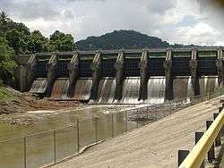
.jpg) The Carraízo Lake / Reservoir | |
 Flag | |
| Nicknames: Ciudad de los Manantiales, El Pueblo de las Ocho Calles, La Ciudad En El Campo, Los Arrecostaos | |
| Anthem: "Duerme Mi Lindo Trujillo" | |
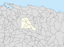
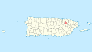 Location of Trujillo Alto in Puerto Rico | |
| Coordinates: 18°21′46″N 66°1′3″W | |
| Commonwealth | |
| Founded | January 8, 1801 |
| Government | |
| • Mayor | José Luis Cruz Cruz (PPD) |
| • Senatorial dist. | 8 - Carolina |
| • Representative dist. | 40 |
| Area | |
| • Total | 21.47 sq mi (55.61 km2) |
| • Land | 21 sq mi (55 km2) |
| • Water | 0.24 sq mi (.61 km2) |
| Elevation | 69 ft (21 m) |
| Population (2010) | |
| • Total | 74,842 |
| • Density | 3,500/sq mi (1,300/km2) |
| Demonym(s) | Trujillanos |
| Time zone | UTC−4 (AST) |
| Zip code | 00976, 00977, 00978 |
| Major routes | |
| Website | www |
Trujillo Alto was officially founded in 1801, but gained more importance during the 20th century. Due to its proximity to the capital, San Juan, the city has become a suburb of the metropolitan area, which has sparked its growth during recent years. The population of Trujillo Alto has increased through the last century from 9,576 (1930) to 74,482 (2010). According to the 2010 Census, it is Puerto Rico's tenth-most populated municipality.[2]
In 1953–54, the Carraízo hydroelectric dam was constructed in Trujillo Alto by the Sumner Sollitt Construction Company of Chicago, under contract by the Puerto Rico Water Resources Authority. The dam forms the Loíza Lake, a reservoir which serves as the main source of the water supply for San Juan, Puerto Rico.[3]
History
The region of what is now Trujillo Alto belonged to the Taíno region of Cayniabón, which stretched from the northeast coast of Puerto Rico into the central region of the island.[4] The region was led by cacique Canobaná. Archeological findings have identified two sites within the municipality of Trujillo Alto with archeological significance: Las Cuevas, which was studied by Irving Rouse, and Quebrada Grande.[5]
After the Spanish colonization, families started settling at both sides of the Río Grande de Loíza. During the 17th Century, the Spanish crown granted Alonso Pizarro Hermona, from Trujillo in Spain, a vast ranch that covered the region. Residents began using his family name to refer to the location. Eventually, the inhabitants went to the Governor and asked for permit to build a chapel, which was a requisite to officially found a town. Despite some opposition, Trujillo Alto was founded on January 8, 1801 under the name of Santa Cruz de Trujillo. Around 1820, the name "Trujillo Alto" was more used to differentiate the town from that of Trujillo Bajo (which later became known as Carolina).[6]
In 1826, communication to and from the town improved with the construction of two bridges: one into Río Piedras, and the other into Río Grande. In 1844, Trujillo Alto was composed of only five wards. A few years later, the first school was built. During that time, population decreased notably due to an epidemic of cholera.
The United States took control of Puerto Rico from Spain in the aftermath of the Spanish-American War under the terms of the Treaty of Paris of 1898. In 1899, the United States conducted its first census of Puerto Rico, finding that the population of Trujillo Alto was 5,683.[7]
In 1902, the Legislative Assembly of Puerto Rico approved a law for the consolidation of certain municipalities. As a result, Trujillo Alto was incorporated into the town of Carolina. However, in 1905 a new law revoked the previous one, turning Trujillo Alto into an independent municipality again.[8]
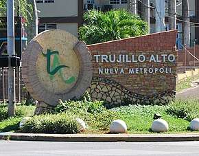
The proximity of the city to the capital, San Juan, has sparked significant growth and development in the region. During the 20th century, the population of Trujillo Alto increased dramatically.[9] As of 2010, the city is the tenth-most populous city of Puerto Rico. Mayor José Luis Cruz Cruz, who has been serving since 2009, has labeled the city as "The New Metropolis".[10]
Hurricane Maria
Hurricane Maria on September 20, 2017 triggered numerous landslides in Trujillo Alto with the significant amount of rainfall.[11][12]
Geography
Trujillo Alto sits on the Northern Coastal Plain region of Puerto Rico. It is bordered by the municipalities of San Juan, Carolina, Gurabo, and Caguas.[8] Trujillo Alto is a small municipality, covering only 21.47 square miles (55.6 km2).[13]
Trujillo Alto's terrain is mostly plain in the north, while the south features small hills. Heights can range from 660–1,600 feet (200–500 meters) above sea level.
Water features
Trujillo Alto's hydrographic system consists mainly of the Río Grande de Loíza (river), which crosses the municipality.[14] There are also several creeks in the city: Colorada, Infierno, Limones, Naranjo, Grande, Pastrana, Haya Fría, and Maracuto.[6]
Also, Trujillo Alto is the site of Puerto Rico's main water reservoir: The Carraízo Dam, at the Loíza Lake. Both were built in 1953 by the Puerto Rico Aqueducts and Sewers Authority (PRASA). Although it was originally built to generate hydroelectricity, it is now used solely as a public water-supply source.[15] The Loíza Lake is also used for sports and recreational fishing.
Barrios
Like all municipalities of Puerto Rico, Trujillo Alto is subdivided into barrios. The municipal buildings, central square and large Catholic church are located in a barrio referred to as "el pueblo".[16][17][18]
- Carraízo
- Cuevas
- Dos Bocas
- La Gloria
- Quebrada Grande
- Quebrada Negrito
- St. Just
- Trujillo Alto barrio-pueblo
Trujillo Alto's townscape is fairly simple. Most of the barrios are spread through the rural section of the city, while the downtown area (Trujillo Alto Pueblo) is small, consisting only of eight primary streets. This gave the city the nickname of the "City of the Eight Streets".[19] Also, there are no high-rise buildings and structures.
Sectors
Barrios (which are like minor civil divisions)[20] in turn are further subdivided into smaller local populated place areas/units called sectores (sectors in English). The types of sectores may vary, from normally sector to urbanización to reparto to barriada to residencial, among others.[21][22][23]
Special Communities
Of the 742 places on the list of Comunidades Especiales de Puerto Rico, the following barrios, communities, sectors, or neighborhoods were in Trujillo Alto: San Nicolás neighborhood, Bethania, Comunidad Talanco, El Hoyo II, El Resbalón, Parcelas Carraízo, Parcelas Ramón T. Colón, Sector Arayanes, Sector La Prá, Sector Las Cruces, Sector Los Nuñez, Villa Escondida, Villa Margarita and Villa Platanal.[24][25]
Tourism
There are several places of interest for tourists to visit in Trujillo Alto. The Bicentenary Walkway, located in the entrance to the city at the PR-181, features the remodeled historic steel bridge as well as a gazebo. It was built in 2001 to commemorate the 200 years of the foundation of Trujillo Alto.
Also on the PR-181, is the Luis Muñoz Marín Foundation which was established in 1980. It includes a museum, a historic archive, and a park.[26]
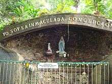
The Carraízo Dam and the Loíza Lake are also frequently visited. Other places of interest are the Convent Carmelitas de San José, the Lourdes Gruta, and the Mountain Spring.
Economy
The economy of Trujillo Alto has relied mostly on agriculture, particularly sugarcane, coffee, tobacco, and minor fruits. Cattle ranching is also a source of economy in Trujillo Alto. In recent years, commerce and industry have become integral parts of the economy of the city. Trujillo Alto is the site of several factories of nutritional products, wood, metal, electrical machinery, and others. There are also stone quarries in town for the production of building materials.
As of 2013, Trujillo Alto's unemployment was 10.2%, making it the second municipality with the lowest rate after Guaynabo.[27]
Culture
Festivals
A number of cultural events take place during the year.[28]
Trujillo Alto's patron saint is the Saint Cross. Its Patron Saint Festival is held each May.[29]
The fifth annual Festival Trujillano de Orquideas (Orchid Festival) was held in July 2016. It is a festival where orchids are exhibited and sold.[30]
The Festival del Macabeo (Macabeo Festival), a festival celebrating a food specific to Trujillo Alto, is celebrated each year around the second week of December.[31]
Other festivals and fairs celebrated in Trujillo Alto include an agricultural fair held in January and a Paso Fino Festival held in November.
In 2001, Trujillo Alto commemorated its bicentenary with the opening of a new park in the PR-181, which included a remodeling of the historical steel bridge.
Religion
There are a number of churches and chapels from several denominations in Trujillo Alto. The main parish, Parroquia Santa Cruz, was built in 1817. Part of a related structure was damaged by Hurricane San Felipe in 1928.[6][32] The current structure was designed by Luis Perocier and built in 1933.[19]
Trujillo Alto has also been a place of pilgrimage for Catholics after a shrine to Our Lady of Lourdes was blessed in 1925. The site also features a grotto dedicated to Our Lady of Lourdes. The Lourdes grotto is visited frequently by religious people and tourists.[33] There's also a convent in Trujillo Alto called the Convento Carmelitas de San José.
Sports
Trujillo Alto doesn't have a professional sports team. However, there are several sports facilities in the city for amateur and novice leagues. In 2011, the Rubén Sánchez Montañez Court in Trujillo Alto, hosted the Cangrejeros de Santurce team of the Baloncesto Superior Nacional (BSN), which is the professional basketball league. The facility has a capacity for 2,250 people.[34]
In September, Trujillo Alto celebrates the Arrecosta'o Marathon, which is one of the most important events in the city. The race has been celebrated yearly since 1985. It originally covered a 6.2 mile (10 kilometer) trajectory around town, but in 2007, it was shortened to 3.1 miles (5 kilometers).[35] In 2010, the marathon was recognized as one of the best organized events of the year.[36]
The Loíza Lake is also a frequent spot for sports and recreational fishing.[37] The lake features a wide variety of fishes like: largemouth bass, peacock bass, sea chubs, tilapia, and beardfish.[38][39][40]
Demographics
| Historical population | |||
|---|---|---|---|
| Census | Pop. | %± | |
| 1900 | 5,683 | — | |
| 1910 | 6,345 | 11.6% | |
| 1920 | 7,470 | 17.7% | |
| 1930 | 9,576 | 28.2% | |
| 1940 | 11,726 | 22.5% | |
| 1950 | 13,605 | 16.0% | |
| 1960 | 18,251 | 34.1% | |
| 1970 | 30,669 | 68.0% | |
| 1980 | 51,389 | 67.6% | |
| 1990 | 61,120 | 18.9% | |
| 2000 | 75,728 | 23.9% | |
| 2010 | 74,842 | −1.2% | |
| U.S. Decennial Census[43] 1899 (shown as 1900)[44] 1910-1930[45] 1930-1950[46] 1960-2000[47] 2010[17] | |||
The population of Trujillo Alto increased steadily during the 20th Century. Since 1920, the population has risen roughly more than 300%. According to the 2010 census, the municipality currently has 74,842 inhabitants. The decade from 2000 to 2010 is the only one that has shown a decrease in population during the last 110 years. Still, Trujillo Alto's current population makes it the tenth municipality in Puerto Rico in terms of population.
According to the 2010 Census, 72% of the population identifies themselves as White, and 14.6% as African-American. Also, 47.5% of the population identified themselves as males, and 52.5% as females. Finally, 25% of the population is under 18 years old. The next biggest percentage of population (20.7%) is between 35 and 49 years old.[48]
Government

Like all municipalities in Puerto Rico, Trujillo Alto is administered by a mayor. The first official mayor of Trujillo Alto was Juan Francisco Carazo, who was one of the residents that vouched for the foundation of the town back in 1801. The current mayor is José Luis Cruz Cruz (from the Popular Democratic Party), who was elected at the 2004 general election.
The city belongs to the Puerto Rico Senatorial district VIII, which is represented by two Senators. In 2012, Pedro A. Rodríguez and Luis Daniel Rivera were elected as District Senators.[49] Representatives Javier Aponte Dalmau (District 38) and Roberto Rivera Ruiz (District 39), both from the PPD, represent different regions of Trujillo Alto in the House of Representatives.
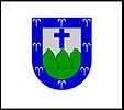
Symbols
Flag and coat of arms
The flag of Trujillo Alto features a white background with the town's coat of arms in the center.
The coat of arms features a shield with a blue border, with eight spurts of water representing the many springs, creeks, and rivers that flow in town. Inside the shield, there's a silver field with three green mountains and a blue Latin cross above them.
The flag features a white banner below the shield with the name of the city, and a coronet in the form of a five-tower mural crown alluding to the Spanish crown. The banner and the coronet aren't featured in the flag.
Nicknames
Trujillo Alto is known by various names. It is known as the "City of Springs" for its many rivers and creeks. It is also known as the "Town of the Eight Streets" because the downtown area consists of eight streets. Trujillo Alto is also known as the "City in the Country", for its proximity to the San Juan Metropolitan Area despite being mostly a mountain town.[19] Finally, it is also called the "Laid-back Town".
Transportation

The main road to Trujillo Alto is the PR-181 that crosses the municipality from north to south. Distance from the capital is roughly 15 minutes.[8] Other highways that lead to Trujillo Alto are the #852 of the Quebrada Grande neighborhood and Dos Bocas, the #175 of the neighborhood Carraízo, the Las Cumbres Avenue and the #851 from La Gloria neighborhood.
In the past, communication with the town was limited because of its location on the other side of the Río Grande de Loíza. The construction of two bridges in 1826 helped facilitate the trip to the town. In 1939, the United States Army built a steel bridge in the entrance to the town on the PR-181, to replace one of the older ones. Although the bridge is no longer used for vehicles, it has become a symbol of the city and still stands today.[5]
The northern part of Trujillo Alto is serviced by the Puerto Rico Metropolitan Bus Authority with various stops along the PR-181 and nearby neighborhoods.[50] Other public transportation in the city is provided by taxis, and independent public cars.
There are 11 bridges in Trujillo Alto.[51]
See also
- List of Puerto Ricans
- History of Puerto Rico
- Did you know-Puerto Rico?
References
- "Geographic coordinates of Trujillo Alto, Puerto Rico". Date and Time info. 2017. (with decimal minutes and elevation). Archived from the original on 2017-09-21. Retrieved 2017-09-20.
- "Población de Puerto Rico por Municipios, 2000 y 2010". Elections Puerto Rico. Archived from the original on 2012-06-03. Retrieved 2013-02-04.
- "USGS - Lago Loíza at Damsite - 50059000". PR Water USGS Gov. Archived from the original on 2016-12-14. Retrieved 2019-03-02.
- "Gobierno Tribal del Pueblo Jatibonicu Taíno de Puerto Rico". webring org. Archived from the original on October 5, 2013. Retrieved February 3, 2013.
- "Historia de Trujillo Alto". Archived from the original on November 4, 2011. Retrieved February 3, 2013.
- "Trujillo Alto". PR Frogui. Archived from the original on February 13, 2013. Retrieved February 3, 2013.
- Joseph Prentiss Sanger; Henry Gannett; Walter Francis Willcox (1900). Informe sobre el censo de Puerto Rico, 1899, United States. War Dept. Porto Rico Census Office (in Spanish). Imprenta del gobierno. p. 162.
- "Trujillo Alto... Pueblo de los Arrecostaos". Proyecto Salon Hogar. Archived from the original on 2009-05-14. Retrieved 2013-02-04.
- "Población de Puerto Rico por Municipios: 1930-2000". CEEPUR. Archived from the original on 2013-03-21.
- "Encaminada la nueva Metropoli 2020". Primera Hora. August 2, 2012. Archived from the original on September 21, 2017. Retrieved February 9, 2013.
- "Preliminary Locations of Landslide Impacts from Hurricane Maria, Puerto Rico". USGS Landslide Hazards Program. USGS. Archived from the original on 2019-03-03. Retrieved 2019-03-03.
- "Preliminary Locations of Landslide Impacts from Hurricane Maria, Puerto Rico" (PDF). USGS Landslide Hazards Program. USGS. Archived (PDF) from the original on 2019-03-03. Retrieved 2019-03-03.
- "Trujillo Alto Municipality". enciclopediapr.org. Fundación Puertorriqueña de las Humanidades (FPH). Archived from the original on 2019-09-27. Retrieved 2019-03-20.
- "Resumen hidrográfico de los ríos de Puerto Rico". YerbaBruja.com. 2013. Archived from the original on July 11, 2013. Retrieved February 3, 2013.
- "Lago Loíza at Damsite". U.S. Geological Survey. January 18, 2008. Archived from the original on April 9, 2009. Retrieved November 19, 2008.
- Gwillim Law (20 May 2015). Administrative Subdivisions of Countries: A Comprehensive World Reference, 1900 through 1998. McFarland. p. 300. ISBN 978-1-4766-0447-3. Retrieved 25 December 2018.
- Puerto Rico:2010:population and housing unit counts.pdf (PDF). U.S. Dept. of Commerce Economics and Statistics Administration U.S. Census Bureau. 2010. Archived (PDF) from the original on 2017-02-20. Retrieved 2018-12-26.
- "Map of Trujillo Alto at the Wayback Machine" (PDF). Archived from the original (PDF) on 2018-03-24. Retrieved 2018-12-29.
- "Trujillo Alto". Ediciones Digitales. Archived from the original on 2011-12-29. Retrieved 2013-02-07.
- "US Census Barrio-Pueblo definition". factfinder.com. US Census. Archived from the original on 13 May 2017. Retrieved 5 January 2019.
- "Agencia: Oficina del Coordinador General para el Financiamiento Socioeconómico y la Autogestión (Proposed 2016 Budget)". Puerto Rico Budgets (in Spanish). Retrieved 28 June 2019.
- Rivera Quintero, Marcia (2014), El vuelo de la esperanza: Proyecto de las Comunidades Especiales Puerto Rico, 1997-2004 (first ed.), San Juan, Puerto Rico Fundación Sila M. Calderón, ISBN 978-0-9820806-1-0
- "Leyes del 2001". Lex Juris Puerto Rico (in Spanish). Retrieved 24 June 2020.
- Rivera Quintero, Marcia (2014), El vuelo de la esperanza:Proyecto de las Comunidades Especiales Puerto Rico, 1997-2004 (Primera edición ed.), San Juan, Puerto Rico Fundación Sila M. Calderón, p. 273, ISBN 978-0-9820806-1-0
- "Comunidades Especiales de Puerto Rico" (in Spanish). 8 August 2011. Archived from the original on 24 June 2019. Retrieved 24 June 2019.
- "Fundación Luis Muñoz Marín, Descripción". FLMM. Archived from the original on 2013-08-12. Retrieved 2013-02-08.
- Santiago, Yaritza (March 1, 2014). "Un pueblo "dormitorio"". Archived from the original on March 9, 2014. Retrieved March 1, 2014.
- "Trujillo Alto: Events". Encyclopedia Puerto Rico. Archived from the original on 2014-04-07. Retrieved 2013-02-07.
- "Fiestas Patronales de Puerto Rico". Proyecto Salon Hogar. Archived from the original on 2013-06-18. Retrieved 2013-02-07.
- "San Juan Metro Events". ¡Qué Pasa! magazine. June–August 2016. Retrieved 14 June 2020 – via Issuu.
- Hernández, José Rafael (28 November 2016). "Anuncian Festival del Macabeo en Trujillo Alto". Periódico Presencia (in Spanish). Retrieved 14 June 2020.
- "Iglesia de Trujillo Alto". Flickr. August 9, 1933. Archived from the original on October 31, 2016. Retrieved July 10, 2016.
- Felices Sánchez, Fernando. "La Gruta de Lourdes en Trujillo Alto:ochenta años peregrinando en la Fe y la Caridad". LaGrutadeLourdes.org. Archived from the original on 2013-09-28. Retrieved 2013-02-08.
- Piñeiro, Noel (February 11, 2011). "Luce bien Trujillo Alto". El Nuevo Día.
- "El Maratón del Arrecostao". Trujillo Alto. November 25, 2009. Archived from the original on November 5, 2011. Retrieved February 8, 2013.
- "Regresa el 5K El Arrecosta'o a beneficio del Hospital Oncológico". El Nuevo Día.
- "Anuncian limpieza del Lago Carraízo". Regional Digital. September 28, 2012. Archived from the original on October 6, 2012. Retrieved February 9, 2013.
- "Sitios para pescar". Carraizo.com. Archived from the original on 2010-08-12. Retrieved 2013-02-09.
- "Embalse Carraizo". LobinaPR.com. 2011. Archived from the original on 2009-06-12. Retrieved 2013-02-09.
- "Lagos y Embalses de Puerto Rico". Proyecto Salon Hogar. Archived from the original on 2014-07-19. Retrieved 2013-02-09.
- "Celebran Festival del Macabeo en Trujillo Alto". El Nuevo Día. December 15, 2012. Archived from the original on December 20, 2012. Retrieved February 9, 2013.
- "Celebran Festival del Macabeo en Trujillo Alto". Primera Hora. December 1, 2011.
- "U.S. Decennial Census". United States Census Bureau. Archived from the original on February 13, 2020. Retrieved September 21, 2017.
- "Report of the Census of Porto Rico 1899". War Department Office Director Census of Porto Rico. Archived from the original on July 16, 2017. Retrieved September 21, 2017.
- "Table 3-Population of Municipalities: 1930 1920 and 1910" (PDF). United States Census Bureau. Archived (PDF) from the original on August 17, 2017. Retrieved September 21, 2017.
- "Table 4-Area and Population of Municipalities Urban and Rural: 1930 to 1950" (PDF). United States Census Bureau. Archived (PDF) from the original on August 30, 2015. Retrieved September 21, 2014.
- "Table 2 Population and Housing Units: 1960 to 2000" (PDF). United States Census Bureau. Archived (PDF) from the original on July 24, 2017. Retrieved September 21, 2017.
- "2010 Census Interactive Population Search: Trujillo Alto, Puerto Rico". US Census 2010. Archived from the original on 2013-07-27. Retrieved 2017-12-10.
- Elecciones Generales 2012: Escrutinio General Archived 2013-01-08 at the Wayback Machine on CEEPUR
- "Información General". Departamento de Transportación y Obras Públicas (DTOP). Archived from the original on 2012-12-03. Retrieved 2013-02-06.
- "Trujillo Alto Bridges". National Bridge Inventory Data. US Dept. of Transportation. Archived from the original on 20 February 2019. Retrieved 19 February 2019.
External links
- Trujillo Alto and its barrios, United States Census Bureau
- Trujillo Alto, Puerto Rico: The City In The Country/La Ciudad En El Campo by Greg Boudonck and Maria M. Ruiz O'Farrill
- Trujillo Alto Municipality on Facebook
- News out of Trujillo Alto on Presencia PR