List of counties in New Mexico
This is a list of the 33 counties in New Mexico. There were originally nine counties formed in 1852. Santa Ana County, New Mexico Territory, one of the nine original counties, was annexed in 1876 to Bernalillo County, New Mexico.
| Counties of New Mexico | |
|---|---|
| Location | State of New Mexico |
| Number | 33 |
| Populations | 625 (Harding) – 679,121 (Bernalillo) |
| Areas | 109 square miles (280 km2) (Los Alamos) – 6,928 square miles (17,940 km2) (Catron) |
| Government | County government |
| Subdivisions | cities, towns, townships, unincorporated communities, indian reservations, Pueblo, census designated place |


The Federal Information Processing Standard (FIPS) code, which is used by the United States government to uniquely identify states and counties, is provided with each entry.[1] New Mexico's code is 35, which when combined with any county code would be written as 35XXX. The FIPS code for each county links to census data for that county.
List
For comparison, the population estimate for the state of New Mexico as of July 2011 was 2,082,224, and the area was 121,589 mi² (315,194 km²).
| County | FIPS code [2] |
County seat [3] |
Est. [3] |
Formed from [4] |
Etymology [5] |
Pop. [6] |
Area [3][7] |
Map |
|---|---|---|---|---|---|---|---|---|
| Bernalillo County | 001 | Albuquerque | 1852 | One of the nine original counties. | The Gonzales-Bernal family, Spanish nobles who settled the territory in the seventeenth century | 679,121 | 1,166 mi² (3,020 km²) | 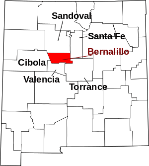 |
| Catron County | 003 | Reserve | 1921 | Part of Socorro County. | Thomas Benton Catron (1840-1921), a Santa Fe attorney and New Mexico's first U.S. Senator | 3,527 | 6,928 sq mi (17,943 km2) |  |
| Chaves County | 005 | Roswell | 1889 | Part of Lincoln County. | Jose Francisco Chaves (1833-1904), a U.S. Army colonel in New Mexico during and after the Civil War | 64,615 | 6,071 sq mi (15,724 km2) |  |
| Cibola County | 006 | Grants | 1981 | Parts of Valencia County, Socorro County, McKinley County, and Catron County. | The mythical Seven Cities of Cibola | 26,675 | 4,540 sq mi (11,759 km2) | 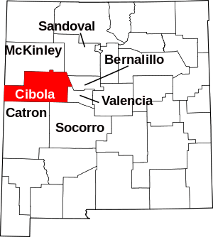 |
| Colfax County | 007 | Raton | 1869 | Part of Mora County. | Schuyler Colfax (1823-1885), the seventeenth vice president of the United States | 11,941 | 3,757 sq mi (9,731 km2) | 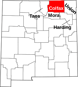 |
| Curry County | 009 | Clovis | 1909 | Parts of Quay County and Roosevelt County. | George Curry (1861-1947), a governor of New Mexico Territory from 1907 to 1910 | 48,954 | 1,406 sq mi (3,642 km2) |  |
| De Baca County | 011 | Fort Sumner | 1917 | Parts of Chaves County and Guadalupe County. | Ezequiel Cabeza de Baca (1864-1917), the second state governor of New Mexico | 1,748 | 2,325 sq mi (6,022 km2) | 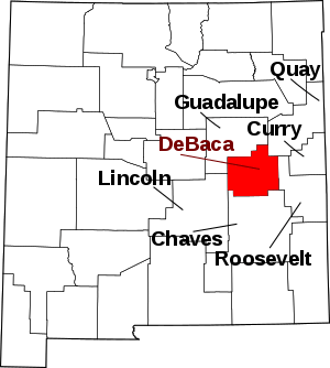 |
| Doña Ana County | 013 | Las Cruces | 1852 | One of the nine original counties. | Doña Ana Robledo, a seventeenth-century Spanish woman known for her charitable giving to the native population | 218,195 | 3,807 sq mi (9,860 km2) | 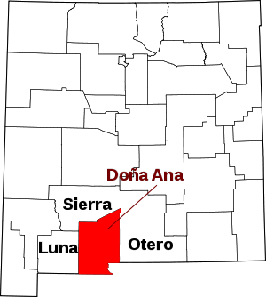 |
| Eddy County | 015 | Carlsbad | 1887 | Part of Lincoln County. | Charles Eddy (1857 - 1931), a rancher and developer of the area | 58,460 | 4,182 sq mi (10,831 km2) | 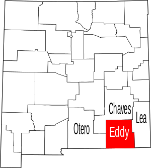 |
| Grant County | 017 | Silver City | 1868 | Part of Doña Ana County. | Ulysses Simpson Grant (1822-1885), the Civil War general and eighteenth president of the United States | 26,998 | 3,966 sq mi (10,272 km2) |  |
| Guadalupe County | 019 | Santa Rosa | 1891 | Part of San Miguel County. | Our Lady of Guadalupe, the patron saint of the Americas | 4,300 | 3,031 sq mi (7,850 km2) |  |
| Harding County | 021 | Mosquero | 1921 | Parts of Mora County and Union County. | Warren Gamaliel Harding (1865-1923), the twenty-ninth president of the United States | 625 | 2,126 sq mi (5,506 km2) |  |
| Hidalgo County | 023 | Lordsburg | 1920 | Part of Grant County. | The Treaty of Guadalupe Hidalgo, named after a Mexican town in turn named for Miguel Hidalgo y Costilla (1753 - 1811), the priest who is known as the Father of Mexican Independence | 4,198 | 3,446 sq mi (8,925 km2) |  |
| Lea County | 025 | Lovington | 1917 | Parts of Chaves County and Eddy County. | Joseph Calloway Lea (1841-1904), a captain in the U.S. Army and the founder of the New Mexico Military Academy | 71,070 | 4,393 sq mi (11,378 km2) |  |
| Lincoln County | 027 | Carrizozo | 1869 | Part of Socorro County. | Abraham Lincoln (1809-1865), the sixteenth president of the United States | 19,572 | 4,831 sq mi (12,512 km2) |  |
| Los Alamos County | 028 | Los Alamos | 1949 | Parts of Sandoval County and Santa Fe County. | Named for its county seat of Los Alamos, New Mexico, which itself is the Spanish name for the cottonwood tree | 19,369 | 109 sq mi (282 km2) |  |
| Luna County | 029 | Deming | 1901 | Parts of Doña Ana County and Grant County. | Solomon Luna (1858 - 1912), the largest land owner in the county at the time of its creation; itself Spanish for moon | 23,709 | 2,965 sq mi (7,679 km2) | 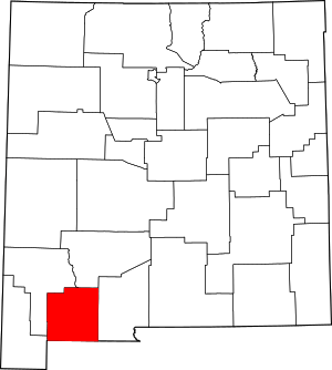 |
| McKinley County | 031 | Gallup | 1899 | Part of Bernalillo County. | William McKinley (1843-1901), the twenty-fifth president of the United States | 71,367 | 5,449 sq mi (14,113 km2) | 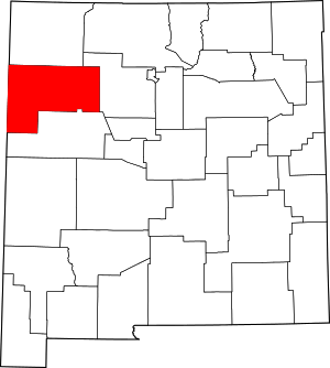 |
| Mora County | 033 | Mora | 1859 | Part of Taos County. | Named for its county seat of Mora, New Mexico, which is itself named after lo de mora, the Spanish term for blackberry | 4,521 | 1,931 sq mi (5,001 km2) | 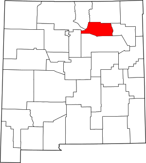 |
| Otero County | 035 | Alamogordo | 1899 | Parts of Doña Ana County and Lincoln County. | Miguel A. Otero (1829-1882), territorial delegate to U. S. Congress or Miguel Antonio Otero (II) (1859-1944), 16th Governor of New Mexico Territory from 1897 to 1906 | 67,490 | 6,627 sq mi (17,164 km2) | 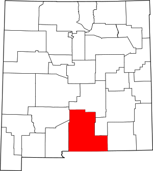 |
| Quay County | 037 | Tucumcari | 1903 | Part of Guadalupe County. | Matthew Stanley Quay (1833-1904), a U.S. Senator from Pennsylvania who supported New Mexico's statehood | 8,253 | 2,855 sq mi (7,394 km2) | 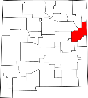 |
| Rio Arriba County | 039 | Tierra Amarilla | 1852 | One of the nine original counties. | Named for its location on the upper Rio Grande (Río Arriba means "upstream" or "up the river" in Spanish) | 38,921 | 5,858 sq mi (15,172 km2) | 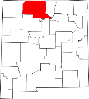 |
| Roosevelt County | 041 | Portales | 1903 | Parts of Chaves County and Guadalupe County. | Theodore Roosevelt (1858-1919), the twenty-sixth president of the United States | 18,500 | 2,449 sq mi (6,343 km2) | 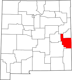 |
| Sandoval County | 043 | Bernalillo | 1903 | Part of Bernalillo County. | Named for the Sandoval family, prominent seventeenth-century Spanish landowners | 146,748 | 3,710 sq mi (9,609 km2) | 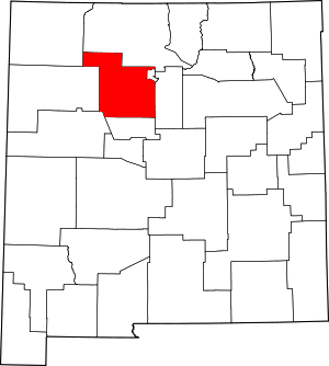 |
| San Juan County | 045 | Aztec | 1887 | Part of Rio Arriba County. | San Juan River, itself named after the Catholic saint | 123,958 | 5,514 sq mi (14,281 km2) |  |
| San Miguel County | 047 | Las Vegas | 1852 | One of the nine original counties. | San Miguel de Bado Catholic Church, the first in the area | 27,277 | 4,717 sq mi (12,217 km2) | 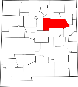 |
| Santa Fe County | 049 | Santa Fe | 1852 | One of the nine original counties. | Spanish term meaning "holy faith," which refers to the spirituality of the founding missionaries | 150,358 | 1,909 sq mi (4,944 km2) | 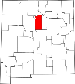 |
| Sierra County | 051 | Truth or Consequences | 1884 | Parts of Doña Ana County and Socorro County. | Possibly named for the Black Range. (Sierra is mountain range in Spanish.) | 10,791 | 4,180 sq mi (10,826 km2) | 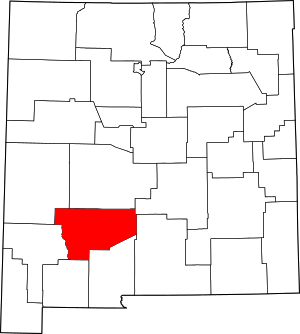 |
| Socorro County | 053 | Socorro | 1852 | One of the nine original counties. | Spanish term meaning "aid," which refers to the help Native Americans gave to starving travelers | 16,637 | 6,647 sq mi (17,216 km2) |  |
| Taos County | 055 | Taos | 1852 | One of the nine original counties. | Named for its county seat of Taos, New Mexico, which in turn was named for the nearby Taos Pueblo, an ancient Native American village. Taos is red willow in the Tiwa language | 32,723 | 2,203 sq mi (5,706 km2) |  |
| Torrance County | 057 | Estancia | 1903 | Parts of Bernalillo County, Valencia County, and Socorro County. | Francis J. Torrance (1859 - 1919), the developer of the New Mexico Central Railroad | 15,461 | 3,345 sq mi (8,664 km2) | 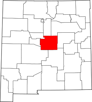 |
| Union County | 059 | Clayton | 1893 | Parts of Colfax County, Mora County and San Miguel County. | Named for the "union" of the three counties which donated land to form the new county | 4,059 | 3,830 sq mi (9,920 km2) |  |
| Valencia County | 061 | Los Lunas | 1852 | One of the nine original counties. | Named for the town of Valencia, New Mexico, which is itself named for Valencia, Spain | 76,688 | 1,068 sq mi (2,766 km2) | 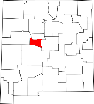 |
Former counties
- Arizona County, New Mexico Territory, is mentioned in the 1860 United States Census.[8]
- Mesilla County, appears on 1860s-era territorial map encompassing area in present-day Dona Aña, Grant, Hidalgo, Luna, Sierra west of the Rio Grande
- Santa Ana County (1844–1876) absorbed by Bernalillo County; portions are in present-day McKinley County
- Santa Fe County, Texas (1848-1850), never organized, included the portion of New Mexico east of the Rio Grande except for southeastern New Mexico east of the Pecos River and south of the Prairie Dog Town Fork Red River as well as the Trans-Pecos and most of the Panhandle regions of Texas, the Oklahoma Panhandle, and portions of Colorado, Kansas, and Wyoming. Before Texas ceded its western lands to the federal government after the Compromise of 1850, the following counties were briefly created from Santa Fe County earlier that year in south-central New Mexico between the Rio Grande and the Pecos:
References
- "FIPS Publish 6-4". National Institute of Standards and Technology. Archived from the original on 2013-09-29. Retrieved 2007-08-06.
- "EPA County FIPS Code Listing". US Environmental Protection Agency. Retrieved 2007-08-06.
- "NACo - Find a county". National Association of Counties. Archived from the original on 2007-09-30. Retrieved 2007-08-07.
- "NMGenWeb Counties". Rootsweb.com. Archived from the original on 2007-07-02. Retrieved 2007-08-06.
- Viva New Mexico County Names Archived 2008-07-04 at the Wayback Machine
- "co-est2019-alldata.csv". U.S. Census Bureau. Retrieved June 5, 2020.
- "New Mexico QuickFacts". U.S. Census Bureau. Archived from the original on 2011-12-27. Retrieved 2007-08-07. (2000 Census)
- https://www2.census.gov/library/publications/decennial/1860/population/1860a-42.pdf
External links
- "Historical Sidebar: New Mexico Counties". Archived from the original on 2008-07-04.
- Maps of historic New Mexico counties
Santa Fe (capital) | ||
| Topics |
| |
| Society | ||
| Regions |
| |
| Cities | ||
| Counties | ||
This article is issued from Wikipedia. The text is licensed under Creative Commons - Attribution - Sharealike. Additional terms may apply for the media files.