Menominee County, Wisconsin
Menominee County is a county in the U.S. state of Wisconsin. As of the 2010 census, the population was 4,232[1] making it the least populous county in Wisconsin. Its county seat is Keshena.[2]
Menominee County | |
|---|---|
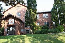 Menominee Indian Tribal Offices in Keshena, Wisconsin. | |
 Location within the U.S. state of Wisconsin | |
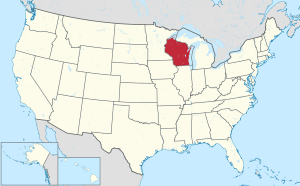 Wisconsin's location within the U.S. | |
| Coordinates: 45°01′N 88°42′W | |
| Country | |
| State | |
| Founded | July 3, 1959 |
| Named for | Menominee tribe |
| Seat | Keshena |
| Largest town | Menominee |
| Area | |
| • Total | 365 sq mi (950 km2) |
| • Land | 358 sq mi (930 km2) |
| • Water | 7.4 sq mi (19 km2) 2.0%% |
| Population (2010) | |
| • Total | 4,232 |
| • Estimate (2018) | 4,658 |
| • Density | 12/sq mi (4.5/km2) |
| Time zone | UTC−6 (Central) |
| • Summer (DST) | UTC−5 (CDT) |
| Congressional district | 8th |
| Website | www |
Menominee is Wisconsin's newest county, having been created in 1959 after the Menominee tribe was terminated by federal law. In 1974, the tribe regained federal recognition and restoration of most of its reservation. Today Menominee County is essentially coterminous with the boundaries of the federally recognized Menominee Indian Reservation.
Menominee County is included in the Shawano, WI Micropolitan Statistical Area, which is also included in the Green Bay-Shawano, WI Combined Statistical Area.
History
The county was created from the northeastern portion of Shawano County on July 3, 1959, in anticipation of the termination of the Menominee Indian Reservation in 1961. The reservation status was restored in 1973, and is now co-extensive with the county.
Most of the land within the county boundary is under Federal trust for the exclusive use by enrolled members of the Menominee nation. Scattered parcels that were purchased during termination, as well as many lots around the Legend Lake area in the southeastern part of the county, are the only parts of the county that are privately owned by non-Native Americans. Most of Menominee County's population consists of members of the Menominee nation.[3]
Geography
According to the U.S. Census Bureau, the county has a total area of 365 square miles (950 km2), of which 358 square miles (930 km2) is land and 7.4 square miles (19 km2) (2.0%) is water.[4] It is the second-smallest county in Wisconsin by total area.
Adjacent counties
- Oconto County - east
- Shawano County - south
- Langlade County - northwest
Major highways


Demographics
| Historical population | |||
|---|---|---|---|
| Census | Pop. | %± | |
| 1970 | 2,607 | — | |
| 1980 | 3,373 | 29.4% | |
| 1990 | 3,890 | 15.3% | |
| 2000 | 4,562 | 17.3% | |
| 2010 | 4,232 | −7.2% | |
| Est. 2018 | 4,658 | [5] | 10.1% |
| U.S. Decennial Census[6] 1900–1990[7] 1990–2000[8] 2010–2018[1] | |||

At the 2000 census there were 4,562 people, 1,345 households, and 1,065 families in the county. This total makes it the least-populated county in the state. The population density was 13 people per square mile (5/km²). There were 2,098 housing units at an average density of 6 per square mile (2/km²). The racial makeup of the county was 11.57% White, 0.07% Black or African American, 87.26% Native American, 0.02% Pacific Islander, 0.33% from other races, and 0.75% from two or more races. 2.67%.[9] were Hispanic or Latino of any race. 5.0% were of German ancestry. 89.8% spoke English, 7.0% Menominee and 1.6% Hmong as their first language.
Of the 1,345 households 42.20% had children under the age of 18 living with them, 42.50% were married couples living together, 26.60% had a female householder with no husband present, and 20.80% were non-families. 16.50% of households were one person and 6.40% were one person aged 65 or older. The average household size was 3.35 and the average family size was 3.66.
The age distribution was 38.90% under the age of 18, 8.40% from 18 to 24, 24.70% from 25 to 44, 19.50% from 45 to 64, and 8.50% 65 or older. The median age was 28 years. For every 100 females there were 97.30 males. For every 100 females age 18 and over, there were 92.30 males.
In 2017, there were 89 births, giving a general fertility rate of 115.9 births per 1000 women aged 15–44, the highest rate out of all 72 Wisconsin counties.[10]
Politics
In presidential elections, Menominee County has always voted for the Democratic candidate and always by a higher percentage than all other Wisconsin counties. In 2016, Donald Trump became the first Republican to win over 20% of the vote in the county since George H. W. Bush in 1992.
| Year | Republican | Democratic | Third parties |
|---|---|---|---|
| 2016 | 20.4% 267 | 76.6% 1,002 | 3.0% 39 |
| 2012 | 13.0% 179 | 86.5% 1,191 | 0.5% 7 |
| 2008 | 12.8% 185 | 86.8% 1,257 | 0.4% 6 |
| 2004 | 16.8% 288 | 82.6% 1,412 | 0.6% 10 |
| 2000 | 18.2% 225 | 77.0% 949 | 4.8% 59 |
| 1996 | 17.0% 230 | 73.5% 992 | 9.5% 128 |
| 1992 | 21.0% 244 | 59.6% 691 | 19.4% 225 |
| 1988 | 26.9% 381 | 72.5% 1,028 | 0.6% 8 |
| 1984 | 31.8% 392 | 67.6% 832 | 0.6% 7 |
| 1980 | 32.3% 302 | 58.1% 544 | 9.6% 90 |
| 1976 | 28.9% 324 | 68.3% 766 | 2.9% 32 |
| 1972 | 36.4% 355 | 62.3% 608 | 1.3% 13 |
| 1968 | 24.2% 179 | 71.8% 531 | 4.1% 30 |
| 1964 | 10.7% 78 | 89.1% 647 | 0.1% 1 |
Communities


Menominee County is one of only two counties in Wisconsin with no incorporated communities, the other being Florence County.
Town
Census-designated places
- Keshena (county seat)
- Legend Lake
- Middle Village (partial)
- Neopit
- Zoar
Ghost town/neighborhood
References
- "State & County QuickFacts". United States Census Bureau. Archived from the original on June 6, 2011. Retrieved January 22, 2014.
- "Find a County". National Association of Counties. Retrieved June 7, 2011.
- Paxton Hart. "The Making of Menominee County". Wisconsin Magazine of History, vol. 143, no. 3 (Spring 1960):181-189.
- "2010 Census Gazetteer Files". United States Census Bureau. August 22, 2012. Retrieved August 6, 2015.
- "Population and Housing Unit Estimates". Retrieved July 26, 2019.
- "U.S. Decennial Census". United States Census Bureau. Retrieved August 6, 2015.
- Forstall, Richard L., ed. (March 27, 1995). "Population of Counties by Decennial Census: 1900 to 1990". United States Census Bureau. Retrieved August 6, 2015.
- "Census 2000 PHC-T-4. Ranking Tables for Counties: 1990 and 2000" (PDF). United States Census Bureau. April 2, 2001. Retrieved August 6, 2015.
- "U.S. Census website". United States Census Bureau. Retrieved May 14, 2011.
- "Annual Wisconsin Birth and Infant Mortality Report, 2017 P-01161-19 (June 2019): Detailed Tables". Archived from the original on 2019-06-19. Retrieved 2019-06-19.
- Leip, David. "Dave Leip's Atlas of U.S. Presidential Elections". uselectionatlas.org. Retrieved August 14, 2018.
External links
- Menominee County government website
- Menominee County map from the Wisconsin Department of Transportation
Places adjacent to Menominee County, Wisconsin | ||||||||||
|---|---|---|---|---|---|---|---|---|---|---|
| ||||||||||
Municipalities and communities of Menominee County, Wisconsin, United States | ||
|---|---|---|
| Town | | |
| CDPs | ||
| Unincorporated community |
| |
| Indian reservation | ||
| Ghost town/neighborhood | ||
| Footnotes | ‡This populated place also has portions in an adjacent county or counties | |
| Authority control |
|
|---|