Borden County, Texas
Borden County is a rural county located in the U.S. state of Texas. As of the 2010 census, its population was 641,[1] making it the fourth-least populous county in Texas. Its county seat is Gail.[2] The county was created in 1876 and later organized in 1891.[3] Gail and Borden County are named for Gail Borden, Jr., businessman, publisher, surveyor, and inventor of condensed milk. Borden County is one of six prohibition or entirely dry counties in the state of Texas.[4]
Borden County | |
|---|---|
 Borden County Courthouse in Gail | |
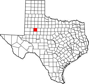 Location within the U.S. state of Texas | |
 Texas's location within the U.S. | |
| Coordinates: 32°44′N 101°26′W | |
| Country | |
| State | |
| Founded | 1876 |
| Named for | Gail Borden, Jr. |
| Seat | Gail |
| Largest community | Gail |
| Area | |
| • Total | 906 sq mi (2,350 km2) |
| • Land | 897 sq mi (2,320 km2) |
| • Water | 8.6 sq mi (22 km2) 1.0%% |
| Population (2010) | |
| • Total | 641 |
| • Density | 0.7/sq mi (0.3/km2) |
| Time zone | UTC−6 (Central) |
| • Summer (DST) | UTC−5 (CDT) |
| Congressional district | 19th |
| Website | www |
History
County established
Borden County was created in 1876 from Bosque County and named for Gail Borden, Jr., the inventor of condensed milk. Borden was publisher and editor of the Telegraph and Texas Register, as well as a political leader in the Republic of Texas. The county was organized in 1891, and Gail was made the county seat.[6]
Farmers and ranchers settled the county, but the population remained relatively small. In 1902, Texas placed lands in the public domain and spurred a land rush in Borden County. Many of the newcomers grew cotton.[5]
Borden County has had two courthouses, one built in 1890. The current courthouse is of brick and concrete construction and was erected in 1939. The architect was David S. Castle Co.[7]
Oil was discovered in the county in 1949. By 1991, more than 340,000,000 barrels (54,000,000 m3) of petroleum had been taken out of Borden County since its discovery.[8]
Geography
According to the U.S. Census Bureau, the county has a total area of 906 square miles (2,350 km2), of which 897 square miles (2,320 km2) are land and 8.6 square miles (22 km2) (1.0%) are covered by water.[9]
Major highways


Adjacent counties
- Garza County (north)
- Scurry County (east)
- Mitchell County (southeast)
- Howard County (south)
- Dawson County (west)
- Lynn County (northwest)
Demographics
| Historical population | |||
|---|---|---|---|
| Census | Pop. | %± | |
| 1880 | 35 | — | |
| 1890 | 222 | 534.3% | |
| 1900 | 776 | 249.5% | |
| 1910 | 1,386 | 78.6% | |
| 1920 | 965 | −30.4% | |
| 1930 | 1,505 | 56.0% | |
| 1940 | 1,396 | −7.2% | |
| 1950 | 1,106 | −20.8% | |
| 1960 | 1,076 | −2.7% | |
| 1970 | 888 | −17.5% | |
| 1980 | 859 | −3.3% | |
| 1990 | 799 | −7.0% | |
| 2000 | 729 | −8.8% | |
| 2010 | 641 | −12.1% | |
| Est. 2019 | 654 | [10] | 2.0% |
| U.S. Decennial Census[11] 1850–2010[12] 2010–2014[1] | |||
As of the census[13] of 2000, 729 people, 292 households, and 216 families resided in the county. The population density was 0.80 people per square mile (0.31/km)2. The 435 housing units averaged 0.48 per square mile (0.19/km2). The racial makeup of the county was 90.53% White, 0.14% African American, 0.27% Native American, 6.31% from other races, and 2.74% from two or more races. About 11.93% of the population was Hispanic or Latino of any race.
Of the 292 households, 30.10% had children under the age of 18 living with them, 65.10% were married couples living together, 6.20% had a female householder with no husband present, and 25.70% were not families. Around 22.60% of all households consisted of individuals, and 9.20% had someone living alone who was 65 years of age or older. The average household size was 2.50 and the average family size was 2.93.
In the county, the population was distributed as 24.60% under the age of 18, 6.70% from 18 to 24, 27.40% from 25 to 44, 25.00% from 45 to 64, and 16.30% who were 65 years of age or older. The median age was 40 years. For every 100 females, there were 103.10 males. For every 100 females age 18 and over, there were 108.30 males.
The median income for a household in the county was $29,205, and for a family was $36,458. Males had a median income of $25,556 versus $21,607 for females. The per capita income for the county was $18,364. About 14.00% of the population and 11.80% of families were below the poverty line. Of the total people living in poverty, 14.30% were under the age of 18 and 11.60% were 65 or older.
The county is served by nearby radio stations KBXJ (FM) and KPET (AM), and the various Midland and Odessa radio and TV stations.
The largest self-reported ancestry groups in Borden County are:[14] · English – 17% · Irish – 15% · German – 12% · Mexican – 9% · French (except Basque) – 3% · Scotch-Irish – 3% · Other Hispanic or Latino – 3% · Scottish – 2% · Spanish – 1% · American Indian tribes, specified – 1%
Education
The county is served mostly by Borden County Independent School District. The district offers kindergarten through 12th grade. Borden County School is among the few public schools in Texas to receive a distinguished GreatSchools rating of 9 out of 10.[15] Many of the teachers reside in board-owned housing in Gail. The school offers six-man football,[16] basketball,[17] baseball, tennis, softball, UIL, FFA, and track.
Media
The weekly newspaper, the Borden Star, covers events for the school and county.
Communities
No incorporated towns are in Borden County, Texas.
Unincorporated towns:
Gallery
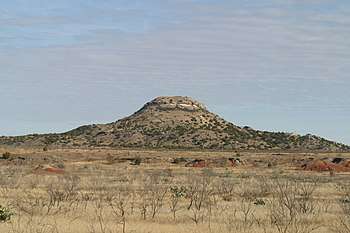 Mushaway Peak viewed from Willow Valley Road
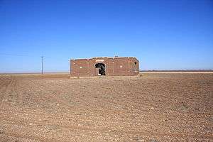 Abandoned schoolhouse in the ghost town of Mesquite
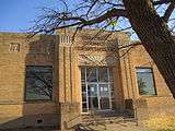 Frontal view of Borden County Courthouse
 Coyote Country Store across from the courthouse is one of the few businesses in Borden County
 Gail Mountain viewed from Willow Valley Road
 First Baptist Church in Gail
Politics
| Year | Republican | Democratic | Third parties |
|---|---|---|---|
| 2016 | 90.4% 330 | 8.5% 31 | 1.1% 4 |
| 2012 | 89.3% 324 | 8.8% 32 | 1.9% 7 |
| 2008 | 87.5% 316 | 11.1% 40 | 1.4% 5 |
| 2004 | 84.4% 303 | 15.3% 55 | 0.3% 1 |
| 2000 | 80.2% 283 | 17.6% 62 | 2.3% 8 |
| 1996 | 58.1% 194 | 27.8% 93 | 14.1% 47 |
| 1992 | 48.7% 184 | 28.0% 106 | 23.3% 88 |
| 1988 | 62.3% 283 | 37.2% 169 | 0.4% 2 |
| 1984 | 69.4% 325 | 29.9% 140 | 0.6% 3 |
| 1980 | 67.2% 279 | 31.6% 131 | 1.2% 5 |
| 1976 | 38.5% 150 | 60.0% 234 | 1.5% 6 |
| 1972 | 76.2% 330 | 22.2% 96 | 1.6% 7 |
| 1968 | 30.3% 117 | 40.7% 157 | 29.0% 112 |
| 1964 | 36.3% 152 | 63.5% 266 | 0.2% 1 |
| 1960 | 40.4% 166 | 56.0% 230 | 3.7% 15 |
| 1956 | 34.5% 127 | 65.2% 240 | 0.3% 1 |
| 1952 | 46.4% 182 | 53.6% 210 | |
| 1948 | 7.7% 18 | 87.1% 203 | 5.2% 12 |
| 1944 | 11.0% 34 | 77.0% 237 | 12.0% 37 |
| 1940 | 10.5% 44 | 89.5% 375 | |
| 1936 | 10.5% 26 | 88.7% 220 | 0.8% 2 |
| 1932 | 2.8% 7 | 97.2% 242 | |
| 1928 | 57.3% 98 | 42.7% 73 | |
| 1924 | 10.4% 10 | 89.6% 86 | |
| 1920 | 3.8% 4 | 84.8% 89 | 11.4% 12 |
| 1916 | 1.1% 1 | 92.3% 84 | 6.6% 6 |
| 1912 | 0.8% 1 | 97.7% 128 | 1.5% 2 |
See also
- Dry counties
- Recorded Texas Historic Landmarks in Borden County
References
- "State & County QuickFacts". United States Census Bureau. Archived from the original on September 5, 2015. Retrieved December 8, 2013.
- "Find a County". National Association of Counties. Archived from the original on May 31, 2011. Retrieved June 7, 2011.
- "Texas: Individual County Chronologies". Texas Atlas of Historical County Boundaries. The Newberry Library. 2008. Retrieved May 20, 2015.
- "Wet/Dry Status of Texas Counties as of November 2018". Texas Alcoholic Beverage Commission. Retrieved July 29, 2018.
- Leffler, John; Hunt, William R. "Borden County, Texas". Handbook of Texas Online. Texas State Historical Association. Retrieved December 13, 2010.
- Hunt, William R. "Gail, Texas". Handbook of Texas Online. Texas State Historical Association. Retrieved December 13, 2010.
- "Borden County Courthouse". Texas Escapes. Blueprints For Travel, LLC. Retrieved December 13, 2010.
- Olien, Roger M; Hinton, Diana Davids (2007). Wildcatters: Texas Independent Oilmen. TAMU Press. p. 99. ISBN 978-1-58544-606-3.
- "2010 Census Gazetteer Files". United States Census Bureau. August 22, 2012. Retrieved April 19, 2015.
- "Population and Housing Unit Estimates". United States Census Bureau. May 24, 2020. Retrieved May 27, 2020.
- "U.S. Decennial Census". United States Census Bureau. Retrieved April 19, 2015.
- "Texas Almanac: Population History of Counties from 1850–2010" (PDF). Texas Almanac. Retrieved April 19, 2015.
- "U.S. Census website". United States Census Bureau. Retrieved May 14, 2011.
- "Borden County, TX – Borden County, Texas – Ancestry & family history – ePodunk". epodunk.com. Archived from the original on March 4, 2016. Retrieved July 19, 2018.
- "Borden County School". greatschools.org. Retrieved April 5, 2011.
- "Texas Bowl". sixmanfootball.com. Retrieved April 5, 2011.
- "Borden High School Basketball". maxpreps.com. Retrieved April 5, 2011.
- Leip, David. "Dave Leip's Atlas of U.S. Presidential Elections". uselectionatlas.org. Retrieved July 19, 2018.
External links
- Borden County government
- Borden County from the Handbook of Texas Online
- Borden County from the Texas Almanac
- Borden County from the TXGenWeb Project
- Borden County Profile from the Texas Association of Counties
- Photos of West Texas and Llano Estacado
Places adjacent to Borden County, Texas | ||||||||||
|---|---|---|---|---|---|---|---|---|---|---|
| ||||||||||
Municipalities and communities of Borden County, Texas, United States | ||
|---|---|---|
| CDP | Borden County map | |
| Other unincorporated community | ||
| Ghost town | ||

| Authority control |
|
|---|