Maple Springs, Minnesota
| Maple Springs, Minnesota | |
|---|---|
| Unincorporated community | |
.jpg) Amtrak's Empire Builder passes through Maple Springs in 2009 | |
 Maple Springs, Minnesota Location of the community of Maple Springs within Pepin Township, Wabasha County  Maple Springs, Minnesota Maple Springs, Minnesota (the US) | |
| Coordinates: 44°24′35″N 92°09′43″W / 44.40972°N 92.16194°WCoordinates: 44°24′35″N 92°09′43″W / 44.40972°N 92.16194°W | |
| Country | United States |
| State | Minnesota |
| County | Wabasha County |
| Township | Pepin Township |
| Elevation | 764 ft (233 m) |
| Time zone | UTC-6 (Central (CST)) |
| • Summer (DST) | UTC-5 (CDT) |
| ZIP code | 55041 |
| Area code(s) | 651 |
| GNIS feature ID | 654818[1] |
Maple Springs is an unincorporated community in Pepin Township, Wabasha County, Minnesota, United States, along the Mississippi River and Lake Pepin. The Mississippi River and King Creek meet at Maple Springs.
The community is located between Lake City and Wabasha along U.S. Highway 61 at the intersection with 247th Avenue.
Nearby places include Lake City, Wabasha, Camp Lacupolis, and Reads Landing.
Maple Springs was originally named King's Cooley, after a coulee on the farm of a nearby settler named King. It had a station on the former Chicago, Milwaukee and St. Paul Railroad – the "Milwaukee Road".[2]
Local businesses include a fishing resort along Lake Pepin.
References
- ↑ "Maple Springs, Minnesota". Geographic Names Information System. United States Geological Survey.
- ↑ "Minnesota Place Names". Minnesota Historical Society. Retrieved May 9, 2009.
Municipalities and communities of Wabasha County, Minnesota, United States | ||
|---|---|---|
| Cities | 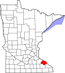 | |
| Townships | ||
| Unincorporated communities | ||
| Footnotes | ‡This populated place also has portions in an adjacent county or counties | |
This article is issued from
Wikipedia.
The text is licensed under Creative Commons - Attribution - Sharealike.
Additional terms may apply for the media files.