High Falls, North Carolina
| High Falls, North Carolina | |
|---|---|
| Unincorporated community | |
 High Falls, North Carolina  High Falls, North Carolina | |
| Coordinates: 35°29′02″N 79°31′18″W / 35.48389°N 79.52167°WCoordinates: 35°29′02″N 79°31′18″W / 35.48389°N 79.52167°W | |
| Country | United States |
| State | North Carolina |
| County | Moore |
| Elevation | 364 ft (111 m) |
| Time zone | UTC-5 (Eastern (EST)) |
| • Summer (DST) | UTC-4 (EDT) |
| ZIP code | 27259 |
| Area code(s) | 910 |
| GNIS feature ID | 1020730[1] |
High Falls is an unincorporated community in Moore County, North Carolina, United States. The community is located along North Carolina Highway 22 and the Deep River 11.2 miles (18.0 km) north-northwest of Carthage. High Falls has a post office with ZIP code 27259.[2][3]
References
- ↑ "High Falls". Geographic Names Information System. United States Geological Survey.
- ↑ United States Postal Service (2012). "USPS - Look Up a ZIP Code". Retrieved February 8, 2015.
- ↑ "Postmaster Finder - Post Offices by ZIP Code". United States Postal Service. Retrieved February 8, 2015.
Municipalities and communities of Moore County, North Carolina, United States | ||
|---|---|---|
| City | 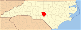 | |
| Towns | ||
| Villages | ||
| CDP | ||
| Unincorporated communities | ||
This article is issued from
Wikipedia.
The text is licensed under Creative Commons - Attribution - Sharealike.
Additional terms may apply for the media files.