Hills and Dales, Kentucky
| Hills and Dales, Kentucky | |
|---|---|
| City | |
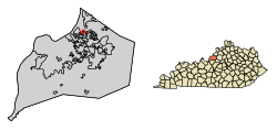 Location of Hills and Dales in Jefferson County, Kentucky | |
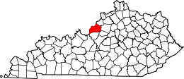
 Hills and Dales Location within the state of Kentucky  Hills and Dales Hills and Dales (the US) | |
| Coordinates: 38°18′1″N 85°37′26″W / 38.30028°N 85.62389°WCoordinates: 38°18′1″N 85°37′26″W / 38.30028°N 85.62389°W | |
| Country | United States |
| State | Kentucky |
| County | Jefferson |
| Incorporated | 1976 |
| Area | |
| • Total | 0.10 sq mi (0.26 km2) |
| • Land | 0.10 sq mi (0.26 km2) |
| • Water | 0.0 sq mi (0.0 km2) |
| Elevation | 600 ft (183 m) |
| Population (2010) | |
| • Total | 142 |
| • Estimate (2016)[1] | 144 |
| • Density | 1,424/sq mi (549.7/km2) |
| Time zone | UTC-5 (Eastern (EST)) |
| • Summer (DST) | UTC-4 (EDT) |
| ZIP Code | 40241 |
| FIPS code | 21-36865 |
| GNIS feature ID | 1669506 |
Hills and Dales is a home rule-class city in Jefferson County, Kentucky, United States. The population was 142 at the 2010 census.[2]
Geography
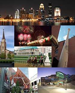
Hills and Dales is located in northeastern Jefferson County at 38°18′01″N 85°37′26″W / 38.300269°N 85.623992°W,[3] on a hill overlooking Goose Creek to the north. Interstate 71 runs along the southern border of the community, but with no direct access. U.S. Route 42 passes through the northwest corner of the community, leading southwest 9 miles (14 km) to downtown Louisville.
According to the United States Census Bureau, the city has a total area of 0.10 square miles (0.26 km2), all land.[2]
Demographics
| Historical population | |||
|---|---|---|---|
| Census | Pop. | %± | |
| 1980 | 151 | — | |
| 1990 | 154 | 2.0% | |
| 2000 | 7,037 | 4,469.5% | |
| 2010 | 142 | −98.0% | |
| Est. 2016 | 144 | [1] | 1.4% |
| U.S. Decennial Census[4] | |||
As of the census[5] of 2000, there were 153 people, 61 households, and 51 families residing in the city. The population density was 1,567.7 people per square mile (590.7/km²). There were 62 housing units at an average density of 635.3 per square mile (239.4/km²). The racial makeup of the city was 96.08% White, 2.61% Asian, and 1.31% from two or more races.
There were 61 households out of which 29.5% had children under the age of 18 living with them, 83.6% were married couples living together, and 14.8% were non-families. 9.8% of all households were made up of individuals and 6.6% had someone living alone who was 65 years of age or older. The average household size was 2.51 and the average family size was 2.69.
In the city, the population was spread out with 20.3% under the age of 18, 2.6% from 18 to 24, 18.3% from 25 to 44, 37.3% from 45 to 64, and 21.6% who were 65 years of age or older. The median age was 52 years. For every 100 females, there were 91.3 males. For every 100 females age 18 and over, there were 93.7 males.
The median income for a household in the city was $80,773, and the median income for a family was $80,888. Males had a median income of $66,250 versus $43,000 for females. The per capita income for the city was $43,722. About 8.7% of families and 4.8% of the population were below the poverty line, including none of those under the age of eighteen and 10.0% of those sixty five or over.
References
- 1 2 "Population and Housing Unit Estimates". Retrieved June 9, 2017.
- 1 2 "Geographic Identifiers: 2010 Census Summary File 1 (G001): Hills and Dales city, Kentucky". American Factfinder. U.S. Census Bureau. Retrieved June 1, 2018.
- ↑ "US Gazetteer files: 2010, 2000, and 1990". United States Census Bureau. 2011-02-12. Retrieved 2011-04-23.
- ↑ "Census of Population and Housing". Census.gov. Archived from the original on May 12, 2015. Retrieved June 4, 2015.
- ↑ "American FactFinder". United States Census Bureau. Retrieved 2008-01-31.
| History |
|  |
|---|---|---|
| Geography |
| |
| Government |
| |
| Transportation | ||
| Other subject areas | ||
| Top subjects | ||
| National Historic Landmarks | ||
| Prominent suburbs (over 10K pop.) | ||
| ||