Watterson Park, Kentucky
| Watterson Park, Kentucky | |
|---|---|
| City | |
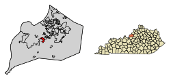 Location of Watterson Park in Jefferson County, Kentucky | |
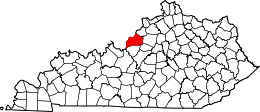
 Watterson Park Location within the state of Kentucky  Watterson Park Watterson Park (the US) | |
| Coordinates: 38°11′41″N 85°41′22″W / 38.19472°N 85.68944°WCoordinates: 38°11′41″N 85°41′22″W / 38.19472°N 85.68944°W | |
| Country | United States |
| State | Kentucky |
| County | Jefferson |
| Area | |
| • Total | 1.43 sq mi (3.71 km2) |
| • Land | 1.43 sq mi (3.70 km2) |
| • Water | 0.004 sq mi (0.01 km2) |
| Elevation | 476 ft (145 m) |
| Population (2010) | |
| • Total | 976 |
| • Estimate (2016)[1] | 1,005 |
| • Density | 682/sq mi (263.5/km2) |
| Time zone | UTC-5 (Eastern (EST)) |
| • Summer (DST) | UTC-4 (EDT) |
| ZIP Code | 40218 |
| FIPS code | 21-80913 |
| GNIS feature ID | 1669497 |
| Website |
wattersonparkky |
Watterson Park is a home rule-class city in Jefferson County, Kentucky, United States. The population was 976 at the 2010 census.[2]
Geography
Watterson Park is located in central Jefferson County at 38°11′41″N 85°41′22″W / 38.19472°N 85.68944°W (38.194819, -85.689506).[3] Interstate 264 runs just north of the city limits, while Newburg Road forms the northeast border and Poplar Level Road (Kentucky Route 864) forms parts of the southwest border. Downtown Louisville is 7 miles (11 km) to the northwest. Watterson Park is bordered to the east by West Buechel, and Poplar Hills touches a small length of the southwest boundary.
According to the United States Census Bureau, Watterson Park has a total area of 1.4 square miles (3.7 km2), of which 1.9 acres (7,888 m2), or 0.21%, are water.[2]
Demographics
| Historical population | |||
|---|---|---|---|
| Census | Pop. | %± | |
| 1990 | 1,542 | — | |
| 2000 | 953 | −38.2% | |
| 2010 | 976 | 2.4% | |
| Est. 2016 | 1,005 | [1] | 3.0% |
| U.S. Decennial Census[4] | |||
As of the census[5] of 2000, there were 953 people, 504 households, and 252 families residing in the city. The population density was 675.9 people per square mile (261.0/km²). There were 538 housing units at an average density of 381.6 per square mile (147.3/km²). The racial makeup of the city was 78.38% White, 16.68% African American, 0.42% Native American, 1.47% Asian, 0.42% from other races, and 2.62% from two or more races. Hispanic or Latino of any race were 0.63% of the population.
There were 504 households out of which 16.5% had children under the age of 18 living with them, 32.9% were married couples living together, 10.9% had a female householder with no husband present, and 50.0% were non-families. 44.0% of all households were made up of individuals and 17.7% had someone living alone who was 65 years of age or older. The average household size was 1.89 and the average family size was 2.55.
In the city, the population was spread out with 14.8% under the age of 18, 7.6% from 18 to 24, 32.4% from 25 to 44, 24.7% from 45 to 64, and 20.6% who were 65 years of age or older. The median age was 42 years. For every 100 females, there were 102.3 males. For every 100 females age 18 and over, there were 96.1 males.
The median income for a household in the city was $25,417, and the median income for a family was $34,917. Males had a median income of $30,500 versus $22,759 for females. The per capita income for the city was $18,933. About 7.5% of families and 14.0% of the population were below the poverty line, including 13.7% of those under age 18 and 9.7% of those age 65 or over.
References
- 1 2 "Population and Housing Unit Estimates". Retrieved June 9, 2017.
- 1 2 "Geographic Identifiers: 2010 Census Summary File 1 (G001): Watterson Park city, Kentucky". American Factfinder. U.S. Census Bureau. Retrieved June 22, 2018.
- ↑ "US Gazetteer files: 2010, 2000, and 1990". United States Census Bureau. 2011-02-12. Retrieved 2011-04-23.
- ↑ "Census of Population and Housing". Census.gov. Retrieved June 4, 2015.
- ↑ "American FactFinder". United States Census Bureau. Retrieved 2008-01-31.
External links
| History |
|  |
|---|---|---|
| Geography |
| |
| Government |
| |
| Transportation | ||
| Other subject areas | ||
| Top subjects | ||
| National Historic Landmarks | ||
| Prominent suburbs (over 10K pop.) | ||
| ||