Harrison County, Indiana
| Harrison County, Indiana | |
|---|---|
 Harrison County courthouse in Corydon, built in 1928 | |
 Location in the U.S. state of Indiana | |
 Indiana's location in the U.S. | |
| Founded | 1 December, 1808 |
| Named for | William Henry Harrison |
| Seat | Corydon |
| Largest city | Corydon |
| Area | |
| • Total | 486.52 sq mi (1,260 km2) |
| • Land | 484.52 sq mi (1,255 km2) |
| • Water | 2.00 sq mi (5 km2), 0.41% |
| Population | |
| • (2010) | 39,364 |
| • Density | 81.2/sq mi (31.4/km2) |
| Congressional district | 9th |
| Time zone | Eastern: UTC−5/−4 |
Harrison County is located in the far southern part of the U.S. state of Indiana along the Ohio River. The county was officially established in 1808. As of the 2010 census, the county's population was 39,364, an increase of 6.6% from 2000.[1] The county seat is Corydon, the former capital of Indiana.[2]
Harrison County is part of the Louisville-Jefferson County, KY-IN Metropolitan Statistical Area.
The county has a diverse economy with no sector employing more than 13% of the local workforce. Horseshoe Southern Indiana is the largest employer, followed by Tyson Foods and the Harrison County Hospital. Tourism plays a significant role in the economy and is centered on the county's many historic sites. County government is divided among several bodies including the boards of the county's three school districts, three elected commissioners who exercise legislative and executive powers, an elected county council that controls the county budget, a circuit and superior court, and township trustees in the county's 12 townships. The county has 10 incorporated towns with a total population of over 5,000, as well as many small unincorporated towns. One Interstate highway and one U. S. Route run through the county, as do eight Indiana State Roads and two railroad lines.[3][4]
Migratory groups of Native Americans inhabited the area for thousands of years, but the first permanent settlements in what would become Harrison County were created by American settlers in the years after the American Revolutionary War. The population grew rapidly during first decade of the 19th century. Corydon was officially platted in 1808 and became the capital of the Indiana Territory in 1813. Many of the state's early important historic events occurred in the county, including the writing of Indiana's first constitution. Corydon was the state capital until 1825, but in the years afterward remained an important hub for southern Indiana. In 1859 there was a major meteorite strike.[5] In 1863 the Battle of Corydon was fought, the only battle of the American Civil War to occur in Indiana.[6]
History
Humans first entered what would become Indiana near the end of the last ice age. This region was of particular value to the early humans because of the abundance of flint. There is evidence of flint mining in local caves as early as 2000 BCE; the stone was used to produce crude tools. Passing migratory tribes frequented the area which was influenced by succeeding groups of peoples including the Hopewells and Mississippians.[7] One flint-working and camping location is the Swan's Landing Archeological Site, one of the most important Early Archaic archaeological sites in eastern North America.[8] Permanent human settlements in the county began with the arrival of American settlers in the last decade of the 18th century.[7]
The area became part of the United States following its conquest during the American Revolutionary War. Veterans of the revolution received land grants in the eastern part of the county as part of Clark's Grant. Daniel Boone and his brother Squire Boone were early explorers of the county, entering from Kentucky in the 1780s. Harvey Heth, Spier Spencer, and Edward Smith were among the first to settle in the county beginning in the 1790s. Smith built the first home in the area of Corydon.[9]
Harrison County was originally part of Knox County and Clark County but was separated in 1808. It was the first Indiana county formed by the Indiana territorial legislature instead of the Governor.[10] Portions of the county were later separated into parts of Crawford, Floyd, Washington, Jackson, Clark, Lawrence, Perry, Scott and Orange Counties.[11] The county was named for William Henry Harrison, the first governor of Indiana Territory, a General in War of 1812, hero of Tippecanoe, and the 9th U.S. President.[10] Harrison was the largest land holder in the county at the time and had a small estate at Harrison Spring.[12]
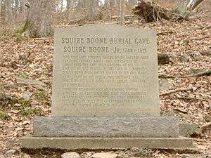
Squire Boone settled permanently in what is now Boone Township in 1806. He died in 1815 and is buried in a cave near his home, Squire Boone Caverns. James, Isaiah, and Daniel (son of Squire) Boone settled in Harrison County's Heth Township during the first decade of the 1800s.[13] The county's first church was built by Boone east of present-day Laconia.[9] The church, which has been reconstructed, is known as Old Goshen. Jacob Kintner settled near Corydon in about 1810. He was one of the wealthiest settlers and amassed a 700-acre (2.8 km2) tract of land around Corydon, built a large home, and maintained an inn.[14] Paul and Susanna Mitchem became Quakers and immigrated to Harrison County from North Carolina in 1814, bringing with them 107 slaves whom they freed after arriving. Although some of the former slaves left, the group became one of the largest communities of free blacks in the state.[15]
The first road was built in Harrison County in 1809 connecting Corydon with Mauckport on the Ohio River. A tow-and-ferry line was operated there by the Mauck family bringing settlers into the county from Kentucky. This road and ferry greatly expanded the county's economic viability and ease of access to the outside world, leading to a rapid settlement of the area. The county's population more than doubled in the following decade.[16]
Dennis Pennington, who lived near Lanesville, became one of the county's early leading citizens and speaker of the territory's legislature.[17] Corydon began competing with other southern Indiana settlements to become the new capital of the territory after its reorganization in 1809. Hostilities broke out in 1811 with the Native American tribes on the frontier, and the territorial capital was moved to Corydon on 1 May 1813, after Pennington suggested that it would be safer than Vincennes.[18] For the next twelve years, Corydon was the political center of the territory and subsequent state. A state constitution was drafted in Corydon during June 1816 and after statehood the town served as the state capital until 1825.[12]
The first division of the county occurred in 1814 when the northern portion of the county was separated to become Washington County. In 1818 with the western part of the county was partitioned off to become Crawford County.[19] In 1819 Floyd County was created out of the eastern part of the county.[20] Since that time, Harrison County's eastern border has had minor adjustments through land transactions with Floyd County; the last change occurred in 1968.
The northern part of the county is known as the barrens, named by the early settlers for its scarce timber. At first, settlers preferred the southern areas where wood was available.[21] The barrens were swept by annual wildfires that prevented the growth of trees. The largest barren ran from the northern edge of Corydon northward to Palmyra, and from the Floyd Knobs in the east, westward to the Blue River. The Central Barren covered most of the upper middle part of the county. As settlement expanded and farming grew in the early 19th century, settlers found the barrens to be fertile farmland, and they were quickly settled. As settlement increased, the wildfires were stopped and by the start of the 20th century the uninhabited parts of the barrens had become forested and have remained so until modern times.[22]
A large meteorite fell near Buena Vista on 28 March 1859. The impact site and a part of the meteorite have been preserved.[5]

The first Harrison County fair was held in Corydon in 1860; it has been an annual event since then and is the state's longest continuously running fair.[23] The county fairgrounds were built in Corydon on Edward Smith's former homesite. The original grandstand burned in 1960 and the county purchased a new grandstand from the minor league baseball team at Parkway Field in Louisville, Kentucky.[24]
The only Civil War battle fought in Indiana occurred in Harrison County on 9 July 1863, between the Harrison County Legion and a Confederate group under Brigadier General John Hunt Morgan, during Morgan's Raid.[6] Morgan crossed the Ohio River into Harrison County in the early hours of daylight, resisted by artillery fire from the Indiana shore and an armed river boat. Confederate artillery returned fire from the opposite shore, and the Legion retreated towards Corydon. The citizens of Mauckport fled the town carrying their valuables.[6] Morgan landed on the east side of Mauckport with two thousand cavalry and marched north burning homes, farms, and mills.[6] The county militia made a stand to block his advance on the county seat and the resulting conflict is known as the Battle of Corydon. The battle was won by the Confederates and the town of Corydon was then sacked and stores were looted and ransomed. The battle left 4 dead, 12 wounded, and 355 captured.[25] After the battle Morgan continued into northern Harrison County where he looted the New Salisbury area with the main body of troops. Crandall and Palmyra were robbed and sacked by detachments. His forces left the county the following day; they were eventually defeated and captured by Union Army forces.[25]

The railroad reached Harrison County in 1869. A line was completed across the northern half of county in 1874 running from Floyd County connecting Crandall and then continuing west into Crawford County.[26] A southward extension connecting Corydon to Crandall was completed in 1882. A train wreck killed three in 1902.[27] The southern extension connecting Corydon was purchased by the Corydon Scenic Railroad Company in 1989. It operated as a tourist attraction until its 2003 closing, which ended passenger service in the county.[28]
The first county courthouse was a small log building. When Corydon became the territory capital in 1813, county and territorial officials shared the building. By 1816 a stone building had been constructed, and it served as both Harrison County Courthouse and the state capital building until the capital was moved. As more space was needed, other buildings were constructed to supplement the courthouse. In the 1920s, the latest of these office buildings was razed to make way for a new courthouse; the old building was acquired by the State of Indiana and preserved as the first state capitol building. The new courthouse was built from 1927 to 1928 at a cost of about $250,000.[n 1] The building was designed by Fowler and Karges of Evansville and was constructed by J. Fred Beggs and Company of Scottsburg.[30][31]
The Harrison-Crawford State Forest was started in 1932 when the State of Indiana purchased land in western Harrison County. The 26,000-acre (110 km2) park is the largest state forest in Indiana and surrounds the O'Bannon Woods State Park and Wyandotte Caves, located in eastern Crawford County.
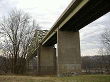
The Matthew E. Welsh Bridge was completed in 1966 in Mauckport, to connect Harrison County with neighboring Meade County in Kentucky. This is the only bridge over the Ohio River between Tell City and New Albany.[32] In 1969 Dr. Samuel P. Hays donated the 311-acre (1.26 km2) Hayswood Nature Reserve to the county. It was developed in 1973 by the Harrison County Park Board by adding public facilities to the western part of the preserve. It is the second largest nature reserve in the county.[33]
Caesars Indiana opened a casino river boat, hotel complex, and golf course in 1998, boosting the county's tourism industry. The casino complex was purchased and became Horseshoe Southern Indiana on 11 July 2008.[34]
Geography
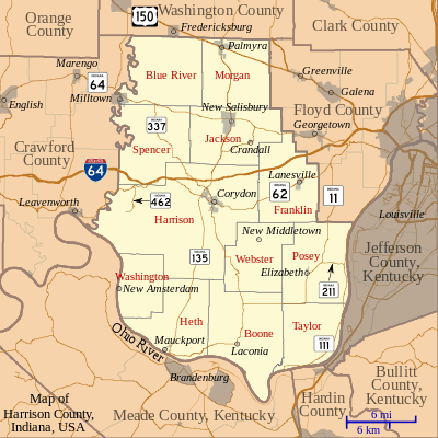
Harrison County is located in the far southern part of Indiana, about halfway between the state's east and west borders. The Ohio River defines the county's southern border; across the river lies the state of Kentucky and the city of Louisville. The Blue River runs along the county's western border. According to the 2010 census, the county has a total area of 486.52 square miles (1,260.1 km2), of which 484.52 square miles (1,254.9 km2) (or 99.59%) is land and 2.00 square miles (5.2 km2) (or 0.41%) is water.[35]
Harrison Spring is located west of Corydon; it is 60 feet (18 m) in diameter and is over 40 feet (12 m) deep, making it the largest and deepest spring in Indiana. It rises from a solid rock in a level spot of land, and it outputs enough water to have turned flour mills in the past. Is the largest spring by volume in Indiana producing over 3 million gallons (11 million liters) of water daily. The name recognizes William Henry Harrison, who owned this area.[36]
Harrison County is hilly in parts. The Knobstone Escarpment begins in the southeastern part of the county, rises sharply at the Ohio River, and runs along the eastern edge of the county. The "knobs" are the most significant series of hills in Indiana, with the highest knobs near the Ohio River towering 610 feet (190 m) over the surrounding valley.[37] This is the greatest local relief difference in the state.[38] The Ohio River borders the entire southeastern, southern, and southwestern part of the county. Blue River forms the western border with Indian Creek and Buck Creek as the primary internal drainage systems.
The western part of the county is preserved as the Harrison-Crawford State Forest and the O'Bannon Woods State Park. The county has extensive cave systems including Squire Boone Caverns, the Binkley Cave System (Indiana Caverns) and smaller, highly decorated caves such as Jewel Box and Devil's Graveyard caves.
Adjacent counties
- Crawford County (west)
- Floyd County (east)
- Hardin County, Kentucky (southeast)
- Jefferson County, Kentucky (southeast)
- Meade County, Kentucky (south)
- Washington County (north)
Towns and incorporated communities
Unincorporated communities
- Bradford
- Breckenridge
- Bridgeport
- Buena Vista
- Byrneville
- Central
- Central Barren
- Corydon Junction
- Davidson
- Depauw
- Dixie
- Dogwood
- Evans Landing
- Fairdale
- Fishtown
- Frenchtown
- Glidas
- Hancock Chapel
- Macedonia
- Moberly
- Mott
- New Boston
- New Salisbury (Census-designated place)
- Ramsey
- Rosewood
- Sugar Grove
- Titus
- Tobacco Landing
- Valley City
- White Cloud
Townships
Incorporated communities by population
| Town | Township | Population | Founded |
|---|---|---|---|
| Corydon | Harrison | 2,715 | 1808 |
| Crandall | Jackson | 131 | 1872 |
| Elizabeth | Posey | 137 | 1812 |
| Laconia | Boone | 29 | 1837 |
| Lanesville | Franklin | 614 | 1817 |
| Mauckport | Heth | 83 | 1827 |
| Milltown | Blue River | 932* | 1827 |
| New Amsterdam | Washington | 27 | 1815 |
| New Middletown | Webster | 77 | 1860 |
| Palmyra | Morgan | 930 | 1810 |
Climate and weather
| Corydon, Indiana | ||||||||||||||||||||||||||||||||||||||||||||||||||||||||||||
|---|---|---|---|---|---|---|---|---|---|---|---|---|---|---|---|---|---|---|---|---|---|---|---|---|---|---|---|---|---|---|---|---|---|---|---|---|---|---|---|---|---|---|---|---|---|---|---|---|---|---|---|---|---|---|---|---|---|---|---|---|
| Climate chart (explanation) | ||||||||||||||||||||||||||||||||||||||||||||||||||||||||||||
| ||||||||||||||||||||||||||||||||||||||||||||||||||||||||||||
| ||||||||||||||||||||||||||||||||||||||||||||||||||||||||||||
Harrison County is in the humid subtropical climate region of the United States along with most of Southern Indiana. Its Köppen climate classification is Dfa,[40] meaning that it is cold, has no dry season, and has a hot summer. However, it is close to the southern edge of this region.[41] In recent years, average temperatures in Corydon have ranged from a low of 21 °F (−6 °C) in January to a high of 88 °F (31 °C) in July, although a record low of −31 °F (−35 °C) was recorded in January 1977 and a record high of 104 °F (40 °C) was recorded in July 1983. Average monthly precipitation ranged from 3.13 inches (80 mm) in October to 5.06 inches (129 mm) in May.[39]
Government
The county government is a constitutional body and is granted specific powers by the Constitution of Indiana and by the Indiana Code. Executive and legislative power is vested in the Board of Commissioners, and fiscal power is vested in the County Council.[42]
The seven member county council is the fiscal branch of the county government and controls all the spending and revenue collection in the county. Four representatives are elected from county districts and three are elected at-large. The council members serve four-year terms. They are responsible for setting salaries, the annual budget, and special spending. The council has limited authority to impose local income, property, excise and service taxes. County income and property taxes are subject to state level approval.[42][43]
The Board of Commissioners consists of three commissioners who are elected county-wide in four–year staggered terms. One commissioner serves as president of the board. The commissioners manage the budget set forth by the council, the collection of revenue, enact and repeal ordinances, and managing the day-to-day functions of the county government. The commissioners meet twice monthly.[42][43]
Harrison County has a Circuit Court and a Superior Court. The Superior Court handles adult criminal cases, small claims cases, traffic tickets, and infractions. The Circuit Court handles the rest of the cases in the county, including most of the divorce cases, juvenile matters, CHINS cases, civil proceedings, probate, estates, adoptions and civil commitments. Judges in each court serve a six-year term. The Judge of the Circuit Court appoints a referee to handle family law cases.[43]
The county has several other elected offices, including sheriff, coroner, auditor, treasurer, recorder, surveyor and circuit court clerk. Each serves a four–year term. Members elected to county government positions are required to declare party affiliations and to be residents of the county.[43]
Each township has a trustee who administers rural fire protection and ambulance service, provides poor relief and manages cemetery care, among other duties. The trustee is assisted in these duties by a three-member township board. The trustees and board members are elected to four-year terms.[44]
Most of Harrison County lies in State House District 70.[45] Blue River Township is part of State House District 73. The entire county is part of State Senate District 47.[46] The county is part of Indiana's 9th congressional district.
| Year | Republican | Democratic | Third parties |
|---|---|---|---|
| 2016 | 69.7% 12,943 | 25.8% 4,783 | 4.5% 832 |
| 2012 | 60.2% 10,640 | 37.4% 6,607 | 2.4% 424 |
| 2008 | 58.1% 10,551 | 40.1% 7,288 | 1.8% 335 |
| 2004 | 63.6% 11,015 | 35.7% 6,171 | 0.7% 124 |
| 2000 | 58.5% 8,711 | 39.4% 5,870 | 2.1% 315 |
| 1996 | 43.7% 6,073 | 42.5% 5,900 | 13.8% 1,912 |
| 1992 | 39.5% 5,403 | 42.2% 5,768 | 18.3% 2,500 |
| 1988 | 57.5% 6,702 | 42.3% 4,933 | 0.2% 26 |
| 1984 | 60.6% 7,255 | 38.7% 4,634 | 0.7% 80 |
| 1980 | 54.2% 6,287 | 42.0% 4,865 | 3.8% 442 |
| 1976 | 45.9% 4,911 | 53.1% 5,685 | 1.0% 103 |
| 1972 | 59.8% 5,910 | 39.7% 3,927 | 0.5% 51 |
| 1968 | 45.3% 4,410 | 38.3% 3,725 | 16.4% 1,596 |
| 1964 | 37.8% 3,671 | 61.3% 5,949 | 0.9% 88 |
| 1960 | 53.8% 5,374 | 45.7% 4,566 | 0.5% 49 |
| 1956 | 54.9% 5,299 | 44.2% 4,266 | 0.9% 83 |
| 1952 | 53.6% 5,069 | 44.6% 4,213 | 1.8% 172 |
| 1948 | 46.9% 4,104 | 51.0% 4,465 | 2.1% 182 |
| 1944 | 50.1% 4,397 | 48.8% 4,285 | 1.2% 104 |
| 1940 | 49.3% 4,650 | 50.1% 4,725 | 0.7% 64 |
| 1936 | 43.2% 3,885 | 55.9% 5,025 | 0.9% 76 |
| 1932 | 40.4% 3,553 | 58.3% 5,128 | 1.4% 123 |
| 1928 | 54.4% 4,440 | 44.9% 3,664 | 0.7% 54 |
| 1924 | 48.3% 3,896 | 49.7% 4,005 | 2.0% 163 |
| 1920 | 51.5% 4,271 | 47.0% 3,898 | 1.6% 132 |
| 1916 | 45.0% 2,086 | 51.2% 2,373 | 3.9% 180 |
| 1912 | 20.2% 900 | 47.3% 2,106 | 32.4% 1,443 |
| 1908 | 46.2% 2,419 | 50.5% 2,646 | 3.3% 174 |
| 1904 | 48.1% 2,544 | 47.8% 2,530 | 4.1% 216 |
| 1900 | 45.9% 2,482 | 52.3% 2,824 | 1.8% 99 |
| 1896 | 46.5% 2,486 | 52.6% 2,813 | 0.9% 50 |
| 1892 | 43.8% 2,114 | 51.0% 2,464 | 5.3% 254 |
| 1888 | 44.8% 2,133 | 53.1% 2,529 | 2.2% 103 |
Demographics
| Historical population | |||
|---|---|---|---|
| Census | Pop. | %± | |
| 1810 | 3,595 | — | |
| 1820 | 7,875 | 119.1% | |
| 1830 | 10,273 | 30.5% | |
| 1840 | 12,459 | 21.3% | |
| 1850 | 15,286 | 22.7% | |
| 1860 | 18,521 | 21.2% | |
| 1870 | 19,913 | 7.5% | |
| 1880 | 21,326 | 7.1% | |
| 1890 | 20,786 | −2.5% | |
| 1900 | 21,702 | 4.4% | |
| 1910 | 20,232 | −6.8% | |
| 1920 | 18,656 | −7.8% | |
| 1930 | 17,254 | −7.5% | |
| 1940 | 17,106 | −0.9% | |
| 1950 | 17,858 | 4.4% | |
| 1960 | 19,207 | 7.6% | |
| 1970 | 20,423 | 6.3% | |
| 1980 | 27,276 | 33.6% | |
| 1990 | 29,890 | 9.6% | |
| 2000 | 34,325 | 14.8% | |
| 2010 | 39,364 | 14.7% | |
| Est. 2016 | 39,826 | <ref">"Population and Housing Unit Estimates". Retrieved 9 June 2017. </ref> | 1.2% |
| U.S. Decennial Census[48] 1790-1960[49] 1900-1990[50] 1990-2000[51] 2010-2013[1] | |||
As of the 2010 United States Census, there were 39,364 people, 15,192 households, and 11,031 families residing in the county.[52] The population density was 81.2 inhabitants per square mile (31.4/km2). There were 16,534 housing units at an average density of 34.1 per square mile (13.2/km2).[35] The racial makeup of the county was 97.4% white, 0.5% black or African American, 0.4% Asian, 0.2% American Indian, 0.5% from other races, and 1.0% from two or more races. Those of Hispanic or Latino origin made up 1.5% of the population.[52] In terms of ancestry, 31.1% were German, 16.5% were American, 12.8% were Irish, and 12.8% were English.[53]
Of the 15,192 households, 33.7% had children under the age of 18 living with them, 58.5% were married couples living together, 9.5% had a female householder with no husband present, 27.4% were non-families, and 22.8% of all households were made up of individuals. The average household size was 2.56 and the average family size was 2.99. The median age was 40.2 years.[52]
The median income for a household in the county was $47,697 and the median income for a family was $59,316. Males had a median income of $40,884 versus $31,808 for females. The per capita income for the county was $23,539. About 7.8% of families and 10.0% of the population were below the poverty line, including 15.7% of those under age 18 and 5.1% of those age 65 or over.[54]
Economy

Harrison County has a diverse economy. Manufacturing industry is centered in the Corydon Industrial Park where automobile-related manufacturing is most prevalent.[55] There is large–scale farming throughout the rural areas of the county; corn and soybeans are the county's largest crops.[55] A service and shopping district is centered in Corydon. There are several medical facilities in the county including the Harrison County Hospital, two nursing facilities operated by Kindred Healthcare, and a number of private practices.[55]
The county has a developed tourism industry. The main attractions are the historic sites of Corydon, the county's golf courses, the Horseshoe Riverboat Casino and Hotel, and the area's two famous caves: Squire Boone Caverns near Mauckport and Wyandotte Caves in adjoining Crawford County. The casino is the county's single largest source of tax revenue and produced $23.5 million in tax revenue during 2007.[56]
Multiple utility companies serve the county. Electricity is provided by the Harrison Rural Electric Membership Cooperative (REMC) and Duke Energy. Natural gas is provided by the Indiana Utilities Corporation in Corydon and several small distributors provide rural service. Land-line telephone service is provided exclusively by Verizon. Cable television is provided by Insight Communications in some parts of the county. Water is pumped from a number of corporations, the largest being South Harrison Water Corporation and Ramsey Water Inc.[55]
As of July 2009, the county's largest employer was the Horseshoe Southern Indiana casino with 1,600 employees. Other large employers: Tyson Foods employs 550, Harrison County Hospital employs 504, South Harrison Community School Corporation employs 425, Blue River Services employs 405, Wal-Mart employs 400, North Harrison Community School Corporation employs 311, ICON Metal Forming employs 200, Darmic Inc. employs 120, Kindred Healthcare employs 115, Smith Store Fixtures and Lucas Oil Products each employs 80, Norstam Veneers employs 50, and Speed Flex employs 41. An additional 92 businesses employ 5 to 40 workers. 13% of the workforce is in retail, 12% in government, 12% in manufacturing, 11% in services, 8% in accommodations and food services, 8% in agriculture, 7% in construction, 7% working for local utilities, 6% in finance, insurance, and real estate, and 6% in other trades.[57] The Louisville, Jefferson County, KY-IN Metropolitan statistical area to which Harrison County belongs had an unemployment rate of 10.2% in December 2009.[58]
Transportation
Highways
- Interstate 64 runs east–west through Harrison County, connecting Corydon and Lanesville.[59]
- US Route 150 crosses the northern part of the county following the route of the Buffalo Trace.[60]
- State Road 135 runs north–south through the county.[61]
- State Road 62 runs east–west through the county, crossing State Road 135 at Corydon.[62]
- State Road 64 runs east–west across northern Harrison County. It crosses State Road 135 in New Salisbury.[63]
- State Road 111 connects Elizabeth with New Albany in neighboring Floyd County; the Horseshoe Riverboat Casino is located on the route.[64]
- State Road 337 runs northwest–southeast across the county, passing through Corydon.[65]
- State Road 211 runs for about 2 miles (3.2 km) east of Elizabeth in the southeast part of county, connecting State Roads 11 and 111.[66]
- State Road 462 connects the Harrison-Crawford State Forest with State Road 62 in the southwest part of the county, running for about 3 miles (4.8 km).[67]
Railroads
- Lucas Oil Rail Line m– a 7-mile (11 km) shortline railroad from Corydon northward through the industrial park where Lucas Oil's bottling facilities are located, to its intersection with east–west Norfolk Southern Railway line near New Salisbury.
- Norfolk Southern line - crosses northern Harrison County, through Crandall, Ramsey, and Depauw. It has a small depot in Ramsey.[4][55]
Education
The county has 22 schools; 15 are public schools in 3 school districts, and 7 are private.[68] South Harrison Community Schools is the largest district with 3,141 pupils in 2010. The district covers the southern half of the county and includes Corydon Central High School, Corydon Central Junior High School, South Central Junior & Senior High School, Corydon Intermediate, Corydon Elementary, Heth-Washington Elementary, and New Middletown Elementary.[69] North Harrison Community School Corporation had 2,324 pupils in 2010 enrolled in North Harrison High School, North Harrison Middle School, North Harrison Elementary, and Morgan Elementary.[70] Lanesville Community School Corporation is the smallest district serving only Franklin Township. It consists of Lanesville Junior Senior High School and Lanesville Elementary.[71] In 2010, teachers in the North Harrison district averaged $50,800 in annual salary; South Harrison teachers averaged $48,500; Lanesville teachers averaged $51,500. North Harrison had a 2010 graduation rate of 81.5%; South Harrison 84.6%; Lanesville 91.5%. Lanesville and North Harrison students performed above average on 2010 statewide ISTEP+ tests, while South Harrison students performed below average.[68]
The county has several private schools supported by local churches. St. John's, a Lutheran school near Lanesville, has 77 pupils. St. Joseph's, a Catholic school in Corydon, has 87 pupils.[68] County high school students, including those in public, private, and home schools, may attend the vocational school C. A. Prosser school of Technology in neighboring Floyd County as part of their high school curriculum.[72]
The 2017 Lanesville Eagles’ baseball program captured the school’s first state title in any sport and the first state crown in Harrison County history by way of a 5-1 win over Rossville in the Class 1A final at Victory Field in Indianapolis.[73]
The county is served by the Harrison County Public Library system.[74] All county residents have free access.[75]
Notable people

William Taylor Zenor - born in 1846 near Corydon. Practiced law in Corydon and Leavenworth. Judge, third judicial circuit (1885–1897). Indiana representative in US House of Representatives (1897 - 1907). Buried in Corydon.
James Best – born in 1926 in Kentucky; at the age of three he went to an orphanage, then was adopted and was raised in Corydon. After his Army service he became a movie and television actor. Best known as Sheriff Rosco P. Coltrane on The Dukes of Hazzard.[76]
Arville Funk - born in Harrison County in 1929 and attended school in Corydon. He taught high school history for 10 years starting in 1955. Practiced law in Corydon. He was active with Indiana historical and genealogical societies, and wrote about Indiana history. He is buried in Corydon.[77]
Frank O'Bannon – born in 1930 in Corydon. After an Air Force stint he was state senator, lieutenant governor, and then governor (1997–2003). Buried in Corydon.[78]
See also
Notes
References
- 1 2 3 "Harrison County QuickFacts". US Census Bureau. Archived from the original on 11 July 2011. Retrieved 20 September 2011.
- ↑ "Find a County – Harrison County IN". National Association of Counties. Retrieved 21 January 2012.
- ↑ "Indiana Transportation Map 2009–2010" (PDF). Indiana Department of Transportation. 2009. Retrieved 16 December 2010.
- 1 2 "State of Indiana 2011 Rail System Map" (PDF). Indiana Department of Transportation. 2011. Retrieved 19 June 2011.
- 1 2 Crayden 1959, p. 3.
- 1 2 3 4 Funk 1969, p. 86.
- 1 2 Dick 2000, p. 7.
- ↑ Smith, Edward E., Jr. "The Swan's Landing Site (12Hr304): An Early Archaic (Kirk Horizon) Site in Harrison County, South-Central Indiana". Midcontinental Journal of Archaeology 20.2 (1995): 192–238. 213.
- 1 2 Dick 2000, p. 8.
- 1 2 Funk 1969, p. 118.
- ↑ Roose 1911, p. 122.
- 1 2 Goodrich 1875, p. 560.
- ↑ Crayden 1959, p. 6.
- ↑ Dick 2000, p. 10.
- ↑ Dick 2000, p. 34.
- ↑ Crayden 1959, p. 7.
- ↑ Dick 2000, p. 12.
- ↑ Dick 2000, p. 16.
- ↑ Roose 1911, p. 124.
- ↑ Roose 1911, p. 129.
- ↑ Roose 1911, p. 16.
- ↑ Roose 1911, pp. 17–18.
- ↑ Crayden 1959, p. 1.
- ↑ Dick 2000, p. 38.
- 1 2 Funk 1969, p. 87.
- ↑ Crayden 1959, p. 11.
- ↑ Crayden 1959, p. 12.
- ↑ Longest 2005, p. 91.
- ↑ Williamson, Samuel H. (2011). Seven Ways to Compute the Relative Value of a U.S. Dollar Amount, 1774 to present. MeasuringWorth.
- ↑ Counts, Will; Jon Dilts (1991). The 92 Magnificent Indiana Courthouses. Bloomington, Indiana: Indiana University Press. pp. 68–69. ISBN 978-0-253-33638-5.
- ↑ Dick 2000, p. 15.
- ↑ Gugin 2006, p. 339.
- ↑ "Hayswood Nature Reserve". Harrison County Park and Recreation Department. Retrieved 3 February 2010.
- ↑ Harrison County Chamber of Commerce, p. 21.
- 1 2 "Population, Housing Units, Area, and Density: 2010 - County". US Census Bureau. Retrieved 10 July 2015.
- ↑ Roose 1911, p. 23.
- ↑ Logan 1922, p. 90.
- ↑ Logan 1922, p. 91.
- 1 2 "Monthly Averages for Corydon IN". The Weather Channel. Retrieved 27 January 2011.
- ↑ "Köppen Climate Classification for the Conterminous United States". Idaho State Climate Services. Archived from the original on 30 September 2009. Retrieved 23 January 2011.
- ↑ Peel, M. C.; Finlayson, B. L.; McMahon, T. A. (2007). "Updated world map of the Köppen-Geiger climate classification" (PDF). Copernicus Publications. p. 1636. Retrieved 23 January 2011.
- 1 2 3 Indiana Code. "Title 36, Article 2, Section 3". IN.gov. Retrieved 16 September 2008.
- 1 2 3 4 Indiana Code. "Title 2, Article 10, Section 2" (PDF). IN.gov. Retrieved 16 September 2008.
- ↑ "Government". United Township Association of Indiana. Retrieved 20 January 2012.
- ↑ "Indiana House Districts". State of Indiana. Retrieved 14 July 2011.
- ↑ "Indiana Senate Districts". State of Indiana. Retrieved 14 July 2011.
- ↑ Leip, David. "Dave Leip's Atlas of U.S. Presidential Elections". uselectionatlas.org. Retrieved 17 May 2018.
- ↑ "US Decennial Census". US Census Bureau. Retrieved 10 July 2014.
- ↑ "Historical Census Browser". University of Virginia Library. Retrieved 10 July 2014.
- ↑ "Population of Counties by Decennial Census: 1900 to 1990". US Census Bureau. Retrieved 10 July 2014.
- ↑ "Census 2000 PHC-T-4. Ranking Tables for Counties: 1990 and 2000" (PDF). US Census Bureau. Retrieved 10 July 2014.
- 1 2 3 "Profile of General Population and Housing Characteristics: 2010 Demographic Profile Data". US Census Bureau. Retrieved 10 July 2015.
- ↑ "Selected Social Characteristics in the United States – 2006-2010 American Community Survey 5-Year Estimates". US Census Bureau. Retrieved 10 July 2015.
- ↑ "Selected Economic Characteristics – 2006-2010 American Community Survey 5-Year Estimates". US Census Bureau. Retrieved 10 July 2015.
- 1 2 3 4 5 Harrison County Chamber of Commerce, p. 18.
- ↑ Harrison County Chamber of Commerce, p. 22.
- ↑ Harrison County Chamber of Commerce, p. 19.
- ↑ "Louisville-Jefferson County, KY-IN Employment Data". United States Department of Labor. Retrieved 17 February 2010.
- ↑ "Interstate 64". Highway Explorer. Retrieved 21 January 2012.
- ↑ "US Route 150". Highway Explorer. Archived from the original on 5 June 2010. Retrieved 21 February 2012.
- ↑ "State Road 135". Highway Explorer. Retrieved 21 January 2012.
- ↑ "State Road 62". Highway Explorer. Retrieved 21 January 2012.
- ↑ "State Road 64". Highway Explorer. Retrieved 21 January 2012.
- ↑ "State Road 111". Highway Explorer. Retrieved 21 January 2012.
- ↑ "State Road 337". Highway Explorer. Retrieved 21 January 2012.
- ↑ "State Road 211". Highway Explorer. Retrieved 21 January 2012.
- ↑ "State Road 462". Highway Explorer. Retrieved 21 January 2012.
- 1 2 3 "Harrison County Schools". Indiana Department of Education. Archived from the original on 3 March 2010. Retrieved 16 February 2010.
- ↑ "South Harrison Community Schools". Indiana Department of Education. Retrieved 16 February 2010.
- ↑ "North Harrison Community Schools". Indiana Department of Education. Retrieved 16 February 2010.
- ↑ "Lanesville Community Schools". Indiana Department of Education. Retrieved 16 February 2010.
- ↑ "Participating Schools". C. A. Prosser School of Technology. Retrieved 16 February 2010.
- ↑ "Lanesville baseball wins school's first state championship". courier-journal.com. Retrieved 19 June 2017.
- ↑ "Indiana public library directory" (PDF). Indiana State Library. Retrieved 7 March 2018.
- ↑ "Frequently asked questions". Harrison County Public Library. Retrieved 7 March 2018.
- ↑ "Bio for James Best". Archived from the original on 9 October 2012. Retrieved 21 January 2012.
- ↑ Thompson, Donald E., ed. (1974). Indiana Authors and their Books, 1917–1966. Crawfordsville, Indiana: Wabash College. p. 225.
- ↑ "Indiana Governor Frank O'Bannon (1930-2003)". Indiana Historical Bureau. Retrieved 21 January 2012.
Further reading
- Crayden, Helen Ballard (1959). Centennial Fair Program. Harrison County Historical Society.
- Dick, Otis Amanda (2000). Corydon:Images of America. Arcadia Publishing. ISBN 0-7385-6050-2.
- Funk, Arville (1969). A Sketchbook of Indiana History (Revised 1983 ed.). Rochester, Indiana: Christian Book Press.
- Goodrich, De Witt Clinton; Richard, Charles Tuttle (1875). An Illustrated History of the State of Indiana. Indiana: R. S. Peale and Company.
- Gugin, Linda C.; St. Clair, James E, eds. (2006). The Governors of Indiana. Indianapolis, Indiana: Indiana Historical Society Press. ISBN 0-87195-196-7.
- Logan, W. N. (1922). Handbook of Indiana Geology. Indiana Department of Conservation.
- Longest, David E. (2005). Railroad Depots of Southern Indiana. Arcadia Publishing. ISBN 0-7385-3958-9.
- Roose, William H. (1911). Indiana's birthplace: a history of Harrison County, Indiana. Tribune Company Printers.
External links
| Wikimedia Commons has media related to Harrison County, Indiana. |
- Official Harrison County Website
- Harrison County Tourism Website
- Registered Harrison County Historic Sites
- Indiana Department of Education, Harrison County Schools
- Watchful Eye of Harrison County
Places adjacent to Harrison County, Indiana | ||||||||||
|---|---|---|---|---|---|---|---|---|---|---|
| ||||||||||
Municipalities and communities of Harrison County, Indiana, United States | ||
|---|---|---|
| Towns | ||
| Townships | ||
| CDP | ||
| Other unincorporated communities |
| |
| Ghost town | ||
| Footnotes | ‡This populated place also has portions in an adjacent county or counties | |
