Treaty of Greenville
.jpg)
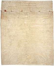
The Treaty of Greenville may refer to one or two treaties at Fort Greenville, now Greenville, Ohio. The first was signed on August 3, 1795, following the Native American loss at the Battle of Fallen Timbers a year earlier. It ended the Northwest Indian War in the Ohio Country, limited Indian Country to strategic parcels of land to the north and west, and began the practice of annual payments following land concessions. The parties to the first treaty were a coalition of Native American tribes known as the Western Confederacy, and United States government represented by General Anthony Wayne and local frontiersmen. Some consider this first treaty "the beginning of modern Ohio history."[1] After the War of 1812, a second treaty was signed at the Fort, which made further land concessions (See Treaty of Greenville (1814)) and would, following another two decades and the Black Hawk War, lead to termination of Indian County east of the Mississippi River in the Treaty of Chicago.
Participants
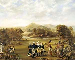
General "Mad Anthony" Wayne, who led the victory at Fallen Timbers, led the American delegation in the 1795 negotiations. Other members included William Wells, William Henry Harrison (who would become Indiana's governor and the key negotiator during the second treaty, and still later the 9th President of the United States), William Clark, Caleb Swan, and Meriwether Lewis.[2]
Native American leaders who signed the first treaty included leaders of these bands and tribes: Wyandot chiefs Tarhe, Leatherlips, and Roundhead (Wyandot), Delaware (Lenape; several bands). Shawnee (Chief Blue Jacket), Ottawa (several bands), Chippewa, Potawatomi (23 signatories, including Gomo, Siggenauk, Black Partridge, Topinabee and Five Medals), Miami (several bands, including Chief Little Turtle of the Miami-Illinois band), Wea, Kickapoo, and Kaskaskia.[3]
After the negotiations, Little Turtle and William Wells twice traveled Philadelphia (then the U.S. capital) and later to Washington, D.C. (including with other chiefs) to secure American support for the treaty from Presidents George Washington, John Adams and Thomas Jefferson.[4] Wells became deputy Indian agent in the Northwest Territory and would eventually make Fort Wayne his base (and die in 1812 escorting troops and civilians from Fort Dearborn in what became known as the Fort Dearborn massacre shortly after the start of the War of 1812). Years later, Clark again met one of the Delaware chiefs from the conference, as he noted in his journal for December 23, 1803: "a raney [sic] day… several Deleaway pass, a chief whome I saw at Greenville Treaty, I gave him a bottle of whiskey."[5] Harrison would become Governor of the Indiana Territory after creation of the state of Ohio (and later Governor of Indiana and a General himself), and demand further concessions between 1803 and 1809. However, those would lead to a generational divide within the tribes, as younger leaders including Main Poc, Siggenauk and Chebanse were excluded from the negotiations and instead developed links with Tecumseh, as well as raided or attached growing U.S. settlements including Vincennes, Kaskaskia, Fort Dearborn and Fort Wayne by 1812.[6]
Land for annuity
The first treaty established what became known as the Greenville Treaty Line delineated below. For several years it distinguished Native American territory from lands open to European-American settlers, although settlers continued to encroach, hence the hostilities which led to the second treaty. In exchange for goods to the value of $20,000 (such as blankets, utensils, and domestic animals), the Native American tribes ceded to the United States large parts of modern-day Ohio. The treaty also permitted U.S. Army posts within the Indian Country established to the north and west of the ceded lands, the most important of which was the future site of Fort Dearborn (later, downtown Chicago) on Lake Michigan,[nb 1][8] Other American lands within Indian County included Fort Detroit, Fort Vincennes, Ouiatenon, Fort Wayne,[9] Fort Miami,[10] and Fort Stephenson.[11]
The first Greenville treaty also established the "annuity" system of payment in return for Native American cessions of land east of the treaty line: yearly grants of federal money and supplies of calico cloth to Native American tribes. This institutionalized continuing government influence in tribal affairs and gave outsiders considerable control over Native American life.[12]
Nearly twenty years later, on July 22, 1814 now General William Henry Harrison and Governor Lewis Cass held a second treaty signing at Fort Greenville, this time with leaders of the Wyandot, Delaware, Shawnee, Seneca, Miami and Potawatomi tribes.[13] That treaty helped ended hostilities with these tribes and solidified US loyalties during the War of 1812 with Great Britain.
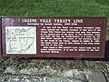
Treaty line route
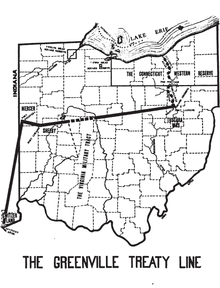
The treaty line began at the mouth of the Cuyahoga River in present-day Cleveland and ran south along the river to the portage between the Cuyahoga and Tuscarawas rivers, in what is now known as the Portage Lakes area between Akron and Canton. The line continued down the Tuscarawas to Fort Laurens near present-day Bolivar.
From there, the line ran west-southwest to near present-day Fort Loramie on a branch of the Great Miami River. From there, the line ran west-northwest to Fort Recovery, on the Wabash River near the present-day boundary between Ohio and Indiana. From Fort Recovery, the line ran south-southwest to the Ohio River at a point opposite the mouth of the Kentucky River in present-day Carrollton, Kentucky.
Depictions
A painting commemorating the treaty hangs in the Ohio Statehouse. It was completed by Ohio artist Howard Chandler Christy. At 23 feet wide, it is the largest painting in the Ohio Statehouse.[14]
Gallery


Notes
References
- ↑ "Capitol Ohio : 113 - Treaty of Greenville". The Ohio Statehouse. Retrieved 2015-09-13.
- ↑ "Capitol Ohio : 113 - Treaty of Greenville". The Ohio Statehouse. Retrieved 2015-09-13.
- ↑ "Capitol Ohio : 113 - Treaty of Greenville". The Ohio Statehouse. Retrieved 2015-09-13.
- ↑ Keating pp. 40, 52
- ↑ G. Moulton, ed. The Journals of the Lewis and Clark Expedition. Vol. 2, p. 140.
- ↑ Keating pp. 86, 192
- ↑ Charles J. Kappler (1904). "TREATY WITH THE WYANDOT, ETC., 1795". U.S. Government treaties with American Indian tribes. Oklahoma State University Library. Retrieved 1 August 2009.
- ↑ "Fort Dearborn" in online Encyclopedia of Chicago accessed 2009-08-01
- ↑ Ann Durkin Keating, Rising Up from Indian County: the battle of Fort Dearborn and the Birth of Chicago (University of Chicago Press 2012) p. 40 ISBN 9780226428963
- ↑ see Article 3 #8
- ↑ see Article 3 #11
- ↑ Eric Foner, Give Me Liberty (no page cite to a general U.S. History book??)
- ↑
- ↑ "Capitol Ohio : 113 - Treaty of Greenville". The Ohio Statehouse. Retrieved 2015-09-13.
External links
| Wikisource has original text related to this article: |
| Wikimedia Commons has media related to Treaty of Greenville. |