Pig, Kentucky
| Pig, Kentucky | |
|---|---|
| Unincorporated community | |
 Pig Location within the state of Kentucky  Pig Pig (the US) | |
| Coordinates: 37°7′58″N 86°10′12″W / 37.13278°N 86.17000°WCoordinates: 37°7′58″N 86°10′12″W / 37.13278°N 86.17000°W | |
| Country | United States |
| State | Kentucky |
| County | Edmonson |
| Elevation | 738 ft (225 m) |
| Time zone | UTC-6 (Central (CST)) |
| • Summer (DST) | UTC-5 (CST) |
| GNIS feature ID | 508818[1] |
Pig is an unincorporated community in southern Edmonson County, Kentucky, United States. Pig is generally referred to as the area near KY 422, stretching from the road's southern terminus at US 31-W, north along KY 259 towards Rhoda and KY 70 towards Brownsville.
The town was so named after disputes over which name to choose. A resident stated he saw a small hog on the road. The name of Pig was then accepted.[2]
It is part of the Bowling Green, Kentucky Metropolitan Statistical Area.
The Pig community is approximately 21.2 miles away from Bowling Green, which is in Warren County.
References
- ↑ U.S. Geological Survey Geographic Names Information System: Pig, Kentucky
- ↑ Rennick, Charles (1984). Kentucky Place Names. Lexington, KY: University Press of Kentucky. p. 233.
Municipalities and communities of Edmonson County, Kentucky, United States | ||
|---|---|---|
| City | 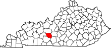 | |
| Unincorporated communities | ||
| Ghost town | ||
| Footnotes | ‡This populated place also has portions in an adjacent county or counties | |
This article is issued from
Wikipedia.
The text is licensed under Creative Commons - Attribution - Sharealike.
Additional terms may apply for the media files.