Barceloneta, Puerto Rico
Barceloneta (Spanish pronunciation: [baɾseloˈneta]) is a municipality in Puerto Rico and is located in the north region, bordering the Atlantic Ocean, north of Florida, east of Arecibo and west of Manati. Barceloneta is spread over 3 wards and Barceloneta Pueblo (the downtown area and the administrative center of the city). It is part of the San Juan-Caguas-Guaynabo Metropolitan Statistical Area.
Barceloneta Municipio de Barceloneta | |
|---|---|
Town and Municipality | |
 Barceloneta in letters sculpture | |
 Flag  Coat of arms | |
| Nicknames: "La Ciudad de las Piñas", "La Ciudad Industrial," "El Pueblo de los Indios", "El Pueblo de Sixto Escobar" | |
| Anthem: "Querido Barceloneta" | |
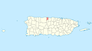 Location of Barceloneta in Puerto Rico | |
| Coordinates: 18°27′02″N 66°32′19″W | |
| Commonwealth | |
| Founded | July 1, 1881 |
| Government | |
| • Mayor | Wanda Soler (PPD) |
| • Senatorial dist. | 3 - Arecibo |
| • Representative dist. | 13 |
| Area | |
| • Total | 36.39 sq mi (94.24 km2) |
| • Land | 32 sq mi (82 km2) |
| • Water | 4.73 sq mi (12.24 km2) |
| Population (2010) | |
| • Total | 24,816 |
| • Density | 680/sq mi (260/km2) |
| Demonym(s) | Barcelonetences |
| Time zone | UTC−4 (AST) |
| Zip code | 00617 |
| Major routes | |
History
Barceloneta was founded on July 1, 1881 by Don Bonocio Llenza Feliú, an immigrant from Barcelona, Spain. The name of Barceloneta ("Little Barcelona") is derived from the Spanish city. Barceloneta was one of the last municipalities created by the Spanish Government in Puerto Rico.[1][2]
About a decade after its foundation, the town had a significant economic development led by agriculture and industry. By 1894, there were three sugarcane estates, 93 sugar mills, and the production of other fruits.[3]
In 1899, Barceloneta requested to be annexed to the town of Manatí. An election was scheduled for August 14, 1899 to decide the matter. However, on August 8, the island suffered the effects of Hurricane San Ciriaco, which prevented the elections from being held. The following year, Governor George Whitefield Davis ordered the annexation of Barceloneta into Manatí. The annexation was short-lived. Eleven years later, the government reinstated Barceloneta as a municipality.[4]
After Central Plazuela, a large sugar cane mill, closed in 1963, Barceloneta started reinforcing its agricultural economy with pineapples and other minor fruits. Efforts to revive the economy were not too successful, until pharmaceutical industries established themselves in the town during the 1970s.[5]
Because of its location next to the Río Grande de Manatí, Barceloneta was known for many years as a site of important port activity, for shipment of sugar and salt, as well as passengers to New York City and Barcelona. Don Bonocio's son was the owner of a sail ship that made those routes.
Geography
The Municipality of Barceloneta sits on the northern karst region of Puerto Rico, on the shores of the Atlantic Ocean. It is bordered by the municipalities of Arecibo, Florida, and Manatí. In terms of physical features, the municipality occupies a roughly rectangular area in the northern coast of the island. It has a surface area of 36.4 square miles (94.24 km2).[5]
Barceloneta's terrain is predominantly plain. Since it is located in the karst region, it features hills, ponors, and caves. Near the coast, the terrain is occupied by the Tiburones cienaga.[6]
Updated flood zone maps (as of 2019) show that Barceloneta is extremely vulnerable to flooding, along with Humacao, Rincón, Toa Baja, and Corozal. For its many wetlands, Barceloneta ends up being extremely vulnerable when hit by a major hurricane.[7]
Water features
The Río Grande de Manatí travels across the municipalities of Manatí and Barceloneta and drains into the Atlantic Ocean. Barceloneta also features the Caño Tiburones, a natural reserve.[5][6][8]
Barrios
Like all municipalities of Puerto Rico, Barceloneta is subdivided into barrios. The municipal buildings, central square and large Catholic church are located in a small barrio referred to as "el pueblo", near the center of the municipality.[9][10][11]
Sectors
Barrios (which are like minor civil divisions)[12] in turn are further subdivided into smaller local populated place areas/units called sectores (sectors in English). The types of sectores may vary, from normally sector to urbanización to reparto to barriada to residencial, among others.[13][14][15]
Special Communities
Of the 742 places on the list of Comunidades Especiales de Puerto Rico, the following barrios, communities, sectors, or neighborhoods are in Barceloneta: Abra del Pimiento, Abra los Caballos, Cité Sector in Garrochales, Palenque, and Seboruco.[16]
Tourism
Landmarks and places of interest
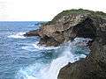
There are six beaches in Barceloneta including a black sand beach called Machuca.[17]
Barceloneta has many places of interest.[18]
- Antiguo Muelle (Old Seaport)
- Cambalache Reserve
- Caño Tiburones Marshland
- La Monserrate Refinery Ruins
- Las Criollas Beach
- Marqués de la Esperanza Hacienda Ruins
- Palmas Altas Beach
- Sixto Escobar Museum
- Centro Cultural de Barceloneta: Located in the heart of the city, the museum is dedicated to the culture and history of Barceloneta. Also features a collection of archaeological artifacts and Taino pieces.
Culture
Economy
Barceloneta has the biggest pharmaceutical complex in the world (14 industries). It is known that these companies have chosen Barceloneta to establish their facilities for its underground water reservoirs. The water in Barceloneta is so pure that it requires very little treatment for use in the manufacturing of pharmaceutical products.[5]
The employment created by these companies, along with a well-developed plan for urban growth, has allowed Barceloneta to be more than simply a town where people go to work. Puerto Rico Premium Outlets, conveniently placed near the expressway, have made the town into a favorite destination for shopping and consuming, and consequently a prime place for investment in food chains and entertainment. Increased employment opportunities have also caused an increase in population in Barceloneta and its surrounding municipalities. Barceloneta is looking at a future with tourism.
Barceloneta is also famous for its blue sand beaches, due to the high iron content found in the sand.
Demographics
The United States took control of Puerto Rico from Spain in the aftermath of the Spanish-American War under the terms of the Treaty of Paris of 1898 and conducted its first census of Puerto Rico, finding that the population of Barceloneta was 9,357.
| Historical population | |||
|---|---|---|---|
| Census | Pop. | %± | |
| 1900 | 9,357 | — | |
| 1910 | 11,644 | 24.4% | |
| 1920 | 13,442 | 15.4% | |
| 1930 | 15,751 | 17.2% | |
| 1940 | 18,545 | 17.7% | |
| 1950 | 19,897 | 7.3% | |
| 1960 | 19,334 | −2.8% | |
| 1970 | 20,792 | 7.5% | |
| 1980 | 18,942 | −8.9% | |
| 1990 | 20,947 | 10.6% | |
| 2000 | 22,322 | 6.6% | |
| 2010 | 24,816 | 11.2% | |
| U.S. Decennial Census[19] 1899 (shown as 1900)[20] 1910-1930[21] 1930-1950[22] 1960-2000[23] 2010[10] | |||
Government
Barceloneta is known for its political stability. Mayor Sol Luis Fontánes held the mayor's seat for the Popular Democratic Party (PPD) from 1986 until 2012. She assumed the role after the sudden death of elected mayor Héctor Ruíz Martínez, also of the PPD. After that, Fontánes was elected by only a narrow margin (49.2% vs. 48.6%), but he gained popularity with time. At the 2008 general elections, Fontánes received more than 70% of the votes and his margin of victory was one of the biggest of that election.[24][25] However, on 2012, Fontánes was arrested on charges of extortion, after 24 years as mayor. He resigned on March 1, 2012 while in prison.[26] In 2012, Wanda Soler was elected as Fontánes replacement.[18]
The Barceloneta Police Department is the municipality's police force.
The city belongs to the Puerto Rico Senatorial district III, which is represented by two Senators. In 2008, José Emilio González and Angel Martínez were elected as District Senators.[27]
Names and symbols
Flag
The flag of Barceloneta is a variation of the flag of Barcelona in Spain, from where the town borrows its name. It features four fields, two of them bearing the cross of Saint George (in Catalan, Sant Jordi), with five red and yellow bars in vertical direction to the right of each cross. These are all symbols pertaining to the city of Barcelona, and the community of Catalonia, where it is located, since the town was founded by a Catalan immigrant. The remaining two fields in the flag are blue, representing the Atlantic Ocean, which lies to the north of Barceloneta.[1][6][28]
Coat of arms
Barceloneta's coat of arms is similar to the flag, since it features the same Catalan symbols. However, it features three sugarcane flowers (guajanas) on top of the blue fields. The sugarcane flowers symbolize the source of life of the old agricultural economy of Barceloneta. The blue symbolizes the beaches and marine ports that contributed to the industry and commerce of the town. Like many coat of arms, it features a crown with three towers.[1]
Nicknames
Barceloneta is referred to as "La Ciudad de las Piñas" (city of the pineapples) for its many pineapple plantations. It is also known as "La Ciudad Industrial" (industrial city) for its many industries, mainly pharmaceutical.[29]
Other names are "Ciudad de los Indios" (town of the Indians) and "Pueblo de Sixto Escobar" (town of Sixto Escobar) for being the birthplace of the Puerto Rican boxer.
Education
Transportation
Barceloneta has recently added the use of trolly cars, free of charge, for local transport within the town itself. For travel outside Barceloneta, there is a station for carros publicos (public car transportation), which is a type of taxi.
There are 9 bridges in Barceloneta.[30]
Gallery
 Part of the Barceloneta coast
.jpg) City Hall in Barceloneta barrio-pueblo
City Hall in Barceloneta barrio-pueblo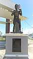 Statue of Sixto Escobar in Barceloneta
 Welcome to Barceloneta public art
 Thank you for visiting message on rock wall
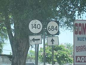 Signs for PR-140 and PR-684 in Barceloneta
References
- "Barceloneta Municipality Founding History and Symbols". enciclopediapr.org. Fundación Puertorriqueña de las Humanidades (FPH). Archived from the original on 14 February 2019. Retrieved 14 February 2019.
- "Barceloneta, Puerto Rico". Areciboweb.50megs.com. Archived from the original on 2011-10-20. Retrieved 2012-02-18.
- Barceloneta, Puerto Rico Archived 2012-03-25 at the Wayback Machine on BoricuaOnline
- Barceloneta, municipio de Puerto Rico Archived 2011-11-29 at the Wayback Machine on PRfogui
- "Barceloneta Municipality General Info (Location, Square Miles, Economy and Geography)". enciclopediapr. Fundación Puertorriqueña de las Humanidades (FPH). Archived from the original on 14 February 2019. Retrieved 14 February 2019.
- Barceloneta, Puerto Rico Archived 2012-03-25 at the Wayback Machine on BoricuaOnline.com
- Alvarado León, Gerardo E. "Sobre 250,000 estructuras están en zonas inundables" (PDF). Junta de Planificación - Gobierno de Puerto Rico (in Spanish). El Nuevo Día. Archived (PDF) from the original on 13 June 2019. Retrieved 3 July 2019.
- "Cinco datos curiosos sobre el caño Tiburones". El Nuevo Dia (in Spanish). 10 April 2014. Archived from the original on 12 May 2019. Retrieved 12 May 2019.
- Gwillim Law (20 May 2015). Administrative Subdivisions of Countries: A Comprehensive World Reference, 1900 through 1998. McFarland. p. 300. ISBN 978-1-4766-0447-3. Retrieved 25 December 2018.
- Puerto Rico:2010:population and housing unit counts.pdf (PDF). U.S. Dept. of Commerce, Economics and Statistics Administration, U.S. Census Bureau. 2010. Archived (PDF) from the original on 2017-02-20. Retrieved 2018-12-28.
- "Map of Barceloneta" (PDF). Archived (PDF) from the original on 2016-03-23. Retrieved 2007-12-17.
- "US Census Barrio-Pueblo definition". factfinder. US Census. Archived from the original on 13 May 2017. Retrieved 5 January 2019.
- "Agencia: Oficina del Coordinador General para el Financiamiento Socioeconómico y la Autogestión (Proposed 2016 Budget)". Puerto Rico Budgets (in Spanish). Retrieved 28 June 2019.
- Rivera Quintero, Marcia (2014), El vuelo de la esperanza: Proyecto de las Comunidades Especiales Puerto Rico, 1997-2004 (first ed.), San Juan, Puerto Rico Fundación Sila M. Calderón, ISBN 978-0-9820806-1-0
- "Leyes del 2001". Lex Juris Puerto Rico (in Spanish). Retrieved 24 June 2020.
- Rivera Quintero, Marcia (2014), El vuelo de la esperanza:Proyecto de las Comunidades Especiales Puerto Rico, 1997-2004 (Primera edición ed.), San Juan, Puerto Rico Fundación Sila M. Calderón, p. 273, ISBN 978-0-9820806-1-0
- "Las 1,200 playas de Puerto Rico [The 1200 beaches of Puerto Rico]". Primera Hora (in Spanish). April 14, 2017. Archived from the original on December 12, 2019. Retrieved December 12, 2019.
- "Barceloneta Municipality Festivals, Places, Mayor". enciclopediapr. Fundación Puertorriqueña de las Humanidades (FPH). Archived from the original on 14 February 2019. Retrieved 14 February 2019.
- "U.S. Decennial Census". United States Census Bureau. Archived from the original on February 13, 2020. Retrieved September 21, 2017.
- "Report of the Census of Porto Rico 1899". War Department Office Director Census of Porto Rico. Archived from the original on July 16, 2017. Retrieved September 21, 2017.
- "Table 3-Population of Municipalities: 1930 1920 and 1910" (PDF). United States Census Bureau. Archived (PDF) from the original on August 17, 2017. Retrieved September 21, 2017.
- "Table 4-Area and Population of Municipalities Urban and Rural: 1930 to 1950" (PDF). United States Census Bureau. Archived (PDF) from the original on August 30, 2015. Retrieved September 21, 2014.
- "Table 2 Population and Housing Units: 1960 to 2000" (PDF). United States Census Bureau. Archived (PDF) from the original on July 24, 2017. Retrieved September 21, 2017.
- Carmen Milagros Díaz (January 15, 2012). "Hablan los alcaldes invencibles". El Vocero. Archived from the original on March 1, 2012.
- "Elecciones en Puerto Rico". Electionspuertorico.org. Archived from the original on 2012-02-18. Retrieved 2012-02-18.
- Caquías Cruz, Sandra (March 1, 2012). "Sol Luis Fontanes renuncia a la alcaldía de Barceloneta". El Nuevo Día. Archived from the original on 2012-03-04. Retrieved 2012-03-03.
- Elecciones Generales 2008: Escrutinio General Archived November 20, 2011, at the Wayback Machine on CEEPUR
- Barceloneta, municipio de Puerto Rico Archived 2011-11-29 at the Wayback Machine on PRfrogui
- "Archived copy". Archived from the original on 2007-09-30. Retrieved 2006-08-28.CS1 maint: archived copy as title (link)
- "Barceloneta Bridges". National Bridge Inventory Data. US Dept. of Transportation. Archived from the original on 20 February 2019. Retrieved 19 February 2019.