Rincón, Puerto Rico
Rincón (Spanish pronunciation: [riŋˈkon]) is a municipality of Puerto Rico founded in 1771 by Don Luis de Añasco, who previously founded Añasco in 1733. It is located in the Western Coastal Valley, west of Añasco and Aguada. Rincón is spread over 9 wards and Rincón Pueblo (the downtown area and the administrative center of the city). It is part of the Aguadilla-Isabela-San Sebastián Metropolitan Statistical Area.
Rincón Municipio de Rincón | |
|---|---|
Town and Municipality | |
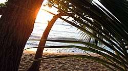 Sunset at Maria's Beach in Rincón | |
 Flag | |
| Nicknames: "El Pueblo de los Bellos Atardeceres", "Pueblo del Surfing" | |
| Anthem: "Rincón es mi pueblo querido" | |
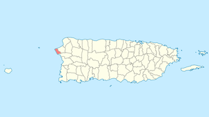 Location of Rincón in Puerto Rico | |
| Coordinates: 18°20′25″N 67°15′06″W | |
| Commonwealth | |
| Founded | 1771 |
| Government | |
| • Mayor | Carlos López Bonilla (PPD) |
| • Senatorial dist. | 4 - Mayagüez |
| • Representative dist. | 18 |
| Area | |
| • Total | 29.4 sq mi (76.12 km2) |
| • Land | 13.9 sq mi (36 km2) |
| • Water | 15.5 sq mi (40.12 km2) |
| Population (2010) | |
| • Total | 15,200 |
| • Density | 520/sq mi (200/km2) |
| Demonym(s) | Rincoeños |
| Time zone | UTC-4 (AST) |
| Postal code | 00677 |
| Area Codes | 787, 939 |
| ISO 3166 code | PUR |
| Major routes | |
| Website | www |
The municipality is home to many of the surfing beaches in Puerto Rico, including Domes, Marias,[1] Tres Palmas, Sandy Beach, Pools Beach, and Rincón Town Beach Plaza. It is also home to Caribbean beaches including Córcega Beach.
The word "Rincón" means corner. Rincón is on the northwestern part of Puerto Rico.[2]
History
Rincón was founded in 1771 by Don Luis de Añasco. In 1885, Benito Cumpiano was mayor of Ríncon and in 1890, Victor Cumpiano was Ríncon's mayor.[3]
Hurricane Maria
.jpg)
Hurricane Maria on September 20, 2017 triggered numerous landslides in Rincón with the significant amount of rainfall.[4][5]
Geography
Rincón is located on the western coast of Puerto Rico.[6]
Updated flood zone maps (as of 2019) show that Rincón is extremely vulnerable to flooding, along with Humacao, Toa Baja, Barceloneta, and Corozal. For its high levels of erosion, Rincón is vulnerable in the case of a major hurricane.[7]
Barrios
Like all municipalities of Puerto Rico, Rincón is subdivided into barrios. The municipal buildings, central square and large Catholic church are located in a barrio referred to as "el pueblo".[8][9][10][11]
- Atalaya
- Barrero
- Calvache
- Cruces
- Ensenada
- Jagüey
- Pueblo, (not to be confused with Rincón barrio-pueblo)
- Puntas
- Rincón barrio-pueblo
- Río Grande
Sectors
Barrios (which are like minor civil divisions)[12] in turn are further subdivided into smaller local populated place areas/units called sectores (which means sectors in English). The types of sectores may vary, from normally sector to urbanización to reparto to barriada to residencial, among others.[13]
Special Communities
Of the 742 places on the list of Comunidades Especiales de Puerto Rico, the following barrios, communities, sectors, or neighborhoods were in Rincón: La Playa Sector in Barrero, Cerro Los Pobres, El Pico in Atalaya, Hoyo Caliente, and Parcelas Stella.[14][15]
Bodies of water
- Gorges: Caflo García, Grande de Calvache (longest), Los Ramos, Piletas, Punta Ensenada.
- River: Río Grande
Economy
The 1968 World Surfing Championship was held at Domes Beach in Rincón. Since then, surfers from around the world have been visiting Rincón.
Rincón has a tourism economy which also boasts scuba diving, snorkeling, and sunsets.[16] Rincón has also been an area for internet-based companies to set up shop.
In 2007, Rincón was the site for the ISA World Masters where local surfer Juan Ashton won first place in the Masters division.
Agriculture
Fruits and sugar canes are the primary sources of agriculture in Rincón. Cattle ranching also is popular.
Industry

In Rincón the major industry is tourism.[17]
The Boiling Nuclear Superheater (BONUS) Reactor Facility, also known to the locals as "Domes", is a decommissioned nuclear plant in Rincón, Puerto Rico. The construction of BONUS started in 1960, and the reactor had its first controlled nuclear chain reaction on April 13, 1964, achieving full power operation in September 1965. Operation of the BONUS reactor was terminated in June 1968 because of technical difficulties and the ensuing need for high-cost modifications.[18] General decontamination of the reactor was performed with the goal of meeting unrestricted use criteria in all accessible areas of the building. Residual radioactive materials remaining in the structure were isolated or shielded to protect site visitors and workers. During subsequent years, more radioactive contamination was identified in portions of the building, and additional clean-up and shielding activities were conducted in the 1990s and early 2000s.[18] It was Puerto Rico's only nuclear reactor.
Demographics
The United States took control of Puerto Rico from Spain in the aftermath of the Spanish-American War under the terms of the Treaty of Paris of 1898 and conducted its first census of Puerto Rico, finding that the population of Rincón was 6,641.
| Historical population | |||
|---|---|---|---|
| Census | Pop. | %± | |
| 1900 | 6,641 | — | |
| 1910 | 7,275 | 9.5% | |
| 1920 | 8,476 | 16.5% | |
| 1930 | 8,178 | −3.5% | |
| 1940 | 9,256 | 13.2% | |
| 1950 | 9,888 | 6.8% | |
| 1960 | 8,706 | −12.0% | |
| 1970 | 9,094 | 4.5% | |
| 1980 | 11,788 | 29.6% | |
| 1990 | 12,213 | 3.6% | |
| 2000 | 14,767 | 20.9% | |
| 2010 | 15,200 | 2.9% | |
| U.S. Decennial Census[19] 1899 (shown as 1900)[20] 1910-1930[21] 1930-1950[22] 1960-2000[23] 2010[10] | |||
Tourism
"Art Walk", a community initiative to build the social fabric of Rincón, takes places every Thursday. Locals and tourists mingle in the Plaza de recreo in downtown Rincón to enjoy food, drinks, music and local art.[24]
Landmarks and places of interest
There are 53 beaches in Rincón.[25] Main attractions of Rincón include:
- La Bandera (Pico Atalaya)
- Domes Beach
- Steps Beach
- Balneario de Rincón
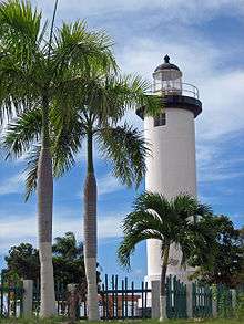
- Punta Higuero Lighthouse
- Mangia-Me, and Finn and Ollie's Pickle Barrel, a gay-friendly restaurant and pub, respectively, featured in the "Discover Puerto Rico" tourism campaign[26]
Culture
Surfing
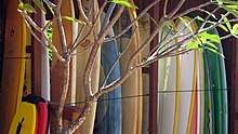
Rincón is well known as a surfing destination. Rincón rose to international recognition through the 1968 World Surfing Championship, which was held at Domes and Maria's Beaches. The winter surf along Rincón's coast is some of the best in the region. Generally regarded as one of the best surf spots across the globe, Rincón draws surfers from around the world and is the center of the island's surf scene. Dubbed the "Caribbean's Hawaii," winter waves here can approach 25–30 feet (6.7m) in height, sometimes equaling the force of the surf on Oahu's north shore. Famed surfing beaches in town include Little Malibu, Tres Palmas, Maria's, Indicators, Domes, Pools, Sandy Beach and Antonio's. The best time to surf is from November through March, but summer storms can also kick up the surf during the late summer.
Festivals and events
- Whale Festival - March
- Rincón International Film Festival 2011: April 12–16
- Coconut Festival - May
- Feast of the Patron Saint, Santa Rosa de Lima - August
- Triatlon and Triatlon Caribbean Cup
- Numerous Surfing Championships
- Local Band (Reggae and Latin Rock)
Government
Like all municipalities in Puerto Rico, Rincón is administered by a mayor. The current mayor is Carlos López Bonilla, from the Popular Democratic Party (PPD). López was elected at the 2000 general election.
The city belongs to the Puerto Rico Senatorial district IV, which is represented by two senators. In 2016, Luis Daniel Muñiz Cortés and Evelyn Vázquez were elected as District Senators.[27]
Transportation
There are 8 bridges in Rincón.[28]
Symbols
Flag
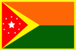
Created and designed by Evaristo Cardona Moreno and art performed by Jose Luis Cardona Martinez (his eldest son). The central white star represents the urban zone. The surrounding nine stars represent the nine wards of the municipality. The red and orange colors symbolize the vigor and the vitality of the city. The yellow represents Christianity. The green represents vegetation and the hope of the progress of the municipality. Finally, the white represents purity and the unity between the wards and the urban zone.
Coat of arms
Created and designed by Angel L. Cardona Moreno, the shield consists of a green and orange Spanish blazon, with a yellow band inclined left to right. To the right and on a green background a cross, symbol of Christendom. To the left and on an orange background a Spanish ship, symbol of the discovery of Puerto Rico, in the coasts of Rincón (this is greatly disputed, as the towns of Aguada, Rincón, and Añasco all claim entry-point status).
Notable people
Gallery
 Steps Beach
.jpg) Domes Beach
Domes Beach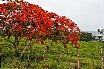 Flamboyan in Rincón
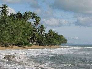
.jpg) South of Rincón
South of Rincón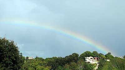 Rainbow over Rincón hills
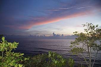 Sunset in Rincón
See also


- National Register of Historic Places listings in Rincón, Puerto Rico
References
- "History of Maria's Beach | Maria's Beach". Archived from the original on 2016-07-23. Retrieved 2016-09-20.
- "The Official Tourism Association of Rincon Homepage. Hotels, Vacation Rentals, Activities and More!". Archived from the original on 2008-03-08. Retrieved 2008-01-26.
- Puerto Rico. Office of Historian (1949). Tesauro de datos historicos: indice compendioso de la literatura histórica de Puerto Rico, incluyendo algunos datos inéditos, periodísticos y cartográficos (in Spanish). Impr. del Gobierno de Puerto Rico vol. 2. p. 306. Retrieved 2 May 2020.
- "Preliminary Locations of Landslide Impacts from Hurricane Maria, Puerto Rico". USGS Landslide Hazards Program. USGS. Archived from the original on 2019-03-03. Retrieved 2019-03-03.
- "Preliminary Locations of Landslide Impacts from Hurricane Maria, Puerto Rico" (PDF). USGS Landslide Hazards Program. USGS. Archived (PDF) from the original on 2019-03-03. Retrieved 2019-03-03.
- "Rincón Municipality". enciclopediapr.org. Fundación Puertorriqueña de las Humanidades (FPH). Archived from the original on 2017-10-27. Retrieved 2019-03-20.
- Alvarado León, Gerardo E. "Sobre 250,000 estructuras están en zonas inundables" (PDF). Junta de Planificación - Gobierno de Puerto Rico (in Spanish). El Nuevo Día. Archived (PDF) from the original on 13 June 2019. Retrieved 3 July 2019.
- Picó, Rafael; Buitrago de Santiago, Zayda; Berrios, Hector H. (1969). Nueva geografía de Puerto Rico: física, económica, y social, por Rafael Picó. Con la colaboración de Zayda Buitrago de Santiago y Héctor H. Berrios. San Juan Editorial Universitaria, Universidad de Puerto Rico,1969. Archived from the original on 2018-12-26. Retrieved 2018-12-30.
- Gwillim Law (20 May 2015). Administrative Subdivisions of Countries: A Comprehensive World Reference, 1900 through 1998. McFarland. p. 300. ISBN 978-1-4766-0447-3. Retrieved 25 December 2018.
- Puerto Rico:2010:population and housing unit counts.pdf (PDF). U.S. Dept. of Commerce Economics and Statistics Administration U.S. Census Bureau. 2010. Archived (PDF) from the original on 2017-02-20. Retrieved 2018-12-30.
- "Map of Rincón at the Wayback Machine" (PDF). Archived from the original (PDF) on 2018-03-24. Retrieved 2018-12-29.
- "US Census Barrio-Pueblo definition". factfinder.com. US Census. Archived from the original on 13 May 2017. Retrieved 5 January 2019.
- "PRECINTO ELECTORAL LARES 053" (PDF). Comisión Estatal de Elecciones (in Spanish). PR Government. 14 June 2019. Retrieved 19 June 2019.
- Rivera Quintero, Marcia (2014), El vuelo de la esperanza: Proyecto de las Comunidades Especiales Puerto Rico, 1997-2004 (First ed.), San Juan, Puerto Rico Fundación Sila M. Calderón, p. 273, ISBN 978-0-9820806-1-0
- "Comunidades Especiales de Puerto Rico" (in Spanish). 8 August 2011. Archived from the original on 24 June 2019. Retrieved 24 June 2019.
- Barbara Balletto (2003). Insight Guide Puerto Rico. Langenscheidt Publishing Group. pp. 196–. ISBN 978-981-234-949-1. Archived from the original on 2018-12-28. Retrieved 2018-12-22.
- "The Rincón Puerto Rico Online Guide". Archived from the original on 2010-09-01. Retrieved 2010-11-10.
- "BONUS, Puerto Rico, Decommissioned Reactor Fact Sheet" (PDF). Legacy Management. Department of Energy. 2009-04-04. Archived (PDF) from the original on 2009-11-19. Retrieved 2009-11-06.
- "U.S. Decennial Census". United States Census Bureau. Archived from the original on April 26, 2015. Retrieved September 21, 2017.
- "Report of the Census of Porto Rico 1899". War Department Office Director Census of Porto Rico. Archived from the original on July 16, 2017. Retrieved September 21, 2017.
- "Table 3-Population of Municipalities: 1930 1920 and 1910" (PDF). United States Census Bureau. Archived (PDF) from the original on August 17, 2017. Retrieved September 21, 2017.
- "Table 4-Area and Population of Municipalities Urban and Rural: 1930 to 1950" (PDF). United States Census Bureau. Archived (PDF) from the original on August 30, 2015. Retrieved September 21, 2014.
- "Table 2 Population and Housing Units: 1960 to 2000" (PDF). United States Census Bureau. Archived (PDF) from the original on July 24, 2017. Retrieved September 21, 2017.
- https://www.arinconvenienttruth.com/post/art-walk-a-community-effort-to-revitalize-rinc%C3%B3n-s-social-infrastructure
- "Las 1,200 playas de Puerto Rico [The 1200 beaches of Puerto Rico]". Primera Hora (in Spanish). April 14, 2017. Archived from the original on December 12, 2019. Retrieved December 12, 2019.
- https://www.discoverpuertorico.com/article/queer-qa-kara-keefe-lesbian-restaurateur
- Elecciones Generales 2012: Escrutinio General Archived 2013-01-15 at the Wayback Machine on CEEPUR
- "Rincón Bridges". National Bridge Inventory Data. US Dept. of Transportation. Archived from the original on 20 February 2019. Retrieved 19 February 2019.