Luquillo, Puerto Rico
Luquillo (Spanish pronunciation: [luˈkiʎo]) is a municipality of Puerto Rico located in the northeast coast, northwest of Fajardo; and east of Rio Grande. Luquillo is spread over 5 wards and Luquillo Pueblo (the downtown area and the administrative center of the city). It is part of the Fajardo Metropolitan Statistical Area.
Luquillo Municipio de Luquillo | |
|---|---|
Town and Municipality | |
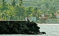 Fishing in Luquillo, Puerto Rico | |
 Flag  Coat of arms | |
| Nicknames: "Capital del Sol", "La Riviera de Puerto Rico", "Los Come Cocos" | |
| Anthem: "Junto a las costas del mar Atlántico" | |
 Location of Luquillo in Puerto Rico | |
| Coordinates: 18°22′21″N 65°43′00″W | |
| Commonwealth | |
| Founded | 1797 |
| Government | |
| • Mayor | Jesús Márquez Rodríguez (PPD) |
| • Senatorial dist. | 8 - Carolina |
| • Representative dist. | 36 |
| Area | |
| • Total | 34.26 sq mi (88.73 km2) |
| • Land | 26 sq mi (68 km2) |
| • Water | 8.00 sq mi (20.73 km2) |
| Population (2010) | |
| • Total | 20,068 |
| • Density | 590/sq mi (230/km2) |
| Demonym(s) | Luquillenses or Luquillanos |
| Time zone | UTC−4 (AST) |
| Zip code | 00773 |
| Major routes | |
The city of Luquillo is 26 square miles and it sits on 12 miles of Atlantic coastline. It is nestled between the blue waters of the Atlantic and the El Yunque National Forest, a rainforest, giving it a diverse and unique ecology. Luquillo marks the beginning of the Northeast Ecological Corridor Nature Reserve which runs down the coast from Luquillo's town square all the way down to the Seven Seas Beach in Fajardo. During certain times of the year, it is not unusual to encounter rare or endangered species of fauna (like the Leatherback Turtle) while visiting in Luquillo.[1]
History
Luquillo was founded in 1797 and is known as "La Capital del Sol" (sun capital), "La Riviera de Puerto Rico" (Puerto Rico's riviera), and "Los Come Cocos" (The coconut eaters). The town was named after the Indian cacique Loquillo, who died a few years after the last Indian rebellion in 1513.
Hurricane Maria
Hurricane Maria on September 20, 2017 triggered numerous landslides in Luquillo with the significant amount of rainfall.[2][3]
Geography
Luquillo is located on the northeast coast.[4]
Barrios
Like all municipalities of Puerto Rico, Luquillo is subdivided into barrios. The municipal buildings, central square and large Catholic church are located in a barrio referred to as "el pueblo".[5][6][7][8]
- Juan Martín
- Luquillo barrio-pueblo[9]
- Mameyes I has a Playa Fortuna Community
- Mata de Plátano has a Playa Fortuna Community
- Pitahaya
- Sabana
Sectors
Barrios (which are like minor civil divisions)[9] in turn are further subdivided into smaller local populated place areas/units called sectores (sectors in English). The types of sectores may vary, from normally sector to urbanización to reparto to barriada to residencial, among others.[10][11][12]
Tourism
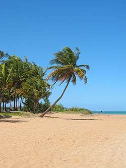
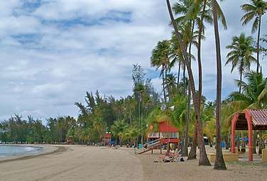
There are 14 beaches in Luquillo including La Pared.[15] If you stay on the coastal highway going east from San Juan, you'll soon reach Luquillo Beach. This huge plantation of majestic coconut palms shades more than a mile of fine and shimmering sand. It is one of the most popular and nicest public beaches in the San Juan area. It offers cafeterias, public bathrooms with showers, access for disabled people, and an ample parking lot. Monserrate Beach is one of the public beaches most frequented by the locals. In 2006 El Balneario de Luquillo (The Luquillo Beach) was pronounced the most popular one in Puerto Rico. La Pared Beach is also very popular for its surf worthy waves.
La Selva, is a small cove on the east coast. It is arguably one of the best surf spots on the east coast. The only way to get to it is about a 2-mile walk through a cow farm, but it's worth the trip if you can talk someone into telling you how to get there.
Landmarks and places of interest
- Chief Loquillo Monument
- La Fortuna Hacienda
- La Bandera Beach
- La Monserrate Beach, also known as Luquillo Beach
- La Pared Beach
- Las Pailas Beach
- Mameyes Beach
- Ocean View Boulevard
- Fortuna Beach
- The Recreational Park
- The Kiosks
- The Brass Cactus Restaurant
- Lolita's Restaurant
- La Selva Reef Break
Economy
Culture
Festivals and events
- The Three Kings' Day Celebration at the Luquillo Square - January
- Leatherback Turtle Festival - April
- Patron Saint Festivities - May
- Festival de Zangueros - June[16]
- Coconut Festival - September
- Typical Dish Festival - December
Demographics
| Historical population | |||
|---|---|---|---|
| Census | Pop. | %± | |
| 1920 | 6,251 | — | |
| 1930 | 7,799 | 24.8% | |
| 1940 | 8,851 | 13.5% | |
| 1950 | 9,967 | 12.6% | |
| 1960 | 8,582 | −13.9% | |
| 1970 | 10,390 | 21.1% | |
| 1980 | 14,895 | 43.4% | |
| 1990 | 18,100 | 21.5% | |
| 2000 | 19,817 | 9.5% | |
| 2010 | 20,068 | 1.3% | |
| U.S. Decennial Census[17] 1920-1930[18] 1930-1950[19] 1960-2000[20] 2010[7] | |||
| Ethnicity - Luquillo, Puerto Rico - 2005 [21] | ||
|---|---|---|
| Race | Population | % of Total |
| White | 10,112 | 57.4% |
| Black/African American | 4,345 | 23.7% |
| American Indian and Alaska Native | 120 | 0.6% |
| Asian | 62 | 0.3% |
| Native Hawaiian/Pacific Islander | 3 | 0.0% |
| Some other race | 2,933 | 14.8% |
| Two or more races | 610 | 3.1% |
Government
Like all municipalities in Puerto Rico, Luquillo is administered by a mayor. The current mayor is Jesús Márquez Rodríguez, who was elected at the 2012 general election.
The city belongs to the Puerto Rico Senatorial district VIII, which is represented by two Senators. In 2012, Pedro A. Rodríguez and Luis Daniel Rivera were elected as District Senators.[22]
Transportation
There is no public transportation in Luquillo, and residents and visitors rely on Uber or Luquillo Taxi & Tours for service.
There are 20 bridges in Luquillo.[23]
PR-3 is the main road through Luquillo. Other municipality roads include PR-983, PR-988, PR-991 and PR-940.[23]
Symbols
Flag
It consists of three horizontal stripes, the blue top and green bottom are double of width of the yellow central stripe. Blue makes reference to the sky and the sea; yellow represents the sand of its beaches and green represents the vegetation of the mountains. In the center stripe resides the Coat Of Arms of the town superimposed and surrounded by two palm tree leaves crossed at the bottom.
Coat of arms
In a gold background a centered mountain range with three green mountains is accompanied at the bottom by a bay with blue and silver waves; the top portion of the shield in blue, has three iris branches. Above the shield resides a three tower gold crown. Surrounding the shield by its flanks are two palms trees leaves crossed at the bottom.
Gallery
 Luquillo Beach
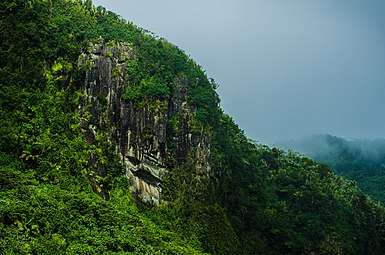 Mountain in Luquillo
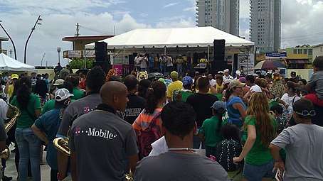 Festival in Luquillo
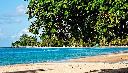 Luquillo Beach, Luquillo
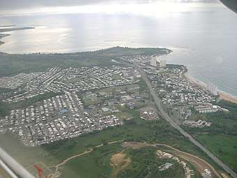 Aerial view of Luquillo
See also
- List of Puerto Ricans
- History of Puerto Rico
- Did you know-Puerto Rico?
References
- "Luquillo PR 2015: Everything You Need To Know About Luquillo". Archived from the original on 2018-10-19. Retrieved 2018-12-28.
- "Preliminary Locations of Landslide Impacts from Hurricane Maria, Puerto Rico". USGS Landslide Hazards Program. USGS. Archived from the original on 2019-03-03. Retrieved 2019-03-03.
- "Preliminary Locations of Landslide Impacts from Hurricane Maria, Puerto Rico" (PDF). USGS Landslide Hazards Program. USGS. Archived (PDF) from the original on 2019-03-03. Retrieved 2019-03-03.
- "Luquillo Municipality". enciclopediapr.org. Fundación Puertorriqueña de las Humanidades (FPH). Archived from the original on 2019-05-02. Retrieved 2019-03-20.
- Picó, Rafael; Buitrago de Santiago, Zayda; Berrios, Hector H. Nueva geografía de Puerto Rico: física, económica, y social, por Rafael Picó. Con la colaboración de Zayda Buitrago de Santiago y Héctor H. Berrios. San Juan Editorial Universitaria, Universidad de Puerto Rico,1969. Archived from the original on 2018-12-26. Retrieved 2018-12-31.
- Gwillim Law (20 May 2015). Administrative Subdivisions of Countries: A Comprehensive World Reference, 1900 through 1998. McFarland. p. 300. ISBN 978-1-4766-0447-3. Retrieved 25 December 2018.
- Puerto Rico:2010:population and housing unit counts.pdf (PDF). U.S. Dept. of Commerce Economics and Statistics Administration U.S. Census Bureau. 2010. Archived (PDF) from the original on 2017-02-20. Retrieved 2018-12-31.
- "Map of Luquillo at the Wayback Machine" (PDF). Archived from the original (PDF) on 2018-03-24. Retrieved 2018-12-29.
- "US Census Barrio-Pueblo definition". factfinder.com. US Census. Archived from the original on 13 May 2017. Retrieved 5 January 2019.
- "Agencia: Oficina del Coordinador General para el Financiamiento Socioeconómico y la Autogestión (Proposed 2016 Budget)". Puerto Rico Budgets (in Spanish). Retrieved 28 June 2019.
- Rivera Quintero, Marcia (2014), El vuelo de la esperanza: Proyecto de las Comunidades Especiales Puerto Rico, 1997-2004 (first ed.), San Juan, Puerto Rico Fundación Sila M. Calderón, ISBN 978-0-9820806-1-0
- "Leyes del 2001". Lex Juris Puerto Rico (in Spanish). Retrieved 24 June 2020.
- Rivera Quintero, Marcia (2014), El vuelo de la esperanza: Proyecto de las Comunidades Especiales Puerto Rico, 1997-2004 (1st ed.), San Juan, Puerto Rico Fundación Sila M. Calderón, p. 273, ISBN 978-0-9820806-1-0
- "Comunidades Especiales de Puerto Rico" (in Spanish). 8 August 2011. Archived from the original on 24 June 2019. Retrieved 24 June 2019.
- "Las 1,200 playas de Puerto Rico [The 1200 beaches of Puerto Rico]". Primera Hora (in Spanish). April 14, 2017. Archived from the original on December 12, 2019. Retrieved December 12, 2019.
- "Festival De Zanqueros De Puerto Rico 2019: Luquillo, Puerto Rico". Puerto Rico Hoteles y Paradores (in Spanish). 22 June 2019. Retrieved 13 June 2020.
- "U.S. Decennial Census". United States Census Bureau. Archived from the original on February 13, 2020. Retrieved September 21, 2017.
- "Table 3-Population of Municipalities: 1930 1920 and 1910" (PDF). United States Census Bureau. Archived (PDF) from the original on August 17, 2017. Retrieved September 21, 2017.
- "Table 4-Area and Population of Municipalities Urban and Rural: 1930 to 1950" (PDF). United States Census Bureau. Archived (PDF) from the original on August 30, 2015. Retrieved September 21, 2014.
- "Table 2 Population and Housing Units: 1960 to 2000" (PDF). United States Census Bureau. Archived (PDF) from the original on July 24, 2017. Retrieved September 21, 2017.
- "Ethnicity 2005" (PDF). Archived (PDF) from the original on 2008-02-16. Retrieved 2008-01-16.
- Elecciones Generales 2012: Escrutinio General Archived 2013-01-15 at the Wayback Machine on CEEPUR
- "Luquillo Bridges". National Bridge Inventory Data. US Dept. of Transportation. Archived from the original on 21 February 2019. Retrieved 20 February 2019.