Mayagüez metropolitan area
The Mayagüez Metropolitan Statistical Area is a United States Census Bureau defined Metropolitan Statistical Area (MSA) in west central Puerto Rico. A July 1, 2009 Census Bureau estimate placed the population at 109,842, a 4.53% decrease from the 2000 census figure of 115,048.[1]

Of the eight metropolitan areas in the Commonwealth, Mayagüez has experienced the largest population decline during the 2000–2009 period. The only other MSA to have lost population during this same period is Ponce.
Municipalities
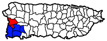
A total of two municipalities (Spanish: municipios) are included as part of the Mayagüez Metropolitan Statistical Area.[2] They are:
- Hormigueros
- Mayagüez—Principal City
Combined Statistical Area
The Mayagüez–San Germán–Cabo Rojo Combined Statistical Area (CSA) includes two metropolitan areas and six municipalities. A July 1, 2009 Census Bureau estimate placed the population at 258,401, a 2.84% increase over the 2000 census figure of 251,260. The Mayagüez–San Germán–Cabo Rojo Combined Statistical Area comprises 6.5% of Puerto Rico's total population.[3]
Components
- Metropolitan Statistical Areas (MSAs)
- Mayagüez (2 Municipalities)
- San Germán-Cabo Rojo (4 Municipalities)
See also
- Puerto Rico census statistical areas
References
- "Table 3. Annual Estimates of the Population of Metropolitan and Micropolitan Statistical Areas in Puerto Rico: April 1, 2000 to July 1, 2009 (CBSA-EST2009-03)" (CSV). 2009 Population Estimates. United States Census Bureau, Population Division. 2010-03-23. Retrieved 2010-03-31.
- "Update of Statistical Area Definitions and Guidance on Their Uses (OMB Bulletin 08 - 01)" (PDF). 2007 Population Estimates. United States Census Bureau, Population Division. 2007-11-20. Archived from the original (CSV) on 2008-11-17. Retrieved 2008-11-10.
- "Table 4. Annual Estimates of the Population of Combined Statistical Areas in Puerto Rico: April 1, 2000 to July 1, 2009 (CBSA-EST2009-04)" (CSV). 2009 Population Estimates. United States Census Bureau, Population Division. 2010-03-23. Retrieved 2010-03-31.