Dorado, Puerto Rico
Dorado (Spanish pronunciation: [doˈɾaðo]) is a town and municipality in the northern coast of Puerto Rico, 15 miles (24 km) west of San Juan and is located in the northern region of the island, bordering the Atlantic Ocean, north of Toa Alta, east of Vega Alta, and west of Toa Baja. Dorado is subdivided into five barrios and Dorado Pueblo (the downtown area and the administrative center of the city). The town is regarded as a tourist destination with golf courses, hotels, and beaches. It is part of the San Juan-Caguas-Guaynabo Metropolitan Statistical Area.
Dorado Municipio de Dorado | |
|---|---|
Town and Municipality | |
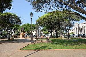 Central Square in Dorado town. | |
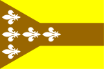 Flag 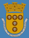 Coat of arms | |
| Nicknames: "La Ciudad Ejemplar", "Ciudad Dorada", "La Más Limpia de Puerto Rico" | |
| Anthem: "Por fin, en las riberas" | |
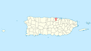 Location of Dorado in Puerto Rico | |
| Coordinates: 18°27′32″N 66°16′04″W | |
| Commonwealth | |
| Founded | 1842 |
| Barrios | |
| Government | |
| • Mayor | Carlos A. López Rivera (PPD) |
| • Senatorial dist. | 3 – Arecibo |
| • Representative dist. | 11 |
| Area | |
| • Total | 60.16 km2 (23.23 sq mi) |
| Population (2010) | |
| • Total | 38,165 |
| • Density | 630/km2 (1,600/sq mi) |
| • Racial groups (2000 Census)[1] | 48.0% White 45.0% Black 2% American Indian/AN 3.0% Asian 0.0% Native Hawaiian/PI 2.0% Arabic |
| Demonym(s) | Doradeños |
| Time zone | UTC−4 (AST) |
| Zip code | 00646 |
| Major routes | |
| Website | www |
The Dorado Airport was operated from 1942 to 1996. The airport began as a military landing strip, then became a civilian airport in the 1960s with Caribair and Dorado Wings flights operating until 1980 and 1982 respectively. The airport operated as a private landing strip throughout the 1980s and then fell into disrepair. In 1996, the airport was rezoned as residential land and redeveloped.
Dorado has upscale neighborhoods and a small downtown area with a plaza (Spanish town square), as other Puerto Rican municipalities. The town's patron saint is Anthony of Padua, and patron saint celebrations are held at the plaza every year on June 13.
History
During the early 18th century, there were already mentions of a "Sitio de Dorado" (meaning a golden place) in some San Juan registers.[2]
Since the beginning of the Spanish colonial period and until 1831, Dorado existed as a barrio (or ward) of the town of Toa Baja. Over several years, the ward grew and established its own town center called the "new pueblo" to differentiate itself from Toa Baja, which became known as the "old pueblo." Over several years, the wards that currently make up Dorado grew and the people of the "new pueblo" wanted to separate themselves from Toa Baja.
On November 22, 1842, Jacinto López Martínez, the Sergeant at Arms for the ward of Dorado, petitioned the Spanish Governor of Puerto Rico, Santiago Méndez Vigo, to establish the municipality of Dorado. The governor authorized the founding of the town pending the construction of public works, including an administrative building and a church near the town square. In 1848, the construction of the public works were completed and López Martínez became the first mayor of Dorado.
The United States acquired Puerto Rico from Spain in the aftermath of the Spanish-American War under the terms of the Treaty of Paris of 1898. In 1899, the US conducted its first census of Puerto Rico, finding that the population of Dorado was 3,804.[3] In 1902, four years after the Spanish–American War, Dorado was again appended to Toa Baja. However, in 1905 it regained its status as a separate town.
The 2nd G7 summit was held at the Dorado Beach Resort between June 27 and 28, 1976.[4]
Hurricane Maria (2017)
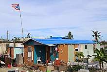
Like the rest of the island, homes in Dorado were damaged by the rain and winds of Hurricane Maria on September 20, 2017.
Flood control project
In mid 2018, the United States Army Corps of Engineers announced it would be undertaking a major flood control project of a river that often causes flooding in Dorado, Río de la Plata.[5]
Geography
Much of Dorado's geology consists of alluvial and coastal/estuarine sediments of Quaternary age and limestones of Tertiary age.[6] The limestones are mostly in the south part of the municipality, in Espinosa, Maguayo and Rio Lajas Wards. These limestones exhibit mature karst topography of great beauty. It has been subjected to extensive quarrying, which have left unsightly scars in the landscape. Some local communities have gathered efforts to minimize quarrying and improve land management to protect the remaining karst topography and the fauna and flora that lives in it.
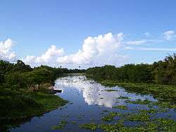
Hydrography
Some of the rivers of Dorado are:
- Rivers: Río Cocal, Río Lajas, Río de la Plata, and Río Nuevo.
- Mata Redonda lagoon
- Punta Fraile marsh
Barrios
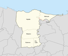
Like all municipalities of Puerto Rico, Dorado is subdivided into barrios. The municipal buildings, central square and large Catholic church are located in a barrio referred to as "el pueblo".[7][8][9]
Sectors
Barrios (which are like minor civil divisions)[10] in turn are further subdivided into smaller local populated place areas/units called sectores (which means sectors in English). The types of sectores may vary, from normally sector to urbanización to reparto to barriada to residencial, among others.[11]
Special Communities
Of the 742 places on the list of Comunidades Especiales de Puerto Rico (Special Communities of Puerto Rico), the following barrios, communities, sectors, or neighborhoods were in Dorado: El Caño, Kuilan Barrio Espinosa, La Hormiga, Sector Calondrias, Sector El Cotto, Villa 2000, Villa Iriarte, and Villa Plata.[12]
Climate
Dorado's climate is very hot in the summer months and warm in the winter. Temperatures range around 60 °F (16 °C) to 80 °F (27 °C) in the winter and 75 °F (24 °C) to 95 °F (35 °C) in the summer.
| Climate data for Dorado, Puerto Rico | |||||||||||||
|---|---|---|---|---|---|---|---|---|---|---|---|---|---|
| Month | Jan | Feb | Mar | Apr | May | Jun | Jul | Aug | Sep | Oct | Nov | Dec | Year |
| Record high °F (°C) | 90 (32) |
91 (33) |
95 (35) |
97 (36) |
98 (37) |
100 (38) |
99 (37) |
98 (37) |
101 (38) |
99 (37) |
95 (35) |
93 (34) |
101 (38) |
| Average high °F (°C) | 78 (26) |
80 (27) |
83 (28) |
84 (29) |
88 (31) |
91 (33) |
92 (33) |
92 (33) |
90 (32) |
87 (31) |
82 (28) |
81 (27) |
86 (30) |
| Average low °F (°C) | 63 (17) |
64 (18) |
66 (19) |
70 (21) |
72 (22) |
73 (23) |
77 (25) |
77 (25) |
77 (25) |
75 (24) |
69 (21) |
66 (19) |
71 (22) |
| Record low °F (°C) | 50 (10) |
49 (9) |
50 (10) |
59 (15) |
62 (17) |
67 (19) |
68 (20) |
68 (20) |
69 (21) |
60 (16) |
55 (13) |
53 (12) |
49 (9) |
| Average precipitation inches (mm) | 3.55 (90) |
3.11 (79) |
1.02 (26) |
2.78 (71) |
3.55 (90) |
7.20 (183) |
6.20 (157) |
5.84 (148) |
5.60 (142) |
3.71 (94) |
8.47 (215) |
5.65 (144) |
56.68 (1,439) |
| Source: The Weather Channel[13] | |||||||||||||
Culture
Tourism

In the early 20th century the Rockefeller family purchased plots of land in the northwest region of the municipality of Dorado where they built a huge private vacation compound. Laurance Rockefeller would later use this land to create Dorado Beach Hotel and Golf Club, which later became the Dorado Beach Hyatt Hotel which closed in 2007. Dorado Beach Hotel became a Ritz Carlton hotel in 2012.
Dorado has long been known as a golf haven. Its tourist industry includes the Dorado Beach Resort (Ritz-Carlton Reserve & Plantation), the Hyatt Hacienda del Mar, and Embassy Suites in the Dorado Del Mar neighborhood. As of 2014 there are three operating golf courses in the municipality, the Dorado Beach East Course, the Plantation Sugarcane Course and the Plantation Pineapple Course. The Dorado del Mar course closed in 2014.
Landmarks and places of interest
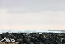
Dorado has 24 beaches, including Balneario Manuel Nolo Morales.[14]
Some of the places to visit in Dorado are located downtown. For example, the Museum Casa del Rey is the house built in most towns controlled by Spain during their colonization, which was intended for the King and Queen to stay if they visited. The museum includes several artifacts from the era. There's also the Distinguished Doradeños Plaza, and the Juan Boria Theater. The last one was recently reopened after a long period of restoration.
Some of the most visited beaches in Dorado are Sardinera, Kikita and El Unico are other beaches frequented by surfers. The Ojo del Buey Park is a park located at the base level of the La Plata River. The name comes from a rock formation that has the shape of an ox.
Dorado also has a church called the Sanctuary of Christ of the Reconciliation, that has the third largest statue of Jesus Christ in the Caribbean, inside its temple.
Festivals and events
Dorado's Fiestas Patronales are held in June. Other traditional festivals held at the city are "El Carnaval del Plata" which is celebrated in the beginning of February and the "Cocolía" Festival which is celebrated in the end of June/beginning of August, etc.
Economy
Agriculture
In 2007, there were ten farms in Dorado, are producing plantains, coffee, vegetables or melons, bananas, root crops or tubers, grains, grasses and other crops, poultry and eggs, cattle and calves, milk products, hogs and pigs, aquaculture, other livestock, and other livestock products. The top livestock produced in Dorado are cattle and calves, horses, hogs and pigs. The top crop items were lawn grass (sod), coffee, pigeon peas, cassava, and other vegetables.[15]
Business
Commerce Tourism and pharmaceuticals
Industry
Dorado is the site of several industries dedicated to the manufacturing of clothing and medical equipment, among others. Companies like Boston Scientific, Pfizer and Heraeus are among some of the ones located in the city.
Housing developments
In recent years, Dorado has been known for its development of upscale neighborhoods. Several known politicians and artists (e.g. Ricky Martin, Carlos Romero Barceló) live or own properties in the city.
Demographics
| Historical population | |||
|---|---|---|---|
| Census | Pop. | %± | |
| 1900 | 3,804 | — | |
| 1910 | 4,885 | 28.4% | |
| 1920 | 5,842 | 19.6% | |
| 1930 | 7,579 | 29.7% | |
| 1940 | 9,481 | 25.1% | |
| 1950 | 11,749 | 23.9% | |
| 1960 | 13,460 | 14.6% | |
| 1970 | 17,388 | 29.2% | |
| 1980 | 25,511 | 46.7% | |
| 1990 | 30,759 | 20.6% | |
| 2000 | 34,017 | 10.6% | |
| 2010 | 38,165 | 12.2% | |
| U.S. Decennial Census[16] 1899 (shown as 1900)[17] 1910-1930[18] 1930-1950[19] 1960-2000[20] 2010[21] | |||
Dorado's population has steadily increased during the past century. The current population, according to the 2000 census, is of 34,017 with a population density of 1,479.0 people per square mile (568.8/km²) more than doubling the town's population of 17,388 in 1970.
As a whole, Puerto Rico is populated mainly by people from a Creole (born on the Island of European descent) or Spanish and European descent, with small groups of African and Asian people. Statistics taken from the 2000 census shows that 74.1% of Doradeños have Spanish or White origin, 12.2% are black, 0.5% are Amerindian etc.
| Race – Dorado, Puerto Rico – 2000 Census[22] | ||
|---|---|---|
| Race | Population | % of Total |
| White including Hispanic | 25,219 | 74.1% |
| African American | 4,147 | 12.2% |
| American Indian and Alaska Native | 157 | 0.5% |
| Asian | 60 | 0.2% |
| Native Hawaiian/Pacific Islander | 7 | 0.0% |
| Some other race | 3,214 | 9.4% |
| Two or more races | 1,213 | 3.6% |
Government
All municipalities in Puerto Rico are administered by a mayor, elected every four years. The current mayor of Dorado is Carlos López Rivera, of the Popular Democratic Party (PPD). He was elected at the 1988 general elections.
The city belongs to the Puerto Rico Senatorial district III, which is represented by two Senators. In 2012, José "Joito" Pérez and Angel Martínez were elected as District Senators.[23]
Symbols
Flag
The flag is composed of three stripes of equal width: the upper and lower stripes are golden, and the center one is brown. A brown, equal-sided triangle is placed with its base at the hoist.
Coat of arms
The crown is gold with brown windows. The three towers mean that Dorado is a town, a properly constituted municipality. Underneath the crown, there are five disks that form a Tau.
Education
Dorado has several public and private schools distributed through several regions. Including TASIS, Dorado Academy, New Testament Christian Academy of Dorado, and Public education is handled by the Puerto Rico Department of Education.
José S. Alegría is the public High School, located in the town center. Ricardo Arroyo Laracuente is the Middle School 7th through 9th Grade. In the town next to the town square is the elementary School named Jacinto López Martínez.
Schools and academies
- Dorado Academy
- TASIS Dorado
- José S. Alegría High School
- Pedro López Canino Elementary and Middle School
- Luis Muñoz Marín Elementary School
- Ricardo Arroyo Middle School
- Marcelino Canino Canino – Middle School
- Jacinto López Martínez – Elementary school and first school building to be founded in Dorado. It is over a hundred years old and still in use and one of the biggest schools.
- Luisa Valderrama Martínez – Elementary school
- The Jane Stern Dorado Community Library, founded in 1974, is Puerto Rico's first public bilingual library. Recipient of a 2008 National Medal for Museum and Library Service.
Health care
Dorado's main health facility is a Center for Diagnostic and Treatment located at Road 698. The facility is able to handle emergency cases, but severe cases are transferred to bigger hospitals in nearby towns such as Bayamón or Manatí.[24]
Transportation
Puerto Rico Highway 22 provides access to Dorado from the far away city of Mayagüez, or from San Juan. Road 165 also provides access from Cataño and Bayamón bordering the shore to the Atlantic Ocean. It takes approximately 30 minutes to reach the town from San Juan.
Like most other towns in the island, it has a public transportation system consisting of public cars. Taxis are also available around the town. There's also a public trolley system around town and a shuttle service for handicapped people.
There are 19 bridges in Dorado.[25]
Dorado Airport was a commercial airport that served the city with flights to San Juan and to the United States, but it has since been closed.
See also
References
- 2000 Census of Population and Housing: Puerto Rico. Profiles of General Demographics Characteristics, 2000. May 2001. U.S. Department of Commerce. U.S. Census Bureau. Archived 2008-02-16 at the Wayback Machine Ponce Census Statistics: U.S 2000 census. Retrieved November 23, 2009.
- "Dorado - Municipio de Puerto Rico". Portal PRFrogui. Archived from the original on March 3, 2016. Retrieved June 29, 2016.
- Joseph Prentiss Sanger; Henry Gannett; Walter Francis Willcox (1900). Informe sobre el censo de Puerto Rico, 1899, United States. War Dept. Porto Rico Census Office (in Spanish). Imprenta del gobierno. p. 161.
- Japan, Ministry of Foreign Affairs (MOFA): Summit Meetings in the Past; Archived 2009-04-30 at WebCite Shabecoff, Philip. "Go-Slow Policies Urged by Leaders in Economic Talks," Archived 2018-07-22 at the Wayback Machine New York Times. June 29, 1976; excerpt, "SAN JUAN, P.R., June 28 President Ford and six other leaders of industrial democracies announced here today that they had agreed to pursue the objective of sustained economic growth.... The leaders met at the palm fringed Dorado Beach Resort near here."
- "USACE: $3.348 billion go toward reducing flood risk in Florida, Puerto Rico and USVI". Caribbean Business. 6 July 2018. Archived from the original on 1 June 2019. Retrieved 1 June 2019.
- "Dorado Municipality". enciclopediapr.org. Fundación Puertorriqueña de las Humanidades (FPH). Archived from the original on 2019-06-10. Retrieved 2019-03-20.
- Picó, Rafael; Buitrago de Santiago, Zayda; Berrios, Hector H. Nueva geografía de Puerto Rico: física, económica, y social, por Rafael Picó. Con la colaboración de Zayda Buitrago de Santiago y Héctor H. Berrios. San Juan Editorial Universitaria, Universidad de Puerto Rico,1969. Archived from the original on 2018-12-26. Retrieved 2019-01-07.
- Gwillim Law (20 May 2015). Administrative Subdivisions of Countries: A Comprehensive World Reference, 1900 through 1998. McFarland. p. 300. ISBN 978-1-4766-0447-3. Retrieved 25 December 2018.
- "Map of Dorado at the Wayback Machine" (PDF). Archived from the original (PDF) on 2018-03-24. Retrieved 2018-12-29.
- "US Census Barrio-Pueblo definition". factfinder.com. US Census. Archived from the original on 13 May 2017. Retrieved 5 January 2019.
- "PRECINTO ELECTORAL DORADO 015" (PDF). Comisión Estatal de Elecciones. PR Government. 27 September 2019. Retrieved 19 June 2019.
- Rivera Quintero, Marcia (2014), El vuelo de la esperanza:Proyecto de las Comunidades Especiales Puerto Rico, 1997-2004 (Primera edición ed.), San Juan, Puerto Rico Fundación Sila M. Calderón, p. 273, ISBN 978-0-9820806-1-0
- "Ocala, Florida Weather". The Weather Channel. Archived from the original on 2011-09-27. Retrieved 2011-08-12.
- "Las 1,200 playas de Puerto Rico [The 1200 beaches of Puerto Rico]". Primera Hora (in Spanish). April 14, 2017. Archived from the original on December 12, 2019. Retrieved December 12, 2019.
- "2007 Census of Agriculture" (PDF). www.nass.usda.gov. USDA. Retrieved 19 June 2020.
- "U.S. Decennial Census". United States Census Bureau. Archived from the original on February 13, 2020. Retrieved September 21, 2017.
- "Report of the Census of Porto Rico 1899". War Department, Office Director Census of Porto Rico. Archived from the original on July 16, 2017. Retrieved September 21, 2017.
- "Table 3-Population of Municipalities: 1930, 1920, and 1910" (PDF). United States Census Bureau. Archived (PDF) from the original on August 17, 2017. Retrieved September 21, 2017.
- "Table 4-Area and Population of Municipalities, Urban and Rural: 1930 to 1950" (PDF). United States Census Bureau. Archived (PDF) from the original on August 30, 2015. Retrieved September 21, 2014.
- "Table 2 Population and Housing Units: 1960 to 2000" (PDF). United States Census Bureau. Archived (PDF) from the original on July 24, 2017. Retrieved September 21, 2017.
- Puerto Rico:2010:population and housing unit counts.pdf (PDF). U.S. Dept. of Commerce, Economics and Statistics Administration, U.S. Census Bureau. 2010. Archived (PDF) from the original on 2017-02-20. Retrieved 2019-01-07.
- "Ethnicity 2000 census" (PDF). Archived (PDF) from the original on 2008-02-16. Retrieved 2009-04-03.
- "Senadores por Distrito, Resultados Distrito Senatorial Arecibo III". State Elections Commission of Puerto Rico. 2012-11-09. Archived from the original on 2012-11-30. Retrieved 2012-11-11.
- "Emergency Medical Center". 2010. Archived from the original on February 23, 2016. Retrieved June 21, 2016.
- "Dorado Bridges". National Bridge Inventory Data. US Dept. of Transportation. Archived from the original on 20 February 2019. Retrieved 19 February 2019.
External links
- Darts fly like birds : atlatl hooks and other shell artifacts from the Punta Mameyes site, Dorado, Puerto Rico (in French)
- Puerto Rico Government Directory - Dorado