Río Grande, Puerto Rico
Río Grande (Spanish pronunciation: [ˈri.o ˈɣɾande]) is a municipality of Puerto Rico located in the Northern Coastal Valley, north of Las Piedras, Naguabo and Ceiba; east of Loíza and Canóvanas and west of Luquillo. Río Grande is spread over eight wards and Río Grande Pueblo (the downtown area and the administrative center of the city). It is part of the San Juan-Caguas-Guaynabo Metropolitan Statistical Area.
Río Grande Municipio de Río Grande | |
|---|---|
City and Municipality | |
.jpg) | |
 Flag | |
| Nickname(s): "La Ciudad del Yunque" | |
| Anthem: "Entre las ondas que juguetean" | |
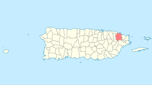 Location of Río Grande in Puerto Rico | |
| Coordinates: 18°22′49″N 65°49′53″W | |
| Commonwealth | |
| Founded | July 16, 1840 |
| Government | |
| • Mayor | Hon. Angel "Bori" González (PPD) |
| • Senatorial dist. | 8 - Carolina |
| • Representative dist. | 36,37 |
| Area | |
| • Total | 89.6 sq mi (232.11 km2) |
| • Land | 60.7 sq mi (157.28 km2) |
| • Water | 28.9 sq mi (74.83 km2) |
| Population (2010) | |
| • Total | 54,304 |
| • Density | 610/sq mi (230/km2) |
| Demonym(s) | Riograndeños |
| Time zone | UTC−4 (AST) |
| Zip code | 00721, 00745 |
| Major routes | |
History
Río Grande was founded on July 16, 1840, by Desiderio and Quilimaco Escobar, with the approbation of governor Miguel López. It was named after the Río Grande and is located where the Río Grande and the Río Espíritu Santo join.
In 1894, there were two sugar cane haciendas and 256 estancias growing minor fruits.[1]
Hurricane Maria
Hurricane Maria on September 20, 2017 triggered numerous landslides in Río Grande with the significant amount of rainfall.[2][3]
Geography
Río Grande is on the northeastern coast and Sierra Luquillo Mountains.[4]
Barrios
Like all municipalities of Puerto Rico, Río Grande is subdivided into barrios (which mean wards or boroughs or neighborhoods in Spanish). The municipal buildings, central square and a large Catholic church are located in a small, central barrio called barrio-pueblo or simply Pueblo.[5][6][7]
Sectors
Barrios (which are like minor civil divisions)[8] in turn are further subdivided into smaller local populated place areas/units called sectores (which means sectors in English). The types of sectores may vary, from normally sector to urbanización to reparto to barriada to residencial, among others.[9][10][11][12][13][14]
Special Communities
Of the 742 places on the list of Comunidades Especiales de Puerto Rico (Special Communities of Puerto Rico), the following barrios, communities, sectors, or neighborhoods are in Río Grande: Sector Montebello and Sector El Hoyo in Malpica, Las Dolores, La Ponderosa, Villa Realidad, Estancias del Sol, and Hong Kong.[15][16]
Demographics
In 1894, while a Spanish colony, the population of Río Grande was 6,237.[1]
The United States took control of Puerto Rico from Spain in the aftermath of the Spanish-American War under the terms of the Treaty of Paris of 1898. In 1899, the United States conducted its first census of Puerto Rico in 1899 finding that the population of Río Grande was 12,365.
| Historical population | |||
|---|---|---|---|
| Census | Pop. | %± | |
| 1900 | 12,365 | — | |
| 1910 | 13,948 | 12.8% | |
| 1920 | 13,247 | −5.0% | |
| 1930 | 14,085 | 6.3% | |
| 1940 | 16,116 | 14.4% | |
| 1950 | 16,651 | 3.3% | |
| 1960 | 17,233 | 3.5% | |
| 1970 | 22,032 | 27.8% | |
| 1980 | 34,283 | 55.6% | |
| 1990 | 45,648 | 33.2% | |
| 2000 | 52,362 | 14.7% | |
| 2010 | 54,304 | 3.7% | |
| U.S. Decennial Census[17] 1899 (shown as 1900)[18] 1910-1930[19] 1930-1950[20] 1960-2000[21] 2010[6] | |||
Tourism
Río Grande is home to one of the largest secluded areas with beach access (Coco Beach) on the entire island. Major hotels in the area include Wyndham Grand Rio Mar Resort and Hyatt Regency Grand Reserve. Every March, Hyatt Regency Grand Reserve plays host to the PGA Tour's Puerto Rico Open.
Within a ten-minute drive is El Yunque National Forest, the only tropical rain forest within the United States National Forest System.[22]
Hotels
- The Wyndham Rio Mar Beach Resort and Spa
- Hyatt Regency Grand Reserve
- St. Regis Bahía Beach Resort & Golf Club
Landmarks and places of interest
There are 27 beaches in Río Grande.[23] Main attractions of Río Grande are:
- Coco Beach
- El Yunque
- Indio Cave
- Las Picúas Beach
Economy
Agriculture
Fruits, ornamental plants, vegetables, and cattle.
Business
Local retail stores are aside highway PR-3. Large shopping centers were not present mainly due to the closeness of the Canóvanas shopping district area. However, there is one large shopping mall located on 65th Infantry expressway and 956th street. Because it is relatively new, many of its spaces are not leased yet. Together both cities are growing economically very fast and becoming the eastern economic bloc of the northeastern area of Puerto Rico attracting hotels, shopping malls, sport venues among others. Another thing that is making Río Grande more attractive to tourists and businesses alike is the newly constructed and opened Route 66 (or Ruta 66), which makes it a lot more accessible and more appealing to home buyers.
In 2019, volunteers and police who formed a group called Consejo Comunitario de Seguridad de Río Piedras celebrated their 32nd year aiding local businesses with security issues. This group works to ensure the safety and security of business patrons in the downtown area of Río Piedras.[24]
Industry
Manufacture of textiles.
Culture
Festivals and events
- Cross Festival (May)
- Patron Celebrations (July)
Sports
Baseball, basketball and handball are popular sports in Río Grande. Also many play tennis.
Government
Like all municipalities in Puerto Rico, Río Grande is administered by a mayor. The current mayor is Angel "Bori" González, who was elected in a special election on September 14, 2014. González is replacing Eduard Rivera Correa, who was elected at the 2004 general election. However, Rivera Correa stepped down from office after being indicted on federal charges.[25]
The city belongs to the Puerto Rico Senatorial district VIII, which is represented by two senators. In 2012, Pedro A. Rodríguez and Luis Daniel Rivera were elected as District Senators.[26]
Transportation
There are 48 bridges in Río Grande.[27]
Symbols
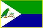
Flag
The Río Grande flag consists of two horizontal stripes of equal size, upper one is green with lower one been blue, and united by a white triangle placed on the side of the mast. On the white triangle is a Puerto Rican parrot.
Coat of arms
In a silver field, two Puerto Rican parrot (Amazona vitatta), accompanied by a waving blue stripe, a green mountain with three peaks. The top portion of the shield is blue, with an opened silver book, accompanied on each side by five gold coins. Topped by a three tower gold crown outlined in black with green openings.
Gallery
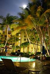 Wyndham Grand Rio Mar Beach Resort & Spa
 Evening at El Yunque
 Winding road at El Yunque
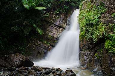 Waterfall in El Yunque
See also
- List of Puerto Ricans
- History of Puerto Rico
- Did you know-Puerto Rico?
References
- Blanch, José (December 23, 1894). "Directorio comercial é industrial de la isla de Puerto-Rico para 1894. Formado con relaciones oficiales remitidas por los sres. alcaldes municipales de cada localidad" (in Spanish). Puerto-Rico, "La correspondencia" – via Internet Archive.
- "Preliminary Locations of Landslide Impacts from Hurricane Maria, Puerto Rico". USGS Landslide Hazards Program. USGS. Archived from the original on 2019-03-03. Retrieved 2019-03-03.
- "Preliminary Locations of Landslide Impacts from Hurricane Maria, Puerto Rico" (PDF). USGS Landslide Hazards Program. USGS. Archived (PDF) from the original on 2019-03-03. Retrieved 2019-03-03.
- "Río Grande Municipality". enciclopediapr.org. Fundación Puertorriqueña de las Humanidades (FPH). Archived from the original on 2017-10-26. Retrieved 2019-03-20.
- Gwillim Law (20 May 2015). Administrative Subdivisions of Countries: A Comprehensive World Reference, 1900 through 1998. McFarland. p. 300. ISBN 978-1-4766-0447-3. Retrieved 25 December 2018.
- Puerto Rico:2010:population and housing unit counts.pdf (PDF). U.S. Dept. of Commerce Economics and Statistics Administration U.S. Census Bureau. 2010. Archived (PDF) from the original on 2017-02-20. Retrieved 2018-12-26.
- "Map of Río Grande at the Wayback Machine" (PDF). Archived from the original (PDF) on 2018-03-24. Retrieved 2018-12-29.
- "US Census Barrio-Pueblo definition". factfinder.com. US Census. Archived from the original on 13 May 2017. Retrieved 5 January 2019.
- "DESGLOSE DE SECTORES Y CENTROS DE VOTACIÓN PRECINTO ELECTORAL - RÍO GRANDE 101" (PDF). Comisión Estatal de Elecciones Puerto Rico (in Spanish). 15 February 2019. Archived (PDF) from the original on 17 June 2020. Retrieved 16 June 2020.
- "DESGLOSE DE SECTORES Y CENTROS DE VOTACIÓN PRECINTO ELECTORAL - RÍO GRANDE 102". Comisión Estatal de Elecciones Puerto Rico (in Spanish). 15 February 2019. Archived (PDF) from the original on 17 June 2020. Retrieved 16 June 2020.
- Mari Mut, José A. (28 August 2013). "Los pueblos de Puerto Rico y las iglesias de sus plazas" (in Spanish). Retrieved 19 June 2020 – via archive.org.
- "Agencia: Oficina del Coordinador General para el Financiamiento Socioeconómico y la Autogestión (Proposed 2016 Budget)". Puerto Rico Budgets (in Spanish). Retrieved 28 June 2019.
- Rivera Quintero, Marcia (2014), El vuelo de la esperanza : Proyecto de las Comunidades Especiales Puerto Rico, 1997-2004 (Primera edición ed.), San Juan, Puerto Rico Fundación Sila M. Calderón, ISBN 978-0-9820806-1-0
- "Leyes del 2001". Lex Juris Puerto Rico (in Spanish). Retrieved 24 June 2019.
- Rivera Quintero, Marcia (2014), El vuelo de la esperanza:Proyecto de las Comunidades Especiales Puerto Rico, 1997-2004 (First ed.), San Juan, Puerto Rico Fundación Sila M. Calderón, p. 273, ISBN 978-0-9820806-1-0
- "Comunidades Especiales de Puerto Rico" (in Spanish). 8 August 2011. Archived from the original on 24 June 2019. Retrieved 24 June 2019.
- "U.S. Decennial Census". United States Census Bureau. Archived from the original on February 13, 2020. Retrieved September 21, 2017.
- "Report of the Census of Porto Rico 1899". War Department Office Director Census of Porto Rico. Archived from the original on July 16, 2017. Retrieved September 21, 2017.
- "Table 3-Population of Municipalities: 1930 1920 and 1910" (PDF). United States Census Bureau. Archived (PDF) from the original on August 17, 2017. Retrieved September 21, 2017.
- "Table 4-Area and Population of Municipalities Urban and Rural: 1930 to 1950" (PDF). United States Census Bureau. Archived (PDF) from the original on August 30, 2015. Retrieved September 21, 2014.
- "Table 2 Population and Housing Units: 1960 to 2000" (PDF). United States Census Bureau. Archived (PDF) from the original on July 24, 2017. Retrieved September 21, 2017.
- "Land Areas of the National Forest System" (PDF). U.S. Forest Service. January 2012. Archived (PDF) from the original on January 16, 2013. Retrieved June 28, 2012.
- "Las 1,200 playas de Puerto Rico [The 1200 beaches of Puerto Rico]". Primera Hora (in Spanish). April 14, 2017. Archived from the original on December 12, 2019. Retrieved December 12, 2019.
- "Consejo Comunitario de Seguridad de Río Piedras celebra 32 años de lucha y trabajo voluntario • WIPR". December 11, 2019. Archived from the original on December 13, 2019. Retrieved December 13, 2019.
- Criollo Oquero, Agustín (September 14, 2014). "Ángel "Bori" González es el nuevo alcalde de Río Grande". El Nuevo Día. Retrieved September 17, 2014.
- Elecciones Generales 2012: Escrutinio General Archived 2013-01-15 at the Wayback Machine on CEEPUR
- "Río Grande Bridges". National Bridge Inventory Data. US Dept. of Transportation. Archived from the original on 21 February 2019. Retrieved 20 February 2019.