Aguadilla, Puerto Rico
Aguadilla (Spanish pronunciation: [aɣwaˈðiʝa]), founded in 1775 by Luis de Córdova, is a city and municipality located in the northwestern tip of Puerto Rico, bordered by the Atlantic Ocean to the north and west, north of Aguada, and Moca and west of Isabela. Aguadilla is spread over 15 wards and Aguadilla Pueblo (the downtown area and the administrative center of the city). It is a principal city of Aguadilla-Isabela-San Sebastián Metropolitan Statistical Area.
Aguadilla | |
|---|---|
City and Municipality | |
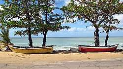 Aguadilla, near Schoolyards Beach | |
 Flag | |
| Nicknames: El Nuevo Jardín del Atlántico, La Villa del Ojo de Agua, El Pueblo de los Tiburones | |
| Anthem: Playita Aguadillana | |
 Location of Aguadilla in Puerto Rico | |
| Coordinates: 18°25′48″N 67°9′16″W | |
| Commonwealth | |
| Founded | 1775 |
| Founded by | Luis de Córdova |
| Government | |
| • Mayor | Yanitsia Irizarry Méndez (NPP) |
| • Senatorial dist. | 4 – Mayagüez/Aguadilla |
| • Representative dist. | 17 |
| Area | |
| • Total | 76.3 sq mi (198 km2) |
| • Land | 36.6 sq mi (95 km2) |
| • Water | 39.0 sq mi (101 km2) 51% |
| Elevation | 326 ft (99 m) |
| Population (2016) | |
| • Total | 54,582 |
| • Density | 720/sq mi (280/km2) |
| Demonym(s) | Aguadillanos |
| Racial groups | |
| • 2010 Census | 83.0% Hispanic 7.4% Black 0.3% American Ind/AN 0.2% Asian 6.8% Some other race 2.4% Two or more races |
| Time zone | UTC−4 (AST (no daylight saving time)) |
| Zip code | 00603, 00604, 00605, 00690 |
| Area code | 787, 939 |
| Major routes | |
| Website | aguadilla.gobierno.pr |
History
According to sources, a Taíno settlement called Amamón was located close to the Culebrinas River.[2]
The present territory of Aguadilla was originally part of the territory of Aguada. In 1775, the foundation of Aguadilla by Don Luis de Córdova was approved.[3] But it wasn't until 1780 that the territory was properly segregated, making the founding of the town official. Originally, Aguadilla was constituted by the Victoria and Higüey wards.[4] This region was already inhabited and known as Aguadilla before 1770. In 1776, Fray Íñigo Abbad y Lasierra in his description of the towns of the island, mentioned it as the "new Town of San Carlos of the Aguadilla." Nevertheless, according to Dr. Agustín Stahl in his Foundation of Aguadilla, it was not until 1780 that the town was officially founded. The construction of a new church and the proceedings to become an independent village began in the 1775.

The population in the Village of Aguadilla continued to increase constantly mainly due to its excellent port and strategic location in the route of the boats. In 1776, when Santo Domingo became independent for the first time, the Spanish descended loyals emigrated to Puerto Rico, mainly to Aguadilla, which caused the population to continue increasing significantly. In 1831, according to Don Pedro Tomás de Córdova, the party of Aguadilla belonged to Aguada. At this time, the territorial organization of Aguadilla was as follows: Pueblo Norte (North Town), Pueblo Sur (South Town), Ceiba Alta, Ceiba Baja, Montaña, Malezas, Aguacate, Dos Palmas, Camaseyes, Plainela, Borinquen, Arenales, Higüey, Corrales, Victoria, and Mangual.
Don Pedro Tomás de Córdova mentions the road of Aguadilla formed by Punta Borinquen and San Francisco, as the "fordeadero of the ships that travel from Europe to Havana and Mexico". He adds that its "port is the most frequented in the Island due to the proportions that it offers to refresh all class of ship."
In 1860, Aguadilla was officially declared a village.[4] Several years later, when the island was territorially organized into seven departments, Aguadilla became the head of the third department that included the municipalities of Aguada, Isabela, Lares, Moca, Rincon, and San Sebastián. In January 1841 a Royal Order transferred the judicial party from Aguada to Aguadilla. In 1878, according to Don Manuel Ebeda y Delgado, the territorial organization of Aguadilla had varied a little. At this time Plainela, Higüey, and Mangual wards are not mentioned. The Dos Palmas ward appears as Palmar. Also at this time, three new wards are mentioned: Guerrero, Caimital Alto, and Caimital Bajo. In 1898, even with the change of sovereignty in the island, the territorial organization of Aguadilla is the same to that of 1878. Nevertheless, in the Census of 1899, downtown Aguadilla appears constituted by Higüey, Iglesia, Nueva, Santa Barbara, and Tamarindo wards. Malezas ward appears subdivided into Maleza Alta and Maleza Baja. From that time, the territorial organization of Aguadilla did not change, until 1948, when the Puerto Rico Department of Planning prepared the map of the city and its wards, and following instructions of city authorities, Higüey and parts of Caimital Alto wards are annexed to Downtown Aguadilla.
Ramey Air Force Base

Aguadilla was the site of the U.S. military's Ramey Air Force Base for almost five decades. During this period, Aguadilla was home to the Strategic Air Command, equipped with RB-36s and 72d Bombardment Wing, Heavy equipped with B-52s, an important strategic facility during the Cold War. Activated in June 1952 as a Strategic Air Command very long range reconnaissance unit at Ramey AFB, Puerto Rico, but not operational until October 1952. Redesignated as 72d Strategic Reconnaissance Wing and received 3 (60th, 73rd and 301st) squadrons of RB-36D/E/F/H Peacemaker bombers. Also th 915th Air Rescue Squadron. Conducted global strategic reconnaissance 1953–1955, gradually shifting to a bombardment training mission beginning in 1954, being upgraded to B-36J and B-36J(III) Featherweights by 1955. Redesignated 72d Bombardment Wing in 1958.. With the phaseout of the B-36s in 1958, received B-52G Stratofortess intercontinental strategic bombers.
Though the infrastructure still exists, the airport was handed over to the Government of Puerto Rico in 1973. The aerial facilities are now controlled by the Puerto Rico Ports Authority and comprise the Rafael Hernandez International Airport. The barracks now host the Faro Inn Suites, a 79-room hotel. The Officer's Club now hosts the Faro Conference Center, a 22,000-square-foot (2,000 m2) meeting facility. The hospital is now the Courtyard by Marriott Punta Borinquen Resort & Casino,[5] a 150-room hotel with a casino and the first Marriott in Puerto Rico out of the San Juan Metropolitan Area.
Ramey also hosts the University of Puerto Rico – Aguadilla Campus and the Friedrich Froebel Bilingual School[6] (K-9). The High School became Ramey Job Corps[7] Campus and the elementary school became the Esther Feliciano Mendoza Middle School. Centro de Adiestramiento y Bellas Artes (CABA) since 1979 has been the only public school of arts in Puerto Rico (7–12). Ramey is also the site of the new Ramey Skating Park and a new "mariposario" (butterfly farm) and the Ramey Shopping Center.
There is still an active part of the base that hosts the Coast Guard Borinquen Air Station. There are also other government agencies based at Ramey. They include the United States Department of Homeland Security, U.S. Customs & Border Protection's Office of Air and Marine and Office of Border Patrol, the Fuerzas Unidas de Rápida Acción (United Forces for Rapid Action) of the Puerto Rico Police Department and the Puerto Rico National Guard.
There is also a post office, the Centro de Servicios al Conductor (Driver's Services Center), a bakery, and a Banco Popular de Puerto Rico location.
San Antonio

The beginning of San Antonio Village was back in the mid-19th century. It was composed by 60 families. Originally the place where these families were located was known as Bajura de Vadi, place later to be known as San Antonio.
In 1918, as a consequence of the 1918 San Fermín earthquake, the village was totally destroyed by a tsunami. The families suffered the struggles cause by this natural disaster, due by the proximity of the village to the shore.
The residents of the village decided re-localize the village in a higher area further from shore. The new location was what today is known as Ramey.
At this new location prosperity was not to be delayed. Various leaders and commercial owners of the time, took a step to carry the village forward. Most of the poor houses disappeared.
The village's infrastructure started its evolution. Luis R. Esteves and Juan Garcia established the first two theaters in the area. A new was social club form, known as "Luz del Porvenir" (Light of the Future). A new school system was the pride of the village because it offered them the opportunity to give their children an education without having to go 9 miles (14 km) south downtown. There was also a new bakery and a post office, among other facilities. At this time, the village also began its Patron Festival.
The clothing industry was a major source of employment.
In September 1939, some 3,796 acres (15.4 km2) covered by sugar cane, was expropriated for the military at the cost of $1,215,000, in order to build an air base that came to be known as Ramey Air Force Base.
Since the foundation, the village has suffered three expropriations as a result of expansions to Ramey Air Force Base. This expropriations delayed and ended the plans to turn San Antonio into a town.
Today, the population of San Antonio consists of approximately ten thousand people. It has a modern square, a Puerto Rico State Police Station, a coliseum, an industrial park, public housing, a baseball park, a public school system, shops, and many other, characteristics of a small town. Also, as a characteristic of a town, has a flag and an emblem. The creation of the flag and emblem was done by Roberto Román Acevedo.
Tragedy on election day in 1944

On the early morning hours of November 7, 1944, Puerto Rico suffered the most violent railroad accident in its history in Aguadilla.[8] Train No. 3 was traveling from San Juan to Ponce carrying passengers to their different hometowns for the island general elections to be held that same day. It stopped at the Jimenez Station in Aguadilla for a routine engineer and boilerman exchange with Train No. 4 which was heading towards San Juan. The engineer assigned to Train No. 3's ride from Jimenez Station to Ponce was Jose Antonio Roman, an experienced freight train engineer, but who had never worked in passenger travel.[8] When the train left the station at 2:00 am, it was hauling 6 passenger cars with hundreds of commuters and two freight cars.

At 2:20 a.m. the train started to descend a hill section known as Cuesta Vieja (Old Hill) in Aguadilla at what some witnesses described as an exaggerated speed. When the train reached the leveling-off point at the bottom of the hill it derailed. The steam locomotive crashed into a ditch where it exploded and one of the freight cars crashed into one of the passenger cars, killing many inside. Witnesses described the scene as horrendous, with some accounts stating that parents were throwing their children out the windows to save them from the wreckage.[8] Chief of Police Guillermo Arroyo stated that the locomotive (No. 72), the express car, and three second class passenger cars were completely destroyed. Oscar Valle, an Aguadilla correspondent to the local El Mundo newspaper, summarized the scene in a more dramatic way: "The locomotive suffered a terrible explosion as it derailed, and the impact was so strong that 3 passenger cars were converted into a fantastic mound of wreckage".[8] In the end, 16 passengers lost their lives, including the engineer and the boilerman, and 50 were injured in the crash.[9]
Hurricane Maria
The four radar systems used by the Federal Aviation Administration for flights in and around Puerto Rico were damaged when Hurricane Maria hit the island on September 20, 2017, and took nearly two weeks to fix. One of the radar systems is located in Aguadilla.[10]
Geography
Aguadilla is located in the northwest coast of the island of Puerto Rico, in the Western Coastal Plains. It is bordered by the Atlantic Ocean in the north, the municipalities of Isabela on the east, and Moca and Aguada in the south.[11]
The area of the municipality is 35.5 square miles. It is mostly plain, with some notable hills being Jiménez (728 feet) and Viñet (689 feet). It has only one river, the Culebrinas, which separates Aguadilla from Aguada. Also Cedro Creek which separates Aguadilla from Isabela in the north.[11]
Barrios

Like all municipalities of Puerto Rico, Aguadilla is subdivided into barrios. The municipal buildings, central square and large Catholic church are located in a small barrio referred to as "el pueblo", near the center of the municipality.[12][13]
Sectors

Barrios (which are like minor civil divisions)[14] in turn are further subdivided into smaller local populated place areas/units called sectores (which means sectors in English). The types of sectores may vary, from normally sector to urbanización to reparto to barriada to residencial, among others.[15]
Special Communities
Of the 742 places on the list of Comunidades Especiales de Puerto Rico (Special Communities of Puerto Rico), the following barrios, communities, sectors, or neighborhoods are in Aguadilla: El Palmar, Cerro Calero, Cerro Visbal, Cuesta Vieja, La Vía, and Poblado San Antonio.[16]
Temperature of sea
| Jan | Feb | Mar | Apr | May | Jun | Jul | Aug | Sep | Oct | Nov | Dec | Year |
|---|---|---|---|---|---|---|---|---|---|---|---|---|
| 77 °F (25 °C) | 75 °F (24 °C) | 77 °F (25 °C) | 77 °F (25 °C) | 79 °F (26 °C) | 81 °F (27 °C) | 84 °F (29 °C) | 84 °F (29 °C) | 86 °F (30 °C) | 84 °F (29 °C) | 82 °F (28 °C) | 79 °F (26 °C) | 78.8 °F (26.0 °C) |
Economy

The city is currently home to a variety of industrial and pharmaceutical plants like LifeScan, Symmetricom, Honeywell, and Hewlett Packard Enterprise. Most of them are located at San Antonio Technological Park. The airport has Lufthansa Technik,[18] while others like Suiza Dairy, Lockheed Martin and Productos La Aguadillana are located in Camaseyes Industrial Park. Other industries that are based in Aguadilla are rubber, plastics, leather, textiles, steel, wood, machinery, and food processing.[19][11]
The retail sector is another source of economy in Aguadilla. Shopping malls like Aguadilla Mall, Aguadilla Shopping Center, Aguadilla Town Center, and others are some of the main commercial and retail centers of the city.

In 2019, Aguadilla received the City Livability Award from the United States Conference of Mayors and honored the efforts spearheaded by Carlos Méndez Martínez. Specifically mentioned was "Pintalto", a project where Cerro Cabrero area, in the downtown area of Aguadilla was painted in rich, lively colors.[20]
Tourism

Aguadilla is part of the Porta del Sol touristic region in Puerto Rico. The Porta del Sol website highlights Aguadilla's beaches for surfing.[21]
According to the Department of Natural Resources, Aguadilla has the most beaches in the island, with nineteen.[22] Some of the beaches are considered among the best for surfing, like Surfer's Beach, Gas Chambers, Crash Boat, Wilderness, among others.[23][24] Because of this, Aguadilla has served as host to surfing competitions, like the ISA World Championship in 1988.[25]
Other attractions of the town are Las Cascadas Water Park and the Aguadilla Ice Skating Arena, which is the only ice skating complex in the Caribbean.
Landmarks and places of interest
- Aguadilla City Hall – Originally built in 1918. Reconstructed after the 1918 earthquake.
- Banyan Treehouse – Wooden House around a banyan tree. None of its parts touches the tree.
- Campanitas de Cristal Fountain
- Cathedral San Carlos Barromeo
- Christopher Columbus Monument – Consists of a cross originally made of marble. It also had to be rebuilt after the earthquake.
- Cristobal Colón Park
- El Merendero
- El Parterre Jose de Jesus Esteves "Ojo de Agua"
- Fisherman's Monument
- Jardin del Atlántico Square
- Las Cascadas (The Waterfalls) Water Park
- Old Sugar Pier
- Paseo Miguel Garcia Mendez
- Punta Borinquen Golf Course – Is an 18-hole golf course, originally built for President Dwight D. Eisenhower.
- Punta Borinquen Lighthouse
- Punta Borinquen Lighthouse Ruins
- Rafael Hernández Monument
- Rafael Hernandez Square
- Ramey Skate Park New
- Tribunal Supremo (Old Courthouse)
- Youth Fountain Juan Ponce de León Park
Beaches

There are 32 beaches in Aguadilla.[26] Some of the more well known beaches include:
- Balneario Municipal de Aguadilla (GNIS ID 1990599)
- Playa La Ruina (GNIS ID 1991881) also called Wilderness Beach or Las Ruinas ("The Ruins" in Englsh)[27][28]
- Playa Punta Borinquen (GNIS ID 1991891)
- Crash Boat Beach
- Survival Beach[29]
- Surfer's Beach[30]
- Rompeolas Beach / Rompeolas Beach North aka Tamarindo[31]
Culture
Events and festivals
Aguadilla is the site of several yearly celebrations and festivals.[32] The most notable are:
- Velorio de Reyes – Celebrated mostly in January, they are a religious ceremony held as gratitude to the Three Kings for some answered prayer. They usually consist of hymns, prayers, and other religious expressions.[33]
- Kite Festival – Held in April, it includes kiosks, music, and kite flying.[34]
- Fiestas San Antonio – April[35][32]
- Verbena de Corrales – May[32]
- Beach Festival – June[36]
- Festival del Atún – Celebrated in July, it is a festival dedicated to the fishing of the tuna.
- Festival de la Música – July[32]
- Fiestas Patronales San Carlos – October[32]
Sports
Aguadilla is home to several professional and amateur sports teams. The most notable are the Aguadilla Divas of the Female Superior Volleyball League, and the Aguadilla Sharks of the Superior Baseball League (Double-A). The Divas play their home games in the Luis T. Diaz Coliseum in Downtown Aguadilla from January to March, while the Sharks play their home games at Luis A. Canera Marquez Stadium from February to May.
| Club | League | Sport | Venue |
|---|---|---|---|
| Aguadilla Sharks | Superior Baseball League | Baseball | Luis A. Canera Marquez Stadium |
| Aguadilla Divas | Female Superior Volleyball League | Volleyball | Luis T. Diaz Coliseum |
Aguadilla also had a professional basketball team called the Aguadilla Sharks, that played for the BSN league. This team was merged into the Cangrejeros de Santurce in 1998.
Aguadilla is also a place where many famous baseball players originate from. There are plans for a future ECHL Minor League Hockey franchise for the city.
Communication
Radio
Demographics
| Historical population | |||
|---|---|---|---|
| Census | Pop. | %± | |
| 1900 | 17,830 | — | |
| 1910 | 21,419 | 20.1% | |
| 1920 | 24,287 | 13.4% | |
| 1930 | 28,319 | 16.6% | |
| 1940 | 34,956 | 23.4% | |
| 1950 | 44,357 | 26.9% | |
| 1960 | 47,864 | 7.9% | |
| 1970 | 51,355 | 7.3% | |
| 1980 | 54,606 | 6.3% | |
| 1990 | 59,335 | 8.7% | |
| 2000 | 64,685 | 9.0% | |
| 2010 | 60,949 | −5.8% | |
| Est. 2016 | 54,582 | [37] | −10.4% |
| U.S. Decennial Census[38] 1899 (shown as 1900)[39] 1910-1930[40] 1930-1950[41] 1960-2000[42] 2010[43] 2016[37] | |||
The 1887 census conducted by Spain showed Aguadilla had a population of 16,140.[44]
According to the US 2010 Census, there were 60,949 people in the city. This represents a decrease of more than 3,000 from the 2000 Census.[45][46] The population density was 1,668.5 inhabitants per square mile (644.2/km2). There were 20,821 housing units. 23.7% of residents were under the age of 18 and 15.5% were 65 years of age or older. The gender make up was 48.6% male and 51.4% female.
As a whole, Puerto Rico is populated mainly by people from a Creole (born on the Island of European descent) or Spanish and European descent, with small groups of African and Asian people. Statistics taken from the 2000 census shows that 83.6% of Aguadillanos have Spanish or white origin, 5.0% are black, 0.2% are Amerindian, 0.2% Asian, 0.1% Native Hawaiian/Pacific Islander, 8.2% were Some other race, 2.8% Two or more races.
In March 2012, unemployment was at 16.2%, which is the same percent it was in November 2010.[47]
Religion
Most of Aguadillanos are Christian with a majority being Roman Catholic. Like most cities in Puerto Rico Aguadilla has their Catholic Church located on the plaza in their downtown. There is also a significant community of Protestants including; Pentecostals, Adventists and Jehovah's Witnesses. Aguadilla also has many people who are irreligious or atheist. Aguadilla has an Islamic community (Arabic:المجتمع الإسلامي) with and Islamic Center located on PR-111 in the Palmar ward.
Government
City
All municipalities in Puerto Rico are administered by a mayor, elected every four years. The current mayor of Aguadilla is Yanitsia Irizarry Méndez, of the New Progressive Party (PNP). She was elected in 2020 by municipality delegates, after the ex mayor Carlos Méndez Martínez announce he waiver. Aguadilla City Government is based at the city hall in downtown Aguadilla.
State
Most state agencies are based at the Government Center Building with the exception of the Corporación del Seguro del Estado (State Insurance Agency) and the Centro de Servicios al Conductor (Driver's Services Center). Most state agencies left their offices after the Senatorial District was taken away from Aguadilla.
Public safety
Aguadilla has its own police department, Policía Municipal Aguadilla (Aguadilla City Police Department), located in Aguadilla Pueblo. The A.C.P.D. only has jurisdiction in the municipality of Aguadilla and provide service and protection to local citizens and travelers alike.
Aguadilla also hosts the Puerto Rico Police Department Command for its Region. This region covers Aguada, Aguadilla, Isabela, Moca, Rincón and San Sebastián. It also hosts the PRPD Highway Patrol Division for its region, the FURA Division of the PRPD, the US Army Reserve Center, PR National Guard, U.S. Coast Guard, and the Border Patrol. It is also served by another PRPD station in San Antonio Village (Precinct 203 Ramey-San Antonio).
The city has a single correctional facility, Guerrero Correctional Institution, operated by the Puerto Rico Department of Corrections and Rehabilitation.
In recent years, Aguadilla has seen an increase in Type I crimes, which include murder, burglary, and theft.[47]
Mayors
| # | Mayor | Term | Party | Notes |
|---|---|---|---|---|
| 1st | Adrián del Valle | 1899–1903 | None | |
| 2nd | José Monserrate Deliz | 1903–1905 | None | |
| 3rd | Luis A. Torregrosa | 1905–1907 | None | |
| 4th | José Francisco Estévez | 1907–1911 | None | |
| 5th | Ramón Añeses Morell | 1911–1933 | None | |
| 6th | Wenceslao Herrera Alfonso | 1933–1941 | None | |
| 7th | José Badillo Nieves | 1941–1945 | None | |
| 8th | Rodolfo Acevedo | 1945 | None | |
| 9th | Fernando Milán | 1945–1949 | None | |
| 10th | Rafael Cabán Peña | 1949–1953 | None | |
| 11th | Rafael A. Guntín López | 1953–1957 | None | |
| 12th | Herminio Blás | 1957 | None | |
| 13th | José Acevedo Álvarez | 1957–1969 | None | |
| 14th | Emilio Cerezo Muñoz | 1969–1973 | PNP | |
| 15th | Conchita Igartúa de Suárez | 1973–1977 | PPD | |
| 16th | Joaquín Acevedo Moreno | 1977–1981 | PNP | |
| 17th | Alfredo González Pérez | 1981–1987 | PPD | |
| 18th | Gustavo Herrera López | 1987–1988 | PPD | Interim |
| 19th | Ramón Calero Bermúdez | 1988–1996 | PNP | Died in 1996 while in office |
| 20th | Agnes Bermúdez Acevedo | 1996–1997 | PNP | Interim |
| 21st | Carlos Méndez Martínez | 1997 – 2020 | PNP | Resigned on January 27, 2020 |
| 22nd | Yanitsia Irizarry Méndez | 2020–present | PNP | Incumbent |
Senate
The city belongs to the Puerto Rico Senatorial district IV, which is represented by two Senators. In 2016, Evelyn Vázquez and Luis Daniel Muñiz were elected as District Senators.
Education
Public schools
In all of the island's municipalities, public education is overseen by the Puerto Rico Department of Education. Aguadilla hosts the Head Start Program for Aguadilla, Aguada, Moca, Rincón, and San Sebastián and a number of private institutions.
As of 2018-2019 the following public schools were operational in Aguadilla:[49][50]
- Ana M. Javariz is a rural, elementary school, located in Urb. El Prado, offering grades K-6, with about 215 students.
- Antonio Badillo Hernandez is a rural, elementary school, located in Montaña, offering grades K-6, with about 327 students.
- Homero Rivera Sola is a rural, elementary school, located in Corrales barrio, offering grades K-6, with about 153 students.
- Jose de Diego is a rural, elementary school, located in Res. Jose de Diego, offering grades K-6, with about 242 students.
- Luis Muñoz Rivera is a rural, elementary school, located in Camaseyes barrio, offering grades K-6, with about 206 students.
- Antonio Badillo Hernandez is a rural, intermediate school, located in Montaña barrio, offering grades 7–9, with about 336 students.
- Ester Feliciano Mendoza is a rural, intermediate school offering grades 6–8, with about 416 students.
- Benito Cerezo Vazquez is a rural, high school, located in Borinquen barrio, offering grades 10–12, with about 435 students.
- Juan Suarez Pelegrina is a rural, high school, located in Montaña barrio, offering grades 10–12, with about 715 students.
- Salvador Fuentes is a rural, high school, located in Ramey base, offering grades 10–12, with about 288 students.
- Centro de Adiestramiento y Bellas Artes (CABA) is a school that specializes in the arts, located in Ramey base. In 2016, it served about 500 students.[51]
- Su Conchita Iguartua de Suarez is a rural, elementary school offering grades Pre-8, with about 768 students.
Higher education
Aguadilla hosts the following universities:
- Puerto Rico Aviation Maintenance Institute
- Aeronautical and Aerospace Institute of Puerto Rico (AAIPR)
- University of Puerto Rico (UPR), Aguadilla Campus[52]
- Metropolitan University, Aguadilla Campus[53]
- Inter American University of Puerto Rico, Aguadilla Campus[54]
- Automeca Technical College[55]
- Puerto Rico Criminal Justice College, Aguadilla Campus (Puerto Rico Police Academy) Ramey Job Corps[7] also serves those who want to attain a higher education.
Aguadilla Library System
There is an existent library in San Antonio Village and another one in downtown Aguadilla (Aguadilla barrio-pueblo).
Health
There are two major medical facilities in Aguadilla.
- Hospital Buen Samaritano (Good Samaritan Hospital)[56]
- Aguadilla Medical Services[57]
- Sala de Urgencias San Francisco (road#2)
- Metro Pavia Clinic Aguadilla[58]
There are also a number of private doctor's offices.
Transportation

Air
Rafael Hernández Airport is located in the city of Aguadilla. In recent years, it has seen a resurgence as an international airport in the island, with several airlines planning flights to the US from Aguadilla.
Roads
Interstate PR-2 (Rafael Henández Highway). Plans are underway for a new expressway, an expansion to existing Puerto Rico Highway 22 (José de Diego Expressway) from Hatillo and it will probably end at Puerto Rico Highway 111. There are 13 bridges in Aguadilla.[59]
Public
King Face Public Transportation Terminal
Notable people from Aguadilla
Due to space limitations it is almost impossible to list all of the people of Aguadilla who have distinguished themselves, therefore a category has been created to this effect:
Gallery
 Aguadilla City Hall
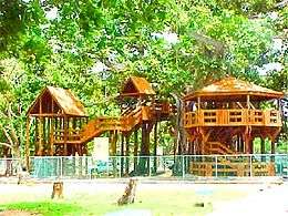 Banyan Treehouse
 Campanitas de Cristal Fountain
 Roman Catholic Parish Church San Carlos Borromeo
 Columbus Cross
 El Merendero
 El Parterre
 Fisherman's Monument
 Jardin del Atlántico Sq.
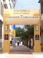 Paseo Miguel Garcia Mendez
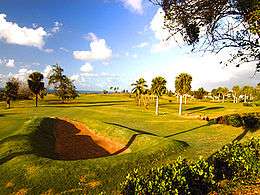 Punta Borinquen Golf Course
 Punta Borinquen Lighthouse
 Punta Borinquen Lighthouse Ruins
 Rafael Hernández Monument
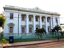 Old Courthouse
 Board Walk
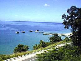 Crash Boat Beach
 Cerro Echevarría Sector, Aguadilla barrio-pueblo
See also
- History of Puerto Rico
- List of Puerto Ricans
- National Register of Historic Places listings in Aguadilla, Puerto Rico
References
- "Demographics/Ethnic 2000 census" (PDF). Archived (PDF) from the original on 2008-02-16. Retrieved 2008-07-27.
- Caciques y Yucayeques de Puerto Rico Archived November 7, 2012, at the Wayback Machine on Proyecto Salon Hogar
- Aguadilla Archived 2013-03-15 at the Wayback Machine on BoricuaOnline.com
- Aguadilla: Fundación e historia Archived 2013-03-15 at the Wayback Machine on Enciclopedia de Puerto Rico
- "Marriott.com". Archived from the original on 2007-10-12. Retrieved 2007-09-25.
- "Archived copy". Archived from the original on 2012-08-27. Retrieved 2012-08-06.CS1 maint: archived copy as title (link)
- "Home | Ramey Job Corps Center". ramey.jobcorps.gov. Archived from the original on September 29, 2006.
- La Tragedia del 7 de noviembre de 1944 (The Tragedy of November 7, 1944) by Haydee E. Reichard de Cancio, El Nuevo Dia, Por Dentro Section, Pg. 116, December 7, 1996, retrieved on July 31, 2006 (in Spanish)
- "Puerto Rico y aquel tren que nunca llegó a destino" (in Spanish). Archived from the original on 2019-09-28. Retrieved 2019-09-28.
- "Puerto Rico Air National Guard returns key radar to service". National Guard. Archived from the original on 2019-07-04. Retrieved 2019-07-04.
- "Aguadilla Municipality". Enciclopedia PR. Fundación Puertorriqueña de las Humanidades (FPH). Archived from the original on 14 February 2019. Retrieved 14 February 2019.
- Gwillim Law (20 May 2015). Administrative Subdivisions of Countries: A Comprehensive World Reference, 1900 through 1998. McFarland. p. 300. ISBN 978-1-4766-0447-3. Retrieved 25 December 2018.
- "Map of Aguadilla at the Wayback Machine" (PDF). Archived from the original (PDF) on 2018-03-24. Retrieved 29 December 2018.
- "US Census Barrio-Pueblo definition". factfinder.com. US Census. Archived from the original on 13 May 2017. Retrieved 5 January 2019.
- "PRECINTO ELECTORAL LARES 053" (PDF). Comisión Estatal de Elecciones (in Spanish). PR Government. 14 June 2019. Retrieved 19 June 2020.
- Rivera Quintero, Marcia (2014), El vuelo de la esperanza: Proyecto de las Comunidades Especiales Puerto Rico, 1997-2004 (First ed.), San Juan, Puerto Rico Fundación Sila M. Calderón, p. 273, ISBN 978-0-9820806-1-0
- Bilbao Climate Archived 2014-07-02 at the Wayback Machine – weather2travel.com
- "En constante crecimiento la industria aeroespacial en Puerto Rico" (in Spanish). WIPR. October 16, 2019. Archived from the original on October 20, 2019. Retrieved October 20, 2019.
- Aguadilla Archived 2012-07-08 at the Wayback Machine on Enciclopedia de Puerto Rico
- GmbH, finanzen.net (June 29, 2019). "Plano & Aguadilla Deemed". markets.businessinsider.com. Archived from the original on August 18, 2019. Retrieved August 18, 2019.
- Porta del Sol – Pueblos Archived June 5, 2012, at the Wayback Machine on Porta del Sol
- Jesús Omar Rivera. "En Aguadilla ¡...son tan lucíos!". Primera Hora (in Spanish). Archived from the original on 2014-06-30. Retrieved 2012-05-27.
- Surf West – Surf Aguadilla Archived 2012-04-11 at the Wayback Machine on Surfing Puerto Rico
- "Aguadilla Surf Spots". Archived from the original on 2009-12-27. Retrieved 2012-05-27.
- ISA World Gold Medalists Archived 2010-07-15 at the Wayback Machine on ISA
- "Las 1,200 playas de Puerto Rico [The 1200 beaches of Puerto Rico]". Primera Hora (in Spanish). April 14, 2017. Archived from the original on December 12, 2019. Retrieved December 12, 2019.
- "The Ruins @ Wilderness, Aguadilla, Puerto Rico (aka: Las Ruinas, Wildo)". 3 December 2013. Archived from the original on 27 March 2019. Retrieved 27 March 2019.
- "Two of the best beaches in Puerto Rico - Luxury Vacation, Wedding and Honeymoon". Archived from the original on 2018-09-15. Retrieved 2019-03-27.
- "Hike to Survival Beach - Puerto Rico Day Trips Travel Guide". Puerto Rico Day Trips. Archived from the original on 2019-03-27. Retrieved 2019-03-27.
- "Surfer's Beach - Aguadilla, Puerto Rico - Surfing Beaches - West Coast PR". Archived from the original on 2019-03-27. Retrieved 2019-03-27.
- "Rompeolas Beach - Aguadilla, Puerto Rico - Full Visitor's Guide to Aguadilla". Archived from the original on 2019-03-27. Retrieved 2019-03-27.
- Pariser, Harry S. (2003). Explore Puerto Rico, Fifth Edition. San Francisco: Manatee Press. pp. 52–55. Retrieved 10 February 2019.
- Velorios de Reyes Archived 2010-10-18 at the Wayback Machine on AguadillaPR
- Festival de la Chiringa Archived March 13, 2013, at the Wayback Machine on Negocio.com
- "How About 10 (Or More) Days of Partying in San Antonio?". TripSavvy. Archived from the original on 2017-12-11. Retrieved 2017-12-11.
- Aguadilla: Eventos Archived 2012-03-20 at the Wayback Machine on Enciclopedia de Puerto Rico
- "Population and Housing Unit Estimates". United States Census Bureau. Retrieved September 21, 2017.
- "U.S. Decennial Census". United States Census Bureau. Archived from the original on February 13, 2020. Retrieved September 21, 2017.
- "Report of the Census of Porto Rico 1899". War Department, Office Director Census of Porto Rico. Archived from the original on July 16, 2017. Retrieved September 21, 2017.
- "Table 3-Population of Municipalities: 1930, 1920, and 1910" (PDF). United States Census Bureau. Archived (PDF) from the original on August 17, 2017. Retrieved September 21, 2017.
- "Table 4-Area and Population of Municipalities, Urban and Rural: 1930 to 1950" (PDF). United States Census Bureau. Archived (PDF) from the original on August 30, 2015. Retrieved September 21, 2014.
- "Table 2 Population and Housing Units: 1960 to 2000" (PDF). United States Census Bureau. Archived (PDF) from the original on July 24, 2017. Retrieved September 21, 2017.
- Puerto Rico:2010:population and housing unit counts.pdf (PDF). U.S. Dept. of Commerce, Economics and Statistics Administration, U.S. Census Bureau. 2010. Archived (PDF) from the original on 2017-02-20. Retrieved 2019-06-10.
- "Censo de la Isla de Puerto-Rico - Censo de 1887" (PDF). Fondo documental del Instituto Nacional de Estadística. Spanish government. Retrieved 27 December 2019.
- Censo 2000: Población por Barrios – Municipio de Aguadilla Archived 2014-07-01 at the Wayback Machine on CEEPUR
- Población de Puerto Rico por Municipios, 2000 y 2010 Archived 2012-06-03 at the Wayback Machine on Elections Puerto Rico
- Ruíz Kuilan, Gloria. "Aguadilla: rey de las apariencias". El Nuevo Día. Archived from the original on 2012-07-08. Retrieved August 23, 2012.
- "San Juan". Federal Bureau of Investigation. Archived from the original on 2019-07-03. Retrieved 2019-06-23.
- "Directorio Comprensivo de Escuelas Públicas, Puerto Rico 2018 | Puerto Rico Government Open Data Portal". data.pr.gov. Archived from the original on 2018-10-04. Retrieved 2020-03-28.
- "Search for Public Schools". National Center for Education Statistics (NCES) Home Page, a part of the U.S. Department of Education. Retrieved 31 March 2020.
- https://www.primerahora.com/noticias/puerto-rico/notas/caba-recibe-reconocimiento/
- "UPRAG.edu". Archived from the original on 2006-11-14. Retrieved 2006-11-11.
- "Archived copy". Archived from the original on 2016-08-17. Retrieved 2016-08-17.CS1 maint: archived copy as title (link)
- "Aguadilla.inter.de". Archived from the original on 2006-11-28. Retrieved 2006-11-11.
- "Automeca Technical College". Web Archive Org. 7 November 2006. Archived from the original on 7 November 2006.
- "Archived copy". Archived from the original on 2018-05-19. Retrieved 2018-12-28.CS1 maint: archived copy as title (link)
- "Archived copy". Archived from the original on 2017-09-19. Retrieved 2018-12-28.CS1 maint: archived copy as title (link)
- "Archived copy". Archived from the original on 2016-10-10. Retrieved 2016-08-17.CS1 maint: archived copy as title (link)
- "Aguadilla Bridges". National Bridge Inventory Data. US Dept. of Transportation. Archived from the original on 21 February 2019. Retrieved 19 February 2019.
External links
| Wikimedia Commons has media related to Aguadilla, Puerto Rico. |
| Wikivoyage has a travel guide for Aguadilla. |
- Aguadilla and its barrios, United States Census Bureau
- Official Government Page of Municipality of Aguadilla
- Aguadilla.com – Portada
- Mi Aguadillita Querida
- Welcome to Puerto Rico! Aguadilla
- Map of Aguadilla Puerto Rico
- Porta del Sol: Aguadilla