San Germán, Puerto Rico
San Germán (Spanish pronunciation: [saŋ xeɾˈman]) is a municipality located in the southwestern region of Puerto Rico, south of Mayagüez and Maricao, north of Lajas, east of Hormigueros and Cabo Rojo, and west of Sabana Grande. San Germán is spread over eighteen wards plus San Germán Pueblo (the downtown area and the administrative center of the city). It is both a principal city of the San Germán–Cabo Rojo Metropolitan Statistical Area and the Mayagüez–San Germán–Cabo Rojo Combined Statistical Area. San Germán is the second oldest city of Puerto Rico, after San Juan.[2] The island of Puerto Rico was once split between the San Juan and the San Germán municipalities. The latter covered the western half of Puerto Rico, and extended from the western shores of the island to Arecibo in the north and Ponce in the south.
San Germán, Puerto Rico Municipio Autónomo de San Germán | |
|---|---|
City and Municipality | |
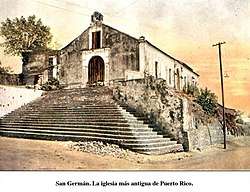
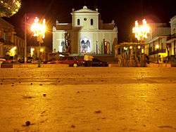
.jpg) Porta Coeli Church is the most recognized landmark of San Germán. | |
 Flag 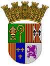 Coat of arms | |
| Nicknames: "La Ciudad de las Lomas", "Ciudad de las Golondrinas", "Ciudad Fundadora de Pueblos", "Ciudad Cuna del Baloncesto Puertorriqueño", "Ciudad Peregrina" | |
| Anthem: "San Germán es mi pueblo querido" | |
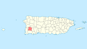 Location of San Germán in Puerto Rico | |
| Coordinates: 18°N 67°W | |
| Commonwealth | |
| Founded | 1511 1512 (on 2nd site) |
| Government | |
| • Mayor | Isidro A. Negrón Irizarry (PPD) |
| • Senatorial dist. | Mayagüez |
| • Representative dist. | 20 |
| Area | |
| • City and Municipality | 54.51 sq mi (141.18 km2) |
| • Land | 54.51 sq mi (141.18 km2) |
| • Water | 0.0 sq mi (0 km2) |
| Elevation | 528 ft (161 m) |
| Population (2010[1]) | |
| • City and Municipality | 35,527 |
| • Density | 650/sq mi (250/km2) |
| • Metro | 136,212 |
| • CSA | 251,260 |
| Demonym(s) | Sangermeños |
| Time zone | UTC−4 (AST) |
| ZIP codes | 00683, 00636 |
| Major routes | |
History
The population of San Germán when Alonso Manso was named the first bishop of Puerto Rico in 1511 was "about 50 neighbors".[3]
Spanish settlement in San Germán occurred early in the conquest and colonization of Puerto Rico. After the destruction of a small early settlement near modern-day Añasco during a Taíno uprising which started in February 1511, in 1512[4] the new settlement was built by Miguel Diaz at Guayanilla[5] and named after Germaine of Foix, the new queen of King Fernando.[6][7] This town was attacked by French corsairs in August 1528, May 1538 and 1554. The construction of a small fort began in 1540, but work stopped in 1546 when the population of the town began moving inland to the current modern location.
An early written reference to the new town occurs in 1573. A letter sent to Spain's king Philip II mentions a city with the names of Nueva Salamanca and San Germán. Spanish conquerors used the name Nueva Salamanca to honor the city of Salamanca in Spain.
On May 12, 1571, the Royal Audience (Real Audiencia) of Santo Domingo authorized that both the populations of San Germán and Santa María de Guadianilla be merged into a single city due to the constant French attacks.[8] The new city was built on the hills of Santa Marta, next to the Guanajibo River in 1573. Its official name was Nueva Villa de Salamanca, named after the city of Salamanca in Spain. However, the population called the city San Germán el Nuevo (The New San Germán) and, eventually, the Villa de San Germán (The Village of San Germán).
San Germán is also known as the founding city of towns, given the fact that in 1514 the Spanish crown separated the island into two administrative territories (Partidos). The borders of the two partidos were established as the Camuy River to the north and the Jacagua river to the south. They were named the San Juan Partition and the San Germán Partition.
Geography
San Germán is in the southwest. Mountains in San Germán include Alto del Descanso (2,520 ft; 768 m) and Tetas de Cerro Gordo (2,897 ft; 883 m). San Germán has a number of rivers: Río Caín, Río Duey, Río Rosario, Río Guanajibo (Estero), Río Hoconuco Guamá and Rio El Brujo.[9]
Hurricane Maria
Hurricane Maria on September 20, 2017 triggered numerous landslides in San Germán with the significant amount of rainfall.[10][11]
Barrios

Like all municipalities of Puerto Rico, San Germán is subdivided into barrios. The municipal buildings, central square and large Catholic church are located in a barrio referred to as "el pueblo".[12][13]
Sectors
Barrios (which are like minor civil divisions)[14] in turn are further subdivided into smaller local populated place areas/units called sectores (sectors in English). The types of sectores may vary, from normally sector to urbanización to reparto to barriada to residencial, among others.[15][16][17]
Special Communities
Of the 742 places on the list of Comunidades Especiales de Puerto Rico, the following barrios, communities, sectors, or neighborhoods were in San Germán: Ancones, Comunidad El Retiro, Comunidad Las Quebradas, La Tea, Parcelas Las Carolinas, Parcelas Minillas en Barrio Minillas, Parcelas Sabana Eneas, and Rosario Peñón.[18]
Climate
| Month | Jan | Feb | Mar | Apr | May | Jun | Jul | Aug | Sep | Oct | Nov | Dec | Year |
|---|---|---|---|---|---|---|---|---|---|---|---|---|---|
| Record high °F (°C) | 91.0 (32.8) |
91.9 (33.3) |
95 (35) |
95 (35) |
95 (35) |
99.0 (37.2) |
99.0 (37.2) |
97.0 (36.1) |
98.1 (36.7) |
97.0 (36.1) |
98.1 (36.7) |
98.1 (36.7) |
99.0 (37.2) |
| Average high °F (°C) | 87.1 (30.6) |
87.1 (30.6) |
88.0 (31.1) |
89.1 (31.7) |
90.0 (32.2) |
91.0 (32.8) |
91.9 (33.3) |
91.9 (33.3) |
91.0 (32.8) |
90.0 (32.2) |
89.1 (31.7) |
88.0 (31.1) |
89.5 (32.0) |
| Daily mean °F (°C) | 75.0 (23.9) |
75.0 (23.9) |
75.9 (24.4) |
78.1 (25.6) |
80.1 (26.7) |
81.0 (27.2) |
81.0 (27.2) |
81.0 (27.2) |
81.0 (27.2) |
80.1 (26.7) |
78.1 (25.6) |
75.9 (24.4) |
78.5 (25.8) |
| Average low °F (°C) | 62.1 (16.7) |
62.1 (16.7) |
64.0 (17.8) |
66.0 (18.9) |
69.1 (20.6) |
71.1 (21.7) |
70.0 (21.1) |
70.0 (21.1) |
70.0 (21.1) |
69.1 (20.6) |
66.9 (19.4) |
63.0 (17.2) |
67.0 (19.4) |
| Record low °F (°C) | 44.1 (6.7) |
51.1 (10.6) |
50.0 (10.0) |
50.0 (10.0) |
55.9 (13.3) |
57.9 (14.4) |
53.1 (11.7) |
57.9 (14.4) |
60.1 (15.6) |
55.9 (13.3) |
53.1 (11.7) |
48.9 (9.4) |
44.1 (6.7) |
| Average rainfall inches (mm) | 2.51 (63.8) |
2.19 (55.6) |
2.19 (55.6) |
3.43 (87.1) |
5.14 (130.6) |
2.70 (68.6) |
3.13 (79.5) |
5.23 (132.8) |
6.20 (157.5) |
7.29 (185.2) |
5.71 (145.0) |
2.33 (59.2) |
48.05 (1,220.5) |
| Source: The Weather Channel[19] | |||||||||||||
Tourism
San Germán is the site of the Porta Coeli church, one of the earliest Spanish churches built in Latin America. Porta Coeli is still a major attraction that brings both domestic and international tourists every year.
Landmarks and places of interest

- Puente de Bolas (Bridge of Balls)
- Museo Farmacia La Botica
- Museo de la Historia de San Germán (San Germán history museum)
- Casa Morales
- Ceiba de la Libertad
- Historic Gallery
- Lola Rodríguez de Tió Museum
- Casa Cruz de la Luna
- Ramírez de Arrellano y Rossell Museum
- Santo Domingo Plazuela
- Three Races and One Culture Mural
- San Germán Historic District
- Porta Coeli
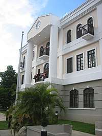
- Inter-American University of Puerto Rico
- Church San Germán de Auxerre
- La Barrica, Original Spanish Tavern. Circa 1847
The urban center of San Germán is mainly composed of Spanish colonial houses. Many have been restored and conserve their Spanish look while other houses are somewhat abandoned and in poor condition. There are ongoing projects employing public and private funding to preserve and restore many houses and monuments and to maintain San Germán's colonial era look.
Culture
Festivals and events
- Patron Celebrations (St. Germain d'Auxerre and Santa Rosa de Lima) - July
- Festival de la Pana - July
- Anón Festival - September
- Christmas Festival - December
- Christmas Parade - Early December
- Patron Celebrations (The Virgin of the Rosary) — Celebrated in San Germán's Ward, Rosario Poblado, which borders Mayagüez.
Sports
San Germán is home to one of Puerto Rico's oldest basketball franchises, dating back to the 1930s, the San Germán Athletics (los Atléticos de San Germán), nicknamed "The Orange Monster". Many glories of Puerto Rican basketball have played in San Germán, a city that is also known as "The Crib of Puerto Rican Basketball". Some of those players are Arquelio Torres, José "Piculín" Ortiz, Eddie Casiano, Nelson Quiñones, Elías "Larry" Ayuso, Christian Dalmau, and so many others. Their home court is The Arquelio Torres Ramírez Court, which houses approximately 5,000 fans.
The Athletic's fan base is most commonly referred to as their sixth man, or "The Orange Monster". This is because for a visiting team it's extremely hard to win in San Germán due to how vigorous and "into" the game the fans are.
The Athletics have been to 26 National Superior Basketball (BSN) Finals, of which one was cancelled (1953) due to confiscation because of a fight between players from San Germán and the Ponce Lions, giving birth to Puerto Rican basketball's most intense rivalry.
Championships (14): 1932, 1936, 1939, 1941, 1942, 1943, 1947, 1948, 1949, 1950, 1985, 1991, 1994, 1997 Sub-Championships (11): 1931, 1933, 1936, 1938, 1940, 1954, 1955, 1956, 1957, 1965, 1986
Economy
Agriculture
The area around San Germán grows fruits (banana, pineapple) and sugar cane on mid-scale. Dairy farms are also present in small scale. Some locals grow other produce on a small scale. Other industries in the municipality include Baxter Serum Mfg., Cordis, Insertco (print shop for medical instructions inserts), Wallace Silversmiths de Puerto Rico, General Electric (production of circuit breakers) and several other companies in the service industry.
Business
Most businesses are located in or near the "downtown" area (San Germán Pueblo). Plaza del Oeste is the main shopping center.
Industry
Major employers of the city include Fresenius Kabi, CCL, Wallace International, General Electric and several business owners.
Motion pictures filmed In San Germán
- Act of Valor (2012) Which follows a Navy Seal squad on a covert mission to recover a kidnapped CIA Agent Morales (Roselyn Sánchez).
- Dinero Sangre (1986) In a banana republic a ruthless mercenary waits to make a killing in gold. Only two people stand in his way (Guy Ecker)
Demographics
| Historical population | |||
|---|---|---|---|
| Census | Pop. | %± | |
| 1900 | 20,246 | — | |
| 1910 | 22,143 | 9.4% | |
| 1920 | 23,848 | 7.7% | |
| 1930 | 23,768 | −0.3% | |
| 1940 | 26,473 | 11.4% | |
| 1950 | 29,553 | 11.6% | |
| 1960 | 27,667 | −6.4% | |
| 1970 | 27,990 | 1.2% | |
| 1980 | 32,922 | 17.6% | |
| 1990 | 34,962 | 6.2% | |
| 2000 | 37,105 | 6.1% | |
| 2010 | 35,527 | −4.3% | |
| U.S. Decennial Census[20] 1899 (shown as 1900)[21] 1910-1930[22] 1930-1950[23] 1960-2000[24] 2010[13] | |||
| Racial - (self-defined) San Germán, Puerto Rico - 2010 Census[25] | ||
|---|---|---|
| Race | Population | % of Total |
| White | 29,614 | 83.4% |
| Black/African American | 1,989 | 5.6% |
| American Indian and Alaska Native | 129 | 0.4% |
| Asian | 41 | 0.1% |
| Native Hawaiian Pacific Islander | 5 | 0.0% |
| Some other race | 2,992 | 8.4% |
| Two or more races | 727 | 2.1% |
Government
Like all municipalities in Puerto Rico, San Germán is administered by a mayor. The current mayor is Isidro A. Negrón Irizarry, from the Partido Popular Democrático Popular Democratic Party (PPD). Negrón was first elected in the 2000 general election.
The city belongs to the Puerto Rico Senatorial district IV, which is represented by two Senators. In 2012, María Teresa González and Gilberto Rodríguez were elected as District Senators.[26]
Transportation
There are 44 bridges in San Germán.[27]
Symbols
Flag
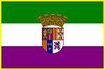
Green - The Episcopal dignity and also the color of the Shield of Christopher Columbus and his son, don Diego Colón, Viceroy of the Indies, who named the city in honor of Germana de Foix.
White - The purity of the blood of the great families who colonized San Germán.
Purple - Color of the Shield of Juan Ponce de León, first governor of Puerto Rico.
Coat of arms
First Quarter: The Mitre and the Staff in a green field represent St. Germain of Auxerre, the Patron Saint of the city.
Second Quarter: The second quarter exhibits the arms of the Kingdoms of Aragón and Sicily, where don Fernando the Catholic reigned.
Third Quarter: In this quarter the arms combine with the County of Foix and the Kingdom of France, which constitute the family shields of Germaine de Foix whose name is perpetuated as the name of the city of San Germán.
Fourth Quarter: Is Ponce de León's shield, The Crown: Is a civic or municipal standard and is used as a stamp for towns and cities; San Germán was assigned five towers to denote that this population formally obtained the title of city from the Spanish crown in the nineteenth century.
Education
San Germán has 15 public schools: 8 elementary schools, 1 middle school, 4 second units and 2 high schools:
- Amina Tió de Malaret (Elementary)
- Antonia Martínez (Elementary)
- Bartolomé de las Casas (Elementary)
- Carmen Borrás Batistini (Elementary)
- Georgina Alvarado (Elementary)
- Henry Wadsworth Longfellow (Elementary)
- Herminia C. Ramírez (Elementary)
- Mariano Abril (Elementary)
- Julio Víctor Guzmán (Middle)
- Luis Muñoz Rivera (Second Unit)
- Federico Degetau (Second Unit)
- Francisco Mariano Quiñones (Second Unit)
- Galo Rosado (Second Unit)
- Laura Mercado (High School)
- Lola Rodríguez de Tió (High School)
It also has several private schools, such as Colegio San José, Academia Sangermeña and Academia Presbiteriana.
The main campus of the Inter-American University of Puerto Rico is located adjacent to the downtown area of San Germán. It was founded in 1912 as the Polytechnical Institute of Puerto Rico, the first private university on the island.
Notable Puerto Ricans from San Germán
- PFC Joseph R. (José) Martínez destroyed a German infantry unit and tank in Tunisia, during World War II, by providing heavy artillery fire, saving his platoon from being attacked in the process. He was awarded the Distinguished Service Cross, second only to the Medal of Honor, by General George S. Patton, thus becoming the first Puerto Rican recipient of said military decoration.[28]
- Ubaldino Ramírez de Arellano — Senator
- Lola Rodríguez de Tió — poet, author of the original lyrics of Puerto Rico's national anthem, La Borinqueña, and pro-independence advocate
- Benjamín Marcantoni - opera singer
- Benicio del Toro — Award-winning actor
- Francisco Mariano Quiñones — Abolitionist and politician
- Samuel R. Quiñones — Longest-serving President of the Puerto Rico Senate, serving for twenty years.
Gallery
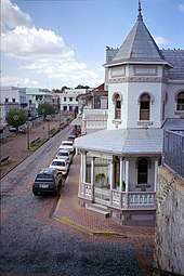 Street in San Germán
 San Germán
See also
- List of Puerto Ricans
- History of Puerto Rico
- National Register of Historic Places listings in San Germán, Puerto Rico
- Did you know-Puerto Rico?
References
- Bureau, U. S. Census. "American FactFinder - Results". Fact Finder on US Census Gov. Archived from the original on 2019-03-30. Retrieved 2019-03-02.
- "Página Oficial de Municipio Autónomo de San Germán, Puerto Rico". Archived from the original on 2008-06-05. Retrieved 2008-07-23.
- Historia general y natural de las Indias, islas y tierra-firme del mar oceano (in Spanish). 23 October 1851. p. 466. Archived from the original on 23 May 2017. Retrieved 6 November 2019 – via Internet Archive.
- https://welcome.topuertorico.org/history.shtml
- Fuson, Robert (2000). Juan Ponce De Leon and the Spanish Discovery of Puerto Rico and Florida. Blacksburg, Virginia: McDonald & Woodward. p. 79. ISBN 0-939923-82-3.
- Thomas, Hugh (2003). Rivers of Gold: The Rise of the Spanish Empire. London: Weidenfeld & Nicolson. p. 231. ISBN 0-297-64563-3.
- Floyd, Troy (1973). The Columbus Dynasty in the Caribbean, 1492-1526. Albuquerque: University of New Mexico Press. p. 139.
- "Revista/review Interamericana (San German, Puerto Rico)" (in Spanish). VII. Inter American University Press. 1 January 1957: 640. Cite journal requires
|journal=(help) - "San Germán Municipality". enciclopediapr.org. Fundación Puertorriqueña de las Humanidades (FPH). Archived from the original on 2019-04-04. Retrieved 2019-03-20.
- "Preliminary Locations of Landslide Impacts from Hurricane Maria, Puerto Rico". USGS Landslide Hazards Program. USGS. Archived from the original on 2019-03-03. Retrieved 2019-03-03.
- "Preliminary Locations of Landslide Impacts from Hurricane Maria, Puerto Rico" (PDF). USGS Landslide Hazards Program. USGS. Archived (PDF) from the original on 2019-03-03. Retrieved 2019-03-03.
- Gwillim Law (20 May 2015). Administrative Subdivisions of Countries: A Comprehensive World Reference, 1900 through 1998. McFarland. p. 300. ISBN 978-1-4766-0447-3. Retrieved 25 December 2018.
- Puerto Rico:2010:population and housing unit counts.pdf (PDF). U.S. Dept. of Commerce Economics and Statistics Administration U.S. Census Bureau. 2010. Archived (PDF) from the original on 2017-02-20. Retrieved 2018-12-26.
- "US Census Barrio-Pueblo definition". Fact Finder. US Census. Archived from the original on 13 May 2017. Retrieved 5 January 2019.
- "Agencia: Oficina del Coordinador General para el Financiamiento Socioeconómico y la Autogestión (Proposed 2016 Budget)". Puerto Rico Budgets (in Spanish). Retrieved 28 June 2019.
- Rivera Quintero, Marcia (2014), El vuelo de la esperanza: Proyecto de las Comunidades Especiales Puerto Rico, 1997-2004 (first ed.), San Juan, Puerto Rico Fundación Sila M. Calderón, ISBN 978-0-9820806-1-0
- "Leyes del 2001". Lex Juris Puerto Rico (in Spanish). Retrieved 24 June 2020.
- Rivera Quintero, Marcia (2014), El vuelo de la esperanza:Proyecto de las Comunidades Especiales Puerto Rico, 1997-2004 (Primera edición ed.), San Juan, Puerto Rico Fundación Sila M. Calderón, p. 273, ISBN 978-0-9820806-1-0
- Archived 2014-01-08 at the Wayback Machine, The Weather Channel accessed 8 January 2014.
- "U.S. Decennial Census". United States Census Bureau. Archived from the original on February 13, 2020. Retrieved September 21, 2017.
- "Report of the Census of Porto Rico 1899". War Department Office Director Census of Porto Rico. Archived from the original on July 16, 2017. Retrieved September 21, 2017.
- "Table 3-Population of Municipalities: 1930 1920 and 1910" (PDF). United States Census Bureau. Archived (PDF) from the original on August 17, 2017. Retrieved September 21, 2017.
- "Table 4-Area and Population of Municipalities Urban and Rural: 1930 to 1950" (PDF). United States Census Bureau. Archived (PDF) from the original on August 30, 2015. Retrieved September 21, 2014.
- "Table 2 Population and Housing Units: 1960 to 2000" (PDF). United States Census Bureau. Archived (PDF) from the original on July 24, 2017. Retrieved September 21, 2017.
- Bureau, U. S. Census. "American FactFinder - Results". Fact Finder. Archived from the original on 2015-11-20. Retrieved 2019-03-02.
- Elecciones Generales 2012: Escrutinio General Archived 2013-01-15 at the Wayback Machine on CEEPUR
- "San Germán Bridges". National Bridge Inventory Data. US Dept. of Transportation. Archived from the original on 21 February 2019. Retrieved 20 February 2019.
- "Log In ‹ Home of Heroes — WordPress". Home of Heroes. Archived from the original on 2019-03-05. Retrieved 2019-03-02.
External links
| Wikimedia Commons has media related to San Germán, Puerto Rico. |
| Wikisource has the text of the 1911 Encyclopædia Britannica article San German. |
- San German, Puerto Rico
- San Germán and its barrios, United States Census Bureau

- Official Webpage of the San German Atleticos
- Welcome to Puerto Rico! San German Map
- Welcome to Puerto Rico! San Germán
- San German Municipality on Facebook
Places adjacent to San Germán, Puerto Rico | ||||||||||
|---|---|---|---|---|---|---|---|---|---|---|
| ||||||||||