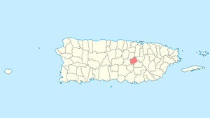
Comerío, Puerto Rico
Comerío (Spanish pronunciation: [komeˈɾi.o]) is a municipality of Puerto Rico located in the center-eastern region of island, north of Aibonito; south of Naranjito and Bayamón; east of Barranquitas; and west of Cidra and Aguas Buenas. Comerío is spread over 7 wards and Comerío Pueblo (the downtown area and the administrative center of the city). It is part of the San Juan-Caguas-Guaynabo Metropolitan Statistical Area.
Comerío Municipio Autónomo de Comerío | |
|---|---|
Town and Municipality | |
 | |
 Flag | |
| Nicknames: "La Perla de Plata", "Pueblo de los Guabaleros" | |
| Anthem: "Con alma henchida de amor y ensueño" | |
 Location of Comerío in Puerto Rico | |
| Coordinates: 18°13′05″N 66°13′34″W | |
| Commonwealth | |
| Founded | June 12, 1826 |
| Government | |
| • Mayor | José A. "Josian" Santiago Rivera (PPD) |
| • Senatorial dist. | 6 - Guayama |
| • Representative dist. | 29 |
| Area | |
| • Total | 28.24 sq mi (73.13 km2) |
| • Land | 28 sq mi (73 km2) |
| • Water | 0.05 sq mi (.13 km2) |
| Population (2010) | |
| • Total | 20,778 |
| • Density | 740/sq mi (280/km2) |
| Demonym(s) | Comerieños |
| Time zone | UTC−4 (AST) |
| Zip code | 00782 |
| Area code | +1 (spec. +1-787 and +1-939) |
| Major routes | |
| Website | www |
History
Comerío was founded on June 12, 1826. Originally named "Sabana del Palmar", but later changed to Comerío, named after a local Taino Cacique (Chief) Comerio.[1]
In 1854, nearly 1000 acres (1000 cuerdas) of land were being used for agriculture. In 1894, there was one sugar and two coffee plantations (estates) in Comerío.[2] In the early 20th century, Comerio residents, had a short but legendary territory war with residents of the city of Barranquitas.
Hurricane Maria
.jpg)
Hurricane Maria on September 20, 2017 triggered numerous landslides in Comerío with the significant amount of rainfall.[3][4] After the hurricane, the National Guard from Ohio were tasked with restoring water purification systems for the people of Comerío.
Geography
The rivers located in Comerío are Río de la Plata and Río Hondo.[5]
Barrios

Like all municipalities of Puerto Rico, Comerío is subdivided into barrios. The municipal buildings, central square and large Catholic church are located in a small barrio referred to as "el pueblo", near the center of the municipality.[6][7][8][9]
Sectors
Barrios (which are like minor civil divisions)[10] in turn are further subdivided into smaller local populated place areas/units called sectores (sectors in English). The types of sectores may vary, from normally sector to urbanización to reparto to barriada to residencial, among others.[11][12][13]
Special Communities
Of the 742 places on the list of Comunidades Especiales de Puerto Rico, the following barrios, communities, sectors, or neighborhoods were in Comerio: Barriada Cielito, Sector Villa Brava in Piñas Abajo, El 26 in Palomas Abajo, El Higüero in Palomas Abajo, El Verde in Naranjo, La Juncia in Rio Hondo II, La Pietra Cedrito, Río Hondo, and Vuelta del Dos.[14][15]
Tourism
Landmarks and places of interest
Some of the landmarks of Comerío include:[16]
- La Tiza Peak
- La Mora Caves
- La Plata River
- Las Pailas
- Los Pilones
- Media Luna Recreation Park
- Tobacco Warehouse
- Town Square
- El Salto Hydroelectric Dams 1 and 2
Economy
Agriculture
- Tobacco (not as predominant lately). Comerío was known as "El Pueblo del Tabaco" (Tobacco Town), and its original flag had a tobacco plant in its center.[17]
Culture
Festivals and events
- Spring Carnival - April
- La Mora Cave Festival - June 1,2,3
- Jíbaro Festival - June
- El Jobo Festival - July
- Patron Festivities - August
- San Andrés Apóstol Festivities - November
- El Seco Marathon - December
- Christmas Fantasy - December
Religion
First Methodist Church of Comerío was founded in 1904.
Demographics
| Population during Spanish Colonial Times | ||
|---|---|---|
| Year | Pop. | ±% |
| 1846 | 2,533 | — |
| 1860 | 4,803 | +89.6% |
| 1862 | 5,543 | +15.4% |
| 1865 | 5,463 | −1.4% |
| 1866 | 5,514 | +0.9% |
| 1867 | 5,600 | +1.6% |
| 1874 | 5,525 | −1.3% |
| 1877 | 6,190 | +12.0% |
| 1881 | 6,319 | +2.1% |
| 1887 | 6,739 | +6.6% |
| 1896 | 6,680 | −0.9% |
| 1897 | 6,623 | −0.9% |
| P.R. Office of the Historian (1949)[2] | ||
| Historical population | |||
|---|---|---|---|
| Census | Pop. | %± | |
| 1900 | 8,249 | — | |
| 1910 | 11,170 | 35.4% | |
| 1920 | 14,708 | 31.7% | |
| 1930 | 16,715 | 13.6% | |
| 1940 | 18,539 | 10.9% | |
| 1950 | 17,966 | −3.1% | |
| 1960 | 18,583 | 3.4% | |
| 1970 | 18,819 | 1.3% | |
| 1980 | 18,212 | −3.2% | |
| 1990 | 20,265 | 11.3% | |
| 2000 | 20,002 | −1.3% | |
| 2010 | 20,778 | 3.9% | |
| U.S. Decennial Census[18] 1899 (shown as 1900)[19] 1910-1930[20] 1930-1950[21] 1960-2000[22] 2010[8] | |||
Mestizos are typically born in this region due to tainos occupying this area heavily.
Government
All municipalities in Puerto Rico are administered by a mayor, elected every four years. The current mayor of Comerío is José A. Santiago, of the Popular Democratic Party (PPD). He was elected at the 2000 general elections.
The city belongs to the Puerto Rico Senatorial district VI, which is represented by two Senators. In 2012, Miguel Pereira Castillo and Angel M. Rodríguez were elected as District Senators.[23]
Symbols
Flag
Quartered in cross, of green and white, and superimposed the right superior quarter is an anchored yellow cross.[1]
Coat of arms
The Comerío coat of arms is made up quarters (4) bearing what is known as an escutcheon of displays a shield in the center. There's a green field with a golden cross in the left quarter which represents Holy Christ the Healer, the patron of the town. Green stripes on a silver field are on the lower left quarter, symbolizing the Comerío falls and the La Plata River. Three royal palms in the right quarter to remember the original name of the town, and an undulating line symbolizes the mist that often covers the town. A crown with Taino motifs represents the cacique. The tobacco plant is a reminder of what was once an important part of the economic activity of the municipality. Inscribed with “the pearl of La Plata” a reference is made to the location of Comerío, on the banks of the La Plata River and the turreted castle which is a symbol of municipalities of Puerto Rico.[1]
Transportation
Public bus from Bayamón to Comerío at Centro de Estacionamiento de Bayamón is the main public transportation.
There are 16 bridges in Comerío.[24]
Notable Comerieños
- Celestino J. Pérez - Pharmacist, lawyer and elected legislator
- Claudio Torres - Composer
- Juana Colón (1886–1967) - Founder of the Socialist Party in Comerío
- Manuel A. Pérez (1890–1951) - Professor
- María Arroyo - Teacher, President of the Teachers Association and Senator
- Enrique Pérez Santiago - Hematologist
- Arturo Perez, Mayor of Comerio elected by Partido Liberal
Gallery
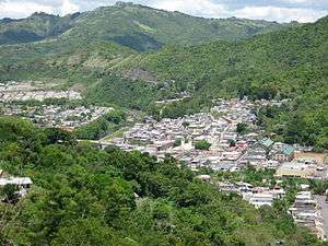
 Mountaintop view looking north from 18.21512N, 66.21719W
See also
- List of Puerto Ricans
- History of Puerto Rico
- Did you know-Puerto Rico?
References
- "Comerío Municipality Founding and History". enciclopediapr.org. Archived from the original on 14 February 2019. Retrieved 14 February 2019.
- Puerto Rico. Office of Historian (1949). Tesauro de datos historicos: indice compendioso de la literatura histórica de Puerto Rico, incluyendo algunos datos inéditos, periodísticos y cartográficos (in Spanish). Impr. del Gobierno de Puerto Rico. p. 191. Retrieved 4 January 2020.
- "Preliminary Locations of Landslide Impacts from Hurricane Maria, Puerto Rico". USGS Landslide Hazards Program. USGS. Archived from the original on 2019-03-03. Retrieved 2019-03-03.
- "Preliminary Locations of Landslide Impacts from Hurricane Maria, Puerto Rico" (PDF). USGS Landslide Hazards Program. USGS. Archived (PDF) from the original on 2019-03-03. Retrieved 2019-03-03.
- "Comerío Municipality General Information, Geography". enciclopediapr.org. Archived from the original on 14 February 2019. Retrieved 14 February 2019.
- Picó, Rafael; Buitrago de Santiago, Zayda; Berrios, Hector H. Nueva geografía de Puerto Rico: física, económica, y social, por Rafael Picó. Con la colaboración de Zayda Buitrago de Santiago y Héctor H. Berrios. San Juan Editorial Universitaria, Universidad de Puerto Rico,1969. Archived from the original on 2018-12-26. Retrieved 2019-01-04.
- Gwillim Law (20 May 2015). Administrative Subdivisions of Countries: A Comprehensive World Reference, 1900 through 1998. McFarland. p. 300. ISBN 978-1-4766-0447-3. Retrieved 25 December 2018.
- Puerto Rico:2010:population and housing unit counts.pdf (PDF). U.S. Dept. of Commerce Economics and Statistics Administration U.S. Census Bureau. 2010. Archived (PDF) from the original on 2017-02-20. Retrieved 2019-01-04.
- "Map of Comerío at the Wayback Machine" (PDF). Archived from the original (PDF) on 2018-03-24. Retrieved 2018-12-29.
- "US Census Barrio-Pueblo definition". factfinder.com. US Census. Archived from the original on 13 May 2017. Retrieved 5 January 2019.
- "Agencia: Oficina del Coordinador General para el Financiamiento Socioeconómico y la Autogestión (Proposed 2016 Budget)". Puerto Rico Budgets (in Spanish). Retrieved 28 June 2019.
- Rivera Quintero, Marcia (2014), El vuelo de la esperanza: Proyecto de las Comunidades Especiales Puerto Rico, 1997-2004 (first ed.), San Juan, Puerto Rico Fundación Sila M. Calderón, ISBN 978-0-9820806-1-0
- "Leyes del 2001". Lex Juris Puerto Rico (in Spanish). Retrieved 24 June 2020.
- Rivera Quintero, Marcia (2014), El vuelo de la esperanza: Proyecto de las Comunidades Especiales Puerto Rico, 1997-2004 (1st ed.), San Juan, Puerto Rico Fundación Sila M. Calderón, p. 273, ISBN 978-0-9820806-1-0
- "Comunidades Especiales de Puerto Rico" (in Spanish). 8 August 2011. Archived from the original on 24 June 2019. Retrieved 24 June 2019.
- "Comerío Municipality Places of Interest". enciclopediapr.org. Archived from the original on 14 February 2019. Retrieved 14 February 2019.
- Comerio, Puerto Rico. Archived 2011-02-01 at the Wayback Machine Flags of the world. Retrieved 8 July 2012.
- "U.S. Decennial Census". United States Census Bureau. Archived from the original on February 13, 2020. Retrieved September 21, 2017.
- "Report of the Census of Porto Rico 1899". War Department Office Director Census of Porto Rico. Archived from the original on July 16, 2017. Retrieved September 21, 2017.
- "Table 3-Population of Municipalities: 1930 1920 and 1910" (PDF). United States Census Bureau. Archived (PDF) from the original on August 17, 2017. Retrieved September 21, 2017.
- "Table 4-Area and Population of Municipalities Urban and Rural: 1930 to 1950" (PDF). United States Census Bureau. Archived (PDF) from the original on August 30, 2015. Retrieved September 21, 2014.
- "Table 2 Population and Housing Units: 1960 to 2000" (PDF). United States Census Bureau. Archived (PDF) from the original on July 24, 2017. Retrieved September 21, 2017.
- Elecciones Generales 2012: Escrutinio General Archived December 3, 2012, at the Wayback Machine on CEEPUR
- "Comerio Bridges". National Bridge Inventory Data. US Dept. of Transportation. Archived from the original on 20 February 2019. Retrieved 19 February 2019.
Further reading
- Levy, Teresita A. (2007). The History of Tobacco Cultivation in Puerto Rico, 1899--1940. ProQuest. ISBN 9780549267843.
External links
- Puerto Rico Government Directory - Comerío
- Municipalities at enciclopediapr.org
- Comerío, Puerto Rico (by Raphael Angelo)