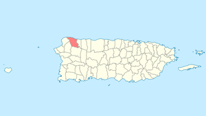
Isabela, Puerto Rico
Isabela (Spanish pronunciation: [isaˈβela]) is a municipality of Puerto Rico) located in the north-western region of the island, north of San Sebastián; west of Quebradillas; and east of Aguadilla and Moca. It is named in honor of Isabella I of Castile. Isabela is spread over 13 wards and Isabela Pueblo, which is the downtown area and administrative center. It is a principal part of the Aguadilla-Isabela-San Sebastián Metropolitan Statistical Area.
Isabela Municipio de Isabela | |
|---|---|
Town and Municipality | |
 | |
 Flag  Coat of arms | |
| Nicknames: "El Jardín del Noroeste", "El Pueblo de los Quesitos de Hoja" | |
| Anthem: "Isabela - Danza " | |
 Location of Isabela in Puerto Rico | |
| Coordinates: 18°30′47″N 67°04′12″W | |
| Commonwealth | |
| Founded | 1725 |
| Government | |
| • Mayor | Carlos Delgado Altieri (PPD) |
| Area | |
| • Total | 91.95 sq mi (238.15 km2) |
| • Land | 55.36 sq mi (143.39 km2) |
| • Water | 36.58 sq mi (94.75 km2) |
| Population (2010) | |
| • Total | 45,631 |
| • Density | 500/sq mi (190/km2) |
| Demonym(s) | Isabelinos |
| Time zone | UTC−4 (AST) |
| Zip code | 00662 |
| Major routes | |
| Website | www |

Nicknames
The town is known as the "Jardín del Noroeste", the "Garden of the Northwest", because of the many wild flowers in its landscape. It is also known as "El Pueblo de los Quesitos de Hoja", the "Town of Leaf Cheeses," for its production of a typical fresh white cheese wrapped in banana plant leaves, reputed to be the best. It is also known as la Ciudad de los Gallitos or the "City of the Fighting Cocks." Since the 18th century, cock fighting was very common throughout the island, and the town became famous and well known for the quality of its fighting cocks and special breeding and training techniques used by its people.[1]
History
Foundation
The chief Mabodamaca, one of the most important chieftains of the Island of Borinquen (name for the island of Puerto Rico) during the first decades of the 16th century, ruled the region of the 'Guajataca' (Taíno name for the northwestern region of Puerto Rico) where Isabela was founded. Although the actual date of the origins of the first Spanish settlement is not precisely known, a small settlement/hermitage is known to have existed by the end of the 17th century or beginning of the 18th century in a great extension of land into what encompass today the municipalities of Isabela, Camuy and Quebradillas. The settlement was bordered to the east with the shoreline of the Guajataca River and was located on the grounds of an earlier Taíno settlement.
Around 1725, José Antonio de Mendizábal y Azares, Governor of the Island of Puerto Rico granted authorization to base a population on the existing hermitage/village. Its given name, San Antonio de La Tuna, derives from the avocation of the Spanish settlers to the saint San Antonio de Padua and in honor of a wild cactus growing in the region (Tuna is the Spanish name for cactus). At the end of the 18th century San Antonio de la Tuna had a church, more than sixty houses, and almost 1,200 inhabitants, which was a considerable population for those times.
Relocation
Prompted by economic and health factors, the decision to relocate the hermitage to a more favorable location was pursued. Around 1818, the village obtained authorization from then Governor Salvador Meléndez to transfer the population to a new location closer to the coast. Meléndez approved the transfer request and a new town was founded the following year on May 21, 1819. In the same year the construction of the church began, and was finished in 1824. In 1918 the church was damaged during a strong earthquake that affected the western region of the island, it was rebuilt soon after.
Hurricane Maria
In September 2017 thousands of people were evacuated from their homes in Isabela when Hurricane Maria caused structural damage to the nearby Guajataca Reservoir.[2]
Demographics
| Historical population | |||
|---|---|---|---|
| Census | Pop. | %± | |
| 1900 | 14,888 | — | |
| 1910 | 16,852 | 13.2% | |
| 1920 | 19,809 | 17.5% | |
| 1930 | 23,068 | 16.5% | |
| 1940 | 25,842 | 12.0% | |
| 1950 | 29,113 | 12.7% | |
| 1960 | 28,754 | −1.2% | |
| 1970 | 30,430 | 5.8% | |
| 1980 | 37,435 | 23.0% | |
| 1990 | 39,147 | 4.6% | |
| 2000 | 44,444 | 13.5% | |
| 2010 | 45,631 | 2.7% | |
| Est. 2016 | 42,744 | [3] | −6.3% |
| U.S. Decennial Census[4] 1899 (shown as 1900)[5] 1910-1930[6] 1930-1950[7] 1960-2000[8] 2010[9] 2016[3] | |||
According to the 2010 Census, there were 45,631 people in the city. This represents an increase of more than 1,000 from the 2000 Census.[10] The population density was 825.1 inhabitants per square mile (318.6/km2). There were 21,267 housing units. 23.8% of residents were under the age of 18 and 14.7% were 65 years of age or older. The gender make up was 48.7% male and 51.3% female.
As a whole, Puerto Rico is populated mainly by people from a Creole (born on the Island of European descent) or Spanish and European descent, with small groups of African and Asian people. Statistics taken from the 2000 census shows that 83.6% of Aguadillanos have Spanish or white origin, 5.0% are black, 0.2% are Amerindian, 0.2% Asian, 0.1% Native Hawaiian/Pacific Islander, 8.2% were Some other race, 2.8% Two or more races.
Geography
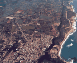
Isabela is a hybrid town of sorts, with the rarity of being a coastline city that has beaches but is also known for its mountains (with peaks of over 1,000 ft [300 m] above sea level), rivers (surface and submarine), lakes, caves (surface and submarine), cliffs, coastal flats and forests (Tropical and Mangroves).[11]
Geographically, the municipality of Isabela belongs to the Northern Coastal Plains. Running through the south, the Aymamón mountains, a prolongation of the Jaicoa Mountain Range that begins in the neighboring town of Aguadilla, boasts peaks of over 1,000 feet (300 m) above sea level. The most prominent hills that are part of these mountains are La Bandera (Galateo Alto ward) at 1,207 ft (368 m); La Silla (Arenales Alto ward) at 1,106 ft (337 m); El Sombrero (in Galateo Alto) at 1,083 feet (330 m); Indio (Planas ward) at 1,017 feet (310 m); and Monte Encantado (in Arenales Altos) at 919 feet (280 m) of elevation above sea level. The central part of the territory consists mostly of flatlands, the mountains do not surpass 656 feet (200 m) in height and the coastline flats (Bajuras) are slightly above sea level.
Barrios
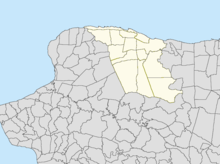
Like all municipalities of Puerto Rico, Isabela is subdivided into barrios. The municipal buildings, central square and large Catholic church are located in a barrio referred to as "el pueblo".[12][13][9][14]
Sectors
Barrios (which are like minor civil divisions)[15] in turn are further subdivided into smaller local populated place areas/units called sectores (sectors in English). The types of sectores may vary, from normally sector to urbanización to reparto to barriada to residencial, among others.[16][17][18]
Special Communities
Of the 742 places on the list of Comunidades Especiales de Puerto Rico, the following barrios, communities, sectors, or neighborhoods were in Isabela: Cerro del Sombrero in Arenales Alto, Pueblo Nuevo in Arenales Bajos, Barriada Corchado, Comunidad Poncito in Llanadas, Sector Las Parcelas and Sector Pastillo and Sector San Antonio de la Tuna in Coto, Sector Capiro and Sector Corea in Galateo Alto, Sector El Ramal in Guerrero, Parcelas Nuevas and Parcelas Viejas in Mora Guerrero, Comunidad Cristal, Sector Planas, Media Cuerda, Parcelas Jobos, Santa Bárbara, Sector El Cañón, Sector El Verdum, Sector La Mantilla, Sector La Marina, Sector La Mina, Sector La Sierra, Tocones, and Villa Pesquera.[19][20]
Tourism

One of Isabela's current main industries is tourism, because it's a coastal city with several beautiful beaches, outstanding panoramic views and other diverse attractions such as its rainforest, rivers, lake, cordillera mountains, submarine rivers and caves and archaeological sites among other things. It is visited by many local tourists as well as those seeking some sun and fun from the United States mainland and other countries.
Landmarks and places of interest
There are 12 beaches in Isabela including Jobos.[21] The main attractions of Isabela include:
- El Pozo Brujo (The Bewitched Well)
- Jobos Beach & Pozo de Jacinto
- Montones Beach
- San Antonio de la Tuna Ruins
- Punta Sardina
- La Poza de Punta Sandina
- La Princesa Beach & Blow Hole
- Centro Empresarial Playero - Villa Pesquera
- Shacks Beach
- Río Guajataca
- Guajataca Tunnel
- La Cara del Indio (The Indian's Face)
- La Posita de Teodoro
- Middle Beach
- La Posita de Montones
- Casa Parroquial
- Parroquia San Antonio de la Tuna
- La Posita de la Princesa
- Shore Island Beach
- Paseo Lineal
- San Antonio de la Tuna Museum
- La Pocita de Isabela (Poza de Teodoro)
- La Cueva de las Golondrinas
- Cueva los Vientos (Bosque Guajataca)
- Photo Museum of Isabela
- Alcaldia de Isabela
- The Pink House (Casa Rosada), (Demolished in 2014 by the Municipality to be transformed into a museum) Lewiz Menz
- Bajura Beach also known as Shacks Beach known for the best wind/sail surfing in the world. In front of the Villa Tropical Apartments is the "Blue Hole" Coral Reef. A favorite for snorkelers, scuba and free divers and underwater caverns enthusiasts.
Economy
Agriculture

The early economy of the hermitage had been based mainly on cattle [ranching], its derivative products and hogs products, but trading was limited due to many factors: its inland location and topography. The settlement was posted above a hill overlooking the river (now river Guajataca) which made it difficult to use the river as a trading route, as did the location's propensity to disease and outbreaks.
After the transfer to the present Isabela location the economic realities that resulted from the new land and property opportunities that were readily available, the healthier environment formed due to the wide open plains and prevalent northern winds, and the proximity to the coast and the natural sea port at the bay of 'Punta Sardina' prompted for the diversification of the agricultural products and an increase in trade. The cultivation of sugar cane, coffee, tobacco, cotton, Cassava/yuca, coconut and other fruits was stimulated further. Isabela continued to flourish until recent years due to the island's economic crisis, the closing of important factories and the rising crime rate.
Industry
Isabela also has a hi-tech plant, a higher education institution, a world-renowned agricultural research center and a major shopping center, Plaza Isabela.[22]
Culture
Festivals and events
- Fiesta de Reyes Isabelinos - January 5,6 Festival organized by La Casa de la Cultura Isabelina Inc (non profit cultural organization) honoring the wiseman (Reyes Magos) tradition represented by the "Reyes Cantores Isabelinos".
- Isabelino Fighting Cock Festivities - February
- Puerto Rock Steady Music Festival - May
- Weave Festival - May
- Kite Festival - May
- Patron Festivities - June
- Isabela Muscle Cars Auto Show - August
- Isabela Tango Fest - June - 3 days of Tango.
- Las Noches de la Puertorriqueñidad del colegio San Antonio - November[23]
- Feria de Autos Clasicos y Antiguos del Noroeste Inc. - November
- Isabela Has Flavor - November
- Innocent Saints Day - December
Sports
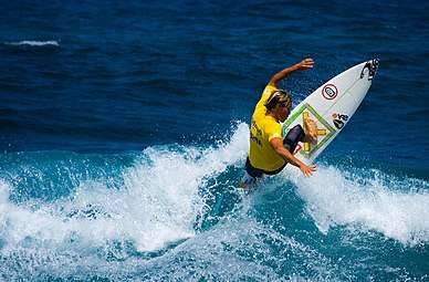
Isabela is also well known for its world-class surfing spots, and hosted two World Cup Surfing Championships, as well as some of the Rip Curl Pro competitions.
Isabela had a basketball team that played at the Jose "Buga" Abreu Coliseum, the Isabela Roosters ("Gallitos de Isabela"). The team had average success. In 1987, one of its superstars, Frankie Torruella, was diagnosed with heart disease, and the trading of another star player, Edwin Pellot, to the Coamo team, hastened the team's fallout. In 1984, the team lost the championship, four games to two, to the Canovanas Indians team ("Indios de Canóvanas"). Between the mid-1970s and mid-1980s, the Bantams were serious championship contenders. In the late 1970s their star player, Mickey Coll, died in a motorcycle accident. The team's first home court was named after him. The Bantams where Isabela's home team until October 2005 when they moved the franchise to Guaynabo. The Playeras, a female volleyball team, played in Isabela for 2 seasons until they also moved to Aguadilla becoming Las Divas.
The Isabela Muscle Cars Club, celebrating annual events since 2002 is a popular event in Isabela. On August 28, 2016 the club celebrated their 15th Anniversary at the Coliseum Jose "Buga" Abreu.
The town also has its own classic car club, called "Club de Autos Clasicos y Antiguos del Noroeste" (Classic and Old Car Club from Northwest). They also celebrate their own Exhibition of Classic Cars at the coliseum in November.
The local basketball team was called the "Gallitos" ("Little Cocks," in reference to the slim, lightweight body of the fighting variety) due to the town's fame for quality fighting cocks. The name was translated literally into English as "Bantams", a variety of dwarf cocks.
The town has a cockfighting arena, traditionally called a gallera. Fights were customarily held on Sunday mornings, and the bets and stakes were controlled by the government of Puerto Rico. Prizes were paid based on the fighting record of the cocks. A law prohibiting cockfighting in the U.S. and its territories went into effect in early 2019.
Isabela has amateur baseball teams. Also, Isabela is well known for its Fine Step Horses ("Caballos de Paso Fino") and its world class board, wind and kite surfing spots.
Government
Like all municipalities in Puerto Rico, Isabela is administered by a mayor. The current mayor is Carlos Delgado Altieri, from the Popular Democratic Party (PPD). Delgado was elected at the 2000 general election.
The city belongs to the Puerto Rico Senatorial district IV, which is represented by two senators. In 2012, María Teresa González and Gilberto Rodríguez were elected as District Senators.[24]
Transportation
There are 5 bridges in Isabela.[25]
Symbols
Flag
Isabela's flag derives its design, colors and symbolism from its coat of arms. It consists of three horizontal stripes of equal width. The top and bottom stripe are yellow and the center one green. The coat of arms may be superposed on the green stripe in the center.
Coat of arms
The town's coat of arms, dated 1819, is divided an olive tree in its center, symbolizes the first inhabitants of Isabela and of the island of Puerto Rico, the Igneris Indians. The gold represents the Taíno Indians (they made extensive use of gold), who lived in this area about two hundred years before the discovery of the island. The gold bell represented in the center stripe between two cactus is a symbol of the town of San Antonio de la Tuna. The two cocks represent the bravery of the inhabitants and Isabela's famous fighting cocks. The horse represents the cattle wealth of the region and honors the fine step horses (Paso Fino) for which Isabela is famous. The coat of arms is embellished with a mural crown having three towers, the standard emblem at the time for formally established 'pueblos' (townships) under Spanish rule. A new coat of arms is shown here; it depicts a revised mural crown with five towers to represent a city, but historically, only 11 communities[26] in Puerto Rico were conferred this title under Spanish rule.
On the occasion of the celebration of 186 years of Isabela ur was necessary to adopt an ordinance to establish properly the historical veracity and heraldic elements of the emblazoned shield and official seal of the City of Isabela. The following information was drafted pursuant to Ordinance Number 3, series 2005-2006 and approved by the Municipal Legislature on August 5, 2005:
"The Mural Crown: Current mural crown that has the coat of Isabela has three towers. Due to population increase of over 50,000 inhabitants who had Isabela in this last decade, the HUD office in Washington DC, conferred status as a "city" to Isabela last year. Given this demographic reality and focused on the mural crown that represents the spirit of unity and growth of the inhabitants of our city of Isabela, we understand appropriate that the crown mural consists of "five" distinct towers that symbolize the passage from town to city."
See also
| Wikimedia Commons has media related to Isabela. |
- List of Puerto Ricans
- History of Puerto Rico
- Did you know-Puerto Rico?
References
- "Puerto Rico by Municipio - GCT-PH1. Population, Housing Units, Area, and Density: 2000". Archived from the original on 2020-02-12. Retrieved 2006-08-22.
- "El Nuevo Día". María, un nombre que no vamos a olvidar.[Maria, a name we'll never forget] (in Spanish).
- "Population and Housing Unit Estimates". United States Census Bureau. Retrieved September 21, 2017.
- "U.S. Decennial Census". United States Census Bureau. Archived from the original on February 13, 2020. Retrieved September 21, 2017.
- "Report of the Census of Porto Rico 1899". War Department, Office Director Census of Porto Rico. Archived from the original on July 16, 2017. Retrieved September 21, 2017.
- "Table 3-Population of Municipalities: 1930, 1920, and 1910" (PDF). United States Census Bureau. Archived (PDF) from the original on August 17, 2017. Retrieved September 21, 2017.
- "Table 4-Area and Population of Municipalities, Urban and Rural: 1930 to 1950" (PDF). United States Census Bureau. Archived (PDF) from the original on August 30, 2015. Retrieved September 21, 2014.
- "Table 2 Population and Housing Units: 1960 to 2000" (PDF). United States Census Bureau. Archived (PDF) from the original on July 24, 2017. Retrieved September 21, 2017.
- Puerto Rico:2010:population and housing unit counts.pdf (PDF). U.S. Dept. of Commerce, Economics and Statistics Administration, U.S. Census Bureau. 2010. Archived (PDF) from the original on 2017-02-20. Retrieved 2019-01-04.
- Población de Puerto Rico por Municipios, 2000 y 2010 Archived 2012-06-03 at the Wayback Machine on Elections Puerto Rico
- "Isabela Municipality". enciclopediapr.org. Fundación Puertorriqueña de las Humanidades (FPH). Archived from the original on 2019-10-12. Retrieved 2019-03-20.
- Picó, Rafael; Buitrago de Santiago, Zayda; Berrios, Hector H. Nueva geografía de Puerto Rico: física, económica, y social, por Rafael Picó. Con la colaboración de Zayda Buitrago de Santiago y Héctor H. Berrios. San Juan Editorial Universitaria, Universidad de Puerto Rico,1969. Archived from the original on 2018-12-26. Retrieved 2019-01-04.
- Gwillim Law (20 May 2015). Administrative Subdivisions of Countries: A Comprehensive World Reference, 1900 through 1998. McFarland. p. 300. ISBN 978-1-4766-0447-3. Retrieved 25 December 2018.
- "Map of Isabela at the Wayback Machine" (PDF). Archived from the original (PDF) on 2018-03-24. Retrieved 2018-12-29.
- "US Census Barrio-Pueblo definition". factfinder.com. US Census. Archived from the original on 13 May 2017. Retrieved 5 January 2019.
- "Agencia: Oficina del Coordinador General para el Financiamiento Socioeconómico y la Autogestión (Proposed 2016 Budget)". Puerto Rico Budgets (in Spanish). Retrieved 28 June 2019.
- Rivera Quintero, Marcia (2014), El vuelo de la esperanza: Proyecto de las Comunidades Especiales Puerto Rico, 1997-2004 (first ed.), San Juan, Puerto Rico Fundación Sila M. Calderón, ISBN 978-0-9820806-1-0
- "Leyes del 2001". Lex Juris Puerto Rico (in Spanish). Retrieved 24 June 2020.
- Rivera Quintero, Marcia (2014), El vuelo de la esperanza: Proyecto de las Comunidades Especiales Puerto Rico, 1997-2004 (1st ed.), San Juan, Puerto Rico Fundación Sila M. Calderón, p. 273, ISBN 978-0-9820806-1-0
- "Comunidades Especiales de Puerto Rico" (in Spanish). 8 August 2011. Archived from the original on 24 June 2019. Retrieved 24 June 2019.
- "Las 1,200 playas de Puerto Rico [The 1200 beaches of Puerto Rico]". Primera Hora (in Spanish). April 14, 2017. Archived from the original on December 12, 2019. Retrieved December 12, 2019.
- "fomentocomercialpr.com" (PDF). Archived from the original (PDF) on 2007-08-08. Retrieved 2006-08-26.
- "Archived copy". Archived from the original on 2019-10-18. Retrieved 2019-10-18.CS1 maint: archived copy as title (link)
- Elecciones Generales 2012: Escrutinio General Archived 2013-01-15 at the Wayback Machine on CEEPUR
- "Isabela Bridges". National Bridge Inventory Data. US Dept. of Transportation. Archived from the original on 20 February 2019. Retrieved 19 February 2019.
- "Areciboweb - Puerto Rico Isla Del Encanto". Archived from the original on 2010-02-21. Retrieved 2010-07-04.
Books
- Isabela Economy (18th Century)b- *Gu�a descriptiva Colección de Tesis: Tesis de maestros presentadas en el Departamento de Historia Universidad de Puerto Rico, Recinto de Rio Piedras: Colón, Maria Judith, Historia de Isabela vista a traves de su desarrollo urbano, 1750-1850. (1985), 288 pp.
External links
| Wikimedia Commons has media related to Isabela, Puerto Rico. |
- Isabela and its barrios, United States Census Bureau
- Isabela Municipality
- The northwest of Puerto Rico
- Puerto Rico Government Directory - Isabela