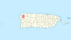
Moca, Puerto Rico
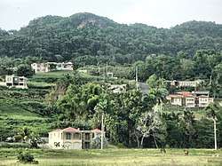
Moca (Spanish pronunciation: [ˈmoka]) is a municipality of Puerto Rico, located in the north-western region of the island, north of Añasco; southeast of Aguadilla; east of Aguada; and west of Isabela and San Sebastián. Moca is spread over 12 wards and Moca Pueblo (the downtown area and the administrative center of the ville). It is part of the Aguadilla-Isabela-San Sebastián Metropolitan Statistical Area.
Moca Municipio Autónomo de Moca | |
|---|---|
City and Municipality | |
 Moca, Puerto Rico | |
 Flag | |
| Nicknames: "Rebeldes", "Los Vampiros", "La Ciudad del Mundillo" | |
| Anthem: "Doce barrios, doce estrellas" | |
 Location of Moca in Puerto Rico | |
| Coordinates: 18°23′41″N 67°06′48″W | |
| Commonwealth | |
| Founded | June 22, 1772 |
| Government | |
| • Mayor | José E. Aviles Santiago (PNP) |
| • Senatorial dist. | 4 - Mayagüez |
| • Representative dist. | 17,18 |
| Area | |
| • Total | 133.0 km2 (51.4 sq mi) |
| • Land | 133 km2 (51 sq mi) |
| • Water | 0 km2 (0 sq mi) |
| Population (2010) | |
| • Total | 40,109 |
| • Density | 300/km2 (780/sq mi) |
| Demonym(s) | Mocanos |
| Time zone | UTC−4 (AST) |
| Zip code | 00676 |
| Major routes | |
The name of Moca comes from the tree Andira inermis whose beautiful pink/purple flowers expose their presence, which are very common in this region.
The Moca tree was officially adopted as the representative tree of the town on February 19, 1972. Moca is famous for its Mundillo lace. Mundillo is the Puerto Rican name for handmade bobbin lace. It is almost synonymous with the small town of Moca.
History

Moca known as La Capital del Mundillo' (The capital of lace), it is famous for its lace or Mundillo. It was founded by Don José de Quiñones on June 22, 1772. Diverse versions exist on the date of its foundation. Manuel de Ubeda and Delgado, in his "Isla de Puerto Rico. "Estudio histórico, geográfico y estadístico", published in San Juan in 1878, says to us that it was founded on 1774. On the other hand, Cayetano Coll y Toste, in the "Boletín histórico de Puerto Rico", maintains that it was founded on June 22, 1772.
On August 14, 1898, The United States Armed Forces entered and took the town of Moca finding no resistance. On August 8, 1898, after the Spanish–American War officially ended, Puerto Rico became a United States territory as an outcome of the Treaty of Paris of 1898.
Geography
.jpg)
Moca is located on the northwest.[1]
Localization: 18° 23'N and 67° 06'W of the Meridian of Greenwich. It is located in a small valley, in the skirts of "The Tuna" mountains, at 141 feet (43 m) above sea level.
Climate: Tropical with hardly noticeable seasonal changes. Temperatures throughout the year range highs between76 and 98 °F (24 and 37 °C) and lows between 50 and 75 °F (10 and 24 °C).
Hydrography: The Río Culebrinas crosses its territory from east to west, and its tributaries include the gorges of Los Gatos, Lassalle, de las Damas, Vieja, Los Romanes, the Morones, Higuillo, Chiquita, Yagruma, Echeverria, Aguas Frias, Las Marias, de los Méndez, La Caraíma, Grande, y Dulce. Cerro Moca, Monte El Ojo, Monte Mariquita of the Jaicoa Mountain Range
On May 16, 2010, Moca was the epicenter of a strong 5.8 earthquake. The earthquake was felt in the entire island and also in the Dominican Republic and the Virgin Islands. Damage was reported in various towns.
Hurricane Maria
Hurricane Maria on September 20, 2017 triggered numerous landslides in Moca with the significant amount of rainfall.[2][3] About 1300 homes were impacted by landslides and flooding, bridges collapsed and residents were left without access to electrical power, telecommunication services and basic necessities. Close to a month and a half later, 25% of the 31,117 residents of Moca had electrical power and access to drinking water restored and 75% did not.[4]
Barrios
Like all municipalities of Puerto Rico, Moca is subdivided into barrios. The municipal buildings, central square and large Catholic church are located in a barrio referred to as "el pueblo".[5][6][7][8]
Sectors
Barrios (which are like minor civil divisions)[9] in turn are further subdivided into smaller local populated place areas/units called sectores (sectors in English). The types of sectores may vary, from normally sector to urbanización to reparto to barriada to residencial, among others.[10][11][12]
Special Communities
Of the 742 places on the list of Comunidades Especiales de Puerto Rico, the following barrios, communities, sectors, or neighborhoods were in Moca in 2014: Aceituna, Sector Isleta in Cruz barrio, Parcelas Acevedo and Parcelas Mamey in Moca barrio-pueblo, and Loperena.[13]
Demographics
| Historical population | |||
|---|---|---|---|
| Census | Pop. | %± | |
| 1900 | 12,410 | — | |
| 1910 | 13,640 | 9.9% | |
| 1920 | 15,791 | 15.8% | |
| 1930 | 17,089 | 8.2% | |
| 1940 | 19,716 | 15.4% | |
| 1950 | 21,614 | 9.6% | |
| 1960 | 21,990 | 1.7% | |
| 1970 | 22,361 | 1.7% | |
| 1980 | 29,185 | 30.5% | |
| 1990 | 32,926 | 12.8% | |
| 2000 | 39,697 | 20.6% | |
| 2010 | 40,109 | 1.0% | |
| U.S. Decennial Census[14] 1899 (shown as 1900)[15] 1910-1930[16] 1930-1950[17] 1960-2000[18] 2010[7] | |||
As of 2017, the U.S. Census Bureau estimated that Moca had a total population of 36,328 inhabitants (a significant drop since 2010).[19] Like most people in Puerto Rico, Mocanos are a mix of three races: African, Taino and European.
Economy
- Agriculture: Fruits, dairy farming, cattle and bovine ranching.
- Business:
- Industrial: Alarms, clothing, electronic machinery, footwear, plastic products.
- Services: Lawyers, engineers, appraisers
Tourism
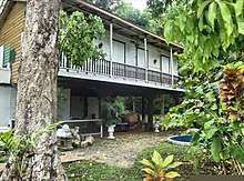
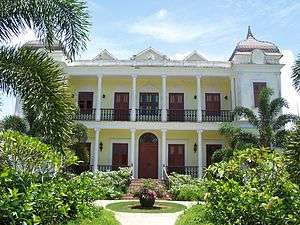
Landmarks and places of interest
- Enrique Laguerre House
- Enriqueta Hacienda
- Julia's Mundillo Shop
- Our Lady of Monserrate Parish
- Hacienda Labadie
- Palacete Los Moreau
Culture
Sports
Moca has a Double-A Baseball team called the Moca Vampiros that play in the Superior Baseball League.
- Juan Sanchez Acevedo Coliseum
Moca also had a volleyball team named "Los Rebeldes", which played in LVS (Liga de Voleibol Superior) through the years of 1998 to 2005. The team went to the post season every year, obtained a controversial second place in its 1998 final with the "Changos" of Naranjito. In addition, "Los Rebeldes" were National Champions against the "Changos" in the 2000 final. "Los Rebeldes" swept the "Changos" 4-0 in the finals.
Vampire Myth
Moca is famous in Puerto Rico for El Vampiro de Moca. El vampiro de Moca was believed to exist because cows were found dead after they had what appeared to be fang holes on their necks. Not only did cows appear with this phenomenon but also sheep and goats.
Government
Like all municipalities in Puerto Rico, Moca is administered by a mayor. The current mayor is José Avilés Santiago, from the New Progressive Party (PNP). Avilés was elected at the 2000 general election.
The city belongs to the Puerto Rico Senatorial district IV, which is represented by two Senators. In 2012, María Teresa González and Gilberto Rodríguez were elected as District Senators.[20]
Transportation
There are 12 bridges in Moca.[21] Moca used to have a taxi system or “Carros Públicos” but they were dismantled due to the popularity of the automobile.
Symbols
Flag
Erick De Jesus was the designer of the flag. The rectangular flag consists of a purple equilateral triangular field, the color of the Moca tree flower. In this field appear five-point stars, silver-plated, surrounding a greater gold star, also with five points.
Coat of arms
It has oblong form. Divided in a silver-plated field and blue sky united by a purple rhombus (diamond shape), the color of the Moca flower. The rhombus has within religious symbolisms. The rhombus is surrounded, in its inferior part, by two branches of the Moca tree; in its superior part, an arc of eleven silver-plated five-point stars. Within the rhombus is a gold monogram (of the Virgin Mary) topped by a Christian crown of the same metal. A silver-lined crown in form of a three-tower castle crowns the shield. On the frontal portion of the crown, carved in gold, the word Moca. The stones of the castle are lined in blue. The doors and windows are purple.
Gallery
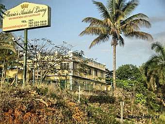 Hacienda Los Castillos Meléndez, Moca
 Monumento a la Tejedora letra en Moca
 Monument to women who work in lace, Moca is known for producing lace
 Old car in Moca barrio-pueblo
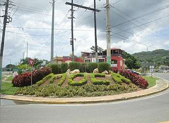 Moca, Puerto Rico welcome with landscape
See also
- List of Puerto Ricans
- History of Puerto Rico
- National Register of Historic Places listings in Moca, Puerto Rico
- Did you know-Puerto Rico?
References
- "Moca Municipality". enciclopediapr.org. Fundación Puertorriqueña de las Humanidades (FPH). Archived from the original on 2019-04-04. Retrieved 2019-03-20.
- "Preliminary Locations of Landslide Impacts from Hurricane Maria, Puerto Rico". USGS Landslide Hazards Program. USGS. Archived from the original on 2019-03-03. Retrieved 2019-03-03.
- "Preliminary Locations of Landslide Impacts from Hurricane Maria, Puerto Rico" (PDF). USGS Landslide Hazards Program. USGS. Archived (PDF) from the original on 2019-03-03. Retrieved 2019-03-03.
- "María, un nombre que no vamos a olvidar. [Maria, a name we'll never forget.]". El Nuevo Día (in Spanish).
- Picó, Rafael; Buitrago de Santiago, Zayda; Berrios, Hector H. Nueva geografía de Puerto Rico: física, económica, y social, por Rafael Picó. Con la colaboración de Zayda Buitrago de Santiago y Héctor H. Berrios. San Juan Editorial Universitaria, Universidad de Puerto Rico,1969. Archived from the original on 2018-12-26. Retrieved 2018-12-28.
- Gwillim Law (20 May 2015). Administrative Subdivisions of Countries: A Comprehensive World Reference, 1900 through 1998. McFarland. p. 300. ISBN 978-1-4766-0447-3. Retrieved 25 December 2018.
- Puerto Rico:2010:population and housing unit counts.pdf (PDF). U.S. Dept. of Commerce Economics and Statistics Administration U.S. Census Bureau. 2010. Archived (PDF) from the original on 2017-02-20. Retrieved 2018-12-26.
- "Map of Moca" (PDF). Archived (PDF) from the original on 2011-06-08. Retrieved 2007-12-19.
- "US Census Barrio-Pueblo definition". factfinder.com. US Census. Archived from the original on 13 May 2017. Retrieved 5 January 2019.
- "Agencia: Oficina del Coordinador General para el Financiamiento Socioeconómico y la Autogestión (Proposed 2016 Budget)". Puerto Rico Budgets (in Spanish). Retrieved 28 June 2019.
- Rivera Quintero, Marcia (2014), El vuelo de la esperanza: Proyecto de las Comunidades Especiales Puerto Rico, 1997-2004 (first ed.), San Juan, Puerto Rico Fundación Sila M. Calderón, ISBN 978-0-9820806-1-0
- "Leyes del 2001". Lex Juris Puerto Rico (in Spanish). Retrieved 24 June 2020.
- Rivera Quintero, Marcia (2014), El vuelo de la esperanza:Proyecto de las Comunidades Especiales Puerto Rico, 1997-2004 (Primera edición ed.), San Juan, Puerto Rico Fundación Sila M. Calderón, p. 273, ISBN 978-0-9820806-1-0
- "U.S. Decennial Census". United States Census Bureau. Archived from the original on February 13, 2020. Retrieved September 21, 2017.
- "Report of the Census of Porto Rico 1899". War Department Office Director Census of Porto Rico. Archived from the original on July 16, 2017. Retrieved September 21, 2017.
- "Table 3-Population of Municipalities: 1930 1920 and 1910" (PDF). United States Census Bureau. Archived (PDF) from the original on August 17, 2017. Retrieved September 21, 2017.
- "Table 4-Area and Population of Municipalities Urban and Rural: 1930 to 1950" (PDF). United States Census Bureau. Archived (PDF) from the original on August 30, 2015. Retrieved September 21, 2014.
- "Table 2 Population and Housing Units: 1960 to 2000" (PDF). United States Census Bureau. Archived (PDF) from the original on July 24, 2017. Retrieved September 21, 2017.
- "Census Demographics". Archived from the original on 2018-06-22. Retrieved 2018-06-22.
- Elecciones Generales 2012: Escrutinio General Archived 2013-01-15 at the Wayback Machine on CEEPUR
- "Moca Bridges". National Bridge Inventory Data. US Dept. of Transportation. Archived from the original on 20 February 2019. Retrieved 19 February 2019.