Vega Alta, Puerto Rico
Vega Alta (Spanish pronunciation: [ˈbeɣa ˈalta]) is a municipality of Puerto Rico. Vega Alta is located on the northern coast of the island, north of Morovis and Corozal; east of Vega Baja; and west of Dorado with an area of 28 square miles (73 km2). Vega Alta is subdivided into seven wards (called barrios) and Vega Alta Pueblo (the downtown area and the administrative center of the city). It is part of the San Juan-Caguas-Guaynabo Metropolitan Statistical Area.
Vega Alta Municipio Autónomo de Vega Alta | |
|---|---|
Town and Municipality | |
 | |
 Flag | |
| Nicknames: Pueblo de los Ñangotaos, Los Maceteros | |
| Anthem: "En La Costa Norte De Mi Islita" | |
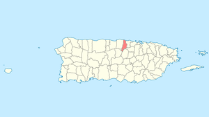 Location of Vega Alta in Puerto Rico | |
| Coordinates: 18°24′44″N 66°19′53″W | |
| Commonwealth | |
| Founded | 1775 |
| Government | |
| • Mayor | Oscar Santiago (PPD) |
| • Senatorial dist. | 3 - Arecibo |
| • Representative dist. | 11,12 |
| Area | |
| • Total | 27.75 sq mi (71.87 km2) |
| Population (2010) | |
| • Total | 39,951 |
| • Density | 1,400/sq mi (560/km2) |
| Demonym(s) | Vegalteños |
| Time zone | UTC-4 (AST) |
| Zip code | 00692 |
| Major routes | |
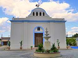
Vega Alta is west of San Juan, the capital of Puerto Rico. Vega Alta is known for the beach at Cerro Gordo. Other points of interest include the town's Catholic church, known as Inmaculada Concepción, founded in 1813, and the Vega Alta Forest.[1]
During the first week of December, Vega Alta celebrates its patron saint, The Immaculate Conception.
History

Vega Alta was founded in 1775 by Francisco de los Olivos. It was first named La Vega de Espinosa and known as el pueblo de los Ñangotaos (the town of the squatters", in reference to the jíbaros country folk who would wait for the train in a squatting position, due to lack of benches). Before this, it was part of a group of towns known as Las Vegas. It was then that one area was named Vega Baja and the other Vega Alta.
On October 12, 1898 the city's mayor, Francisco Vega, received U.S. troops as part of the Spanish–American War. On that same day, for the first time in Vega Alta's history, the U.S. flag was lifted on city hall. From 1902 to 1905, Vega Alta became once more part of the neighbor city of Vega Baja. In 1905, the government of Puerto Rico passed a law, allowing Vega Alta to become a municipality with its own limits.
Hacienda Carmen and Hacienda Ortega sugar plantations were owned by Juan Gualberto Landron y Martinez born in 1791 in Toa Baja . He owned slaves and purchased them, some coming directly from Africa.
The second-largest mosque, built in 1992, is located in Vega Alta.[2]
Geography
Vega Alta is on the northern coast.[3]
Río Cibuco, Río Mavilla and Río Unibón are located in Vega Alta. The Javier Calderón beach, better known as Cerro Gordo Beach is administered by the Puerto Rico Department of Sports and Recreation.[4]
Vega Alta has a land area of 27.75 square miles (71.87 km²) and water area of 9.76 square miles (25.28 km²).[5]
Hurricane Maria
Hurricane Maria on September 20, 2017 triggered numerous landslides in Vega Alta with the significant amount of rainfall.[6][7]
Barrios
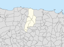
Like all municipalities of Puerto Rico, Vega Alta is subdivided into barrios. The municipal buildings, central square and large Catholic church are located in a barrio referred to as "el pueblo".[8][9][5][10]
Sectors
Barrios (which are like minor civil divisions)[11] in turn are further subdivided into smaller local populated place areas/units called sectores (sectors in English). The types of sectores may vary, from normally sector to urbanización to reparto to barriada to residencial, among others.[12][13][14]
Special Communities
Of the 742 places on the list of Comunidades Especiales de Puerto Rico, the following barrios, communities, sectors, or neighborhoods are in Vega Alta: Villa Alegria, Villa del Rio, Mavilla, Machuchal, El Nueve, Ponderosa, Manantial, and Corea.[15][16]
Climate
According to the Weather Channel's website, June is the warmest month, March is the coolest month, October is the wettest month, and June is the driest month. Records:
- The highest recorded temperature was 98 °F in July 2007.
- The lowest recorded temperature was 40 °F in January 1945.
Economy
In 1908, Vega Alta was producing coffee, sugar, oranges (which were famous in the United States) for their sweetness, tobacco and rum.[17]
Agriculture
- Banana, fruits, grains, and sugar cane.
- Flowers and ornamental plants.
- Dairy and meat cattle, pigs, and poultry.
Industry
- Manufacture of chemicals, electrical and electronic machinery, furniture, food, and plastics.
- Logistics Center
Culture
Sports
Vega Alta Maceteros[18] (Double A Baseball League)
Vega Alta is known for having amateur ball players as well as professional. Basketball is played in local communities. Other sports practiced include tennis, volleyball, handball, cock fighting, and amateur surfing among others.
Vega Alta is also known for having famous Major League Baseball players such as The Molina Brothers which consist of Yadier Molina, Bengie Molina and José Molina. Other famous sport personalities include former New York Yankees center fielder Bernie Williams and professional boxer Ángel Chacón.
Music
A well known musician from Vega Alta was Ladislao Martinez a.k.a. El Maestro Ladi (June 27, 1898–February 1, 1979), a master cuatro musician. He became the first Puerto Rican to play a cuatro solo on the radio.
Fiel a la Vega, a rock en español (rock in Spanish) band, was formed in 1994. Band members Tito Auger and Ricky Laureano are from Vega Alta, while brothers Pedro Arraiza and Jorge Arraiza come from next-door Vega Baja. Their first album spawned hits like Salimos de Aquí and El Wanabí, both of which were released with videos.
Tourism
Lin-Manuel Miranda tourism
The Puerto Rican, award-winning, musician and playwright Lin-Manuel Miranda who created the Broadway hit, "Hamilton", is from a family with roots in Vega Alta. In 2017, his dad opened La Placita Güisín, a cafe and restaurant in the downtown area of Vega Alta, and in 2019 Lin-Manuel moved his memorabilia to a new gallery, the Lin-Manuel Miranda Gallery, a few steps from Placita Güisín and opened a store there too, TeeRico. The location has become a tourist attraction.[19][20][21]
Festivals and events
There are 6 beaches in Vega Alta.[22] Some main attractions of Vega Alta include:
- Three Kings Fiestas - January
- Sung Rosary - February
- Vegalteño Carnival - February
- Kite Festival - July
- Virgen del Carmen Walk - July
- Rooster Festival - October
- Patron Festivities - December
Demographics
The United States took control of Puerto Rico from Spain in the aftermath of the Spanish-American War under the terms of the Treaty of Paris of 1898 and conducted its first census of Puerto Rico, finding that the population of Vega Alta was 6,107.
| Historical population | |||
|---|---|---|---|
| Census | Pop. | %± | |
| 1900 | 6,107 | — | |
| 1910 | 8,134 | 33.2% | |
| 1920 | 9,970 | 22.6% | |
| 1930 | 12,333 | 23.7% | |
| 1940 | 14,329 | 16.2% | |
| 1950 | 16,521 | 15.3% | |
| 1960 | 17,603 | 6.5% | |
| 1970 | 22,810 | 29.6% | |
| 1980 | 28,696 | 25.8% | |
| 1990 | 34,559 | 20.4% | |
| 2000 | 37,910 | 9.7% | |
| 2010 | 39,951 | 5.4% | |
| U.S. Decennial Census[23] 1899 (shown as 1900)[24] 1910-1930[25] 1930-1950[26] 1960-2000[27] 2010[5] | |||
- Population: 37,910 as of 2000 U.S. Census
- Density: 527.5 per km² (1,366.1 per sq mi)
- Housing units: 13,526
- Housing density: 188.2 per km²
- Per capita income: $7,356
Government

The main women's prison of the Puerto Rico Department of Corrections and Rehabilitation, Escuela Industrial para Mujeres in Vega Alta, opened in 1954, replacing a prison in Arecibo; work began on the facility in 1952. Puerto Rico also operates the Hogar de Adaptación Social en Vega Alta, which opened in 1987.[28]
Past and present mayors
- Antonio Navas
- Lorenzo Cabrera
- Emilio Escalera
- Arturo Rivera
- Ramon Cestero
- Emilio Davila Diaz
- Jose Vega Nevarez
- Francisco Chinea
- Carmelo Mercado
- Jacinto Seijo
- Jose Rosado Negron, (1977–1980; b. 1934, d. 1999)
- Manuel "Manolin" Chinea (PDP, 1981–1993)
- Isabelo "Chabelo" Molina (PNP, 1993–2001)
- Juan "Mane" Cruzado (PPD, 2001–2002) resigned, Vice-Mayor Jose Colon assumed post.
- Jose Colon (PPD, 2002–2005)
- Isabelo "Chabelo" Molina (PNP, 2005–2017)
- Oscar Santiago Martinez (PPD, 2017–present)
Transportation
Puerto Rico's Highway 22 provides access to Vega Alta from the far away city of Mayagüez, or from San Juan. Highway 2 also provides access from the western cities of Manatí, Arecibo and the eastern cities of Bayamón and Guaynabo bordering the shore to the Atlantic Ocean. It takes approximately 30 minutes to reach the town from San Juan. The closest airport is Luis Muñoz Marín International Airport in Carolina. Other public transportation close to the area is El Tren Urbano (TU).
There are 16 bridges in Vega Alta.[29]
Coat of arms
The shield is split up into 3 unequal bands in the following order:
- Silver/sometimes white blue Silver/sometimes white
- On both sides of the silver/white bands are branches
- In the center blue band is a vase containing flowers
- On top of the shield is a crown with 3 towers
Anthem
The anthem used by Vega Alta is the musical composition created in 1958, with lyrics by Domingo Figueroa Ramírez Arreglo and music by Domingo and Elliot A. Knight.
Education
Public schools
- Antonio Paoli/Elementary
- Elemental Urbana/Elementary
- Elisa Davila Vazquez/Elementary
- Ignacio Miranda/elementary school
- Dr. Cañaco Stalingrad III/ High School
- Jose D. Rosado/Elementary
- Jose M. Pagan/Elementary
- Rafael Hernadez/Elementary
- Apolo San Antonio/Former high school
- Nueva Escuela Brenas/Middle School, Second Unit
- Adelaida Vega/Middle School, Second Unit
- Ileana de Gracia/High School
- Ladislao Martinez (Maestro Ladi)/Second High School
Private schools
- Academia Dicipulos de Cristo (Disciples of Christ)/Elementary and Middle School
- Colegio de la Vega
- Academia Cambu
Notable natives and residents
- Yadier Molina - Professional baseball player
Further reading
- Leonardo Santana-Rabell. Historia de Vega Alta de Espinosa. 2da edición, Editorial La Torre del Viejo, Río Piedras, Puerto Rico, 1995.
- Domingo Figueroa Ramirez. Memorias y versos: Desde algun rincón de Vega Alta. 1era edición Vega Coop y Econo Mendez Class
See also
- List of Puerto Ricans
- History of Puerto Rico
- Did you know-Puerto Rico?
References
- "Municipalities: Vega Alta". Encyclopedia of Puerto Rico (in English and Spanish). San Juan: Fundación Puertorriqueña de las Humanidades. OCLC 234072526. Archived from the original on 2016-03-07. Retrieved May 16, 2017.
Mayors
- "Muslims in Puerto Rico". Arab News. December 28, 2012. Archived from the original on October 1, 2016. Retrieved July 25, 2019.
- "Vega Alta Municipality". enciclopediapr.org. Fundación Puertorriqueña de las Humanidades (FPH). Archived from the original on 2019-04-04. Retrieved 2019-03-20.
- "Balneario Cerro Gordo". drdpuertorico (in Spanish). Programa de Parques Nacionales de Puerto Rico. Archived from the original on 13 February 2019. Retrieved 13 February 2019.
- Puerto Rico:2010:population and housing unit counts.pdf (PDF). U.S. Dept. of Commerce Economics and Statistics Administration U.S. Census Bureau. 2010. Archived (PDF) from the original on 2017-02-20. Retrieved 2019-01-01.
- "Preliminary Locations of Landslide Impacts from Hurricane Maria, Puerto Rico". USGS Landslide Hazards Program. USGS. Archived from the original on 2019-03-03. Retrieved 2019-03-03.
- "Preliminary Locations of Landslide Impacts from Hurricane Maria, Puerto Rico" (PDF). USGS Landslide Hazards Program. USGS. Archived (PDF) from the original on 2019-03-03. Retrieved 2019-03-03.
- Picó, Rafael; Buitrago de Santiago, Zayda; Berrios, Hector H. Nueva geografía de Puerto Rico: física, económica, y social, por Rafael Picó. Con la colaboración de Zayda Buitrago de Santiago y Héctor H. Berrios. San Juan Editorial Universitaria, Universidad de Puerto Rico,1969. Archived from the original on 2018-12-26. Retrieved 2019-01-01.
- Gwillim Law (20 May 2015). Administrative Subdivisions of Countries: A Comprehensive World Reference, 1900 through 1998. McFarland. p. 300. ISBN 978-1-4766-0447-3. Retrieved 25 December 2018.
- "Map of Vega Alta at the Wayback Machine" (PDF). Archived from the original (PDF) on 2018-03-24. Retrieved 2018-12-29.
- "US Census Barrio-Pueblo definition". factfinder.com. US Census. Archived from the original on 13 May 2017. Retrieved 5 January 2019.
- "Agencia: Oficina del Coordinador General para el Financiamiento Socioeconómico y la Autogestión (Proposed 2016 Budget)". Puerto Rico Budgets (in Spanish). Retrieved 28 June 2019.
- Rivera Quintero, Marcia (2014), El vuelo de la esperanza: Proyecto de las Comunidades Especiales Puerto Rico, 1997-2004 (first ed.), San Juan, Puerto Rico Fundación Sila M. Calderón, ISBN 978-0-9820806-1-0
- "Leyes del 2001". Lex Juris Puerto Rico (in Spanish). Retrieved 24 June 2020.
- Rivera Quintero, Marcia (2014), El vuelo de la esperanza:Proyecto de las Comunidades Especiales Puerto Rico, 1997-2004 (Primera edición ed.), San Juan, Puerto Rico Fundación Sila M. Calderón, p. 273, ISBN 978-0-9820806-1-0
- "Comunidades Especiales de Puerto Rico" (in Spanish). 8 August 2011. Archived from the original on 24 June 2019. Retrieved 24 June 2019.
- Anuario del comercio, de la industria, de la magistratura y de la administración de España, sus colonias, Cuba, Puerto-Rico y Filipinas, estados hispano-americanos y Portugal (in Spanish). Bailly-Bailliere e Hijos. 1908. p. 353.
- "Archived copy". Archived from the original on 2018-08-05. Retrieved 2018-12-28.CS1 maint: archived copy as title (link)
- Paulson, Michael (December 26, 2018). "Lin-Manuel Miranda's Passion for Puerto Rico". NYT. Archived from the original on March 1, 2019. Retrieved February 28, 2019.
- Ayala Polley, Leonor (May 1, 2016). "In Lin-Manuel Miranda's Puerto Rican Town, Crisis Worries Family Members". NBC. Archived from the original on June 19, 2019. Retrieved February 28, 2019.
- "Lin-Manuel Miranda inaugura galería en Vega Alta". El Nuevo Dia. 30 April 2019. Archived from the original on 3 May 2019. Retrieved 3 May 2019.
- "Las 1,200 playas de Puerto Rico [The 1200 beaches of Puerto Rico]". Primera Hora (in Spanish). April 14, 2017. Archived from the original on December 12, 2019. Retrieved December 12, 2019.
- "U.S. Decennial Census". United States Census Bureau. Archived from the original on February 13, 2020. Retrieved September 21, 2017.
- "Report of the Census of Porto Rico 1899". War Department Office Director Census of Porto Rico. Archived from the original on July 16, 2017. Retrieved September 21, 2017.
- "Table 3-Population of Municipalities: 1930 1920 and 1910" (PDF). United States Census Bureau. Archived (PDF) from the original on August 17, 2017. Retrieved September 21, 2017.
- "Table 4-Area and Population of Municipalities Urban and Rural: 1930 to 1950" (PDF). United States Census Bureau. Archived (PDF) from the original on August 30, 2015. Retrieved September 21, 2014.
- "Table 2 Population and Housing Units: 1960 to 2000" (PDF). United States Census Bureau. Archived (PDF) from the original on July 24, 2017. Retrieved September 21, 2017.
- "Perfil de la Población de Mujeres Confinadas Año 2015" (Archive). Puerto Rico Department of Corrections and Rehabilitation. Retrieved on December 9, 2015.
- "Vega Alta Bridges". National Bridge Inventory Data. US Dept. of Transportation. Archived from the original on 20 February 2019. Retrieved 19 February 2019.