Aguada, Puerto Rico
Aguada (/əˈɡwɑːdə/; Spanish: [aˈɣwaða]) is a municipality of Puerto Rico, located in the western coastal valley region bordering the Atlantic Ocean, east of Rincón, west of Aguadilla and Moca; and north of Añasco and Mayagüez. It is part of the Aguadilla-Isabela-San Sebastián Metropolitan Statistical Area. Aguada's population is spread over 17 wards and Aguada Pueblo (the downtown area and the administrative center of the city).
Aguada Municipio de Aguada | |
|---|---|
City and Municipality | |
 The main plaza and the Roman Catholic Church of Aguada | |
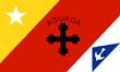 Flag 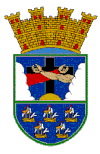 Coat of arms | |
| Nicknames: | |
| Anthem: "Muchos siglos han pasado" | |
 Location of Aguada in Puerto Rico | |
| Coordinates: 18°22′46″N 67°11′18″W | |
| Commonwealth | |
| Founded | 1508-1510[1]) |
| Founded by | Don Cristóbal de Sotomayor |
| Government | |
| • Mayor | Manuel "Gabina" Santiago Mendoza (Partido Nuevo Progresista) |
| • Senatorial dist. | 4 - Mayagüez |
| • Representative dist. | 18 |
| Area | |
| • Total | 45.55 sq mi (118.0 km2) |
| • Land | 30.93 sq mi (80.1 km2) |
| • Water | 14.62 sq mi (37.9 km2) 32[2]% |
| Population (2010[3]) | |
| • Total | 41,959 |
| • Density | 920/sq mi (360/km2) |
| Demonym(s) | Aguadeños |
| Time zone | UTC−4 (AST) |
| Zip code | 00602 |
| Major routes | |
| Website | aguada |
History
A Taíno settlement called Aymamón was located close to the Culebrinas River.[4][5]
Some sources believe that Christopher Columbus entered the island of Puerto Rico through Aguada on his second voyage in November 1493.[6][7]
In July 1510, Cristóbal de Sotomayor received control of the area from Juan Ponce de León and renamed the town Villa de Sotomayor. [8] However, in 1511 the settlement was attacked and burned by the local Taínos. That same year, the King ordered a monastery established in the island, and the Ermita de Espinar was founded. The name of the region was then changed to San Francisco de Asís de la Aguada, since the friars were Franciscan. The monastery was finished in 1516. In 1526, King Charles I of Spain officially founded the Aguada settlement. However, in 1529, Taínos attacked the monastery killing the friars and burning the settlement.[9]
Still, Aguada resurfaced and became a stopover point for ships on their way to Spain from South America.[10] On September 17, 1662, King Charles II of Spain emitted a Royal Decree declaring Aguada as a "village", and assigning Juan López de Segura as First Lieutenant.[9]
In 1737, Philip V, King of Spain, declared that all mail en route to Venezuela and other South American countries from Puerto Rico must exit from Aguada's ports, leading to the area's economic growth. Also, an increase in population has been attributed to possible desertions from foreign merchant ships.[11]
The United States acquired Puerto Rico from Spain in the aftermath of the Spanish-American War under the terms of the Treaty of Paris of 1898. In 1899, the US conducted its first census of Puerto Rico, finding that the population of Aguada was 10,581.
In the early years of the 20th Century, two disasters affected the town of Aguada. First, a huge fire in 1912 destroyed most of the town buildings, including the old city hall, which contained all the city archives. On October 11, 1918 at 10:14:42 local time an earthquake known as the San Fermín earthquake destroyed the church and other structures.[12] At Rio Culebrinas, 1000 kg blocks of limestone from the wrecked Columbus monument were carried inland to distances of 46–76 meters (151–249 feet) by waves 4.0 m (13.1 ft) high.[13]
Folklore
El Matador de Tiburones (the killer of sharks) is folklore that comes out of Aguada and was written around 1640. A young man who was accustomed to fighting sharks, was without his religious, good luck charms, when he was asked to demonstrate his shark-fighting capabilities to dignitaries who were visiting the island, from Spain. All day and night he pondered whether he would or would not fight a shark because he had never fought a shark without his religious lucky charm. The Spanish had increased their offer to 3 bars of Spanish gold. In the morning, as the shark came into the bay, the spectators who were gathered on the beach screamed and yelled in anticipation. Encouraged and unable to stop himself he jumped into the sea pursuing the shark and fought the shark with his bare hands, as he had done so many times before. Only this time he was nearly killed when the shark hit him with his tail. He received his prize of gold, he healed, but never again fought a shark in the open sea.[14]
Geography
Aguada is located in the west coast of the island of Puerto Rico. It borders the Atlantic Ocean and Aguadilla on the north, Moca on the east, Añasco on the south, and Rincón on the west. Aguada is part of the Coastal Plains of the West, which features alluvial and fertile terrain. Although the terrain is mostly plain, there are some mountains to the south and southeast.[15][16]
Among the mountains located in Aguada are the Atalaya peak, located within the limits of Aguada and Rincón. Also, the San Francisco mountain, which is the birthpoint of the Cordillera Central, and Cerro Gordo, peaking at 853 feet (260 meters).[17]
Water features
Aguada's hydrographic system is composed of the Río Culebrinas, Río Grande, Río Cañas, Río Culebra, Río Guayabo, and Río Ingenio. All of these rivers flow into the Mona Passage.[15] There are ten beaches in Aguada.[18]
Barrios
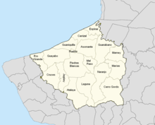
Like all municipalities of Puerto Rico, Aguada is subdivided into barrios:[19][20][21][22]
Sectors
Barrios (which are like minor civil divisions)[23] in turn are further subdivided into smaller local populated place areas/units called sectores (which means sectors in English). The types of sectores may vary, from normally sector to urbanización to reparto to barriada to residencial, among others.[24]
Special Communities
Of the 742 places on the list of Comunidades Especiales de Puerto Rico (Special Communities of Puerto Rico), the following barrios, communities, sectors, or neighborhoods are in Aguada: Parcelas Noboa Vieja and Parcelas Noboa Nuevas in Guanaquilla barrio, Calle San Francisco, Calle San José, Comunidad Las Flores, Sector Las Bimbas in Luyando comunidad, Parcelas Matías, Parcelas Nieves, and Sector García.[25]
Demographics
| Historical population | ||
|---|---|---|
| Year | Pop. | ±% |
| 1900 | 10,581 | — |
| 1910 | 11,587 | +9.5% |
| 1920 | 12,981 | +12.0% |
| 1930 | 14,670 | +13.0% |
| 1940 | 17,923 | +22.2% |
| 1950 | 20,743 | +15.7% |
| 1960 | 23,234 | +12.0% |
| 1970 | 25,658 | +10.4% |
| 1980 | 31,567 | +23.0% |
| 1990 | 35,911 | +13.8% |
| 2000 | 42,042 | +17.1% |
| 2010 | 41,959 | −0.2% |
| U.S. Decennial Census[26] 1899 (shown as 1900)[27] 1910-1930[28] 1930-1950[29] 1960-2000[30] 2010[21] | ||
| Racial - (self-defined) Aguada, Puerto Rico - 2010 Census[31] | ||
|---|---|---|
| Race | Population | % of Total |
| White | 36,350 | 86.6% |
| Black/Afro Puerto Rican | 2,226 | 5.3% |
| Native Americans and Alaska Native | 129 | 0.3% |
| Asian | 22 | 0.1% |
| Native Hawaiian Pacific Islander | 0 | 0.0% |
| Some other race | 2,222 | 5.3% |
| Two or more races | 1,010 | 2.4% |
In 2010, the population of Aguada was 41,959, which represented a small decrease from the 42,042 registered in the 2000 Census.[32] This has been the first decrease in population in the last century, since Aguada's population had been increasing steadily from 14,670 in 1930 to its current population.[33]
According to the 2010 Census, 86.6% of the population identifies themselves as White, and 5.3% as Black. Also, according to the census, the population is equally divided by gender (49.1% are males, while 50.1% are females). Finally, 23.7% of the population is under 18 years old. The next biggest percentage of population (20.8%) is between 35 and 49 years old.[34]
Religion
The Caribs, indigenous people of Puerto Rico, were believed to have practiced polytheism. As the Spanish began to colonise the Caribbean area, they wanted to convert the natives to Catholicism.[35] The Caribs destroyed a church of Franciscans in Aguada, and killed five of its members, in 1579.[36]
Economy

Historically, the economy of Aguada was mostly based on the processing of sugarcane. The Central Coloso, located in the Guanábano ward of Aguada, was one of the most important refineries in the island. It was also the last one to cease operations, officially closing in 2003.[16][37]
Aside from sugar mills, there was also a cattle and wood industry. As of 2012, the economy relies mostly on small businesses and manufacturing.[15]
In late 2014, the government announced a $172 million deal with private investors to restart sugar production in Puerto Rico for the purpose of supplying the island rum producers with up to 56% of the molasses needed. The plan involved building a new processing plant on the grounds of the old Coloso Sugar Cane factory in Aguada.[38]
Tourism
Aguada is part of the Porta del Sol touristic region in Puerto Rico. The Porta del Sol website highlights Aguada's town square and beaches as its most notable touristic attractions. It also mentions landmarks like the Espinar Hermitage Ruins[39] and a children playground.[40]
Landmarks and places of interest
- Aguada Museum located in a former railroad station building.
- Coloso Sugar Cane Refinery
- La Cruz de Culebrinas
- Pico de Piedra Beach
- Playa Espinar
- Loma Linda Stables
- San Francisco de Asís Parish
- Aguada transmission station, the tallest man-made structure in Puerto Rico
Human resources
Education
Like all other municipalities in the island, public education is overseen by the Puerto Rico Department of Education. In 2020, there were 11 public schools in Aguada, most of them in the elementary level.[41][42]
| # | School Name | ± Students as of 2018-2019 | Grades |
| 1. | Anselmo Villarubia | 303 | PK-5 |
| 2. | Aquilino Caban | 501 | PK-8 |
| 3. | Centro Vocacional Especial | 126 | Vocational |
| 4. | Dr. Carlos Gonzalez | 832 | 10-12 |
| 5. | Eladio Tirado Lopez | 279 | 9-12 |
| 6. | Jose Gonzalez Ruiz | 146 | KG-5 |
| 7. | Juan L. Santiago | 601 | PK-6 |
| 8. | Lydia Melendez | 253 | KG-5 |
| 9. | Profesora Juana Rosario | 491 | 6-9 |
| 10. | Su Epifanio Estrada | 664 | PK-8 |
| 11. | Su Juan B. Soto | 293 | PK-8 |
Public health
Although there are no hospitals in Aguada, the town does have a small emergency medical center located near the town center.
Culture
Festivals
Celebrations in Aguada include:[4]
Festival de Reyes (Three Kings Festival) which is celebrated in January at Paraíso de los Niños park. It is an activity dedicated to children of Aguada and is celebrated with gifts, music, clowns, and raffles.[4]
Festival de Playa (Beach Festival) is celebrated on June 24, the day of San Juan Bautista (Saint John the Baptist), at the Pico de Piedra Beach.
Aguada celebrates its fiestas patronales dedicated to Saint Francis of Assisi. The Patron Saint Festival in honor of Saint Francis of Assisi is held from September 24 to October 4 at the Plaza Carlos Ruiz. Some of the activities surrounding this festival include the praying of the rosary, a procession, arts and crafts, rides, and competitions in the area for parties.[43]
Festival y Feria de Artesanías (Craft Fair) takes place from November 17-20 at the Plaza Cristóbal Colón.[4]
Every year in November, a parade called La Parada del Descubrimento takes place to remember the discovery of Puerto Rico by Christopher Columbus. In this parade the people walk from the Catholic church in the town square to the Santurario Histórico a Colón (Cross of Columbus) next to the beach in Guaniquilla.[44]
Festival de Cabras de Raza is held on the last weekend of May in the Atalaya barrio, with exhibitions of different goat breeds and competitions.[4]
Parranda del Octavón is a one-day annual, cultural activity that takes place in January at the Plaza Cristóbal Colón, with local music.[4]
Encuentro de Talladores (Carvers' Meeting) is a one-day annual celebration that takes place the first weekend of July at the Plaza Cristóbal Colón, to commemorate the birthday of Don Zoilo Cajigas a carver of wooden saints. Carved wooden saints are on exhibition and for sale.[4]
Sports
Los Santeros de Aguada is the name of Aguada's basketball team.[45]
Transportation
The main road leading to Aguada is PR-115, if you're coming from the north. If you're traveling from the south, you have to take PR-2.
There are 18 bridges in Aguada.[46]
Government
Mayors
All municipalities in Puerto Rico are administered by a mayor, elected every four years. The current mayor of Aguada is Manuel "Gabina" Santiago Mendoza, of the (PNP). He was elected at the 2016 general elections.
This is a list of registered and known mayors of Aguada, until present time.[47]
| Years | Mayor | Political Party |
|---|---|---|
| 1921 - 1928 | Manuel Ruiz Gonzalez | |
| 1928 - 1932 | Carlos Gonzalez | |
| 1932 - 1936 | Efigenio Charneco | |
| 1936 - 1940 | Femando Rivera | |
| 1940 - 1944 | Andres Carrero | |
| 1944 - 1948 | Juan Villarrubia Santiago | PPD |
| 1948 - 1960 | Manuel Egipciaco | PPD |
| 1960 - 1968 | Juan Figueroa Gonzalez | PPD |
| 1968 - 1972 | Julio C. Roman Gonzalez (Yuyo) | PNP |
| 1972 - 1976 | Mabel Velez de Acevedo | PPD |
| 1976 - 2000 | Julio C. Roman Gonzalez (Yuyo) | PNP |
| 2000 - 2004 | Miguel A. Ruiz Hernandez (Miguelito) | PPD |
| 2004 - 2012 | Luis A. Echevarria Santiago (Berty) | PNP |
| 2012–2016 | Jessie Cortés Ramos | PPD |
| 2017–present | Manuel "Gabina" Santiago Mendoza | PNP |
Senate
The city belongs to the Puerto Rico Senatorial district IV of Mayagüez-Aguadilla, which is represented by two Senators. In 2016, Evelyn Vázquez and Luis Daniel Muñiz were elected as District Senators.[48]
Symbols
Flag
Aguada's flag was designed by Pedro Vélez Adróvar. It features three main colors: white, red, and yellow. White represents purity and the waters of Culebrinas River. Over the white field, a blue triangle with a blue dove is featured. The dove is the symbol of peace that unites the towns. Red symbolizes the martyrdom of Franciscan friars from Espinal. Over the red field, there's a cross which represents the birth of Christianity in Puerto Rico. The name of "Aguada" is also above the cross. The yellow field represents happiness and hospitality of the residents. Over the yellow field, there's a star which symbolizes the hope of the town for more development and progress.[49]
Coat of Arms
The coat of arms is divided into two main fields. The upper field features a cross, with the interlaced arms of Christ and Father Saint Francis. It is taken from the badge of the Order of Friars Minor. It represents the motto "Pax et Bonum", which means "peace and good will between man and the Redeemer". The sun below the cross symbolizes the light that brightens the world. The lower part of the shield consists of five ships that symbolize the second voyage of Christopher Columbus, who allegedly arrived at the western "Guaniquilla" coast on November 19, 1493 to gather water. Although the precise location is disputed, the Aguada wells is a plausible site for the actual event.
The mural crown in the upper part of the shield signifies the title of village, that was given to this town by King Charles III in 1778. The official colors of the shield are: red, which stands for the fraternal love in Aguada; gold, for the Spanish royalty in Puerto Rico; green, for the island's hope and fertility; black, for the wooden beam of the cross; blue, for the sky and the kingship of God; and white, for Christ's purity and the purity of the people of the town toward the cultural patrimony.[50][51]
Nicknames
Aguada has various nicknames, most of them pertaining to its origins. One is "La Villa del Sotomayor" ("Sotomayor Village"), which was the name originally given to it by Cristóbal de Sotomayor during its colonization in 1510. It is also called "Villa de San Francisco de Asís de la Aguada", which was the name given to the region when the Franciscan friars took control of it. Aguada is also called "La Ciudad del Descubrimiento" ("City of the Discovery") in reference to it being one of the possible places where Christopher Columbus entered the island. Other nicknames are "El Pueblo Playero" ("The Beach Town") for its many beaches, and "La Ciudad del Vaticano" ("The Vatican City") for being considered the "capital of Catholicism" in the island.[52][53]
Notable "Aguadeños"
- Ismael Miranda - Salsa Singer
- Guillermo "Willie" Hernandez - former Major League Baseball(MLB) pitcher and winner of the 1984 American League MVP and Cy Young Awards.
- Andrés Torres - Major League Baseball Player (San Francisco Giants World Champions)
- Zoilo Cajigas Sotomayor - Wood carving artist, especially religious figurines[55]
- Carlos Gonzalez, MD.
See also
- List of Puerto Ricans
- History of Puerto Rico
- National Register of Historic Places listings in Aguada, Puerto Rico
References
- Aguada: Founding and History. Archived 2019-02-14 at the Wayback Machine Accessed 10 September 2019.
- "EPA Municipio Aguada Discharges" (PDF). Archived (PDF) from the original on 2018-08-05. Retrieved 2018-08-05.
- "Census Tract". Retrieved 2011-04-10.
- "AGUADA - ¡LA VILLA DE SOTOMAYOR!" (PDF). aguada.gov.pr (in Spanish). PR Government. Archived (PDF) from the original on 21 September 2018. Retrieved 16 June 2020.
- Caciques y Yucayeques de Puerto Rico Archived November 7, 2012, at the Wayback Machine on Proyecto Salon Hogar
- "Cristóbal Colón". Archived from the original on 2014-07-01. Retrieved 2012-05-20.
- Aguada también quiere la estatua de Cristóbal Colón Archived 2010-11-24 at the Wayback Machine on Primera Hora; Vargas, Maelo (July 26, 2010)
- Fuson, Robert (2000). Juan Ponce De Leon and the Spanish Discovery of Puerto Rico and Florida. Blacksburg, Virginia: McDonald & Woodward. p. 79. ISBN 0-939923-82-3.
- Aguada, la Villa del Sotomayor Archived 2014-07-17 at the Wayback Machine on Proyecto Salon Hogar
- Mari Mut, José A. (28 August 2013). "Los pueblos de Puerto Rico y las iglesias de sus plazas" (in Spanish). Retrieved 23 June 2020 – via archive.org.
- "Aguada Municipality". Enciclopedia PR. Archived from the original on 14 February 2019. Retrieved 14 February 2019.
- Aguada: Fundación e historia Archived 2014-07-01 at the Wayback Machine on Enciclopedia de Puerto Rico
- Tsunamis in the Caribbean Sea - NOAA
- "Selección de Leyendas puertorriqueñas - El Matador de Tiburones (1640)". ufdc (in Spanish). p. 27. Archived from the original on 2019-03-06. Retrieved 2019-03-04.
- Aguada Archived 2012-06-17 at the Wayback Machine on Enciclopedia de Puerto Rico
- "Aguada Municipality General Info (Location, Square Miles, Economy and Geography)". enciclopediapr. Fundación Puertorriqueña de las Humanidades (FPH). Archived from the original on 14 February 2019. Retrieved 14 February 2019.
- Aguada Archived 2011-10-08 at the Wayback Machine on SalonHogar.com
- "Las 1,200 playas de Puerto Rico [The 1200 beaches of Puerto Rico]". Primera Hora (in Spanish). April 14, 2017. Archived from the original on December 12, 2019. Retrieved December 12, 2019.
- Picó, Rafael; Buitrago de Santiago, Zayda; Berrios, Hector H. Nueva geografía de Puerto Rico: física, económica, y social, por Rafael Picó. Con la colaboración de Zayda Buitrago de Santiago y Héctor H. Berrios. San Juan Editorial Universitaria, Universidad de Puerto Rico,1969. Archived from the original on 2018-12-26. Retrieved 2019-01-13.
- Gwillim Law (20 May 2015). Administrative Subdivisions of Countries: A Comprehensive World Reference, 1900 through 1998. McFarland. p. 300. ISBN 978-1-4766-0447-3. Retrieved 25 December 2018.
- Puerto Rico:2010:population and housing unit counts.pdf (PDF). U.S. Dept. of Commerce, Economics and Statistics Administration, U.S. Census Bureau. 2010. Archived (PDF) from the original on 2017-02-20. Retrieved 2019-01-13.
- "Map of Aguada" (PDF). Archived from the original (PDF) on 2015-04-17. Retrieved 2018-12-29.
- "US Census Barrio-Pueblo definition". factfinder.com. US Census. Archived from the original on 13 May 2017. Retrieved 5 January 2019.
- "DESGLOSE DE SECTORES Y CENTROS DE VOTACIÓN PRECINTO ELECTORAL - AGUADA 038" (PDF). Comisión Estatal de Elecciones Puerto Rico (in Spanish). 28 October 2019. Archived (PDF) from the original on 16 June 2020. Retrieved 16 June 2020.
- Rivera Quintero, Marcia (2014), El vuelo de la esperanza:Proyecto de las Comunidades Especiales Puerto Rico, 1997-2004 (Primera edición ed.), San Juan, Puerto Rico Fundación Sila M. Calderón, p. 273, ISBN 978-0-9820806-1-0
- "U.S. Decennial Census". United States Census Bureau. Archived from the original on February 13, 2020. Retrieved September 21, 2017.
- "Report of the Census of Porto Rico 1899". War Department, Office Director Census of Porto Rico. Archived from the original on July 16, 2017. Retrieved September 21, 2017.
- "Table 3-Population of Municipalities: 1930, 1920, and 1910" (PDF). United States Census Bureau. Archived (PDF) from the original on August 17, 2017. Retrieved September 21, 2017.
- "Table 4-Area and Population of Municipalities, Urban and Rural: 1930 to 1950" (PDF). United States Census Bureau. Archived (PDF) from the original on August 30, 2015. Retrieved September 21, 2014.
- "Table 2 Population and Housing Units: 1960 to 2000" (PDF). United States Census Bureau. Archived (PDF) from the original on July 24, 2017. Retrieved September 21, 2017.
- Bureau, U. S. Census. "American FactFinder - Results". factfinder. Archived from the original on 2015-11-20. Retrieved 2019-03-04.
- Censo 2000: Población de Puerto Rico por Municipios y Barrios Archived 2014-07-02 at the Wayback Machine on CEEPUR
- "Población de Puerto Rico por Municipios: 1930-2000". CEEPUR. Archived from the original on 2013-03-21.
- "2010 Census Interactive Population Search: Aguada, Puerto Rico". US Census 2010. Archived from the original on 2013-07-27.
- Menhinick, Kevin, "The Caribs in Dominica" Archived 2012-03-03 at the Wayback Machine
- Puerto Rico. Office of Historian (1949). Tesauro de datos historicos: indice compendioso de la literatura histórica de Puerto Rico, incluyendo algunos datos inéditos, periodísticos y cartográficos (in Spanish). Impr. del Gobierno de Puerto Rico. p. 238. Retrieved 4 January 2020.
- Central Coloso Archived 2012-07-08 at the Wayback Machine on Enciclopedia de Puerto Rico
- Archived 2015-01-01 at the Wayback Machine on El Nuevo Día newspaper
- Ruinas de la Ermita Espinar Archived 2012-10-06 at the Wayback Machine on Travel and Sports
- Porta del Sol - Pueblos Archived June 5, 2012, at the Wayback Machine on Porta del Sol
- "Directorio Comprensivo de Escuelas Públicas, Puerto Rico 2018 | Puerto Rico Government Open Data Portal". data.pr.gov. Archived from the original on 2018-10-04. Retrieved 2020-03-28.
- "Search for Public Schools". nces.ed.gov. Archived from the original on 2020-04-17. Retrieved 2020-03-29.
- "LinkToPuertoRico.com - Aguada" (in Spanish). Proyecto Salon Hogar. Archived from the original on 2014-07-17. Retrieved 2017-12-27.
- "Aguada celebra sus 500 años". El Nuevo Día (in Spanish). November 21, 2010. Archived from the original on January 22, 2013.
- VOCERO, Redacción, EL. "Bayamón y Aguada comandan en el inicio de los cuartos de final". El Vocero de Puerto Rico.
- "Aguada Bridges". National Bridge Inventory Data. US Dept. of Transportation. Archived from the original on 20 February 2019. Retrieved 19 February 2019.
- Aguada... la Villa de Sotomayor Archived 2014-07-17 at the Wayback Machine on ProyectoSalonHogar
- Elecciones Generales 2012: Escrutinio General Archived 2013-01-15 at the Wayback Machine on CEEPUR
- Bandera de Aguada Archived 2012-01-06 at the Wayback Machine on Aguada Official website
- "Banderas y escudos municipales" (Flags and Municipal Shields) by Anisa Productions Inc.
- Escudo de Aguada Archived 2015-10-04 at the Wayback Machine on Aguada Official website
- Aguada Archived April 16, 2009, at the Wayback Machine on FiliRealty
- "Directorio de Municipios de Puerto Rico". pr.gov. Archived from the original on 2019-03-15. Retrieved 2019-03-15.
- Aguada Archived 2011-10-08 at the Wayback Machine on Salon Hogar
- "Museo de Tallas de Santos" (in Spanish). Archived from the original on 2018-08-05. Retrieved 2018-08-05.
External links
- Puerto Rico Government Directory - Aguada
- Aguada Municipality Brochure (Spanish)
- Proyecto Salón Hogar sobre Aguada (Spanish)
- Photos of Aguada
- Aguada Municipality on Facebook