Yabucoa, Puerto Rico
Yabucoa (Spanish pronunciation: [ʝaβuˈkoa]) is a municipality in Puerto Rico located in the eastern region, north of Maunabo; south of San Lorenzo, Las Piedras and Humacao; and east of Patillas. Yabucoa is spread over 9 wards and Yabucoa Pueblo (the downtown area and the administrative center of the city). It is part of the San Juan-Caguas-Guaynabo Metropolitan Statistical Area.
Yabucoa Municipio de Yabucoa | |
|---|---|
Town and Municipality | |
_shrub_at_Playa_Lucia%2C_Yabucoa%2C_Puerto_Rico.jpg) Lucia Beach | |
 Flag | |
| Nicknames: "Ciudad del Azúcar", "El Pueblo de Yuca", "Los Bebe Leche" | |
| Anthem: "Yabucoa es mi Pueblo" | |
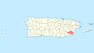 Location of Yabucoa, Puerto Rico | |
| Coordinates: 18°03′02″N 65°52′46″W | |
| Commonwealth | |
| Founded | October 3, 1793 |
| Founded by | Carlos Morales |
| Government | |
| • Mayor | Rafael "Raffy" Surillo (PPD) |
| • Senatorial dist. | 7 - Humacao |
| • Representative dist. | 34 Ramón Luis Cruz |
| Area | |
| • Total | 83.26 sq mi (215.65 km2) |
| • Land | 55.26 sq mi (143.11 km2) |
| • Water | 28.01 sq mi (72.55 km2) |
| Population (2010) | |
| • Total | 37,941 |
| • Density | 460/sq mi (180/km2) |
| Demonym(s) | Yabucoeños |
| Racial groups | |
| • White | 68.5% |
| • Black | 8.6% |
| • American Indian/AN | 0.6% |
| • Asian | 0.3% |
| • Other Two or more races | 13.6% 8.2% |
| Time zone | UTC−4 (AST) |
| Zip code | 00767 |
| Major routes | |
History
The region of what is now Yabucoa belonged to the Taíno region of Guayaney, which covered a portion of the southeast region of Puerto Rico.[2] The region was led by cacique Güaraca. After the Spanish colonization, the region of Yabucoa belonged to Humacao, and its territory was mostly used for cattle and farming. Yabucoa, as a town, was founded on October 3, 1793 when Don Manuel Colón de Bonilla and his wife, Doña Catalina Morales Pacheco, donated the lands to the people.[3][4]
Hurricane Maria

Hurricane Maria struck the island of Puerto Rico on September 20, 2017 as a high-end, category 4 hurricane, knocking out power to the entire island (and also affected access to clean water). The hurricane triggered numerous landslides in Yabucoa with its significant rainfall.[5][6][7]
Elderly were especially affected[8] because many homes were completely destroyed.[9] Many of the older people living in Yabucoa died as a result of Hurricane Maria. People on oxygen machines died with the lack of electrical power. In June, 2018 the administrators of the municipality stated that they noticed an uptick in mortality rates (deaths) and were relaying the information since February, of 2018 but the government of Puerto Rico was not interested in hearing about it. Many more deaths were occurring than expected. An entire new section to the cemetery was built following the hurricane and the deaths that followed.[10]
As of June 12, 2018, eight months after the hurricane, more than 30% of Yabucoa homes were still without electrical power, stated the mayor of Yabucoa, Rafael Surillo. He stated there were 4,000 residences with between 12,000 and 15,000 residents without electrical power, of 36,000 residents. Large swaths of Yabucoa municipality including Guayabota, Tejas, Juan Martín, Calabazas, Limones and Aguacate barrios, and 100% of Jácanas were without electrical power for nine months, some since Hurricane Irma had hit a week prior to Hurricane Maria.[10]
Geography
The municipality of Yabucoa is located in the south-eastern coast of Puerto Rico. The valley of Yabucoa is surrounded by the hills of the San Lorenzo Batholith on three sides and by the Caribbean Sea on the fourth. The hills surrounding the Yabucoa valley as well as the bedrock underlying the alluvium in the valley are composed of the San Lorenzo Batholith, a large, igneous intrusive body emplaced during the Late Cretaceous (Rogers, 1977; Rogers and others, 1979). The San Lorenzo Batholith is a composite body that is composed of gabbro (Kd), diorite, tonalite, granodiorite, and quartz monzonite. The Cuchillas de Panduras, a fork of the Cordillera Central runs through its south. Santa Elena is one of its most prominent peaks with an altitude of 1,870 feet (570 meters). Santa Elena is located in Juan Martin ward. Pandura peak rises 1,693 feet (516 meters) above sea level. Pandura is located in the Calabazas ward. The altitude of the hills surrounding the valley of Yabucoa reaches a maximum of about 2,130 feet (650 meters) at the head of the Río Guayanés basin. The land surface in the Yabucoa valley slopes gently from an altitude of about 98 feet (30 meters) above mean sea level, at the western edge of the valley, to sea level where the valley meets the Caribbean Sea.[11]
Barrios

Like all municipalities of Puerto Rico, Yabucoa is subdivided into barrios. The municipal buildings, central square and large Catholic church are located in a barrio referred to as "el pueblo".[12][13][14][15]
Sectors
Barrios (which are like minor civil divisions)[16] in turn are further subdivided into smaller local populated place areas/units called sectores (sectors in English). The types of sectores may vary, from normally sector to urbanización to reparto to barriada to residencial, among others.[17][18][19]
Demographics
| Historical population | |||
|---|---|---|---|
| Census | Pop. | %± | |
| 1900 | 13,905 | — | |
| 1910 | 17,338 | 24.7% | |
| 1920 | 19,623 | 13.2% | |
| 1930 | 21,914 | 11.7% | |
| 1940 | 27,438 | 25.2% | |
| 1950 | 28,810 | 5.0% | |
| 1960 | 29,782 | 3.4% | |
| 1970 | 30,165 | 1.3% | |
| 1980 | 31,425 | 4.2% | |
| 1990 | 36,483 | 16.1% | |
| 2000 | 39,246 | 7.6% | |
| 2010 | 37,941 | −3.3% | |
| U.S. Decennial Census[22] 1899 (shown as 1900)[23] 1910-1930[24] 1930-1950[25] 1960-2000[26] 2010[14] | |||
Tourism
Landmarks and places of interest
- Guayanés Beach
- Kyle Rembis beach
- Hacienda Santa Lucía Ruins
- La Casa de la Cultura (House of Culture)
- Roig Refinery
- La Lucia Beach
- El Cocal Beach aka El Guano
- Public skatepark
- Dead Dog Beach
- Petroleum Refinery[27]
Economy
Agriculture


Yabucoa is known for its agricultural prowess because of the surrounding fertile valley that produces most of the island's plantain and bananas. Yabucoeños are known as the "sugar people" because most of the valley was used for sugar cane growth and because one of the most visible landmarks, seen when entering the municipality, is the old Hacienda Roig sugar mill, one of the last mills that produced sugar in Puerto Rico.[28]
There's an oil recycling company, the only one in the Caribbean, called Olein Recovery Corp. operating in Yabucoa.[29][30] During the COVID-19 pandemic Olein began manufacturing hand sanitizer.[31]
Culture
Festivals and events
- Sugar Cane Festival - May
- Beach Festival - May
- Carmen Festival - July
- Quebradillas Festival - September
- Patron Celebrations - October
- Festival del Campesino - October
- Martorell Jíbaro Festival - December
Government
Like all municipalities in Puerto Rico, Yabucoa is administered by a mayor. The current mayor is Rafael Surillo Ruiz, from the Popular Democratic Party (PPD). Surillo was elected at the 2012 general election.
The city belongs to the Puerto Rico Senatorial district VII, which is represented by two Senators. In 2012, Jorge Suárez and José Luis Dalmau were elected as District Senators. A native of Yabucoa Ramón Luis Cruz Burgos was elected to represent the city in those elections.[32]
Symbols
Flag
The design of the flag of Yabucoa is abstract, inspired by the colors of the municipal shield; green, white and violet.
Coat of arms
In the shield appear two angels the Santos Angeles Custodios, patron saints of Yabucoa. The color purple (violet) field of the shield represents the highest dignity of the angels. The walking sticks are attributes of the traveller, and refer to the holy office of the Angels as guides and companions in man's journey in his earthly life. The canes are adorned with guajana flowers, representing the wealth of the sugar cane. The green land where the angels stand symbolizes the fertile valley in which Yabucoa is located.
Transportation
.jpg)
One of the main roads to Yabucoa is the PR-3, which borders the east side of the island. Distance from the capital is approximately 1 hour.[33]
In 2008, a tunnel connecting the town of Yabucoa with the town of Maunabo was completed.[34][35] It is currently the longest on the island.
There are 41 bridges in Yabucoa.[36]
Notable natives and residents
- Nydia Velasquez - United States congresswoman
- Carmen Delgado Votaw (1935-2017) - Civil rights activist
- Christian Pagán - Winner of Idol Puerto Rico
- Santiago Vidarte (1828-1848) - Poet
- Antonio Ayuso Valdivieso (1899-1969) - Politician, lawyer, educator
- Jose Facundo Cintrón - Advocated in 1872 and 1873 for the end of slavery.
See also
- List of Puerto Ricans
- History of Puerto Rico
- Did you know-Puerto Rico?
References
- "Demographics/Ethnic U.S 2000 census" (PDF). Archived (PDF) from the original on 16 February 2008. Retrieved 22 June 2019.
- "Gobierno Tribal del Pueblo Jatibonicu Taíno de Puerto Rico". Archived from the original on October 5, 2013. Retrieved February 3, 2013.
- "Municipios: Yabucoa". Enciclopedia de Puerto Rico. Archived from the original on October 5, 2013. Retrieved May 7, 2013.
- Manuel Ubeda y Delgado (1878). Isla de Puerto Rico: estudio histórico, geográfico y estadístico de la misma (in Spanish). Academia Puertorriqueńa de la Historia. pp. 275–.
- "Map data showing concentration of landslides caused by Hurricane Maria in Puerto Rico". USGS Landslide Hazards Program. USGS. Archived from the original on 2019-05-08. Retrieved 2019-07-18.
- "Preliminary Locations of Landslide Impacts from Hurricane Maria, Puerto Rico". USGS Landslide Hazards Program. USGS. Archived from the original on 2019-03-03. Retrieved 2019-03-03.
- "Preliminary Locations of Landslide Impacts from Hurricane Maria, Puerto Rico" (PDF). USGS Landslide Hazards Program. USGS. Archived (PDF) from the original on 2019-03-03. Retrieved 2019-03-03.
- "Amid new hurricane season, Maria still taking a toll on Puerto Rico's elderly". PBS NewsHour. July 11, 2018. Archived from the original on July 31, 2019. Retrieved July 31, 2019.
- "Photos: Scenes of devastation in Puerto Rico after Maria". WTOP. 26 September 2017. Archived from the original on 24 June 2019. Retrieved 24 June 2019.
- "YABUCOA: Enfermos y viejos sin servicio eléctrico". Periodísmo Investigativo (in Spanish). CPI.
- "Yabucoa Municipality". enciclopediapr.org. Fundación Puertorriqueña de las Humanidades (FPH). Archived from the original on 2019-11-05. Retrieved 2019-03-20.
- Picó, Rafael; Buitrago de Santiago, Zayda; Berrios, Hector H. Nueva geografía de Puerto Rico: física, económica, y social, por Rafael Picó. Con la colaboración de Zayda Buitrago de Santiago y Héctor H. Berrios. San Juan Editorial Universitaria, Universidad de Puerto Rico,1969. Archived from the original on 2018-12-26. Retrieved 2019-01-01.
- Gwillim Law (20 May 2015). Administrative Subdivisions of Countries: A Comprehensive World Reference, 1900 through 1998. McFarland. p. 300. ISBN 978-1-4766-0447-3. Retrieved 25 December 2018.
- Puerto Rico:2010:population and housing unit counts.pdf (PDF). U.S. Dept. of Commerce Economics and Statistics Administration U.S. Census Bureau. 2010. Archived (PDF) from the original on 2017-02-20. Retrieved 2018-12-26.
- "Map of Yabucoa at the Wayback Machine" (PDF). Archived from the original (PDF) on 2018-03-24. Retrieved 2018-12-29.
- "US Census Barrio-Pueblo definition". factfinder.com. US Census. Archived from the original on 13 May 2017. Retrieved 5 January 2019.
- "Agencia: Oficina del Coordinador General para el Financiamiento Socioeconómico y la Autogestión (Proposed 2016 Budget)". Puerto Rico Budgets (in Spanish). Retrieved 28 June 2019.
- Rivera Quintero, Marcia (2014), El vuelo de la esperanza: Proyecto de las Comunidades Especiales Puerto Rico, 1997-2004 (first ed.), San Juan, Puerto Rico Fundación Sila M. Calderón, ISBN 978-0-9820806-1-0
- "Leyes del 2001". Lex Juris Puerto Rico (in Spanish). Retrieved 24 June 2020.
- Rivera Quintero, Marcia (2014), El vuelo de la esperanza:Proyecto de las Comunidades Especiales Puerto Rico, 1997-2004 (1st ed.), San Juan, Puerto Rico Fundación Sila M. Calderón, p. 273, ISBN 978-0-9820806-1-0
- "Comunidades Especiales de Puerto Rico" (in Spanish). 8 August 2011. Archived from the original on 24 June 2019. Retrieved 24 June 2019.
- "U.S. Decennial Census". United States Census Bureau. Archived from the original on February 13, 2020. Retrieved September 21, 2017.
- "Report of the Census of Porto Rico 1899". War Department Office Director Census of Porto Rico. Archived from the original on July 16, 2017. Retrieved September 21, 2017.
- "Table 3-Population of Municipalities: 1930 1920 and 1910" (PDF). United States Census Bureau. Archived (PDF) from the original on August 17, 2017. Retrieved September 21, 2017.
- "Table 4-Area and Population of Municipalities Urban and Rural: 1930 to 1950" (PDF). United States Census Bureau. Archived (PDF) from the original on August 30, 2015. Retrieved September 21, 2014.
- "Table 2 Population and Housing Units: 1960 to 2000" (PDF). United States Census Bureau. Archived (PDF) from the original on July 24, 2017. Retrieved September 21, 2017.
- "Shell completes purchase of Sunoco Puerto Rico refinery". chem europe. Archived from the original on 1 May 2012. Retrieved 1 January 2012.
- "Remains of Central Roig Sugar Mill in Yabucoa". Archived from the original on 2011-11-23. Retrieved 2012-01-01.
- "About Olein Refinery & Lubricants". www.oleinrefinery.com. Archived from the original on 22 June 2019. Retrieved 22 June 2019.
- Figueroa, Cecilia. "Crece el interés por expansión comercial entre Puerto Rico y Orlando" (in Spanish). La Prensa. Archived from the original on 22 June 2019. Retrieved 22 June 2019.
- "Olein Refinery se transforma para producir 'hand sanitizer'". El Nuevo Dia (in Spanish). 6 April 2020. Retrieved 26 June 2020.
- Elecciones Generales 2012: Escrutinio General Archived 2012-12-03 at the Wayback Machine on CEEPUR
- "Yabucoa... La Ciudad del Azúcar". Proyecto Salón Hogar. Archived from the original on November 22, 2014. Retrieved May 9, 2013.
- Morales, Sandra (February 2, 2008). "Se acorta la distancia en el sureste". El Nuevo Día. Archived from the original on February 6, 2008. Retrieved May 10, 2013.
- Del Valle, Sara and David Toucet. "Un túnel, dos pueblos" (PDF). El Nuevo Día. Retrieved May 9, 2013.
- "Yabucoa Bridges". National Bridge Inventory Data. US Dept. of Transportation. Archived from the original on 20 February 2019. Retrieved 19 February 2019.
External links
- Yabucoa and its barrios, United States Census Bureau
- Yabucoa Municipality on Facebook
- Puerto Rico Government Directory - Yabucoa