Manatí, Puerto Rico
Manatí (Spanish pronunciation: [manaˈti], Manatee) is a city and municipality of Puerto Rico on the northern coast, north of Morovis and Ciales; east of Florida and Barceloneta; and west of Vega Baja. Manatí is spread over 8 barrios and Manatí barrio-pueblo (the downtown area and the administrative center of the city). It is part of the San Juan-Caguas-Guaynabo Metropolitan Statistical Area.
Manatí Municipio Autónomo de Manatí | |
|---|---|
City and Municipality | |
 Copa La Candelaria in Manatí | |
 Flag  Coat of arms | |
| Nicknames: "Ciudad Metropolitana", "La Atenas de Puerto Rico" | |
| Anthem: "Atenas de Borinquen" | |
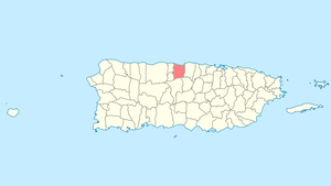 Location of Manatí in Puerto Rico | |
| Coordinates: 18°25′57″N 66°29′4″W | |
| Commonwealth | |
| Founded | 1738 |
| Government | |
| • Mayor | José Sánchez González (PNP) |
| • Senatorial dist. | 3 - Arecibo |
| • Representative dist. | 12, 13 |
| Area | |
| • Total | 145.53 km2 (56.19 sq mi) |
| • Land | 120 km2 (50 sq mi) |
| • Water | 25.53 km2 (9.86 sq mi) |
| Population (2010) | |
| • Total | 44,113 |
| • Density | 300/km2 (790/sq mi) |
| Demonym(s) | Manatieños |
| Time zone | UTC−4 (AST) |
| Zip code | 00674 |
| Major routes | |
History
Manatí was founded in 1799 by Don Pedro Menendez Valdes. The Iglesia Nuestra Señora de la Candelaria church was built in the seventeenth century and is still standing in its original spot.[1] Manati is known as La Ciudad Metropolitana (The Metropolitan City), and also as Las Atenas de Puerto Rico, (The Athens of Puerto Rico).[2] It is named after a sea mammal, the manatee (the sea cow).
During those early years, the mayor of the town was Jose Aulet. Juan Ponce de León picked the Manatí leg of the Manuatabón River as the first area to pan for gold.[1] The Aulet family owned lands rich in pineapples, sugar cane, and green bananas. The Aulets sold the land to the government in 1985.
The United States took control of Puerto Rico from Spain in the aftermath of the Spanish-American War under the terms of the Treaty of Paris of 1898 and conducted its first census of Puerto Rico in 1899, finding that the population of Manatí was 13,989.[3]
In 1853, the region shifted from mining to an expansion of agriculture, particularly cultivation and processing of sugar cane. The demand for and price of sugar remained high in international markets. The main commodity crop was sugar cane. Carpentry also became popular. During that year, the town consisted of 280 homes, 2 squares, 8 streets and a school with 50 pupils.
Hurricane Maria
On September 20, 2017, the lives of Manatí residents were disrupted when Hurricane Maria made landfall in Puerto Rico causing widespread flooding, landslides, and damage to critical infrastructure.[4]
Geography
Manatí is on the northern central coast.[5]
Barrios

Like all municipalities of Puerto Rico, Manatí is subdivided into barrios. The municipal buildings, central square and a large Catholic church are located in the center of the municipality, in a barrio referred to as "el pueblo".[6][7][8][9]
Sectors
Barrios (which are like minor civil divisions)[10] in turn are further subdivided into smaller local populated place areas/units called sectores (sectors in English). The types of sectores may vary, from normally sector to urbanización to reparto to barriada to residencial, among others.[11][12][13]
Special Communities
Of the 742 places on the list of Comunidades Especiales de Puerto Rico, the following barrios, communities, sectors, or neighborhoods were in Manatí: Cerro Gandía, Cerro Quiñones and El Horno.[14]
Demographics
| Historical population | |||
|---|---|---|---|
| Census | Pop. | %± | |
| 1900 | 13,989 | — | |
| 1910 | 17,240 | 23.2% | |
| 1920 | 20,100 | 16.6% | |
| 1930 | 24,838 | 23.6% | |
| 1940 | 29,366 | 18.2% | |
| 1950 | 30,449 | 3.7% | |
| 1960 | 29,354 | −3.6% | |
| 1970 | 30,559 | 4.1% | |
| 1980 | 36,562 | 19.6% | |
| 1990 | 38,692 | 5.8% | |
| 2000 | 45,409 | 17.4% | |
| 2010 | 44,113 | −2.9% | |
| U.S. Decennial Census[15] 1899 (shown as 1900)[16] 1910-1930[17] 1930-1950[18] 1960-2000[19] 2010[8] | |||
Tourism
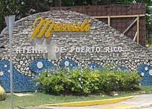
In 2014, Manati welcomed its first hotel, the Hyatt Place Hotel and Casino, located next to Casino Atlántico and a LongHorn Steakhouse, which opened in April 2014. The hotel has an outdoor swimming pool, 3 meeting rooms and a fitness center. The official name was Hyatt Place Manati & Casino. Manati is popular for its beaches and is part of the Porta Altantico tourism district.
In 2019, Manatí began offering free tours of its city, beaches, historic places and eateries.[20][21]
Landmarks and places of interest
Some of the places of interest in Manatí include:[21]
- The Acropolis Sports Complex
- Biblioteca Nacional Francisco Álvarez [1]
- El Salón del Poeta
- Historic Zone
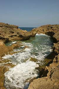
- Los Tubos Beach
- La Esperanza Beach
- Playa Cueva Las Golondrinas, where visitors have been cited for public indecency. Puerto Rico does not have nudist beaches.[22]
- Mar Chiquita Beach[23]
- Marqués de la Esperanza Hacienda Ruins
- Ruinas de la Oficina de la Central Monserrate
- The New Manati Arena
- Manati Baseball Stadium
Economy
Agriculture
Isidoro Colón established the "Candelaria" sugar mill in the years between 1860 and 1870, located between Manatí and Barceloneta. Manatí is the pineapple center of Puerto Rico. In addition in Manatí, there is cultivation of fruits, sugar cane, and coffee.[2] Los Frutos del Guacabo is a farming company in Manatí that provides local fruit and vegetables to local chefs.[24][25]
Industry
The industry of Manatí is shoes, woodwork, and a pineapple cannery as well as pharmaceuticals:[26]
- Bristol-Myers Squibb
- Warner Chilcott
- DuPont
- Patheon
- Actavis (inside W.C)
- Janssen Ortho LLC
Retailers
- Burlington store[27]
Healthcare
Manati has two large, private hospitals, Doctor's Center Hospital, and Manati Medical Center Dr. Otero Lopez (formerly the government owned Hospital de Area). There is also the smaller Municipal Hospital.
The area surrounding PR-2 is known for having many medical offices.
Education
Manati has 3 high schools: Petra Corretjer de O'neill High School, Fernando Callejo High School, and the Escuela Instituto Tecnologico Recinto De Manati, the latter also serving as a technical institute.
Private Schools:
- Colegio Marista "El Salvador" Manati
- Colegio De La Inmaculada
- Piaget Bilingual Academy
- Academia Discipulos de Cristo
- Colegio Hispano Americano
- La Reine Christian Bilingual School
Manati's only university is the American University of Puerto Rico, Manati Campus. There are several technical institutes, such as Instituto de Banca y Comercio, Atenas' College, EDC college and Dewey University.
Transportation
There are 15 bridges in Manatí.[28]
Culture
Festivals and events
- Patron Fetivities - February: "La Virgen De La Candelaria"
- Cross Festivities - May
- Beach Festival - July
- Manatee Festival - July
- Halloween Festival - October
- Christmas Festival - December
Notable natives and residents
Notable people from Manatí include:
- José Miguel Class, singer
- Noel Cuevas, professional baseball player
- Manuel Ramos Otero, poet and LGBT activist
- Carlos Santana Becerra, judge
- Yara Sofia, drag queen
- Antonio Vélez Alvarado, father of the Puerto Rican flag
See also
- List of Puerto Ricans
- History of Puerto Rico
- Did you know-Puerto Rico?
References
- "Manatí, PR - The Athens of Puerto Rico." Eye Tour. 2011. Web. 7 Dec 2011.<http://eyetour.com/blog/manati/ Archived 2011-11-05 at the Wayback Machine>.
- Rivera, Magaly. "Manati" Welcome to Puerto Rico! 7 Dec 2011. <http://www.topuertorico.org/city/manati.shtml>.
- Joseph Prentiss Sanger; Henry Gannett; Walter Francis Willcox (1900). Informe sobre el censo de Puerto Rico, 1899, United States. War Dept. Porto Rico Census Office (in Spanish). Imprenta del gobierno. p. 161.
- Vicens, A. J. "Portraits of suffering and resilience in Puerto Rico six months after Hurricane Maria". Archived from the original on 2019-09-28. Retrieved 2019-09-28.
- "Manatí Municipality". enciclopediapr.org. Fundación Puertorriqueña de las Humanidades (FPH).
- Picó, Rafael; Buitrago de Santiago, Zayda; Berrios, Hector H. Nueva geografía de Puerto Rico: física, económica, y social, por Rafael Picó. Con la colaboración de Zayda Buitrago de Santiago y Héctor H. Berrios. San Juan Editorial Universitaria, Universidad de Puerto Rico,1969. Archived from the original on 2018-12-26. Retrieved 2018-12-31.
- Gwillim Law (20 May 2015). Administrative Subdivisions of Countries: A Comprehensive World Reference, 1900 through 1998. McFarland. p. 300. ISBN 978-1-4766-0447-3. Retrieved 25 December 2018.
- Puerto Rico:2010:population and housing unit counts.pdf (PDF). U.S. Dept. of Commerce Economics and Statistics Administration U.S. Census Bureau. 2010. Archived (PDF) from the original on 2017-02-20. Retrieved 2018-12-26.
- "Map of Manatí at the Wayback Machine" (PDF). Archived from the original (PDF) on 2018-03-24. Retrieved 2018-12-29.
- "US Census Barrio-Pueblo definition". factfinder.com. US Census. Archived from the original on 13 May 2017. Retrieved 5 January 2019.
- "Agencia: Oficina del Coordinador General para el Financiamiento Socioeconómico y la Autogestión (Proposed 2016 Budget)". Puerto Rico Budgets (in Spanish). Retrieved 28 June 2019.
- Rivera Quintero, Marcia (2014), El vuelo de la esperanza: Proyecto de las Comunidades Especiales Puerto Rico, 1997-2004 (first ed.), San Juan, Puerto Rico Fundación Sila M. Calderón, ISBN 978-0-9820806-1-0
- "Leyes del 2001". Lex Juris Puerto Rico (in Spanish). Retrieved 24 June 2020.
- Rivera Quintero, Marcia (2014), El vuelo de la esperanza:Proyecto de las Comunidades Especiales Puerto Rico, 1997-2004 (Primera edición ed.), San Juan, Puerto Rico Fundación Sila M. Calderón, p. 273, ISBN 978-0-9820806-1-0
- "U.S. Decennial Census". United States Census Bureau. Archived from the original on February 13, 2020. Retrieved September 21, 2017.
- "Report of the Census of Porto Rico 1899". War Department Office Director Census of Porto Rico. Archived from the original on July 16, 2017. Retrieved September 21, 2017.
- "Table 3-Population of Municipalities: 1930 1920 and 1910" (PDF). United States Census Bureau. Archived (PDF) from the original on August 17, 2017. Retrieved September 21, 2017.
- "Table 4-Area and Population of Municipalities Urban and Rural: 1930 to 1950" (PDF). United States Census Bureau. Archived (PDF) from the original on August 30, 2015. Retrieved September 21, 2014.
- "Table 2 Population and Housing Units: 1960 to 2000" (PDF). United States Census Bureau. Archived (PDF) from the original on July 24, 2017. Retrieved September 21, 2017.
- "Discovery Manati". Discovery Manati. Archived from the original on 2019-09-28. Retrieved 2019-09-28.
- "Conoce las playas y la naturaleza en Manatí". El Nuevo Dia (in Spanish). August 9, 2019. Archived from the original on September 28, 2019. Retrieved September 28, 2019.
- "Investigan la existencia de una posible playa nudista en Manatí". Univision (in Spanish). Archived from the original on 2019-09-28. Retrieved 2019-09-28.
- "Encaminado un proyecto para declarar reserva ecológica en Mar Chiquita". Primera Hora (in Spanish). March 29, 2019. Archived from the original on September 28, 2019. Retrieved September 28, 2019.
- Modak, Sebastian (February 15, 2019). "Visiting Puerto Rico, and Finding the Up Beat". Archived from the original on September 28, 2019. Retrieved September 28, 2019 – via NYTimes.com.
- "Lanzan primer proyecto del Grupo Interagencial de Impacto Social". Primera Hora (in Spanish). March 25, 2019. Archived from the original on September 28, 2019. Retrieved September 28, 2019.
- https://www.britannica.com/place/Manati
- "Burlington set to re-open 2 additional P.R. stores in Río Piedras, Manatí – News is My Business". News is my Business. Retrieved 20 August 2019.
- "Manati Bridges". National Bridge Inventory Data. US Dept. of Transportation. Archived from the original on 20 February 2019. Retrieved 19 February 2019.