Barranquitas, Puerto Rico
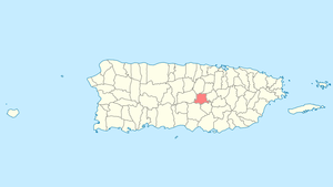
Barranquitas (Spanish pronunciation: [baraŋˈkitas]) is a small mountain municipality located in the central region of Puerto Rico, south of Corozal and Naranjito; north of Coamo and Aibonito; west of Comerío and Cidra; and east of Orocovis. Barranquitas is spread over 6 wards and Barranquitas Pueblo (the downtown area and the administrative center of the city). It is part of the San Juan-Caguas-Guaynabo Metropolitan Statistical Area.
Barranquitas Municipio Autónomo de Barranquitas | |
|---|---|
Town and Municipality | |
 | |
 Flag  Coat of arms | |
| Nicknames: "La Cuna de Próceres", "Cuna Feria de Artesanías", "El Altar de la Patria", "El Pueblo de Luis Muñoz Rivera" | |
| Anthem: "Aquí en el centro de nuestra tierra" | |
 Location of Barranquitas in Puerto Rico | |
| Coordinates: 18°11′12″N 66°18′23″W | |
| Commonwealth | |
| Founded | 1803 |
| Government | |
| • Mayor | Elliot Colón Blanco (PNP) |
| • Senatorial dist. | 6 - Guayama |
| • Representative dist. | 26 and 28 |
| Area | |
| • Total | 33.21 sq mi (86.01 km2) |
| • Land | 33 sq mi (86 km2) |
| • Water | 0.004 sq mi (.01 km2) |
| Population (2010) | |
| • Total | 30,318 |
| • Density | 910/sq mi (350/km2) |
| Demonym(s) | Barranquiteños |
| Time zone | UTC-4 (AST) |
| Zip code | 00794 |
| Major routes | |
| Website | http://barranquitaspr.net/pueblo/ |
Barranquitas is about one hour by winding roads from San Juan, the capital. It is nestled amid hills and mountains, and nearby, between Barranquitas and Aibonito, is located the "cañón de San Cristóbal" (Canyon of Saint Cristopher); one of the deepest canyons in the Indies. For years, the overlook was used as a municipal garbage; in the last decade, the refuse was removed and the site restored.
History
Barranquitas's local Taino Indian Cacique (Chief) was called Orocobix and his yucayeque or tribe was known as the Jatibonicu Taino.
The town was founded in 1803 by Antonio Aponte Ramos.[1] Early in the 20th century, Barranquitas residents, known as Barranquiteños, had a short but legendary territory war with residents of the city of Comerío.
Hurricane Maria
Hurricane Maria on September 20, 2017 triggered numerous landslides in Barranquitas with the significant amount of rainfall.[2][3] Many residents did not receive help for weeks after the hurricane made landfall as entry into the municipality was hampered by downed trees and telephone poles, and landslides.[4]
.jpg) Returning home with water and food provided by FEMA on Oct. 17, 2017
Returning home with water and food provided by FEMA on Oct. 17, 2017.jpg) Returning home with water
Returning home with water.jpg) Elderly were especially vulnerable after Hurricane Maria left the island with no power
Elderly were especially vulnerable after Hurricane Maria left the island with no power.jpg) A resident on a horse after the hurricane
A resident on a horse after the hurricane.jpg) US Army transport vehicle carrying food and water provided by FEMA on Oct. 17, 2017
US Army transport vehicle carrying food and water provided by FEMA on Oct. 17, 2017.jpg) Volunteer distributing water after Hurricane Maria on Oct. 18, 2017
Volunteer distributing water after Hurricane Maria on Oct. 18, 2017
Geography
Barranquitas is a landlocked municipality in the middle of the Cordillera Central of Puerto Rico, which is the main mountain range that crosses the island from west to east. It is bordered by the municipalities of Corozal, Naranjito, Coamo, Aibonito, Orocovis, and Comerío. Barranquitas has a surface area of 34 square miles (88.4 km2).[1]
The terrain is mostly mountainous. Some of the peaks found in the municipality are La Torrecilla and Farallón. Barranquitas is also the site of the San Cristóbal Canyon.[5]
Water features
The following rivers pass through Barranquitas: Río de Barranquitas, Río Grande de Manatí, Piñonas, Río Hondo, and Río Usabón.
There are 14 bridges in Barranquitas.[6]
Barrios
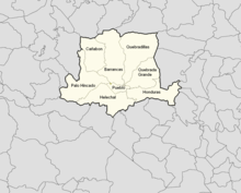
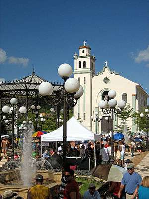
Like all municipalities of Puerto Rico, Barranquitas is subdivided into barrios. The municipal buildings, central square and large Catholic church are located in a small barrio referred to as "el pueblo", near the center of the municipality.[7][8][9][10]
Sectors
Barrios (which are like minor civil divisions)[11] in turn are further subdivided into smaller local populated place areas/units called sectores (sectors in English). The types of sectores may vary, from normally sector to urbanización to reparto to barriada to residencial, among others.[12][13][14]
Special Communities
Of the 742 places on the list of Comunidades Especiales de Puerto Rico, the following barrios, communities, sectors, or neighborhoods are in Barranquitas: El Amparo neighborhood, Cañabón barrio, La Vega neighborhood, Calle Abajo (Calle Melitón Pérez), La Loma, La Torre, Los Pinos, Quebrada Grande barrio, and Tres Caminos.[15]
Energy consortium
An Energy Consortium was signed in late February, 2019 by Villalba, Orocovis, Morovis, Ciales and Barranquitas municipalities. The consortium is the first of its kind for the island. It is intended to have municipalities work together to safeguard and create resilient, and efficient energy networks, with backups for their communities.[16]
Tourism
Landmarks
Barranquitas is the burial place of two prominent Puerto Rican politicians, Luis Muñoz Rivera (who was born in town) and his son, Governor Luis Muñoz Marín (who was born in San Juan). This has made Barranquitas a popular tourist attraction among Puerto Ricans. The birthplace of Muñoz Rivera has been turned into a museum. The mausoleum of the Muñoz Rivera family is another place of interest. Among those buried are Muñoz Rivera and his son and daughter-in-law, Luis Muñoz Marín, and his second wife Inés Mendoza de Muñoz.
Other known places of interest in Barranquitas are the San Cristóbal Canyon, and the ruins of Hacienda Margarita. El Cortijo Castle is an old, historical structure, which is currently a museum. Also, Camp Morton is a popular spot for activities and retirements.
Culture
Festivals and events

Among the annual festivities celebrated in Barranquitas are: Festival del Apio (The Apio Festival) held in April. The apio (from the legume Apios tuberosa) is a plant in the celery family. Festival de la Vega is held in May. The festival held in honor of Saint Anthony of Padua, the town's patron saint, is held in June. The annual Artisans Fair, which has been held in Puerto Rico for over 50 years is held in June.
Sports
Barranquitas has no professional sports teams, but there are some amateur sports teams based in the city. The most popular amateur sport is baseball. The team of Barranquitas is known as the "Proceres" (is an adjective for an important person in history)due to the fact that the town has been the birthplace for many historical figures. The other popular sport is the volleyball.
Economy
Agriculture
.jpg)
Some of the crops grown in Barranquitas are coffee, fruits, and vegetables. The main crop in Barranquitas is the Apio. The Apio is a root vegetable (from the legume Apios tuberosa / Apios Americana), and it is eaten like potatoes. Not to be confused with celeriac.
Industry
Barranquitas manufacturers include footwear and clothing.
Demographics
The United States took control of Puerto Rico from Spain in the aftermath of the Spanish-American War under the terms of the Treaty of Paris of 1898 and conducted its first census of Puerto Rico, finding that the population of Barranquitas was 8,103.
| Historical population | |||
|---|---|---|---|
| Census | Pop. | %± | |
| 1900 | 8,103 | — | |
| 1910 | 10,503 | 29.6% | |
| 1920 | 11,600 | 10.4% | |
| 1930 | 14,901 | 28.5% | |
| 1940 | 17,096 | 14.7% | |
| 1950 | 17,605 | 3.0% | |
| 1960 | 18,978 | 7.8% | |
| 1970 | 20,118 | 6.0% | |
| 1980 | 21,639 | 7.6% | |
| 1990 | 25,605 | 18.3% | |
| 2000 | 28,909 | 12.9% | |
| 2010 | 30,318 | 4.9% | |
| U.S. Decennial Census[17] 1899 (shown as 1900)[18] 1910-1930[19] 1930-1950[20] 1960-2000[21] 2010[9] | |||
Many of the Puerto Ricans born in the town are known to have light-colored eyes and have strong European features. Some also have an apparent mestizo look to them. The reason for this phenomenon is due to the migration of many Taino Indians during the Spanish colonization. Many Tainos fled to the mountainous region to escape slavery. Many poor Spanish and other European immigrants moved to this region as well and settled as coffee growers. Eventually, the Taino and European immigrants intermarried and created what is called the "mestizo".
Government
All municipalities in Puerto Rico are administered by a mayor, elected every four years. The current mayor of Barranquitas is Francisco López, of the New Progressive Party (PNP). He was elected at the 1996 general elections, and re-elected for the last 4 general elections.
The city belongs to the Puerto Rico Senatorial district VI, which is represented by two Senators. In 2012, Miguel Pereira Castillo and Angel M. Rodríguez were elected as District Senators.[22]
Education
All schools in Puerto Rico are administered by the Puerto Rico Department of Education. The schools located in Barranquitas are the following:[23] Many of the schools in Barranquitas educate children on agriculture and cultivating crops.[24]
| School | Level | Ward | Public | Location(s) | Coords |
|---|---|---|---|---|---|
| Escuela La Torre | K-6 | Cañabón | Yes | Carr 770 km 2 (mile marker 1.2) Hm 1 (yard marker 110) Sector La Torre | |
| Escuela Cañabón Abajo | K-6 | Barrancas | Yes | Carr 172 | |
| Escuela Mana Abajo | K-6 | Barrancas | Yes | Carr 771 km 9 (mile marker 5.6) Hm 2 (yard marker 220) Sector Mana Abajo | |
| Escuela El Portón | K-6 | Honduras | Yes | Carr 156 km 17 (mile marker 11) Hm 7 (yard marker 770) Sector El Portón | |
| Escuela El Farallón | K-6 | Quebradillas | Yes | Carr 152 km 7 (mile marker 4.3) Hm 6 (yard marker 660) | |
| Escuela Sinforoso Aponte | K-6 | Quebradillas | Yes | Carr 152 km 7 (mile marker 4.3) Hm 6 (yard marker 660) | |
| Escuela Petroamérica Pagán | K-6 | Pueblo | Yes | Calle Muñoz Rivera #14 | |
| Escuela La Vega (Stephen S. Huse) | K-6 | Pueblo | Yes | Carr 771 km 0 (mile marker 0) Hm 3 (yard marker 330) Bda La Vega | |
| Escuela S.U. Palo Hincado (Federico Degetau) | K-9 | Palo Hincado | Yes | Carr 156 km 11 (mile marker 6.8) Hm 4 (yard marker 440) | |
| Escuela S.U. La Loma (Antonio Vázquez Ramos) | K-9 | Quebrada Grande | Yes | Carr 156 km 20 (mile marker 12) Hm 1 (yard marker 110) | |
| Escuela S.U. Helechal | K-9 | Helechal | Yes | Carr 162 km 7 (mile marker 4.3) Hm 4 (yard marker 440) | |
| Escuela S.U. Lajitas (Ramon T Rivera) | K-9 | Barrancas | Yes | Carr 771 km 5 (mile marker 3.1) Hm 4 (yard marker 440) | |
| Escuela Pedro Laboy | 7-9 | Quebradillas | Yes | Carr 152 km 6 (mile marker 3.7) Hm 5 (yard marker 550) | |
| Escuela José Berríos Berdecia | 7-9 | Pueblo | Yes | Calle Melitón Pereles | |
| Escuela Pablo Colón Berdecia (Superior Vocational) | 10-12 | Pueblo | Yes | Calle Barcelo Final | |
| Escuela Luis Muñoz Marín (Superior Commerce) | 10-12 | Quebradillas | Yes | Calle A Sector Nuevo | |
| San Francisco de Asís School | K-9 | Helechal | No | Carr 719 km 2 (mile marker 1.2) Hm 5 (yard marker 550) Sector Hoya Honda |
References
- "Barranquitas Municipality". enciclopediapr.org. Fundación Puertorriqueña de las Humanidades (FPH).
- "Preliminary Locations of Landslide Impacts from Hurricane Maria, Puerto Rico". USGS Landslide Hazards Program. USGS. Archived from the original on 2019-03-03. Retrieved 2019-03-03.
- "Preliminary Locations of Landslide Impacts from Hurricane Maria, Puerto Rico" (PDF). USGS Landslide Hazards Program. USGS. Archived (PDF) from the original on 2019-03-03. Retrieved 2019-03-03.
- https://www.vice.com/en_us/article/ywn59b/what-its-like-delivering-aid-to-a-remote-town-in-puerto-rico
- https://www.gettyimages.co.uk/detail/video/view-of-waterfall-at-san-cristobal-canyon-puerto-rico-stock-footage/654910921
- "Barranquitas Bridges". National Bridge Inventory Data. US Dept. of Transportation. Archived from the original on 20 February 2019. Retrieved 19 February 2019.
- Picó, Rafael; Buitrago de Santiago, Zayda; Berrios, Hector H. Nueva geografía de Puerto Rico: física, económica, y social, por Rafael Picó. Con la colaboración de Zayda Buitrago de Santiago y Héctor H. Berrios. San Juan Editorial Universitaria, Universidad de Puerto Rico,1969. Archived from the original on 2018-12-26. Retrieved 2019-01-04.
- Gwillim Law (20 May 2015). Administrative Subdivisions of Countries: A Comprehensive World Reference, 1900 through 1998. McFarland. p. 300. ISBN 978-1-4766-0447-3. Retrieved 25 December 2018.
- Puerto Rico:2010:population and housing unit counts.pdf (PDF). U.S. Dept. of Commerce Economics and Statistics Administration U.S. Census Bureau. 2010. Archived (PDF) from the original on 2017-02-20. Retrieved 2018-12-28.
- "Map of Barranquitas at the Wayback Machine" (PDF). Archived from the original (PDF) on 2018-03-24. Retrieved 2018-12-29.
- "US Census Barrio-Pueblo definition". factfinder.com. US Census. Archived from the original on 13 May 2017. Retrieved 5 January 2019.
- "Agencia: Oficina del Coordinador General para el Financiamiento Socioeconómico y la Autogestión (Proposed 2016 Budget)". Puerto Rico Budgets (in Spanish). Retrieved 28 June 2019.
- Rivera Quintero, Marcia (2014), El vuelo de la esperanza: Proyecto de las Comunidades Especiales Puerto Rico, 1997-2004 (first ed.), San Juan, Puerto Rico Fundación Sila M. Calderón, ISBN 978-0-9820806-1-0
- "Leyes del 2001". Lex Juris Puerto Rico (in Spanish). Retrieved 24 June 2020.
- Rivera Quintero, Marcia (2014), El vuelo de la esperanza:Proyecto de las Comunidades Especiales Puerto Rico, 1997-2004 (Primera edición ed.), San Juan, Puerto Rico Fundación Sila M. Calderón, p. 273, ISBN 978-0-9820806-1-0
- Vazquez, Priscilla. "Asociación de Industriales de Puerto Rico". Industriales Puerto Rico. Archived from the original on 2019-03-12. Retrieved 2019-03-16.
- "U.S. Decennial Census". United States Census Bureau. Archived from the original on February 13, 2020. Retrieved September 21, 2017.
- "Report of the Census of Porto Rico 1899". War Department Office Director Census of Porto Rico. Archived from the original on July 16, 2017. Retrieved September 21, 2017.
- "Table 3-Population of Municipalities: 1930 1920 and 1910" (PDF). United States Census Bureau. Archived (PDF) from the original on August 17, 2017. Retrieved September 21, 2017.
- "Table 4-Area and Population of Municipalities Urban and Rural: 1930 to 1950" (PDF). United States Census Bureau. Archived (PDF) from the original on August 30, 2015. Retrieved September 21, 2014.
- "Table 2 Population and Housing Units: 1960 to 2000" (PDF). United States Census Bureau. Archived (PDF) from the original on July 24, 2017. Retrieved September 21, 2017.
- Elecciones Generales 2012: Escrutinio General Archived 2012-11-27 at the Wayback Machine on CEEPUR
- "Archived copy". Archived from the original on 2012-01-11. Retrieved 2011-07-19.CS1 maint: archived copy as title (link)
- https://www.fortaleza.pr.gov/content/gobernador-rossell-nevares-respalda-proyecto-agr-cola-estudiantil-en-barranquitas