Karst
Karst is a topography formed from the dissolution of soluble rocks such as limestone, dolomite, and gypsum. It is characterized by underground drainage systems with sinkholes and caves.[1] It has also been documented for more weathering-resistant rocks, such as quartzite, given the right conditions.[2] Subterranean drainage may limit surface water, with few to no rivers or lakes. However, in regions where the dissolved bedrock is covered (perhaps by debris) or confined by one or more superimposed non-soluble rock strata, distinctive karst features may occur only at subsurface levels and can be totally missing above ground.
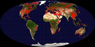
.jpg)
The study of karst is considered of prime importance in petroleum geology because as much as 50% of the world's hydrocarbon reserves are hosted in porous karst systems.[3]
Etymology
The English word karst was borrowed from German Karst in the late 19th century,[4] which entered German much earlier.[5] According to one interpretation the term is derived from the German name for a number of geological, geomorphological, and hydrological features found within the range of the Dinaric Alps, stretching from the northeastern corner of Italy above the city of Trieste (at the time part of the Austrian Littoral), across the Balkan peninsula along the coast of the eastern Adriatic to Kosovo and North Macedonia, where the massif of the Šar Mountains begins, and more specifically the karst zone at the northwestern-most section, described in early topographical research as a plateau, between Italy and Slovenia.
In the local South Slavic languages, all variations of the word are derived from a Romanized Illyrian base (yielding Latin: carsus, Dalmatian Romance carsus), later metathesized from the reconstructed form *korsъ into forms such as Slovene: kras[6] and Serbo-Croatian: krš, kras.[7][8][9][10] Languages preserving the older, non-metathesized form include Italian: Carso, German: Karst, and Albanian: karsti; the lack of metathesis precludes borrowing from any of the South Slavic languages, specifically Slovene.[11][12] The Slovene common noun kras was first attested in the 18th century, and the adjective form kraški in the 16th century.[13] As a proper noun, the Slovene form Grast was first attested in 1177.[14]
Ultimately, the word is of Mediterranean origin. It has been suggested that the word may derive from the Proto-Indo-European root karra- 'rock'.[15] The name may also be connected to the oronym Kar(u)sádios oros cited by Ptolemy, and perhaps also to Latin Carusardius.[13][14]
Early studies

Johann Weikhard von Valvasor, a pioneer of the study of karst in Slovenia and a fellow of the Royal Society for Improving Natural Knowledge, London, introduced the word karst to European scholars in 1689, describing the phenomenon of underground flows of rivers in his account of Lake Cerknica.[16]
Jovan Cvijić greatly advanced the knowledge of karst regions, so much that he became known as the "father of karst geomorphology". Primarily discussing the karstic regions of the Balkans, Cvijić's 1893 publication Das Karstphänomen describes landforms such as karren, dolines and poljes.[3] In a 1918 publication, Cvijić proposed a cyclical model for karstic landscape development.[3][17] Karst hydrology emerged as a discipline in the late 1950s and early 1960s in France. Previously, the activities of cave explorers, called speleologists, had been dismissed as more of a sport than a science, meaning that underground karstic caves and their associated watercourses were, from a scientific perspective, understudied.[18]
Chemistry
The development of karst occurs whenever acidic water starts to break down the surface of bedrock near its cracks, or bedding planes. As the bedrock (typically limestone or dolomite) continues to degrade, its cracks tend to get bigger. As time goes on, these fractures will become wider, and eventually a drainage system of some sort may start to form underneath. If this underground drainage system does form, it will speed up the development of karst formations there because more water will be able to flow through the region, giving it more erosive power.[19]
Dissolution mechanism
The carbonic acid that causes karstic features is formed as rain passes through Earth's atmosphere picking up carbon dioxide (CO2), which dissolves in the water. Once the rain reaches the ground, it may pass through soil that can provide much more CO2 to form a weak carbonic acid solution, which dissolves calcium carbonate. The primary reaction sequence in limestone dissolution is the following:
H2O + CO2 → H2CO3 CaCO3 + H2CO3 → Ca2+ + 2 HCO−
3

In particular and very rare conditions such as encountered in the past in Lechuguilla Cave in New Mexico (and more recently in the Frasassi Caves in Italy), other mechanisms may also play a role. The oxidation of sulfides leading to the formation of sulfuric acid can also be one of the corrosion factors in karst formation. As oxygen (O2)-rich surface waters seep into deep anoxic karst systems, they bring oxygen, which reacts with sulfide present in the system (pyrite or hydrogen sulfide) to form sulfuric acid (H2SO4). Sulfuric acid then reacts with calcium carbonate, causing increased erosion within the limestone formation. This chain of reactions is:
H2S + 2 O2 → H2SO4 (sulfide oxidation) H2SO4 + 2 H2O → SO2−
4+ 2 H3O+ (sulfuric acid dissociation) CaCO3 + 2 H3O+ → Ca2+ + H2CO3 + 2 H2O (calcium carbonate dissolution) Ca2+ + SO42- → CaSO4 (formation of calcium sulfate) CaSO4 + 2 H2O → CaSO4 · 2 H2O (formation of gypsum)
Morphology
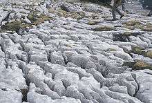
The karstification of a landscape may result in a variety of large- or small-scale features both on the surface and beneath. On exposed surfaces, small features may include solution flutes (or rillenkarren), runnels, limestone pavement (clints and grikes), collectively called karren or lapiez. Medium-sized surface features may include sinkholes or cenotes (closed basins), vertical shafts, foibe (inverted funnel shaped sinkholes), disappearing streams, and reappearing springs. Large-scale features may include limestone pavements, poljes, and karst valleys. Mature karst landscapes, where more bedrock has been removed than remains, may result in karst towers, or haystack/eggbox landscapes. Beneath the surface, complex underground drainage systems (such as karst aquifers) and extensive caves and cavern systems may form.
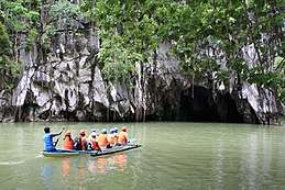
Erosion along limestone shores, notably in the tropics, produces karst topography that includes a sharp makatea surface above the normal reach of the sea, and undercuts that are mostly the result of biological activity or bioerosion at or a little above mean sea level. Some of the most dramatic of these formations can be seen in Thailand's Phangnga Bay and at Halong Bay in Vietnam.
Calcium carbonate dissolved into water may precipitate out where the water discharges some of its dissolved carbon dioxide. Rivers which emerge from springs may produce tufa terraces, consisting of layers of calcite deposited over extended periods of time. In caves, a variety of features collectively called speleothems are formed by deposition of calcium carbonate and other dissolved minerals.
Hydrology
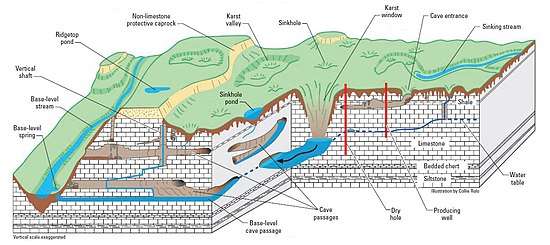
Farming in karst areas must take into account the lack of surface water. The soils may be fertile enough, and rainfall may be adequate, but rainwater quickly moves through the crevices into the ground, sometimes leaving the surface soil parched between rains.
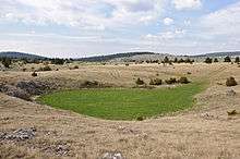
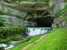
A karst fenster (karst window) occurs when an underground stream emerges onto the surface between layers of rock, cascades some distance, and then disappears back down, often into a sinkhole. Rivers in karst areas may disappear underground a number of times and spring up again in different places, usually under a different name (like Ljubljanica, the river of seven names). An example of this is the Popo Agie River in Fremont County, Wyoming. At a site simply named "The Sinks" in Sinks Canyon State Park, the river flows into a cave in a formation known as the Madison Limestone and then rises again 800 m (1⁄2 mi) down the canyon in a placid pool. A turlough is a unique type of seasonal lake found in Irish karst areas which are formed through the annual welling-up of water from the underground water system.
Water supplies from wells in karst topography may be unsafe, as the water may have run unimpeded from a sinkhole in a cattle pasture, through a cave and to the well, bypassing the normal filtering that occurs in a porous aquifer. Karst formations are cavernous and therefore have high rates of permeability, resulting in reduced opportunity for contaminants to be filtered. Groundwater in karst areas is just as easily polluted as surface streams. Sinkholes have often been used as farmstead or community trash dumps. Overloaded or malfunctioning septic tanks in karst landscapes may dump raw sewage directly into underground channels.
The karst topography also poses difficulties for human inhabitants. Sinkholes can develop gradually as surface openings enlarge, but progressive erosion is frequently unseen until the roof of a cavern suddenly collapses. Such events have swallowed homes, cattle, cars, and farm machinery. In the United States, sudden collapse of such a cavern-sinkhole swallowed part of the collection of the National Corvette Museum in Bowling Green, Kentucky in 2014.[21]
Interstratal karst
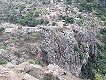
Interstratal karst is a karstic landscape which is developed beneath a cover of insoluble rocks. Typically this will involve a cover of sandstone overlying limestone strata undergoing solution. In the United Kingdom for example extensive doline fields have developed at Cefn yr Ystrad, Mynydd Llangatwg and Mynydd Llangynidr in South Wales across a cover of Twrch Sandstone which overlies concealed Carboniferous Limestone, the last-named having been declared a site of special scientific interest in respect of it.[22]
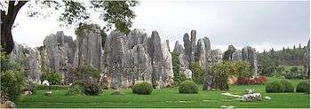
Kegelkarst
Kegelkarst is a type of tropical karst terrain with numerous cone-like hills, formed by cockpits, mogotes, and poljes and without strong fluvial erosion processes. This terrain is found in Cuba, Jamaica, Indonesia, Malaysia, the Philippines, Puerto Rico, southern China, Myanmar, Thailand, Laos and Vietnam.[23]
Pseudokarst
Pseudokarsts are similar in form or appearance to karst features but are created by different mechanisms. Examples include lava caves and granite tors—for example, Labertouche Cave in Victoria, Australia—and paleocollapse features. Mud Caves are an example of pseudokarst.
Paleokarst
Paleokarst or palaeokarst is a development of karst observed in geological history and preserved within the rock sequence, effectively a fossil karst. There are for example palaeokarstic surfaces exposed within the Clydach Valley Subgroup of the Carboniferous Limestone sequence of South Wales which developed as sub-aerial weathering of recently formed limestones took place during periods of non-deposition within the early part of the period. Sedimentation resumed and further limestone strata were deposited on an irregular karstic surface, the cycle recurring several times in connection with fluctuating sea levels over prolonged periods.[24]
Karst areas
The world's largest limestone karst is Australia's Nullarbor Plain. Slovenia has the world's highest risk of sinkholes, while the western Highland Rim in the eastern United States is at the second-highest risk of karst sinkholes.[25][26]
Mexico hosts important karstic regions in the Yucatán Peninsula and Chiapas.[27]
The South China Karst in the provinces of Guizhou, Guangxi, and Yunnan provinces is a UNESCO World Heritage Site.
The Tham Luang Nang Non karstic cave system in northern Thailand was made famous by the 2018 rescue of a junior football team.
List of terms for karst-related features
- Abîme, a vertical shaft in karst that may be very deep and usually opens into a network of subterranean passages
- Cenote, a deep sinkhole, characteristic of Mexico, resulting from collapse of limestone bedrock that exposes groundwater underneath
- Doline, also sink or sinkhole, is a closed depression draining underground in karst areas. The name "doline" comes from dolina, meaning "valley", and derives from South Slavic languages.
- Foibe, an inverted funnel-shaped sinkhole
- Karst fenster ("karst window"), a feature where a spring emerges briefly, with the water discharge then abruptly disappearing into a nearby sinkhole
- Karst spring, a spring emerging from karst, originating a flow of water on the surface
- Limestone pavement, a landform consisting of a flat, incised surface of exposed limestone that resembles an artificial pavement
- Losing stream, sinking river or ponornica in South Slavic languages.
- Polje (karst polje, karst field), a large flat specifically karstic plain. The name "polje" derives from South Slavic languages.
- Ponor, same as estavelle, sink or sinkhole in South Slavic languages, where surface flow enters an underground system
- Scowle, porous irregular karstic landscape in a region of England.
- Turlough (turlach), a type of disappearing lake characteristic of Irish karst.
- Uvala, a collection of multiple smaller individual sinkholes that coalesce into a compound sinkhole. The term derives from South Slavic languages (many karst-related terms derive from South Slavic languages, entering scientific vocabulary through early research in the Western Balkan Dinaric Alpine karst).
See also
- Glaciokarst – A karst landscape that was glaciated during the cold periods of the Pleistocene
- Karstjäger
- List of landforms – Links to Wikipedia articles on landforms
- Scowle – Landscape features which range from amorphous shallow pits to irregular labyrinthine hollows up to several metres deep
- Speleology – Science of cave and karst systems
- Subterranean river – A river that runs wholly or partly beneath the ground surface
- Thermokarst – A land surface with very irregular surfaces of marshy hollows and small hummocks formed as ice-rich permafrost thaws
References
- "What is Karst?". May 16, 2006. Archived from the original on May 16, 2006. Retrieved Dec 31, 2019.
- Geomorphological Landscapes of the World.
- Ford, Derek (2007). "Jovan Cvijić and the founding of karst geomorphology". Environmental Geology. 51: 675–684. doi:10.1007/s00254-006-0379-x.
- Shorter Oxford English Dictionary. 2002. Vol. 1, A–M. Oxford: Oxford University Press, p. 1481.
- Seebold, Elmar. 1999. Kluge Etymologisches Wörterbuch der Deutschen Sprache, 23rd edition. Berlin: Walter de Gruyter, p. 429.
- Jernej Pavšič (2006). Geološki terminološki slovar (in Slovenian). Založba ZRC. p. 142. ISBN 978-961-6568-84-5. Retrieved 15 June 2020.
- Šegota, Tomislav (25 January 2009). "Krš ili kras? Krš! - Geografija.hr". Geografija.hr (in Croatian). Archived from the original on 3 November 2018. Retrieved 30 October 2018.
- Matas, Mate (7 June 2004). "Veliki krš oko krša u jeziku - Geografija.hr". Geografija.hr (in Croatian). Retrieved 30 October 2018.
- Roglić, Josip (1974). Krš Jugoslavije (Volume 9/1 ed.). Zagreb: JAZU Jugoslovenska Akademija Znanosti i Umjetnosti. p. 29.
- "karst | Search Online Etymology Dictionary". www.etymonline.com. Retrieved Dec 31, 2019.
- Pfeiffer, Dieter. 1961. "Zur Definition von Begriffen der Karst-Hydrologie." Zeitschrift der Deutschen Geologischen Gesellschaft 113: 51–60, p. 52
- Pörtner, Rudolf. 1986. Bevor die Römer kamen: Städte und Stätten deutscher Urgeschichte. Rasatt: Pabel-Moewig Verlag, p. 88.
- Snoj, Marko (2003). Slovenski etimološki slovar. Ljubljana: Modrijan. p. 318.
- Bezlaj, France (ed.). 1982. Etimološki slovar slovenskega jezika, vol. 2, K–O. Ljubljana: SAZU, p. 82.
- Gams, I., Kras v Sloveniji — v prostoru in casu (Karst in Slovenia in space and time), 2003, ISBN 961-6500-46-5.
- Paul Larsen, Scientific accounts of a vanishing lake: Janez Valvasor, Lake Cerknica and the New Philosophy, 2003.
- Cvijić, Jovan (1918). "Hydrographie souterraine et évolution morphologique du Karst". Recueil des travaux de l'institut de géographie alpine (in French). 6 (4): 375–426. doi:10.3406/rga.1918.4727.
- Gilli, Éric; Mangan, Christian; Mudry, Jacques (2012). Hydrogeology: Objectives, Methods, Applications. Translated by Fandel, Choél. CRC Press. p. 7.
- "What is Karst (and why is it important)?". Karst Waters Institute.
- Galdenzi, S.; Cocchioni, M.; Morichetti, L.; Amici, V.; Scuri, S. (2008). "Sulfidic ground water chemistry in the Frasassi Cave, Italy" (PDF). Journal of Cave and Karst Studies. 70 (2): 94–107.
- Patterson, Thom. "Mood somber, repairs uncertain as Corvette museum opens". CNN. Retrieved 2019-08-26.
- "Archived copy" (PDF). Archived from the original (PDF) on 2015-11-20. Retrieved 2013-03-03.CS1 maint: archived copy as title (link)
- Whittow, John (1984). Dictionary of Physical Geography. London: Penguin, 1984, p 292. ISBN 0-14-051094-X.
- Howells, M.F (2007). British Regional Geology:Wales. Keyworth, Nottingham: British Geological Survey. p. 118. ISBN 978 085272584 9.
- "Austin Peay State University : Harned Bowl work not to blame for new sinkhole, say experts". May 22, 2014. Archived from the original on May 22, 2014. Retrieved Dec 31, 2019.
- "What is Karst topography and why should you care?". Feb 25, 2009. Retrieved Dec 31, 2019.
- Mora, L.; Bonifaz, R.; López-Martínez, R. (2016). "Unidades geomorfológicas de la cuenca del Río Grande de Comitán, Lagos de Montebello, Chiapas-México". Boletín de la Sociedad Geológica Mexicana (in Spanish). 68 (3): 377–394. doi:10.18268/BSGM2016v68n3a1.
Further reading
- Ford, D.C., Williams, P., Karst Hydrogeology and Geomorphology, John Wiley and Sons Ltd., 2007, ISBN 978-0-470-84996-5
- Jennings, J.N., Karst Geomorphology, 2nd ed., Blackwell, 1985, ISBN 0-631-14032-8
- Palmer, A.N., Cave Geology, 2nd Printing, Cave Books, 2009, ISBN 978-0-939748-66-2
- Sweeting, M.M., Karst Landforms, Macmillan, 1973, ISBN 0-231-03623-X
- van Beynen, P. (Ed.), Karst management, Springer, 2011, ISBN 978-94-007-1206-5
- Vermeulen, J.J., Whitten, T., "Biodiversity and Cultural Property in the Management of Limestone Resources in East Asia: Lessons from East Asia", The World Bank, 1999, ISBN 978-0-821345-08-5
External links
| Wikimedia Commons has media related to: |
| Wikisource has the text of the 1911 Encyclopædia Britannica article Karst. |
- Speleogenesis Network, a communication platform for physical speleology and karst science research
- Speleogenesis and Karst Aquifers – a large glossary of Karst related terms
- Acta Carsologica – research papers and reviews in all the fields related to karst
- CDK Citizens of the Karst – Citizens of the Karst, a non profit NGO dedicated to the protection of the Puerto Rican Karst (English site available)
- The Virtual Cave's page on karst landforms
- Karst Information Portal - an open-access digital library linking scientists, managers, and explorers