Salinas, Puerto Rico
Salinas (Spanish pronunciation: [saˈlinas]) is a municipality in the southern part of Puerto Rico located in the southern coast of the island, south of Aibonito and Cayey; southeast of Coamo, east of Santa Isabel; and west of Guayama. Salinas is spread over 5 wards and Salinas Pueblo (the downtown area and the administrative center of the city).
Salinas Municipio de Salinas | |
|---|---|
Town and Municipality | |
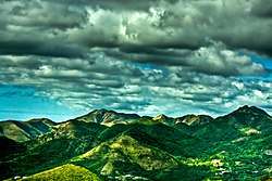 Cordillera Central as seen from Salinas | |
 Flag  Coat of arms | |
| Nicknames: "El Pueblo del Mojo Isleño", "Cuna del Mojito Isleño", "Los Marlins" | |
| Anthem: "Salinas" | |
 Location of Salinas in Puerto Rico | |
| Coordinates: 17.9774659°N 66.2979460°W | |
| Commonwealth | |
| Founded | July 22, 1851 |
| Government | |
| • Mayor | Karilyn Bonilla Colón (PPD) |
| • Senatorial dist. | 6 - Guayama |
| • Representative dist. | 30 |
| Area | |
| • Total | 69.7 sq mi (180.4 km2) |
| Population (2010) | |
| • Total | 31,078 |
| • Density | 450/sq mi (170/km2) |
| • Racial groups (2000 Census) [1] | 74.6%White 10.6% Black 0.4% American Indian/AN 0.1% Asian 0.1% Native Hawaiian/PI 9.8% Some other race 4.5% Two or more races |
| Demonym(s) | Salinenses |
| Time zone | UTC-4 (AST) |
| Zip code | 00751 |
| Area code | 787 |
| Major routes | |
It has long been a fishing spot for Puerto Ricans, known for its beaches, fish variety and the birthplace of the famous "mojito isleño".
Although Salinas doesn't have any commercial airports, there is a military training area there. Camp Santiago, which is Puerto Rico National Guard training center. Army National Guard, Air National Guard, State Guard, U.S. Army ROTC, U.S. Army Reserve and the U.S. Army conduct military training at Camp Santiago.
Salinas is also home to Miss Universe 2006, Zuleyka Rivera and to the former World Boxing Association Welterweight champion of the world, Angel Espada.
History
Salinas was founded in July 22, 1851 by Don Agustín Colón Pacheco as Mayor, Don Jose Maria Cadavedo as Sargent of Arms, Don Juan Colon as Captain of the Civil Guard and five hacendados which were Don Antonio Semidey, Don Antonio Morelli, Don Francisco Secola, Don Julio Delannoy and Don Jose Antonio Torres.
Geography
_as_seen_from_PR-52_NB_Rest_area_at_km_49.0_(DSC00798).jpg)
Salinas is on the southern coast.[2]
- Gorges: The Callao, La Palma y Majada and Pasto Viejo.
- Lagoons: Mar Negro and Punta Arctias.
- Rivers: Río Jájome, Río Jueyes, Río Lapa and Río Nigua (Río Salina).
- Mountains: Cerro Las Tetas.
Barrios

Like all municipalities of Puerto Rico, Salinas is subdivided into barrios. The municipal buildings, central square and large Catholic church are located in a barrio referred to as "el pueblo".[3][4][5][6]
Sectors
Barrios (which are like minor civil divisions)[7] in turn are further subdivided into smaller local populated place areas/units called sectores (sectors in English). The types of sectores may vary, from normally sector to urbanización to reparto to barriada to residencial, among others.[8][9][10]
Special Communities
Of the 742 places on the list of Comunidades Especiales de Puerto Rico, the following barrios, communities, sectors, or neighborhoods are in Salinas: Las Mareas, Playita, Comunidad Aguirre, El Coquí, Parcelas Vázquez, San Felipe, Sector Borinquén, and Sector Villa Cofresí.[11]
Economy
Agriculture
Salinas is one of the main agricultural producers on the southern coast of Puerto Rico. It has large banana and papaya farms in its Lapa and Aguirre barrios. The Río Jueyes barrio is one of the main producers of beef in the south, counting with La Hacienda Las Carolinas which supplies Ganaderia Santiago, a slaughter house, with meat. Salinas also is headquarters for Canto Alegre, a company which specializes in poultry. This company supplies most of Puerto Rico's supermarkets with fresh poultry.
Business
- Apparel, commercial fishing.
Industry
The Aguirre Sugar Cane Mill was the last operational sugar cane mill in Puerto Rico, and closed its doors in 1993. The Central Aguirre Historic District is listed on the National Register of Historic places but there are no current plans to renovate the area, and is now mostly in ruins.[12] Some other industries in Salinas include electrical and electronic machinery, plastics, sunglasses.
Tourism
Landmarks and places of interest

There are 17 beaches in Salinas.[13] Some of Salina's main attractions are:
- Albergue Olímpico (Olympic Hostel), is a sports complex and hostel with air conditioned rooms.[14]
- Antigua Central Aguirre (Sugar Cane Mill)
- Camp Santiago
- Sports Museum
- Playa Salinas
Culture
Festivals and events
- Abey Carnival - February
- Abey - Cacique (Chief) of yucayeque-(village) in the area of Abeyno Salinas, Puerto Rico.
- Pescao Festival - June
- Matron Celebration - September
- Festival Del Mojo Isleño
Demographics
The United States took control of Puerto Rico from Spain in the aftermath of the Spanish-American War under the terms of the Treaty of Paris of 1898 and conducted its first census of Puerto Rico, finding that the population of Salinas was 5,731.
| Historical population | |||
|---|---|---|---|
| Census | Pop. | %± | |
| 1900 | 5,731 | — | |
| 1910 | 11,403 | 99.0% | |
| 1920 | 12,971 | 13.8% | |
| 1930 | 15,446 | 19.1% | |
| 1940 | 19,400 | 25.6% | |
| 1950 | 23,435 | 20.8% | |
| 1960 | 23,133 | −1.3% | |
| 1970 | 21,837 | −5.6% | |
| 1980 | 26,438 | 21.1% | |
| 1990 | 28,335 | 7.2% | |
| 2000 | 31,113 | 9.8% | |
| 2010 | 31,078 | −0.1% | |
| U.S. Decennial Census[15] 1899 (shown as 1900)[16] 1910-1930[17] 1930-1950[18] 1960-2000[19] 2010[5] | |||
| Race - Salinas, Puerto Rico - 2000 Census[20] | ||
|---|---|---|
| Race | Population | % of Total |
| White | 4,645 | 74.6% |
| Black/African American | 647 | 10.6% |
| American Indian and Alaska Native | 29 | 0.4% |
| Asian | 8 | 0.1% |
| Native Hawaiian/Pacific Islander | 2 | 0.1% |
| Some other race | 599 | 9.8% |
| Two or more races | 211 | 4.5% |
Government
All municipalities in Puerto Rico are administered by a mayor, elected every four years. Karilyn Bonilla Colón (of the Popular Democratic Party) was elected as mayor at the 2012 general election, succeeding Carlos Rodríguez Mateo.
The city belongs to the Puerto Rico Senatorial district VI, which is represented by two Senators. In 2012, Miguel Pereira Castillo and Angel M. Rodríguez were elected as District Senators.[21]
Transportation
There are 41 bridges in Salinas.[22]
Symbols
Flag
On a green rectangular field, five white isosceles triangles equal in size, placed in the center of the flag and forming a row that covers the extent of the background. The green represents the land and the triangles hills of salt from which the name of the town is derived.
Coat of arms
The shield uses the traditional colors of the town; green and silver. The salt knolls indicate in graphical form the name of the town: Salinas. The fish refer to the fishing. The sugar cane leaves that surround the shield, symbolize the sugar cane plantations.
Gallery
 Trees in Salinas
 Beach in Salinas
See also
- List of Puerto Ricans
- History of Puerto Rico
- Did you know-Puerto Rico?
References
- "Demographics/Ethnic U.S 2000 census" (PDF). Archived (PDF) from the original on 16 February 2008. Retrieved 15 June 2019.
- "Salinas Municipality". enciclopediapr.org. Fundación Puertorriqueña de las Humanidades (FPH). Archived from the original on 2019-04-04. Retrieved 2019-03-20.
- Picó, Rafael; Buitrago de Santiago, Zayda; Berrios, Hector H. Nueva geografía de Puerto Rico: física, económica, y social, por Rafael Picó. Con la colaboración de Zayda Buitrago de Santiago y Héctor H. Berrios. San Juan Editorial Universitaria, Universidad de Puerto Rico,1969. Archived from the original on 2018-12-26. Retrieved 2019-01-01.
- Gwillim Law (20 May 2015). Administrative Subdivisions of Countries: A Comprehensive World Reference, 1900 through 1998. McFarland. p. 300. ISBN 978-1-4766-0447-3. Retrieved 25 December 2018.
- Puerto Rico:2010:population and housing unit counts.pdf (PDF). U.S. Dept. of Commerce Economics and Statistics Administration U.S. Census Bureau. 2010. Archived (PDF) from the original on 2017-02-20. Retrieved 2018-12-26.
- "Map of Salinas at the Wayback Machine" (PDF). Archived from the original (PDF) on 2018-03-24. Retrieved 2018-12-29.
- "US Census Barrio-Pueblo definition". factfinder.com. US Census. Archived from the original on 13 May 2017. Retrieved 5 January 2019.
- "Agencia: Oficina del Coordinador General para el Financiamiento Socioeconómico y la Autogestión (Proposed 2016 Budget)". Puerto Rico Budgets (in Spanish). Retrieved 28 June 2019.
- Rivera Quintero, Marcia (2014), El vuelo de la esperanza: Proyecto de las Comunidades Especiales Puerto Rico, 1997-2004 (first ed.), San Juan, Puerto Rico Fundación Sila M. Calderón, ISBN 978-0-9820806-1-0
- "Leyes del 2001". Lex Juris Puerto Rico (in Spanish). Retrieved 24 June 2020.
- Rivera Quintero, Marcia (2014), El vuelo de la esperanza:Proyecto de las Comunidades Especiales Puerto Rico, 1997-2004 (Primera edición ed.), San Juan, Puerto Rico Fundación Sila M. Calderón, p. 273, ISBN 978-0-9820806-1-0
- "The Ruins of Central Aguirre". Atlas Obscura. Archived from the original on 13 June 2019. Retrieved 15 June 2019.
- "Las 1,200 playas de Puerto Rico [The 1200 beaches of Puerto Rico]". Primera Hora (in Spanish). April 14, 2017. Archived from the original on December 12, 2019. Retrieved December 12, 2019.
- Valiente, Jose (July 7, 2019). "S2 VLOG_098 Como vive un atleta en el albergue olimpico" – via YouTube.
- "U.S. Decennial Census". United States Census Bureau. Archived from the original on February 13, 2020. Retrieved September 21, 2017.
- "Report of the Census of Porto Rico 1899". War Department Office Director Census of Porto Rico. Archived from the original on July 16, 2017. Retrieved September 21, 2017.
- "Table 3-Population of Municipalities: 1930 1920 and 1910" (PDF). United States Census Bureau. Archived (PDF) from the original on August 17, 2017. Retrieved September 21, 2017.
- "Table 4-Area and Population of Municipalities Urban and Rural: 1930 to 1950" (PDF). United States Census Bureau. Archived (PDF) from the original on August 30, 2015. Retrieved September 21, 2014.
- "Table 2 Population and Housing Units: 1960 to 2000" (PDF). United States Census Bureau. Archived (PDF) from the original on July 24, 2017. Retrieved September 21, 2017.
- "Ethnicity 2000 census" (PDF). Archived (PDF) from the original on 16 February 2008. Retrieved 15 June 2019.
- Elecciones Generales 2012: Escrutinio General Archived 2013-01-15 at the Wayback Machine on CEEPUR
- "Salinas Bridges". National Bridge Inventory Data. US Dept. of Transportation. Archived from the original on 20 February 2019. Retrieved 19 February 2019.