Vega Baja, Puerto Rico
Vega Baja (Spanish pronunciation: [ˈbeɣa ˈβaxa]) is a municipality located on the coast of north central Puerto Rico (U.S.). It is north of Morovis, east of Manatí, and west of Vega Alta. Vega Baja is spread over 12 wards and Vega Baja Pueblo (the downtown area and the administrative center of the city). It is part of the San Juan–Caguas–Guaynabo metropolitan statistical area.
Vega Baja Municipio Autónomo de Vega Baja | |
|---|---|
City and Municipality | |
 | |
 Flag | |
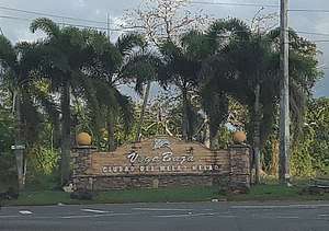
| Nickname(s): "Ciudad del Melao Melao" | |
| Anthem: "Melado Melado" | |
 Location of Vega Baja in Puerto Rico | |
| Coordinates: 18°26′46″N 66°23′15″W | |
| Commonwealth | |
| Founded | October 7, 1776 |
| Government | |
| • Mayor | Marcos Cruz Molina (Partido Popular Democrático) |
| • Senatorial dist. | 3 - Arecibo |
| • Representative dist. | 12 |
| Area | |
| • Total | 55.71 sq mi (144.28 km2) |
| • Land | 47 sq mi (122 km2) |
| • Water | 8.60 sq mi (22.28 km2) |
| Population (2010) | |
| • Total | 59,662 |
| • Density | 1,100/sq mi (410/km2) |
| Demonym(s) | Vegabajeños |
| Time zone | UTC-4 (AST) |
| Zip code | 00693, 00694 |
| Major routes | |
| Website | www |
History
The name Vega Baja in Spanish means lower side of the riverplain. Geographically, the North of Puerto Rico goes down and is slightly higher than the level of the Atlantic Ocean and Vega Baja is a coastal town. Other historians believed that the name Vega Baja comes from La Vega. Vega is a surname of one of the families involved in the foundation of Vega Baja. It is also believed that the name comes from the region of Spain La Vega Baja del Segura.
Although is generally believed that Vega Baja was founded in 1776, after the division of Vega Alta from La Vega, historians have verified that it was many years later when it was officially recognized by the Spanish government. The foundation day is October 7 and it is also the day of commemorating the "Virgin of the Rosary". Vega Baja was originally known as Vega-baxa del Naranjal de Nuestra Señora del Rosario (Vega Baja of the Orange Grove of Our Lady of the Rosary). Orange comes from its previous name based on the fruit that was cultivated in the place.
Cibuco is one of the rivers that goes through Vega Baja, and is a variation of the name "Sebuco", a chief or Cacique Taíno Indian of the region. These "cells" of Taíno Indians were known to settle in the vicinity of the rivers. Although the Cibuco River is prone to floods due to heavy seasonal rains, the benefits provided to the land by the river are numerous.
Taino carvings have been found on some of the exposed reefs in the vicinity of the Cibuco river. Among these carvings is one depicting a face and others shaped as fish. They are an indication that these reefs were frequented for spear fishing and perhaps other day-to-day activities. Other places like Carmelita, Maisabel, Cueva Maldita and Paso del Indio are known as archaeological sites where the aborigines established their communities.
Large amount of cash found
In 1990, over a million dollars in cash was found buried in plastic barrels, thought to have been deposited by drug smugglers for later retrieval. The sudden wealth of a few residents attracted attention and prompted an investigation by FBI and local police.[1]
Hurricane Maria
Hurricane Maria on September 20, 2017 triggered numerous landslides in Vega Baja with the significant amount of rainfall.[2][3]
Geography
.jpg)
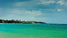
Vega Baja is on the northern coast.[4]
Barrios

Like all municipalities of Puerto Rico, Vega Baja is subdivided into barrios. The municipal buildings, central square and large Catholic church are located in a barrio called "Pueblo" (barrio-pueblo on the US Census).[5][6][7]
Sectors
Barrios (which are like minor civil divisions)[8] in turn are further subdivided into smaller local populated place areas/units called sectores (sectors in English). The types of sectores may vary, from normally sector to urbanización to reparto to barriada to residencial, among others.[9][10][11]
Demographics
The United States took control of Puerto Rico from Spain in the aftermath of the Spanish-American War under the terms of the Treaty of Paris of 1898. In 1899, the United States conducted its first census of Puerto Rico, finding that the population of Vega Baja was 10,305.
| Historical population | |||
|---|---|---|---|
| Census | Pop. | %± | |
| 1900 | 10,305 | — | |
| 1910 | 12,831 | 24.5% | |
| 1920 | 15,756 | 22.8% | |
| 1930 | 20,406 | 29.5% | |
| 1940 | 23,105 | 13.2% | |
| 1950 | 28,925 | 25.2% | |
| 1960 | 30,189 | 4.4% | |
| 1970 | 35,327 | 17.0% | |
| 1980 | 47,115 | 33.4% | |
| 1990 | 55,997 | 18.9% | |
| 2000 | 61,929 | 10.6% | |
| 2010 | 59,662 | −3.7% | |
| U.S. Decennial Census[14] 1899 (shown as 1900)[15] 1910-1930[16] 1930-1950[17] 1960-2000[18] 2010[7] | |||
Tourism
Landmarks and places of interest
There are 14 beaches in Vega Baja.[19] Some main attractions of Vega Baja include:
- Casa Alcaldía
- Casa Alonso Museum
- Casa Portela Museum
- El Trece Recreational Area
- House of Culture and Tourism
- Man of the Sugar Cane Monument
- Melao Melao Artisan Center
- Migrante Square
- Museo del Salon de la Fama del Deporte Vega Baja Melao Melao
- Playa Puerto Nuevo and Recreational Area[20]
- Plaza José Francisco Náter
- Teatro América
- Teatro Fénix
- Tortuguero Lagoon
- Tortuguero Recreational Area
- Trinitarias Park
Economy
The abundant fertility of its soil, has meant Vega Baja has much agricultural and farming land. In addition, Vega Baja has one of the most visited beaches of the northern coastline, Playa de Puerto Nuevo (Playa Mar Bella). This beach attracts thousands of beachgoers annually, making it a center for local tourism, especially during the hot summer months.[20] It boasts a natural rock formation of enormous proportions both in height and length colloquially named La Peña. This rock feature shelters the beach portion from the open seas just behind it. During rough marine conditions, the rock feature protects beachgoers, while the spectacle of waves crashing from behind and cascading down its face can be appreciated in the relative safety of the beach.[21]
Agriculture
- Pineapple, cattle feed (hay). In decades past, the land portion situated between the neighborhood of Monte Carlo and the neighborhood of Los Naranjos, was the site for the cultivation of sugar cane.
Industry
- Clothing, leather articles; electrical and electronic equipment, machinery
- Medical, and pharmaceutical.
Culture
Festivals and events
Melao Melao Marathon - October
Matron Celebrations - October
Christmas Festival - December
"Blue Marlin" Fishing Tournament
Government
Vega Baja, like all municipalities of Puerto Rico, elect a mayor every four years to administer the city. The educator Marcos Cruz Molina is the mayor since 2013 and Ebrahim Narváez is the President of the Municipal Legislature.
The city belongs to the Puerto Rico Senatorial district III, which is represented by two senators. In 2012, José "Joito" Pérez and Ángel "Chayanne" Martínez were elected as District Senators. Rafael (Tatito) Hernández is the Eleventh District Representative and Hector Torres the Twelve District Representative at the House of Representatives of Puerto Rico.
Transportation
There are 23 bridges in Vega Baja.[22]
Symbols
Flag
Vega Baja's flag consists of a yellow cloth crossed by a green band. The band relates to the fertile valley and the river.
Coat of arms
The Vega Baja coat of arms has a v-shaped green band with overlapping roses in silver and three oranges trees, with gold fruit. At the top part is a five-tower crown, silver, black and green. The main colors of the shield; green and gold are used traditionally in civic, scholastic and sports activities. The crown five tower indicates that the town holds the rank of "Villa" by royal decree.
Anthem
The anthem of Vega Baja is "Melado Melado" with lyrics as written in 1974 by Adrián Santos Tirado and music by Roberto Sierra.
Education
Elementary schools
- Agapito Rosario Rosario
- Almirante Sur II
- Almirantito
- Cabo Caribe
- Centro Comunal
- Dr. Jesús M. Armaiz
- Federico Degetau
- Fernando Rosario Vázquez
- José de Diego
- José Gualberto Padilla
- Manuel Negrón Collazo I
- Manuel Padilla Dávila
- Ofelia Díaz
- Rafael Hernández
- Rosa M. Rodríguez
- San Vicente
Middle schools
- Ángel Sandín Martínez
- Brígida Álvarez Rodríguez
- Centro De Adiestramiento
- Segunda Unidad Pugnado Afuera (S.U.P.A) o Segunda Unidad Manuel A. Martínez Dávila
- Segunda Unidad Almirante Norte (S.U.A.N)
High schools
- Lino Padrón Rivera
- Juan Quirindongo Morell
- Brigida Alvarez Rodriguez
Private schools
- Academia Regional Adventista Del Norte
- Colegio Nuestra Señora del Rosario
- Fountain Christian Bilingual School
- North Point Military Academy
- Academia Eden Montesory
- Christian Military
- Academia El Arca Centro Educativo
- Believer's Academy
- Mech Tech
See also
- List of Puerto Ricans
- History of Puerto Rico
- Did you know-Puerto Rico?
References
- Lemoyne, James (April 18, 1990). "Talk of a Puerto Rico Town: Buried Treasure, No Kidding". NYT. Archived from the original on August 15, 2017. Retrieved February 24, 2019.
- "Preliminary Locations of Landslide Impacts from Hurricane Maria, Puerto Rico". USGS Landslide Hazards Program. USGS. Archived from the original on 2019-03-03. Retrieved 2019-03-03.
- "Preliminary Locations of Landslide Impacts from Hurricane Maria, Puerto Rico" (PDF). USGS Landslide Hazards Program. USGS. Archived (PDF) from the original on 2019-03-03. Retrieved 2019-03-03.
- "Vega Baja Municipality". enciclopediapr.org. Fundación Puertorriqueña de las Humanidades (FPH). Archived from the original on 2019-05-09. Retrieved 2019-03-20.
- Picó, Rafael; Buitrago de Santiago, Zayda; Berrios, Hector H. Nueva geografía de Puerto Rico: física, económica, y social, por Rafael Picó. Con la colaboración de Zayda Buitrago de Santiago y Héctor H. Berrios. San Juan Editorial Universitaria, Universidad de Puerto Rico,1969. Archived from the original on 2018-12-26. Retrieved 2018-12-30.
- Gwillim Law (20 May 2015). Administrative Subdivisions of Countries: A Comprehensive World Reference, 1900 through 1998. McFarland. p. 300. ISBN 978-1-4766-0447-3. Retrieved 25 December 2018.
- Puerto Rico:2010:population and housing unit counts.pdf (PDF). U.S. Dept. of Commerce Economics and Statistics Administration U.S. Census Bureau. 2010. Archived (PDF) from the original on 2017-02-20. Retrieved 2018-12-30.
- "US Census Barrio-Pueblo definition". factfinder.com. US Census. Archived from the original on 13 May 2017. Retrieved 5 January 2019.
- "Agencia: Oficina del Coordinador General para el Financiamiento Socioeconómico y la Autogestión (Proposed 2016 Budget)". Puerto Rico Budgets (in Spanish). Retrieved 28 June 2019.
- Rivera Quintero, Marcia (2014), El vuelo de la esperanza: Proyecto de las Comunidades Especiales Puerto Rico, 1997-2004 (first ed.), San Juan, Puerto Rico Fundación Sila M. Calderón, ISBN 978-0-9820806-1-0
- "Leyes del 2001". Lex Juris Puerto Rico (in Spanish). Retrieved 24 June 2020.
- Rivera Quintero, Marcia (2014), El vuelo de la esperanza:Proyecto de las Comunidades Especiales Puerto Rico, 1997-2004 (Primera edición ed.), San Juan, Puerto Rico Fundación Sila M. Calderón, p. 273, ISBN 978-0-9820806-1-0
- "Comunidades Especiales de Puerto Rico" (in Spanish). 8 August 2011. Archived from the original on 24 June 2019. Retrieved 24 June 2019.
- "U.S. Decennial Census". United States Census Bureau. Archived from the original on February 13, 2020. Retrieved September 21, 2017.
- "Report of the Census of Porto Rico 1899". War Department Office Director Census of Porto Rico. Archived from the original on July 16, 2017. Retrieved September 21, 2017.
- "Table 3-Population of Municipalities: 1930 1920 and 1910" (PDF). United States Census Bureau. Archived (PDF) from the original on August 17, 2017. Retrieved September 21, 2017.
- "Table 4-Area and Population of Municipalities Urban and Rural: 1930 to 1950" (PDF). United States Census Bureau. Archived (PDF) from the original on August 30, 2015. Retrieved September 21, 2014.
- "Table 2 Population and Housing Units: 1960 to 2000" (PDF). United States Census Bureau. Archived (PDF) from the original on July 24, 2017. Retrieved September 21, 2017.
- "Las 1,200 playas de Puerto Rico [The 1200 beaches of Puerto Rico]". Primera Hora (in Spanish). April 14, 2017. Archived from the original on December 12, 2019. Retrieved December 12, 2019.
- "Vega Baja busca una Alianza Público Privada para la casona del balneario". El Nuevo Dia (in Spanish). 22 February 2019. Archived from the original on 23 February 2019. Retrieved 15 March 2019.
- "¿Te bañarías en esta playa con un rompeolas natural que parece un tsunami? (VIDEO)". Diario Correo. January 6, 2018. Archived from the original on October 22, 2019. Retrieved October 22, 2019.
- "Vega Baja Bridges". National Bridge Inventory Data. US Dept. of Transportation. Archived from the original on 21 February 2019. Retrieved 20 February 2019.
External links
- Enciclopedia Vegabajena
- Official Municipal Government Website
- Archivo del Diario Vegabajeño de Puerto Rico Segunda Etapa de Diciembre 2012 a Octubre 2016
- (sin título)
- U.S. Census Bureau QuickFacts: Vega Baja Municipio, Puerto Rico
- Vega Baja Municipality on Facebook