Las Marías, Puerto Rico
Las Marías (Spanish pronunciation: [las maˈrias]) is a municipality of Puerto Rico located north of Maricao; southeast of Añasco; south of San Sebastián; east of Mayagüez; and west of Lares. Las Marías is spread over 13 barrios and Las Marías Pueblo (the downtown area and the administrative center of the city).
Las Marías Municipio de Las Marías | |
|---|---|
Town and Municipality | |
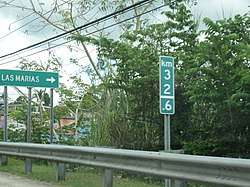 Sign for Las Marías on Puerto Rico Highway 129 | |
 Flag | |
| Nicknames: "Pueblo de la China Dulce", "Ciudad de los Cítricos" | |
| Anthem: "Por tus montes y tus aguas cristalinas" | |
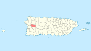 Location of Las Marías in Puerto Rico | |
| Coordinates: 18°15′5″N 66°59′36″W | |
| Commonwealth | |
| Founded | 1871 |
| Government | |
| • Mayor | Edwin Soto Santiago (NPP) |
| • Senatorial dist. | 4 - Mayagüez |
| • Representative dist. | 16 |
| Area | |
| • Total | 46.51 sq mi (120.5 km2) |
| • Land | 46.36 sq mi (120.1 km2) |
| • Water | .11 sq mi (0.3 km2) |
| Population (2010) | |
| • Total | 9,881 |
| • Density | 210/sq mi (82/km2) |
| Demonym(s) | Marieños |
| Time zone | UTC−4 (AST) |
| Zip code | 00670 |
| Major routes | |
History
Las Marías was founded in July 1, 1872. Don Benito Recio and Moreno were the acting mayor during the founding of Las Marías.
When after the Treaty of Paris of 1898, the U.S. conducted its first census of Puerto Rico, the population of Las Marías was 11,279.[1]
Geography
Las Marías is located on the central western side of Puerto Rico. According to the 2010 U.S. Census Bureau, the municipality has a total area of 46.51 square miles (120.5 km2), of which 46.36 square miles (120.1 km2) is land and 0.11 square mile (0.28 km2) is water.[4]
Río Grande de Añasco (also known as Río Guacio) is located in Las Marías.
Barrios
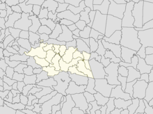
Like all municipalities of Puerto Rico, Las Marías is subdivided into barrios. The municipal buildings, central square and large Catholic church are located near the center of the municipality, in a small barrio referred to as "el pueblo".[5][6][7][8]
Sectors
Barrios (which are like minor civil divisions)[9] in turn are further subdivided into smaller local populated place areas/units called sectores (sectors in English). The types of sectores may vary, from normally sector to urbanización to reparto to barriada to residencial, among others.[10][11][12]
Special Communities
Of the 742 places on the list of Comunidades Especiales de Puerto Rico, the following 7 sectors were in Adjuntas: Sector La Josefa in Bucarabones, Sector Bryan in Cerróte, Sector Chamorro in Cerróte, Sector Palo Prieto in Palma Escrita, Sector Plato Indio in Río Cañas, Las Juanitas in Furnias, and Sector Santa Rosa in Furnias.[13][14]
Demographics
| Historical population | |||
|---|---|---|---|
| Census | Pop. | %± | |
| 1900 | 11,279 | — | |
| 1910 | 10,046 | −10.9% | |
| 1920 | 10,736 | 6.9% | |
| 1930 | 8,881 | −17.3% | |
| 1940 | 9,626 | 8.4% | |
| 1950 | 10,807 | 12.3% | |
| 1960 | 9,237 | −14.5% | |
| 1970 | 7,841 | −15.1% | |
| 1980 | 8,747 | 11.6% | |
| 1990 | 9,306 | 6.4% | |
| 2000 | 11,061 | 18.9% | |
| 2010 | 9,881 | −10.7% | |
| U.S. Decennial Census[15] 1899 (shown as 1900)[16] 1910-1930[17] 1930-1950[18] 1960-2000[19] 2010[7] | |||
Tourism
Paradise Camping Coffee Farm is a place for ecotourism and camping in Las Marías.[20]
Landmarks and places of interest
- Barrietos Cavern
- Fronteras Hacienda
- Planell Hacienda
- Rullán Hacienda
- San Calisto Hacienda
- San Carlos Plaza
- Paco Gaztambide Sugar Mill Ruins
- Las Canadindias
Economy
Agriculture
- Agriculture: bananas, coffee, and citrus.
Industry
- Manufacturing: clothing.
Culture
Festivals and events
- January - Three King's Festival
- March - Orange Festival (Festival de las Chinas). At the 2019 festival, a big name band, El Gran Combo performed at the festival, and a group of trobadours from Cuba performed with local Puerto Rican trobadours.[21]
- March - Festival to commemorate the founding of Las Marías (Festival de Las Marías)[21]
- December - Matron Festivities
Government
Like all municipalities in Puerto Rico, Las Marías is administered by a mayor. The current mayor is Edwin Soto Santiago, from the New Progressive Party (PNP). Soto Santiago was elected during the 2016 general election, having previously served office from 1997 to 2013.
The municipality belongs to the Puerto Rico Senatorial District IV, which is represented by two Senators. In 2016, Luis Daniel Muñiz Cortés and Evelyn Vázquez were elected as District Senators.[22]
Transportation
There are 13 bridges in Las Marías.[23]
Symbols
Flag
The flag is divided by an imaginary diagonal line whose ends are the superior left angle of the flag and the opposite lower angle. The superior part is yellow and the lower half is green. The yellow portion represents the sun bathing the town and the green portion represents the nature and vegetation of the municipality.[4]
Coat of arms
The shield is divided into six parts with three in silver and three in blue. A "María" tree (Callophylum brasiliense antillum), with a pair of coffee tree branches to the sides of its trunk, adorns each silver part. The monogram and crown of Nuestra Señora la Santísima Virgen de Plata is placed in the top center portion of the shield. The shield's border is red with a broken chain at the bottom. Above the shield resides three tower crown in gold.[4]
See also
- List of Puerto Ricans
- History of Puerto Rico
- Did you know-Puerto Rico?
References
- Joseph Prentiss Sanger; Henry Gannett; Walter Francis Willcox (1900). Informe sobre el censo de Puerto Rico, 1899, United States. War Dept. Porto Rico Census Office (in Spanish). Imprenta del gobierno. p. 164.
- "Preliminary Locations of Landslide Impacts from Hurricane Maria, Puerto Rico". USGS Landslide Hazards Program. USGS. Archived from the original on 2019-03-03. Retrieved 2019-03-03.
- "Preliminary Locations of Landslide Impacts from Hurricane Maria, Puerto Rico" (PDF). USGS Landslide Hazards Program. USGS. Archived (PDF) from the original on 2019-03-03. Retrieved 2019-03-03.
- "Las Marías Municipality". enciclopediapr.org. Fundación Puertorriqueña de las Humanidades (FPH).
- Picó, Rafael; Buitrago de Santiago, Zayda; Berrios, Hector H. Nueva geografía de Puerto Rico: física, económica, y social, por Rafael Picó. Con la colaboración de Zayda Buitrago de Santiago y Héctor H. Berrios. San Juan Editorial Universitaria, Universidad de Puerto Rico,1969. Archived from the original on 2018-12-26. Retrieved 2018-12-28.
- Gwillim Law (20 May 2015). Administrative Subdivisions of Countries: A Comprehensive World Reference, 1900 through 1998. McFarland. p. 300. ISBN 978-1-4766-0447-3. Retrieved 25 December 2018.
- Puerto Rico:2010:population and housing unit counts.pdf (PDF). U.S. Dept. of Commerce Economics and Statistics Administration U.S. Census Bureau. 2010. Archived (PDF) from the original on 2017-02-20. Retrieved 2018-12-28.
- "Map of Las Marías at the Wayback Machine" (PDF). Archived from the original (PDF) on 2018-03-24. Retrieved 2018-12-29.
- "US Census Barrio-Pueblo definition". factfinder.com. US Census. Archived from the original on 13 May 2017. Retrieved 5 January 2019.
- "Agencia: Oficina del Coordinador General para el Financiamiento Socioeconómico y la Autogestión (Proposed 2016 Budget)". Puerto Rico Budgets (in Spanish). Retrieved 28 June 2019.
- Rivera Quintero, Marcia (2014), El vuelo de la esperanza: Proyecto de las Comunidades Especiales Puerto Rico, 1997-2004 (first ed.), San Juan, Puerto Rico Fundación Sila M. Calderón, ISBN 978-0-9820806-1-0
- "Leyes del 2001". Lex Juris Puerto Rico (in Spanish). Retrieved 24 June 2020.
- Rivera Quintero, Marcia (2014), El vuelo de la esperanza: Proyecto de las Comunidades Especiales Puerto Rico, 1997-2004 (1st ed.), San Juan, Puerto Rico Fundación Sila M. Calderón, p. 273, ISBN 978-0-9820806-1-0
- "Comunidades Especiales de Puerto Rico" (in Spanish). 8 August 2011. Archived from the original on 24 June 2019. Retrieved 24 June 2019.
- "U.S. Decennial Census". United States Census Bureau. Archived from the original on February 13, 2020. Retrieved September 21, 2017.
- "Report of the Census of Porto Rico 1899". War Department Office Director Census of Porto Rico. Archived from the original on July 16, 2017. Retrieved September 21, 2017.
- "Table 3-Population of Municipalities: 1930 1920 and 1910" (PDF). United States Census Bureau. Archived (PDF) from the original on August 17, 2017. Retrieved September 21, 2017.
- "Table 4-Area and Population of Municipalities Urban and Rural: 1930 to 1950" (PDF). United States Census Bureau. Archived (PDF) from the original on August 30, 2015. Retrieved September 21, 2014.
- "Table 2 Population and Housing Units: 1960 to 2000" (PDF). United States Census Bureau. Archived (PDF) from the original on July 24, 2017. Retrieved September 21, 2017.
- "Archived copy". Archived from the original on 2019-07-11. Retrieved 2019-07-06.CS1 maint: archived copy as title (link)
- Rí, Melissa Cruz; Vocero, El (16 March 2019). "Descubre Las Marías el pueblo de la china". El Vocero de Puerto Rico (in Spanish). Archived from the original on 17 August 2019. Retrieved 17 August 2019.
- Elecciones Generales 2012: Escrutinio General Archived 2013-01-15 at the Wayback Machine on CEEPUR
- "Las Marías Bridges". National Bridge Inventory Data. US Dept. of Transportation. Archived from the original on 21 February 2019. Retrieved 20 February 2019.