Humacao, Puerto Rico
Humacao (Spanish pronunciation: [umaˈka.o]) is a municipality in Puerto Rico located in the eastern coast of the island, north of Yabucoa; south of Naguabo; east of Las Piedras; and west of Vieques Passage. Humacao is spread over 10 wards and Humacao Pueblo (the downtown area and the administrative center of the city). It is part of the San Juan-Caguas-Guaynabo Metropolitan Statistical Area.
Humacao Municipio Autónomo de Humacao | |
|---|---|
Municipality | |
 Downtown Humacao from its city hall | |
 Flag 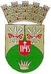 Coat of arms | |
| Nicknames: "La Perla del Oriente", "La Cuidad Gris", "Roye Huesos" | |
| Anthem: "Humacao, Hijo del Taíno Bravío" | |
 Location of Humacao in Puerto Rico | |
| Coordinates: 18°08′59″N 65°49′39″W | |
| Commonwealth | |
| Founded | April 1722 |
| Government | |
| • Mayor | Luis Raul Sanchez[1] (Partido Popular Democrático) |
| • Senatorial dist. | 7 - Humacao |
| • Representative dist. | 35 |
| Area | |
| • Total | 55.46 sq mi (143.63 km2) |
| • Land | 45 sq mi (117 km2) |
| • Water | 10.28 sq mi (26.63 km2) |
| Population (2010) | |
| • Total | 58,466 |
| • Density | 1,100/sq mi (410/km2) |
| • Racial groups (2000 Census) [2] | 69.7% White 12.9% Black 0.4% American Indian/An 0.3% Asian 0.0% Native Hawaiian/Pi 9.7% Some other race 6.9% Two or more races |
| Demonym(s) | Humacaeños |
| Time zone | UTC-4 (AST) |
| Zip code | 00791, 00792, 00741 |
| Major routes | |
History
.jpg)
The region of what is now Humacao belonged to the Taíno region of Jumaca, which covered a portion of the southeast coast of Puerto Rico.[3] The region was led by cacique Jumacao (also referred to as "Macao").[4] The Taíno settlement was located on the shores of what is called now the Humacao River. It is believed that the Taíno chief Jumacao was the first "cacique" to learn to read and write in Spanish, since he wrote a letter to the King of Spain Charles I complaining about how the Governor of the island wasn't complying with their peace agreement. In the letter, Jumacao argued that their people were virtually prisoners of Spain. It is said that King Charles was so moved by the letter that he ordered the Governor to obey the terms of the treaty.[5][6]
During the early 16th Century, the region was populated by cattle ranchers. However, since most of them officially resided in San Juan, a settlement was never officially organized. At the beginning of the 18th Century, specifically around 1721–1722, the first official settlement was constituted in the area. Most of the residents at the time were immigrants from the Canary Islands, but due to attacks from Caribs, pirates, and other settlers, some of them moved farther into the island in what is now Las Piedras.[7] Still, some settlers remained and by 1776, historian Fray Íñigo Abbad y Lasierra visited the area and wrote about the population there. By 1793, the church was recognized as parish and the settlement was officially recognized as town.[5]
By 1894, Humacao was recognized as a city. Due to its thriving population, buildings and structures like a hospital, a theater, and a prison were built in the city. In 1899, after the United States invasion of the island as a result of the Spanish–American War, the town of Las Piedras was annexed to Humacao. This lasted until 1914, when the Legislative Assembly of Puerto Rico voted on splitting both towns again.[7]
Humacao was led by mayor Marcelo Trujillo Panisse for over a decade. A basketball star in his early years, Trujillo has pushed for the development of infrastructure facilities for sports and the fine arts in the city. On March, 2008, a new Roman Catholic diocese was established as the Fajardo-Humacao diocese. Its first bishop is Monsignor Eusebio 'Chebito' Ramos Morales, a maunabeño who was rector of the Humacao's main parish in the 1990s.
In 2019, Luis Raul Sanchez became interim mayor of Humacao after Marcelo Trujillo Panisse passed in September 2019.[1]
Geography
Humacao is located in the southeast coast of Puerto Rico. It is bordered by the municipalities of Naguabo to the north, Yabucoa to the south, and Las Piedras to the west. The Atlantic Ocean borders the city in the east. Humacao is located in the region of the Eastern Coastal Plains, with most of its territory being flat. There are minor elevations to the southwest, like Candelero Hill, and northwest, like Mabú. Humacao's territory covers 45 square miles (117 km2).[5] Two islands belong to Humacao: Cayo Santiago and Cayo Batata.[8]
Water features
Humacao's hydrographic system consists of many rivers and creeks like Humacao, Antón Ruíz, and Candelero. Some of its creeks are Frontera, Mariana, and Del Obispo, among many others.[5]
In 2019, updated flood zone maps show that Humacao is extremely vulnerable to flooding, along with Toa Baja, Rincón, Barceloneta, and Corozal. Located where most cyclones enter the island, Humacao is one of the most vulnerable areas of Puerto Rico.[9] Humacao was working on flood mitigation plans and shared that its barrios located on the coast; Antón Ruíz, Punta Santiago, Río Abajo, Buena Vista and Candelero Abajo barrios, are extremely vulnerable to flooding and destruction.[10]
Barrios

Like all municipalities of Puerto Rico, Humacao is subdivided into barrios. The municipal buildings, central square and large Catholic church are located in a small barrio referred to as "el pueblo", near the center of the municipality.[11][12][13][14]
Sectors
Barrios (which are like minor civil divisions)[15] in turn are further subdivided into smaller local populated place areas/units called sectores (sectors in English). The types of sectores may vary, from normally sector to urbanización to reparto to barriada to residencial, among others.[16][17][18]
Special Communities
Of the 742 places on the list of Comunidades Especiales de Puerto Rico, the following barrios, communities, sectors, or neighborhoods are in Humacao: Antón Ruiz, Obrera neighborhood, Cotto Mabú-Fermina, Buena Vista, Parcelas Aniseto Cruz in Candelero Abajo, Parcelas Martínez in Candelero Abajo, Cataño, Punta Santiago, Verde Mar, and Cangrejos.[19][20]
Demographics
The United States took control of Puerto Rico from Spain in the aftermath of the Spanish-American War under the terms of the Treaty of Paris of 1898 and conducted its first census of Puerto Rico, finding that the population of Humacao was 14,313.
| Historical population | |||
|---|---|---|---|
| Census | Pop. | %± | |
| 1900 | 14,313 | — | |
| 1910 | 26,678 | 86.4% | |
| 1920 | 20,229 | −24.2% | |
| 1930 | 25,466 | 25.9% | |
| 1940 | 29,833 | 17.1% | |
| 1950 | 34,853 | 16.8% | |
| 1960 | 33,381 | −4.2% | |
| 1970 | 36,023 | 7.9% | |
| 1980 | 46,134 | 28.1% | |
| 1990 | 55,203 | 19.7% | |
| 2000 | 59,035 | 6.9% | |
| 2010 | 58,466 | −1.0% | |
| U.S. Decennial Census[21] 1899 (shown as 1900)[22] 1910-1930[23] 1930-1950[24] 1960-2000[25] 2010[13] | |||
Tourism

There are 8 beaches in Humacao including Punta Santiago.[26]
Due to its location on the coast and relative short distance from the capital, Humacao is a frequent stop for tourists. One of the most notable tourist mainstays is the Palmas del Mar resort, which is the island's largest resort. This megaresort is composed of over 3,000 acres (12 km2) of land and occupies the entire south eastern portion of the municipal territory. The resort contains over 20 tennis courts, two world-class golf courses, beaches, several restaurants and a riding center.
Aside from the beaches at the Palmas del Mar resort, Humacao has other beaches. The most popular ones are Punta Santiago, Buena Vista, Punta Candelero, and El Morrillo.[7]
The Candelero Beach Resort, built in 1973, with its 107 rooms, 25 which are suites, was purchased and revitalized by the Suarez family.[27]
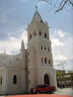
Other landmarks found in Humacao are the Astronomical Observatory in the University of Puerto Rico at Humacao,[28] Casa Roig, the Guzmán Ermit, the Wildlife Refuge, and the Church Dulce Nombre de Jesús.
In the 1980s, the Puerto Rico Department of Natural and Environmental Resources established the Punta Santiago Nature Reserve in the municipality.[29]
Economy
Burlington store in Humacao employs under 100 people and reopened its doors in March 2019. The store had been shuttered since Hurricane Maria destroyed it on September 19, 2017.[30]
Culture
Festivals and events
The Fiesta patronal dedicated to the Immaculate Conception is held at the beginning of December. It has lost most of its religious content to become a festival of live music, food, drinks and verbenas.
The Breadfruit Festival (Festival de la Pana) is celebrated during the first weekend of September. It is organized by the Mariana's Recreational and Cultural Association (ARECMA), a community organization of the Barrio Mariana. Its main theme is about the preparation of dishes whose main ingredient is breadfruit. Typical Puerto Rican music, crafts and foods as well as other cultural and sports activities can also be enjoyed. Most years it has been held at one of the highest places of the sector with views to Humacao, Las Piedras, Naguabo, Vieques and Yabucoa.
Humacao Grita is an urban art festival held in November.[31]
Sports
The Grises basketball team (Humacao Grays), founded in 2005, belongs to Puerto Rico's National Superior Basketball league. In 2010, they changed their name to the Caciques de Humacao. They play at the new Humacao Coliseum.
The Grises is also a Double A class amateur baseball team that has won one championship (1951) and four time runners-up in (1950, 1960, 1965 and 1967).
Government
Like all municipalities in Puerto Rico, Humacao is administered by a mayor. The current major, Luis Raul Sanchez, got into office, after Marcelo Truijillo Panisse passed in September 2019.[1] The former mayor was Marcelo Trujillo, from the Popular Democratic Party (PPD) was elected at the 2000 general election and served for many years.
The city belongs to the Puerto Rico Senatorial district VII, which is represented by two Senators. In 2012, Jorge Suárez and José Luis Dalmau were elected as District Senators.[32]
Healthcare
Humacao has three secondary care hospitals HIMA-San Pablo Humacao, Dr. Domínguez (Hospital Oriente), and Ryder Memorial Hospital.
Symbols
Flag
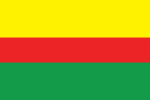
It consists of three horizontal stripes: gold that stands for Chief Jumacao's crown, red that symbolizes the coat of arms and the green that represents the arrows used by the Taínos.
Coat of arms
The coat of arms consists of two colors, gold and green. The gold represents the sun, Humacao is located in the island were the sun rises. Green symbolizes the native Indian heritage as well as the natural tropical valley where the city is located. The shield itself represents Humacao's native and Indian name origin.
Transportation
Humacao's airport is no longer used for daily flights to Vieques and Culebra as it was in the past. It is now used for private flights.
Humacao is served by two freeways and one tolled expressway, therefore is one of a few cities in Puerto Rico with good access. Puerto Rico Highway 30, Autopista Cruz Ortiz Stella, serves as the main highway coming from the west (Caguas, Las Piedras), while Puerto Rico Highway 53 serves from the north (Fajardo, Naguabo) and south (Yabucoa). Puerto Rico Highway 60, the Carretera Dionisio Casillas, is a short freeway located entirely in Humacao, and has exits serving downtown Humacao and Anton Ruiz.
Puerto Rico Highway 3, the main highway bordering the east coastline of Puerto Rico from San Juan, passes through Humacao and has its only alt route in the town, known locally as the Bulevar del Rio (River Boulevard) where it has access to the main judiciary center of the city, as well as a future theatre that is being built, the Centro de Bellas Artes de Humacao (Humacao Fine Arts Center). The alt route allows people to pass by the downtown area, as PR-3 enters into the downtown and business center of the town.
Puerto Rico Highway 908 is another important highway, which begins at PR-3 and intersects PR-30 and has access to the University of Puerto Rico at Humacao, as well as some main schools.
Humacao, together with San Juan and Salinas, is one of three municipalities in Puerto Rico that has controlled-access highways leaving its boundaries in all directions (in this case north to Naguabo and south to Yabucoa via PR-53 and west to Las Piedras via PR-30)
There are 68 bridges in Humacao.[34]
Education
There are various elementary and high school facilities, three of which were recognized by the Middle States Association of Secondary Schools and each has its own National Honor Society chapters.
The University of Puerto Rico at Humacao, formerly the CUH, educates over 4,000 students and is well known for its sciences, producing many of the island's most skilled microbiologists, marine biologists, wildlife biologists and chemists at the undergraduate level. It also manages an astronomical observatory where many tourists and locals come visit and view the stars and planets and the Museo Casa Roig where arts expositions and cultural events are celebrated.
Notable natives and residents
- Rita Moreno, Academy Award-winning actress
- Edwin Núñez, Professional Baseball player
- Luis Rafael Sánchez, novelist and author
- Rossana Rodriguez-Sanchez, member of the Chicago City Council
- Eddie Miró, TV personality
- Julio M. Fuentes, US Circuit Court Judge
- Tito Rojas, Salsa singer
- Adamari López, actress
- Jaquira Díaz, author, journalist
- Cosculluela, rapper, songwriter
- Eladio Carrión, rapper, songwriter
- Jumacao, Taino Cacique
- Benito Pastoriza Iyodo, poet, narrator, and essayist
- Carlos Ponce, actor
- Luis Antonio "Yoyo Boing" Rivera, actor and comedian
- Jerry Rivera, singer and dancer
- Junior Ortiz, former Major League Baseball player
- Raul Casanova, former Major League Baseball player
- Rafael Orellano, former professional baseball player
- Jantony Ortiz, Professional Boxer
- José Estrada Jr., Former professional wrestler
- Ana Otero, Pianist, composer, arranger, conductor, activist.[35]
Gallery
 A beach in Humacao
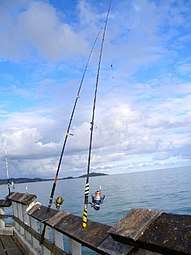 Fishing from a pier in Humacao
See also
- List of Puerto Ricans
- History of Puerto Rico
- Did you know-Puerto Rico?
References
- "Confirmadas las aspiraciones políticas de Luis Raúl Sánchez - Periódico El Oriental". Archived from the original on 2019-06-08. Retrieved 2019-09-16.
- "Ethnicity 2000 census" (PDF). Archived (PDF) from the original on 2008-02-16. Retrieved 2008-04-30.
- "Gobierno Tribal del Pueblo Jatibonicu Taíno de Puerto Rico". Archived from the original on January 22, 2014. Retrieved March 30, 2014.
- Schimmer, Russell (2010). "Genocide Studies Program: Puerto Rico". Yale University. Archived from the original on May 20, 2013. Retrieved April 13, 2014.
- "Humacao... la Perla del Oriente". ProyectoSalonHogar. Archived from the original on July 13, 2014. Retrieved April 13, 2014.
- "El agua del paraíso (Spanish Edition)"; by: Benito Pastoriza Iyodo; Publisher: Xlibris (April 21, 2008); ISBN 1-4363-2567-6; ISBN 978-1-4363-2567-7
- "Enciclopedia de Puerto Rico: Humacao - Fundación e historia". Archived from the original on April 14, 2014. Retrieved April 14, 2014.
- "Humacao Municipality". enciclopediapr.org. Fundación Puertorriqueña de las Humanidades (FPH). Archived from the original on 2019-05-02. Retrieved 2019-03-20.
- Alvarado León, Gerardo E. "Sobre 250,000 estructuras están en zonas inundables" (PDF). Junta de Planificación - Gobierno de Puerto Rico (in Spanish). El Nuevo Día. Archived (PDF) from the original on 13 June 2019. Retrieved 3 July 2019.
- Solano Quintana, Bárbara. "Piden participación ciudadana para revisión del plan de mitigación de Humacao" (PDF). El Nuevo Día (in Spanish). Archived (PDF) from the original on 13 June 2019. Retrieved 3 July 2019 – via Junta de Planificación Gobierno de Puerto Rico.
- Picó, Rafael; Buitrago de Santiago, Zayda; Berrios, Hector H. Nueva geografía de Puerto Rico: física, económica, y social, por Rafael Picó. Con la colaboración de Zayda Buitrago de Santiago y Héctor H. Berrios. San Juan Editorial Universitaria, Universidad de Puerto Rico,1969. Archived from the original on 2018-12-26. Retrieved 2018-12-29.
- Gwillim Law (20 May 2015). Administrative Subdivisions of Countries: A Comprehensive World Reference, 1900 through 1998. McFarland. p. 300. ISBN 978-1-4766-0447-3. Retrieved 25 December 2018.
- Puerto Rico:2010:population and housing unit counts.pdf (PDF). U.S. Dept. of Commerce Economics and Statistics Administration U.S. Census Bureau. 2010. Archived (PDF) from the original on 2017-02-20. Retrieved 2018-12-29.
- "Map of Humacao at the Wayback Machine" (PDF). Archived from the original (PDF) on 2018-03-24. Retrieved 2018-12-29.
- "US Census Barrio-Pueblo definition". factfinder.com. US Census. Archived from the original on 13 May 2017. Retrieved 5 January 2019.
- "Agencia: Oficina del Coordinador General para el Financiamiento Socioeconómico y la Autogestión (Proposed 2016 Budget)". Puerto Rico Budgets (in Spanish). Retrieved 28 June 2019.
- Rivera Quintero, Marcia (2014), El vuelo de la esperanza: Proyecto de las Comunidades Especiales Puerto Rico, 1997-2004 (first ed.), San Juan, Puerto Rico Fundación Sila M. Calderón, ISBN 978-0-9820806-1-0
- "Leyes del 2001". Lex Juris Puerto Rico (in Spanish). Retrieved 24 June 2020.
- Rivera Quintero, Marcia (2014), El vuelo de la esperanza:Proyecto de las Comunidades Especiales Puerto Rico, 1997-2004 (Primera edición ed.), San Juan, Puerto Rico Fundación Sila M. Calderón, p. 273, ISBN 978-0-9820806-1-0
- "Comunidades Especiales de Puerto Rico" (in Spanish). 8 August 2011. Archived from the original on 24 June 2019. Retrieved 24 June 2019.
- "U.S. Decennial Census". United States Census Bureau. Archived from the original on February 13, 2020. Retrieved September 21, 2017.
- "Report of the Census of Porto Rico 1899". War Department Office Director Census of Porto Rico. Archived from the original on July 16, 2017. Retrieved September 21, 2017.
- "Table 3-Population of Municipalities: 1930 1920 and 1910" (PDF). United States Census Bureau. Archived (PDF) from the original on August 17, 2017. Retrieved September 21, 2017.
- "Table 4-Area and Population of Municipalities Urban and Rural: 1930 to 1950" (PDF). United States Census Bureau. Archived (PDF) from the original on August 30, 2015. Retrieved September 21, 2014.
- "Table 2 Population and Housing Units: 1960 to 2000" (PDF). United States Census Bureau. Archived (PDF) from the original on July 24, 2017. Retrieved September 21, 2017.
- "Las 1,200 playas de Puerto Rico [The 1200 beaches of Puerto Rico]". Primera Hora (in Spanish). April 14, 2017. Archived from the original on December 12, 2019. Retrieved December 12, 2019.
- "Revitalizan el Candelero Beach Resort en Humacao". El Nuevo Dia (in Spanish). 6 December 2018. Archived from the original on 4 September 2019. Retrieved 4 September 2019.
- "Observatorio Astronómico". Universidad de Puerto Rico en Humacao. Archived from the original on June 29, 2014. Retrieved April 15, 2014.
- Fotogalería: Paseo por la Reserva Natural de Humacao. Jose E. Maldonado. Mi Puerto Rico Verde. 19 September 2012. Accessed 2 March 2020.
- "Se acabó la espera: reabre sus puertas Burlington en Humacao" (in Spanish). El Oriental PR. 15 March 2019.
- ""Humacao Grita" Festival de arte urbano este domingo". El Foro de Puerto Rico (in Spanish). 14 November 2019. Retrieved 20 June 2020.
- Elecciones Generales 2012: Escrutinio General Archived 2013-01-15 at the Wayback Machine on CEEPUR
- "San Juan — FBI". Archived from the original on 2019-07-03. Retrieved 2019-06-23.
- "Humacao Bridges". National Bridge Inventory Data. US Dept. of Transportation. Archived from the original on 20 February 2019. Retrieved 19 February 2019.
- "Ana Otero Hernandez bio]" (in Spanish). San Juan, Puerto Rico: National Foundation for Popular Culture. Archived from the original on 2019-10-19. Retrieved 2019-10-28.