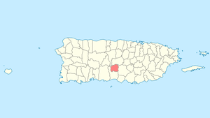
Villalba, Puerto Rico
Villalba (Spanish pronunciation: [biˈʎalβa]) (a shortening of Villa Alba) is a municipality of Puerto Rico located in the central region, northeast of Juana Díaz; south of Orocovis; and west of Coamo. Villalba is spread over 6 wards and Villalba Pueblo (the downtown area and the administrative center of the city). It is part of the Ponce Metropolitan Statistical Area.
Villalba Municipio de Villalba | |
|---|---|
Town and Municipality | |
 | |
 Flag | |
| Nicknames: "Ciudad de los Avancinos", "Ciudad del Gandul", "Ciudad de los Lagos", "Ciudad del Cooperativismo" | |
| Anthem: "A las orillas del Río Jacaguas" | |
 Location of Villalba in Puerto Rico | |
| Coordinates: 18°07′38″N 66°29′32″W | |
| Commonwealth | |
| Founded | 1917 |
| Government | |
| • Mayor | Luis Javier 'Javi' Hernández Ortiz (PPD) |
| • Senatorial dist. | 6 - Guayama |
| Area | |
| • Total | 37.69 sq mi (97.61 km2) |
| • Land | 37 sq mi (96 km2) |
| • Water | 0.62 sq mi (1.61 km2) |
| Population (2010) | |
| • Total | 26,073 |
| • Density | 690/sq mi (270/km2) |
| Demonym(s) | Villalbeños |
| Time zone | UTC−4 (AST) |
| Zip code | 00766 |
| Major routes | |
History
Villalba was founded in 1917 by José Ramón Figueroa y Rivera and Walter McJones. Its current mayor is the Luis Javier Hernàndez.
Hurricane Maria

Hurricane Maria on September 20, 2017 triggered numerous landslides in Villalba with the significant amount of rainfall.[1][2]
The entire electrical system was destroyed. Villalba's emergency operations center and an assisted living center were among the many buildings destroyed in Villalba.[3] "From Catastrophe to Hope" (De la catastrofe a la esperanza), a documentary describing the destruction of infrastructure in Villalba, and how volunteers, community members, the mayor, and all emergency service personnel worked to save people's lives, was published in 2019 by Noticias de Villalba, Villalba News. Bridges were destroyed and many areas where vital infrastructure was located were inaccessible. The geography of Villalba made restoring electricity and water services to Villalba extremely challenging. Chaplains, religious leaders of all denominations provided emotional support to all involved.[4]
In 2018, Javier Hernández, the mayor discussed other options for electrical power, such as micro-grids, for Villalba, with the mayor of Hoboken, New Jersey, who reminded him that recovery from such a powerful hurricane would take years.[5][6] Architect Jonathan Marvel talked about his company's plans to build an off-the-grid, 41-unit building in Villalba on the one-year anniversary of Hurricane Maria.[7]
Geography
Villalba is located in the central region of Puerto Rico.[8]
- Guayabal Lake
- Toa Vaca Lake
- Toro Negro Forest Reserve
Barrios

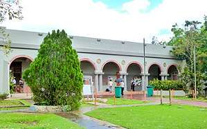
Like all municipalities of Puerto Rico, Villalba is subdivided into barrios. The municipal buildings, central square and large Catholic church are located in a barrio referred to as "el pueblo".[9][10][11][12]
Sectors
Barrios (which are like minor civil divisions)[13] in turn are further subdivided into smaller local populated place areas/units called sectores (sectors in English). The types of sectores may vary, from normally sector to urbanización to reparto to barriada to residencial, among others.[14][15][16]
Special Communities
Of the 742 places on the list of Comunidades Especiales de Puerto Rico, the following barrios, communities, sectors, or neighborhoods the following were in Villalba: Chino neighborhood, Cooperativa neighborhood, Hato Puerco Arriba, Apeaderos, Sector Cubones in Caonillas Arriba, Palmarejo in Villalba Arriba, Céspedes in Pino, Cerro Gordo and Sector El Semil in Villalba Arriba.[17][18]
Energy consortium
An Energy Consortium was signed in late February, 2019 by Villalba, Orocovis, Morovis, Ciales and Barranquitas municipalities. The consortium is the first of its kind for the island. It is intended to have municipalities work together to safeguard and create resilient, and efficient energy networks, with backups for their communities.[19]
Demographics
| Historical population | |||
|---|---|---|---|
| Census | Pop. | %± | |
| 1920 | 13,040 | — | |
| 1930 | 11,847 | −9.1% | |
| 1940 | 12,871 | 8.6% | |
| 1950 | 14,972 | 16.3% | |
| 1960 | 16,239 | 8.5% | |
| 1970 | 18,733 | 15.4% | |
| 1980 | 20,734 | 10.7% | |
| 1990 | 23,559 | 13.6% | |
| 2000 | 27,913 | 18.5% | |
| 2010 | 26,073 | −6.6% | |
| U.S. Decennial Census[20] 1920-1930[21] 1930-1950[22] 1960-2000[23] 2010[11] | |||
Tourism
Landmarks and places of interest
- Guayabal Lake
- La Corona Hill
- Toa Vaca Lake
- Toro Negro Forest Reserve
- Biblioteca Pública
- Centro de Bellas Artes Adrian Rosado
- Iglesia Católica Nuestra Señora del Carmen
Economy
Agriculture
- Coffee, Green Pigeon Peas.
Industry
- Manufacturing of aluminum packaging and electrical and electronic machinery, nutritional products, medical devices, and others.
Culture
Festivals and events
- Matron Celebrations - July
- Puerto Rico Marathon - July
- Areyto Festival - November
- Carlos Báez Marathon - December
- Festival del ñame y carne frita- November
- Celebración del centenario- Abril 2017
Government
All municipalities in Puerto Rico are administered by a mayor, elected every four years. Waldemar Rivera Torres (of the Popular Democratic Party) served as mayor since 2005 to 2012. The current mayor is Javier (Javi) Hernández who was elected in 2013.[24]
The city belongs to the Puerto Rico Senatorial district VI, which is represented by two Senators. In 2012, Miguel Pereira Castillo and Angel M. Rodríguez were elected as District Senators.[25]
Transportation
There are 23 bridges in Villalba.[26]
Symbols
Flag
Four horizontal, unequal stripes in width, that from top to bottom have the following order: green, white, green and yellow. In the immediate side to the flagstaff, in the superior stripe, appears, in white color, the star of the shield.
Education
- Villalba School District (Puerto Rico Department of Education)
- Puerto Rico Criminal Justice College- Villalba Campus (Puerto Rico Police Academy)
See also
- List of Puerto Ricans
- History of Puerto Rico
- Did you know-Puerto Rico?
References
- "Preliminary Locations of Landslide Impacts from Hurricane Maria, Puerto Rico". USGS Landslide Hazards Program. USGS. Archived from the original on 2019-03-03. Retrieved 2019-03-03.
- "Preliminary Locations of Landslide Impacts from Hurricane Maria, Puerto Rico" (PDF). USGS Landslide Hazards Program. USGS. Archived (PDF) from the original on 2019-03-03. Retrieved 2019-03-03.
- Mazzei, Patricia (7 April 2019). "Hunger and an 'Abandoned' Hospital: Puerto Rico Waits as Washington Bickers". Archived from the original on 25 July 2019. Retrieved 31 May 2019 – via NYTimes.com.
- "De La Catastrofe a La Esperanza" (in Spanish) – via www.facebook.com.
- McDonald, Terrence (11 August 2018). "Puerto Rico mayor visits Hoboken to discuss disaster recovery". nj.com. Archived from the original on 31 May 2019. Retrieved 31 May 2019.
- "Hoboken Mayor Returns From Puerto Rico Exchange Trip". NPR.org. Archived from the original on 2019-05-31. Retrieved 2019-05-31.
- Budds, Diana (20 September 2018). "How architects and designers are rebuilding Puerto Rico one year later". Curbed. Archived from the original on 31 May 2019. Retrieved 31 May 2019.
- "Villalba Municipality". enciclopediapr.org. Fundación Puertorriqueña de las Humanidades (FPH). Archived from the original on 2019-11-06. Retrieved 2019-03-20.
- Picó, Rafael; Buitrago de Santiago, Zayda; Berrios, Hector H. Nueva geografía de Puerto Rico: física, económica, y social, por Rafael Picó. Con la colaboración de Zayda Buitrago de Santiago y Héctor H. Berrios. San Juan Editorial Universitaria, Universidad de Puerto Rico,1969. Archived from the original on 2018-12-26. Retrieved 2019-01-01.
- Gwillim Law (20 May 2015). Administrative Subdivisions of Countries: A Comprehensive World Reference, 1900 through 1998. McFarland. p. 300. ISBN 978-1-4766-0447-3. Retrieved 25 December 2018.
- Puerto Rico:2010:population and housing unit counts.pdf (PDF). U.S. Dept. of Commerce Economics and Statistics Administration U.S. Census Bureau. 2010. Archived (PDF) from the original on 2017-02-20. Retrieved 2018-12-26.
- "Map of Villalba at the Wayback Machine" (PDF). Archived from the original (PDF) on 2018-03-24. Retrieved 2018-12-29.
- "US Census Barrio-Pueblo definition". factfinder.com. US Census. Archived from the original on 13 May 2017. Retrieved 5 January 2019.
- "Agencia: Oficina del Coordinador General para el Financiamiento Socioeconómico y la Autogestión (Proposed 2016 Budget)". Puerto Rico Budgets (in Spanish). Retrieved 28 June 2019.
- Rivera Quintero, Marcia (2014), El vuelo de la esperanza: Proyecto de las Comunidades Especiales Puerto Rico, 1997-2004 (first ed.), San Juan, Puerto Rico Fundación Sila M. Calderón, ISBN 978-0-9820806-1-0
- "Leyes del 2001". Lex Juris Puerto Rico (in Spanish). Retrieved 24 June 2020.
- Rivera Quintero, Marcia (2014), El vuelo de la esperanza:Proyecto de las Comunidades Especiales Puerto Rico, 1997-2004 (First ed.), San Juan, Puerto Rico Fundación Sila M. Calderón, p. 273, ISBN 978-0-9820806-1-0
- "Comunidades Especiales de Puerto Rico" (in Spanish). 8 August 2011. Archived from the original on 24 June 2019. Retrieved 24 June 2019.
- Vazquez, Priscilla. "Asociación de Industriales de Puerto Rico". Industriales Puerto Rico. Archived from the original on 2019-03-12. Retrieved 2019-03-16.
- "U.S. Decennial Census". United States Census Bureau. Archived from the original on February 13, 2020. Retrieved September 21, 2017.
- "Table 3-Population of Municipalities: 1930 1920 and 1910" (PDF). United States Census Bureau. Archived (PDF) from the original on August 17, 2017. Retrieved September 21, 2017.
- "Table 4-Area and Population of Municipalities Urban and Rural: 1930 to 1950" (PDF). United States Census Bureau. Archived (PDF) from the original on August 30, 2015. Retrieved September 21, 2014.
- "Table 2 Population and Housing Units: 1960 to 2000" (PDF). United States Census Bureau. Archived (PDF) from the original on July 24, 2017. Retrieved September 21, 2017.
- T, Terrence (11 August 2018). "Puerto Rico mayor visits Hoboken to discuss disaster recovery". nj.com. Archived from the original on 31 May 2019. Retrieved 31 May 2019.
- Elecciones Generales 2012: Escrutinio General Archived December 3, 2012, at the Wayback Machine on CEEPUR
- "Villalba Bridges". National Bridge Inventory Data. US Dept. of Transportation. Archived from the original on 20 February 2019. Retrieved 19 February 2019.