Grandview Township, Washington County, Ohio
| Grandview Township, Washington County, Ohio | |
|---|---|
| Township | |
 Wiley Road near Glass | |
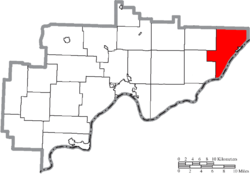 Location of Grandview Township in Washington County | |
| Coordinates: 39°31′9″N 81°6′4″W / 39.51917°N 81.10111°WCoordinates: 39°31′9″N 81°6′4″W / 39.51917°N 81.10111°W | |
| Country | United States |
| State | Ohio |
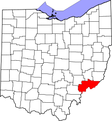
| County | Washington |
| Area | |
| • Total | 35.4 sq mi (91.8 km2) |
| • Land | 35.2 sq mi (91.1 km2) |
| • Water | 0.3 sq mi (0.7 km2) |
| Elevation[1] | 919 ft (280 m) |
| Population (2000) | |
| • Total | 1,834 |
| • Density | 52.1/sq mi (20.1/km2) |
| Time zone | UTC-5 (Eastern (EST)) |
| • Summer (DST) | UTC-4 (EDT) |
| FIPS code | 39-31276[2] |
| GNIS feature ID | 1087133[1] |
Grandview Township is one of the twenty-two townships of Washington County, Ohio, United States. The 2000 census found 1,834 people in the township, 877 of whom lived in the unincorporated portions of the township.[3]
Geography
Located in the eastern corner of the county along the Ohio River, it borders the following townships:
- Benton Township, Monroe County - north
- Jackson Township, Monroe County - northeast
- Independence Township - southwest
- Ludlow Township - west
- Washington Township, Monroe County - northwest corner
West Virginia lies across the Ohio River to the southeast: Pleasants County in the far south, and Tyler County otherwise.
The village of Matamoras is located in the eastern part of the township along the Ohio River.
Name and history
It is the only Grandview Township statewide.[4]
Government
The township is governed by a three-member board of trustees, who are elected in November of odd-numbered years to a four-year term beginning on the following January 1. Two are elected in the year after the presidential election and one is elected in the year before it. There is also an elected township fiscal officer,[5] who serves a four-year term beginning on April 1 of the year after the election, which is held in November of the year before the presidential election. Vacancies in the fiscal officership or on the board of trustees are filled by the remaining trustees.
References
- 1 2 "US Board on Geographic Names". United States Geological Survey. 2007-10-25. Retrieved 2008-01-31.
- ↑ "American FactFinder". United States Census Bureau. Archived from the original on 2013-09-11. Retrieved 2008-01-31.
- ↑ Washington County, Ohio — Population by Places Estimates Ohio State University, 2007. Accessed 15 May 2007.
- ↑ "Detailed map of Ohio" (PDF). United States Census Bureau. 2000. Retrieved 2007-02-16.
- ↑ §503.24, §505.01, and §507.01 of the Ohio Revised Code. Accessed 4/30/2009.